
Most of us will never climb Everest, but the mountain still looms large in our minds every spring when hundreds of hearty souls travel there for adventure. Everest sits on the border between Nepal and China, and the most popular route to the top has long been via Nepal, on the mountain's south side. Here's��an overview of what that journey entails.
Much of this text originally appeared in What You Missed: Everest, a limited newsletter series published in 2018. We'll be publishing What You Missed: Everest in 2019 as well: subscribe to this��email list��to receive the special Everest edition every Saturday during the climbing season, starting March 30. While climbers are��resting and getting their bodies used to the altitude at various camps on the mountain, we'll be sending you��updates on various expeditions, alongside��historical context from ���ϳԹ���'s vast Everest story archive.
Getting to Base Camp Is Its Own ���ϳԹ���
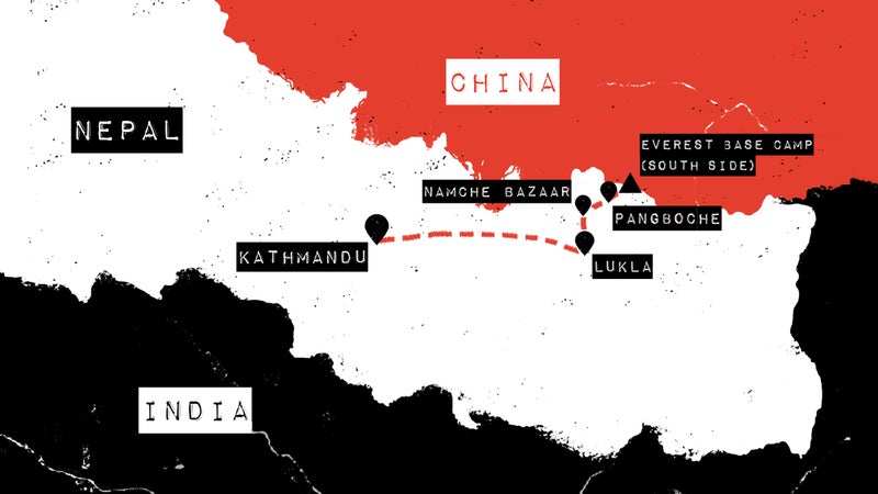
If you’re climbing Everest from the south side, as the majority do, you’ll likely start in Nepal’s capital city of Kathmandu before making a seven-to-ten day trek to Base Camp.
Trekking through Nepal’s Khumbu Valley is incredible—and for some, it’s a once-in-a-lifetime journey all by itself. (We named the Everest Base Camp trek one of the top 25 hikes in the world this year.)
The trail to Everest starts in the village of Lukla, at 9,334 feet. Most folks take a short airplane flight or 45-minute helicopter ride to Lukla from Kathmandu. And, uh, you may have heard that flying into Lukla’s Tenzing-Hillary Airport requires landing on the . Here’s , by 12-time Everest climber Kenton Cool.
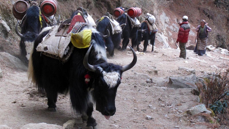
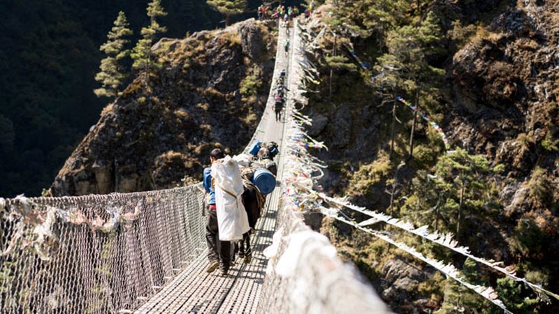
Trekkers who find their nerves rattled after getting off the plane can walk a few feet from the runway to the German Bakery Café, for a sweet treat and a caffeine hit. You might rest for a day in Lukla to get used to the altitude before continuing on your trek, which will be hot, dusty, and filled with yaks and swaying suspension bridges.
You’ll likely spend a night or two in the village of , at an altitude of 11,500 feet, with downtime at��coffeehouses that serve very good lattés alongside incredible views. is a popular place to stay in Namche, with guest rooms named after famous mountaineers, and is your destination for Guinness, free movie screenings, and foosball.
At 13,000 feet, you might stop in Pangboche, where Lama Geshe (who died in February 2018) used to bless Everest climbers every spring.
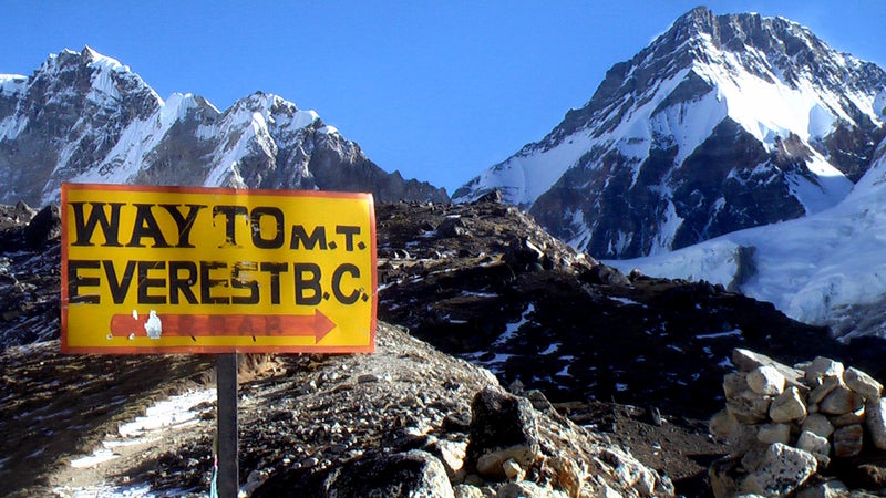
A few days later, you’ll stumble in to Base Camp at 17,500 feet. Hopefully you’ve acclimatized properly and aren’t suffering from altitude sickness.
Life at Everest Base Camp
Pretty much everything you need to know about Everest Base Camp in Nepal was written down by ���ϳԹ��� contributing editor Kevin Fedarko in 2007:
You know you've arrived when the trail slams up against a soaring atrium of ice-enameled rock that serves as a kind of Maginot Line separating the Indian subcontinent from the Tibetan Plateau. From this spot, you can see the tops of five world-class leviathans: Khumbutse, Nuptse, Lhotse, Pumori, and Lingtren. Everest is here, too, but its summit is invisible, tucked behind the mountain's West Ridge. After a moment, your gaze peels away from the imperial-looking ridgelines and the cobalt-colored sky and tumbles down the mountain to the disheveled surface of the Khumbu Glacier, where roughly 11 bajillion tons of rubble are convulsing beneath your feet, emitting a grunting chorus of odd pops, ominous hisses, and digestive gurgles.
It's a weirdly unstable platform. Every couple of hours a new fissure winks open or another humpbacked stone slides into a pool of meltwater with a blooping splash, like a walrus returning to the sea. And thanks to all that restless heaving, it's the last place you'd expect to find, say, a small city. Yet as McBride and I could see, somebody had obviously decided it was the perfect spot to stage an entire Renaissance Faire.
Prayer flags streamed in all directions, snapping crisply in the hypoxic breeze at 17,600 feet. Beneath those flags sprawled an alpine metropolis of more than a thousand people crammed into some 250 tents that had been stocked with 3,000 yakloads of gear, food, and medical equipment (and which required a resupply of 200 additional yakloads every two weeks). The 27 expeditions spread along this half-mile strip had turned the place into a cross between a Central Asian bazaar and a pre-Christmas PlayStation sale at Wal-Mart. While cooks bartered everything from flashlight batteries to maple syrup, porters clad in shower sandals staggered beneath gargantuan loads of climbing rope, whiskey, and aluminum ladders. Crampon-clinking Sherpas mingled with windburned climbers, shuffling trains of exhausted yaks, officious-looking liaison officers from the Nepal Ministry of Tourism, and nappy-coated pack ponies whose saddle bells jingled merrily in the frost-chilled air.
That’s EBC in a nutshell. A decade later, not much has changed—other than, perhaps, more reliable WiFi. Read the rest of Fedarko’s dispatch for the full scoop on why this place qualifies as the world’s most exclusive party town. Also check out “Base Camp Confidential,” by Brad Wetzler.
Speaking of parties, no one was surprised when DJ Paul Oakenfold traveled to Base Camp to play a set in 2013:
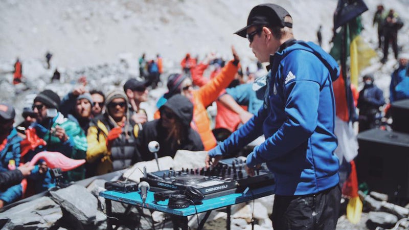
Jen Murphy reported for ���ϳԹ���: “The audience of about 100 puffy coat-wearing Sherpa, guides, and climbers danced along to his trance-like beats, waving selfie-sticks in the air. A bottle of whiskey made its way around the crowd and one reveler even used their hiking boot to chug a beer.”
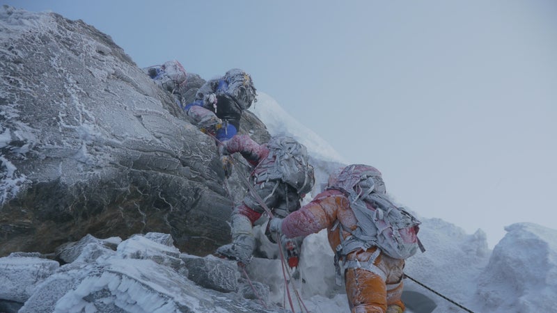
Your First Obstacle—the Khumbu Icefall
. . . “.” These are the words people use to describe the Khumbu Icefall, for climbers ascending the south side of Everest.
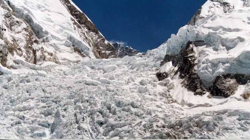
Each spring, a team of eight to ten Nepali climbers known as ��go into the Icefall first and decide what route everyone’s going to follow through it. They string up ropes and secure aluminum ladders that make it possible for hundreds of other people to get from Base Camp to Camp I on Everest in the following weeks.
As a client on a guided Everest expedition, you might take your first steps through the Icefall on a sunny afternoon, when the only goal is to practice crossing the ladders installed across the terrain’s chaotic jumble of ice blocks, towers, and crevasses. You’ll hear the Khumbu Glacier creak and you’ll feel it heave, because it’s moving all around you. The Icefall itself migrates downhill from Camp I (19,900 feet) to Base Camp (17,600) at a rate of a few feet per day.
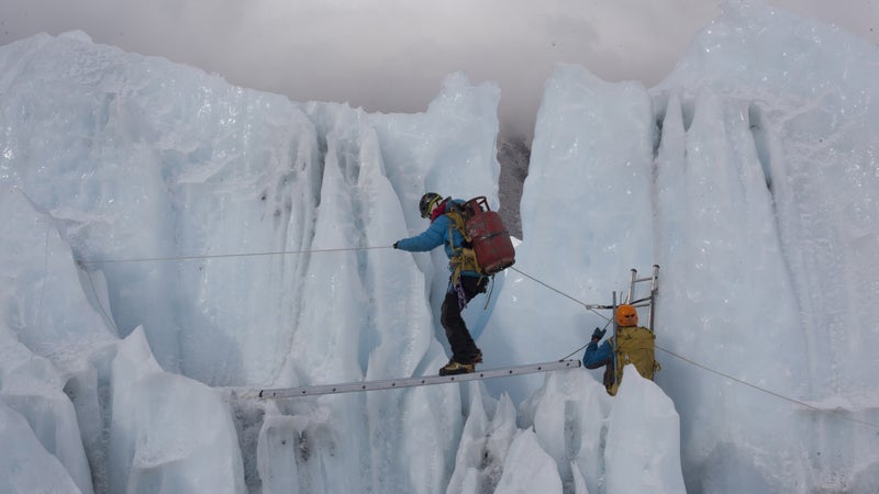
The next time you cross those ladders, it might be dark—you’ll have gotten up before dawn because you’re headed all the way up to Camp II, and at each ladder, you’ll have to wait for a dozen other climbers lined up ahead of you. You’ll be grateful that, with only the light of your headlamp, you can’t see every crevasse in all its terrifying depth. You might traverse the Icefall a total of four or six times, making acclimatization rounds up and down the mountain before your summit attempt. The Sherpas employed by your guiding company will make .
The Khumbu Icefall is where 16 Sherpas were killed by “an ice chunk the size of a ten-story apartment building” in April 2014. , ���ϳԹ��� editor-at-large Grayson Schaffer noted that at least 100 Sherpas were in the Icefall at the time. It underscored not only the danger of the Icefall but also —between the risks that Sherpas are subjected to and the ones that apply to everyone else.
Still, as multiple sources told Schaffer, every individual who sets foot in the Khumbu Icefall is “taking a gamble.”
The Western Cwm
After climbing through the Khumbu Icefall, you’ll be in or on what’s known as the Western Cwm of Everest. It was named by George Mallory in 1921. “Cwm”��is the Welsh word for “valley.”
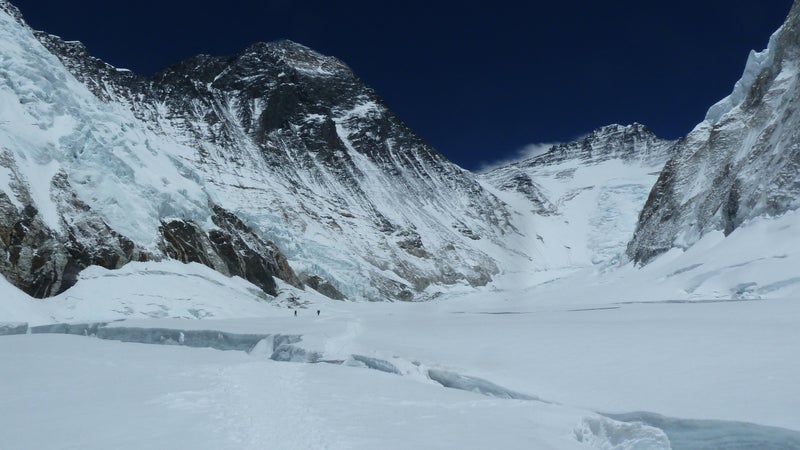
By the way, “cwm” rhymes with “doom,” but this section of the mountain isn’t terribly scary—unless you . The relatively flat, 2.5-mile long valley is flanked on three sides by the slopes of mounts Everest, Lhotse, and Nuptse; the sun reflects off those flanks and bakes the Western Cwm to the point where climbers often feel the need to strip down to t-shirts during the day.
“You literally pray for a puff of wind or a cloud to cover the sun so you can keep moving up to Advance Base Camp,” climber .
You’ll rest at Camp I at the beginning of the Western Cwm, at an elevation of about 19,500 feet, near the top of the Khumbu Icefall. Then you’ll cross the Cwm to get to Camp II, also known as Advanced Base Camp, at about 21,000 feet.
The Lhotse Face
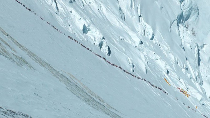
The route from Camp II to Camp III on Everest, if you’re taking the popular , entails climbing up the side of Lhotse—the world’s fourth-highest mountain. The “Lhotse face,” as it’s called, is extremely icy and ranges from 45 to 55 degrees in slope. That’s steep, and you’ll be clipped in to a rope while methodically kicking your crampons into the ice for three to six hours. Expect traffic. This is the section where German mountaineer Ralf Dujmovits snapped of what looked like a conga line of climbers in 2012.
As climber Mark Pfetzer wrote in his 1998 memoir : “When you meet someone coming down or are passing someone going up, there’s a little dance you have to do. You unclip from the rope, dangerous at that steep an angle, grab hold of the other guy’s clothes, edge around him as he hangs onto the rope with both hands, then clip on again. Do this dance four or five times as I do, and you can’t help but think it’s a traffic jam at 24,000 feet.”
Every team picks its own space for what it calls “Camp III,” between 23,000 and 25,000 feet, since flat camping space is limited at this point on the mountain.
The South Col
Progressing from Camp III up to the South Col on Everest entails more steep, icy climbing on the face of Lhotse before reaching a section of limestone rock known as the Yellow Band. Then you’ve got to cross a rocky outcropping called the Geneva Spur, at about 24,000 feet.
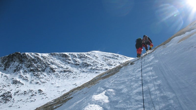
Here’s how Leif Whittaker, who climbed Mount Everest in 2012 (and is the son of Jim Whittaker, to climb Everest), described this section in his memoir My Old Man and the Mountain.
The rock of the Geneva Spur forms interlocking sheets, some as thin as cardboard and others as thick as the spine of a dictionary. The entire Spur looks like a sculpture of a library tilted on its side, books falling out of the shelves here and there. We crest the Spur and the wind immediately picks up. Lhotse’s no longer protecting us. The South Col, a saddle in the ridgeline that connects Mount Everest to Lhotse, is directly ahead. A layer of stale, wrinkled ice covers the saddle like old skin hanging loosely from a bony spine. Dozens of bright tents cling to the ice, their walls flapping and their poles flexing beneath gusts. My watch says 26,013. Welcome to the death zone.
The term death zone originated from Swiss doctor Edouard Wyss-Dunant, in the 1953 edition of , a research journal that he contributed to after his own failed attempt to climb Everest in 1952. Wyss-Dunant’s original phrase was reportedly “la zone fatale,” but here are his words as published in the English publication of The Mountain World.
I have spoken of “the lethal zone”: it is fitting to give some explanation of this term. Survival is the only term suitable for describing the behavior of a man in that mortal zone which begins at about 25,500 feet. Life there is impossible and it requires the whole of a man’s will to maintain himself there for a few days. Life hangs by a thread, to such a point that the organism, exhausted by the ascent, can pass in a few hours from a somnolent state to a white death.
in mountaineering vocabulary ever since. The concentration of oxygen in the air in the death zone is around 30 percent of what’s available at sea level.
Climbing Everest in 2019, you’ll be wearing a full-body down suit and also likely using supplemental oxygen at this point. The South Col is where you’ll establish Camp IV, the last place you’ll sleep—hooked up to an oxygen machine, with hurricane-force winds battering your tent—before trudging up to Everest’s summit.
To the Summit
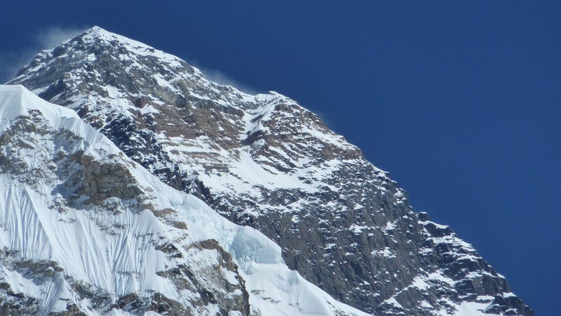
Summit day starts dark and early at Camp IV, around 26,000 feet on the South Col, where you’ll crawl out of your tent around midnight and set out for a long, slow walk.
After a few hours ascending a steep slab known as the Triangular Face, or Everest’s South Face, clipped to ropes and stepping over a mix of rock, ice, and snow, you’ll come to an outcropping known as the balcony—a popular spot to stop and replace oxygen bottles if needed, and try to take in some food and water.
Your next big pause is at the South Summit, an icy dome about 400 feet from the true summit. Then it’s on to the southeast ridge—also known as the knife edge, or the Cornice Traverse—a section where you can see straight down 8,000 feet to the west and 10,000 feet to the east.
What comes next is the —although this iconic feature is now just a shell of its former self, having crumbled in 2015. Long one of the most foreboding obstacles on the mountain, this used to be a near-vertical outcropping comprising four large boulders and several smaller rocks stacked on top of each other.
As several climbers , the main boulder—the largest and highest rock in the feature—is now gone, likely shaken loose during the massive Nepal earthquake of 2015.
Still, this section requires climbers to summon all their strength and nerve, pulling themselves awkwardly up a fixed rope. It’s probably been 10 or 12 hours since you left your tent at Camp IV. Every breath and every muscle movement is tough. Once you’ve gotten over the Step, give yourself a pat on the back and then keep trudging forward. The summit is in sight now, and adrenaline helps you walk the final 200 feet up the moderate slope.
And then you’re on top of the world. You should be able to look down on the tops of other great Himalayan peaks—Lhotse, Nuptse, Makalu, Cho Oyu, Ama Dablam, and more.
Your Way Home
After reaching the top of Everest, you’ll beat a hasty retreat down the mountain back to Base Camp, where you won’t stay long. Expedition staff will break down and pack up your team’s Base Camp site while you hightail it to Kathmandu.
Back in Nepal’s capital, celebrate your achievement with a free dinner at —where the likes of Edmund Hillary and Reinhold Messner have all dined and left their signatures on cardboard cutouts of Yeti footprints posted on the wall. The restaurant is named after the fictional highest mountain in the world, with an elevation of 40,000 and 1/2 feet, from the now-classic mountaineering story .
If you’re lucky, you’ll spend a night or two at the historic —another establishment that’s for decades.