


����…��dz�’r�� planning a ski trip over the holidays. You’re probably curious about the snow outlook. Well, the good news is that after a parched summer and fall throughout much of the West, El Niño has brought fresh powder to a number of ski areas in the Rocky Mountains—and forecasts predict the precip will keep coming.
An El Niño occurs when sea surface temperatures in the eastern Pacific Ocean near the equator are warmer than normal for several consecutive months. (A La Niña is the opposite of an El Niño, occurring when these��waters are cooler than normal for the same period of time. The standard temperature anomaly used to define an El Niño or La Niña is half a degree Celsius above or below normal, respectively.)
Over time, we’ve come to recognize these oceanic temperature anomalies as an important influence on global weather patterns; it’s hard to talk about a hurricane season or the potential for a snowy winter without discussing temperatures in the Pacific Ocean.
The latest report, issued��December 13, from NOAA’s Climate Prediction Center showed of an El Niño forming in the Pacific this winter. Sea surface temperatures in the all-important eastern equator region of the Pacific have been above normal since July and the water has steadily gotten even warmer this fall. We could soon be in a full-fledged El Niño if these trends continue.
El Niño and La Niña can have a significant effect on weather patterns in certain parts of the world. These two phenomena are pretty cool examples of teleconnections—how different parts of the atmosphere can influence one another even if they’re separated by thousands of miles. It doesn’t seem like water temperatures fluctuating a degree or so either way could have that much of an effect on weather patterns. But just like we’re seeing with climate change, it doesn’t take much of a temperature difference over a long period of time to disrupt the atmosphere’s delicate balance.
It helps to understand how the jet stream forms in order to understand how El Niño affects winter��in the U.S. The jet stream is a fast-flowing stream of air in the upper atmosphere that typically meanders around the cruising altitude of most��aircraft. Almost all of our exciting weather in this country is caused by the orientation and speed of the winds in the jet stream—these dips and streaks in the upper-levels lead to rising and sinking air near the surface, which can create everything from intense storms to clear blue skies. ��
The atmosphere is fluid, always churning and bubbling. Some of these disturbances are as small as a neighborhood—rising air forms a puffy cloud over your house—and some can turn into enormous storm systems that sprawl across the continent. We also have extremely large air circulations throughout the atmosphere known as “cells.” The cells are roughly oriented north-south and each take up about 30 degrees of latitude. In the northern hemisphere, the jet stream forms from the sinking air in these cells around 30°N and 60°N. The southern one is known as the subtropical jet stream, while the northern one��is the polar jet stream.
Most of our weather systems in the U.S. are caused by the polar jet stream, or the one that lingers around southern Canada, occasionally dipping south of the border to create storms that sweep across the country.��But El Niño can disrupt that. The warmer-than-normal sea surface temperatures over the��Pacific add extra heat to the atmosphere, helping to bend and twist that subtropical��jet stream to cause unusually active winter weather across parts of the country.
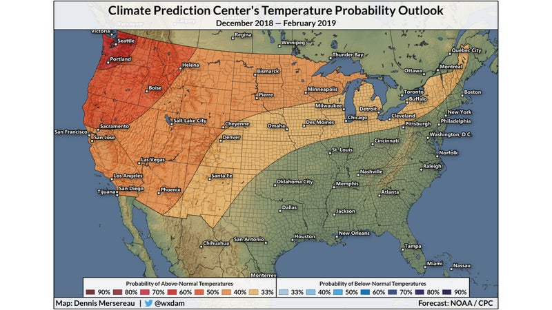
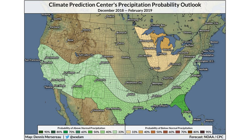
The from the Climate Prediction Center line up pretty well with the graphics you’d see in the El Niño chapter of a meteorology textbook. The agency expects warmer-than-normal temperatures to persist across the West, as well as the classic uptick in precipitation across the southern half of the country.��
Forecasters expect a weak El Niño if current trends hold up throughout the rest of the winter. A stronger El Niño has a better chance of affecting weather conditions in the U.S., but even a weak one��can still lead to stormy, wet conditions.��So what does that mean for your ski trip?��When it comes to snow out West, El Niño really only tends to help if you’re in southern California, the desert Southwest, or the southern Rockies; expect those places to get near- or above-average snowfalls. El Niño patterns typically leave the Pacific Northwest and northern Rockies warmer- and drier-than-normal—not completely without snow,��but less than they’d expect during a normal year.
Whatever happens this winter won’t solely be the result of El Niño, but the weather pattern��could certainly leave its mark on a number of states in the coming months. Areas in the Northwest won’t go completely snowless this year, while��many areas in the south��probably won’t have more snow than they’ll know what to do with. Seasonal snowfall totals depend on lots of factors. Think of El Niño��as��an added bonus.
In short: Go��book a trip to the Rockies, then cross your fingers.����