

Earlier this month, Colorado’s Wolf Creek, with a reported 22-inch base, became the first U.S. ski area to open this winter. When can we expect real snow accumulation in other parts of the country?
First, you should know that meteorologists are particular about how they measure snow. For the snow to be considered “measurable,” you need at least 0.1 inch of accumulation. That tiny threshold is what most of us would call a dusting. A “trace” of snow means the flakes melted as soon as they hit the ground; it’s not measurable.
Sleet is measured and reported as if it were snow. Sleet, or ice pellets, forms when a snowflake falls through a shallow layer of warm air above the surface and refreezes before it reaches the ground. Sleet accumulates like snow, and even though it’s icier and more dangerous than a fluffy pile of powder, it’s counted as such in the record books.
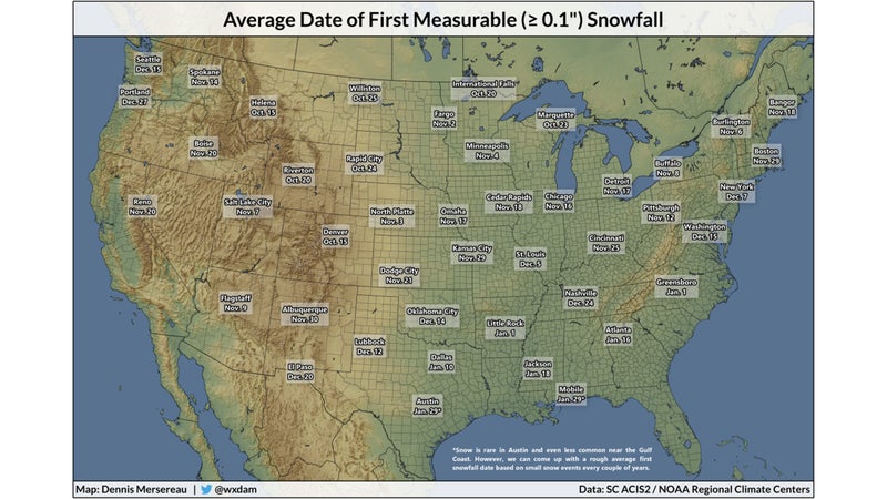
The above map shows the average first date of measurable snowfall around the United States. (Some cities have multiple weather stations, so I used the one that has the longest reporting record, most of which go back at least 70 years. I used National Airport for the average first measurable snowfall date in Washington, D.C.; Central Park for New York City; and O’Hare Airport for Chicago.)
Some cities reliably record snow every year on those dates, while others go many years without seeing so much as a single flake. Snow is (shockingly!) rare in places like Austin, Texas, and Mobile, Alabama, but they see small winter storms every couple years, and it’s possible to estimate an average first snowfall date from those events.
The pattern of first measurable snows across the country are fairly predictable. It starts snowing before Halloween near the Rocky Mountains, while it typically doesn’t start snowing in the South until after January 1—if at all. Higher elevations can start seeing feet of snow as early as the beginning of October, with measurable snows reaching population centers like Helena, Montana, and Denver, Colorado, by the middle of the month. Canada begins exporting cold air in earnest by the end of October, increasing the chances for snow across much of the northern Plains and Upper Midwest.
Lake-effect snow is the big story once November rolls around. Lake-effect snow is caused by convection, the same process that creates thunderstorms. Warm air immediately above the relatively warm waters of the Great Lakes can quickly rise through bitterly cold air in the atmosphere above. The resulting bands of snow can dump many feet of snow in one day, sometimes in narrow swaths just a few miles wide. Buffalo, New York, sees several major lake-effect snow events every year. One of the city’s suburbs saw back in November 2014, while communities a few miles up the road saw barely enough to shovel away.
By the end of November, a large portion of the United States has reached the date it typically sees its first measurable snowfall. The Northeast and Mid-Atlantic typically see their first by the beginning of December, as clippers become commonplace. (A clipper is a small, fast-moving weather system that comes from the northwest and can drop a quick coating of snow before the skies clear out.)
We usually start seeing significant winter storms by the middle of December. Powerful low-pressure systems moving across the central United States can cause paralyzing blizzards on the Plains. Strong storms that develop near the East Coast, known as nor’easters, are the source of most major snowstorms in the eastern states. In addition to possibly dropping feet of snow on major cities from North Carolina to Maine, nor’easters can produce winds as intense as a hurricane, and the strongest ones can even develop a hurricane-like eye. These powerful storms are usually responsible for accumulating snows in the southern United States, where cities like Greensboro, North Carolina, and Atlanta, Georgia, typically don’t see their first coatings until after the new year. It’s tougher for snow to fall as you get closer to the Gulf Coast, but every once and a while all the ingredients can come together to allow a winter storm to reach the beaches of the Gulf.
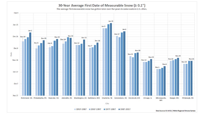
The average date a city sees its first measurable snow is just that—an average. Averages change with time and can vary depending on the period of data in question. For this post, I used a station’s entire period of record, which stretches more than 100 years in New York’s Central Park and just 59 years at Chicago’s O’Hare Airport. If you change those periods to just 30 years, which is the standard period of time to figure, some interesting trends emerge.
The average first date of measurable snow is gradually getting later in the year in some eastern U.S. cities. Philadelphia, for instance, has seen its first snow slip by two weeks over the past 60 years. The average first snowfall date in Philly was December 6 for the period between 1957 and 1987, but the date gradually moved back to December 20 by the 30-year period between 1987 and 2017.
Some of these changes are attributable to long-term weather patterns, but climate change could also play a role. Climate data shows that many cities (including Philadelphia) have seen their first freeze and their last freeze earlier in the spring. The during winter in North America has also been on the decline since the 1970s. This trend of later first snowfall events in the eastern United States could be a part of this overall warming trend.
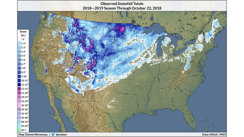
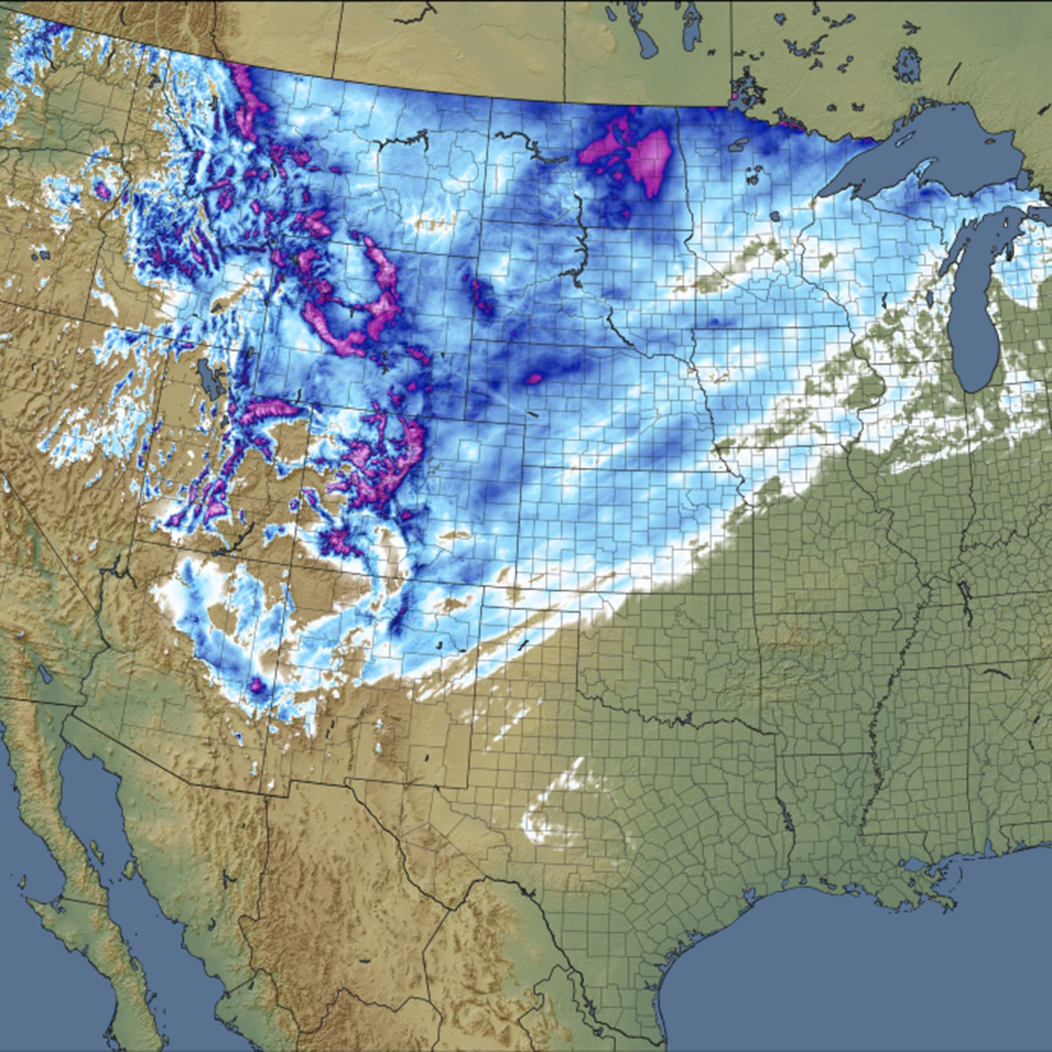
Despite this year’s unusually warm fall for a large part of the United States, much of the central part of the country saw its first measurable snow a lot earlier than usual. Measurable snow fell as far south as Texas this year as a result of a robust storm that coincided with a burst of cold air flowing south from Canada. Seasonal snowfall maps will start filling in as we head into November and cold air rules the day.