[MUSIC PLAYING] SPEAKER 1: I brought you guys a ruler.
SPEAKER 2: [INAUDIBLE] Sierra. Our storm system--
[RADIO TUNING OUT]
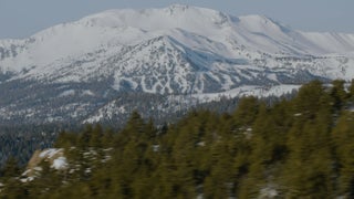
SPEAKER 3: Good morning, skiers and snowboarders. This is Lauren with your Mammoth Mountain snow report. It's been a wild four days at Mammoth, and this megastorm has officially cleared, leaving us with a total of 89 to 132 inches this Saturday. We're looking at clear skies, cool temperatures, and mild winds today, making for an incredible powder day.
[MUSIC PLAYING]
HOWARD SHECKTER: Let's just talk about the winds blowing up over a mountain. Remember, we started with a full boat of moisture. Those winds are running perpendicular to the mountain. And because of the mountain, the air is forced to rise, just like a sponge. You're just wringing that sponge out all the way to the top. And then when the air comes down on the east side, you're letting go of the sponge.
By the time you get to Highway 395 and east, they're going to get a fraction to what Mammoth Mountain will get. And because Mammoth Mountain sits at a low spot in the Sierra, they're always going to get their lion's share. And even though the storm may be stronger to the north, Mammoth Mountain could get equal amounts to areas to the north. I mean, Dave really picked the right mountain to put a ski area on. I mean, couldn't have done a better job.
[MUSIC PLAYING]
If it's strong enough, there are certain signals in certain areas that provide what we call teleconnections to West Coast weather. And they're not 100%. What I did this particular winter and going out three weeks ahead of time and calling for a major storm was I knew the speed of the MJO. And it was forecasted to go into a certain region. And because of the time of year and the way the pattern was set up, it looked like we were going to get walloped for about 10 days.
[MUSIC PLAYING]
Some of the things I'll look at is the precipitable water channels. That's where you'll find the atmospheric rivers. If you're looking at amounts of 2, 3 inches in a storm within a 24-hour period, you're looking at most likely a storm that's got an atmospheric river connected to it, especially on the east side.
There's the atmospheric rivers that develop and ride the ridge line into California that don't have any cold air with them. And those are horrible because they're just rain, and they can rain up to 12,000 feet. It's the ones that become confluent with arctic air are the ones that give us the most snow. And we have a lot of those this winter because we had a perpetual arctic low off the coast of the Pacific Northwest and that low phase with atmospheric rivers all winter, especially in February, because that's where we had a record February. It's when you get those two features together. And they can just dump a lot of snow.
[MUSIC PLAYING]
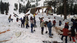
SCOTT QUIRSFELD: If it snows overnight, I'll get up usually around 3:00 AM, look at the site while having a cup of coffee in the morning. And usually up here by about 4:00, look at our weather site again, jump on a snowmobile, go out to the site. And then that's when we do our manual measurements to confirm what's being digitally recorded. The main lodge snow study site is just a little over 9,000 feet. Some of the other sites are on the other side of the mountain so that the patrol that's coming out of Canyon Lodge is able to get an idea of what's fallen at some of our lower elevations and on their side of the hill.
Right now our site has two boards. One is a storm board, and one is a 24-hour board. That's the times that we measure the snow and we'll clear that board. And it's just a piece of plywood with a steel shaft coming out. And they also have a digital sensor that comes over the board and measures the snow.
With the scale, we have just a plastic tube and a scale. We measure the height and weight of the snow. We call it the SWE, the snow water equivalent of that snow that's fallen in a 24-hour period.
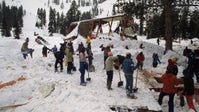
Once we've finished measuring, we'll come back in, and we'll fill out an operation stability analysis. And that just gives us an idea of hazard rating for us on the hill and what we'll be dealing with. So whether it's wind slabs or storm slabs, corners development, things like that, we'll fill out this stability ratings and pass that information along to the crew. The management team comes up with a game plan for how we're going to do our snow safety work. Yeah. And then we go out and do it as quickly and safely as we can.
SPEAKER 4: Poor visibility. Mid-mountain is the same thing, that wind slab and a storm slab. That storm slab will be a high hazard, and the wind slab will be a [INAUDIBLE]. Both are trending up with today's forecast. The winds today should be--
SCOTT QUIRSFELD: It's like an orchestra, hopefully not a circus. And we all try to work together. We communicate with them with our daily objectives. And they communicate with us what their goals are for the day. We try to achieve those. And if not, we try to find some common ground. But it's all about working together as a team, coordinating our work with all the lift operations, lift maintenance, and all the other snow placements, snow cats, all the other departments.
JEFF DOZIER: If you look at a sort of map of the Sierra, Minaret Summit is about the lowest point in the crest of the Sierra in 100 miles in either direction. And so a lot of the storms come right up the San Joaquin. We sit just over the crest from those storms. And so we get a lot of snow here.
The reason the Sierra is so interesting is that about 2/3 of the water that we use for irrigation in the state of California comes out of the snowpack. The way that we allocate water and plan to manage the reservoirs during the spring and the summer depends on having some knowledge of how much water you're going to get. And so in addition to describing the depth of the snow, we characterize it by what we call the snow water equivalent.
The one thing recently that gives us the possibility of measuring snow water equivalent everywhere is the airborne snow observatory. It uses a lidar altimeter. That is, it shines light, a burst of light from the airplane, and you time how long it takes that light to get to the surface and come back. And then that tells you how far below the airplane the surface is. And if you know the elevation of the airplane, then you know the elevation of the surface.
So what they do with the lidar, they measure it during the dry season when there isn't any snow on the ground. And then they fly it throughout the winter. And they measure the elevation with the snow on the ground. And you do the subtraction, and you then know what the depth of the snow is.
We, of course, use the facilities of the mountain at our snow study site. And the mountain actually uses our data when they report the depth. They use their own measurement, the ski patrol measurements down at the bottom. And then they look at our site's data to have an idea of what's going on on mid-mountain.
One of the things I think, not just in snow hydrology, but in hydrology generally, we're perceived to be important to the extent that we're useful. A lot of the research that I do, therefore, is directed toward questions that have societal importance. So basically what we're trying to do is understand the role of the snowpack in the hydrology and the climate of mountainous areas.
[MUSIC PLAYING]
[LAUGHTER]