

One of my favorite brown and rainbow trout spots is a really tough hole. I’ve pulled some big fish from this medium-sized Vermont pond, but it’s pretty hit-or-miss. On hot days, kids regularly swim to the middle and stand waist high. I knew my trout probably weren’t lurking in 2 feet of 80-degree water, so I resorted to a fish finder to help me identify the trout-friendly spots.
To learn more about the pond, we padded it with Garmin’s , one of the most technically advanced fish finders, GPS navigators, and depth sounders in a small, simple package. Where many GPS and sonar units are sized for ocean cabin cruisers, this unit weighs a mere 1.9 pounds and measures around 6 inches square. It’s so easy to install that we temporary mounted it on our kayak.
A discarded wooden bookshelf served perfectly as a way to anchor the echoMap 50s on the kayak (and offer cup holders). We bail mounted the waterproof, color screen to the shelf, and connected it to a 12-volt hobby battery locked down in the kayak’s hatch. We lashed the sonar sensor (the transducer) to a fat wooden dowel at the bottom of the bookshelf underwater using zip ties. Fish finders usually attach the transducer to a transom, hull, or trolling motor, but our setup worked great.
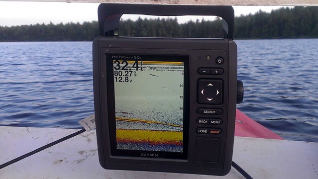
The echoMap 50s delivered stunning, clear images of large fish hanging out near the bottom, fallen trees, rocks, and small baitfish congregating near the surface. It was easy to see what and where everything was. Revelations came when we discovered our pond was really a complex underwater topography of two large trenches 40 feet deep in a horseshoe shape. In some places, the bottom rises precipitously toward the sand bar in the middle, and that’s where large fish (presumably our trout) were usually congregating. We made sure to mark the spots with the Garmin’s waypoint button.
The echoMap 50s has many features beyond the ones we use. There are 17,000 lakes programmed into the unit, some with contours already provided down to 1-foot resolution. And just like with a car’s GPS, the 50s can navigate you to a fishing spot by choosing the best, safest route—even factoring in a lake’s depth on the day you’re using it.
For us, it was all about the simple interface and the way the device showed underwater features with clarity. Baked into the unit are technologies such as AutoGain, which minimizes onscreen clutter, and See-thru, which shows fish beneath obstacles. These helped us understand the shape and fauna of our spot. And the next time we bring a buddy fishing without any electronics on the boat, we’ll appear to have a sixth sense about where all the fish are.
$450 basic unit with U.S. basemap; $500 with transducer; $550 with transducer and U.S. lakes map