
Four months after crashing their flying boat and escaping a deadly rebel assault that left one man dead, millionaire British adventurer Neil McGrigor, 44, and his three-man Ascend the Nile Expedition are getting back on the river in March. McGrigor's team set out from Rashid, Egypt, on September 20 and headed upriver in an attempt to prove their theory that cartographers have misjudged the true source and, thus, length of the 4,160-mile river by about three miles. Employing GPS units and inflatable motorboats—one equipped with an ultralight wing and propeller, to fly over rapids—the team planned to prove it. But on November 8, McGrigor crashed the flying boat 3,300 miles into the trip, near Uganda's Murchison Falls, where government troops have been battling insurgents for 19 years. British guide Steve Willis, who was operating a camp nearby, came to the team's aid. But as they left, Willis's Land Rover was ambushed by a pair of rebels, who killed Willis. A bullet also grazed expedition member Garth MacIntyre's head, and team co-leader Cam McLeay was treated for severe infections after running 21 miles barefoot through the bush for help. Both have vowed to continue with the expedition. Justin Nyberg caught up with McGrigor as the team prepared to get back on the river.
OUTSIDE: What happened when you were attacked?
McGRIGOR: We all fled, but the rebels found me and took me back to the Land Rover to help them loot it. Then one gunman forced me to kneel on the ground. I thought I was going to be shot. To my absolute surprise, they turned and left.
Why go back?
We set out to ascend the whole Nile—from sea to source—measure it, and establish the farthest source. We haven't done that. Why should terrorists or gunmen get in the way? We've got to have some good come of what we've done, if only to remember Steve. Otherwise it's been a failure.
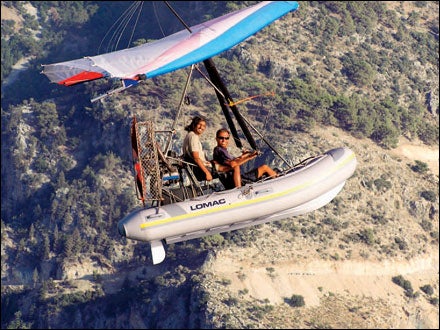
What about the flying boat?
We needed it to lift our equipment over Murchison Falls and more than a dozen rapids. We still have half the rapids to go.
How can the Nile's source still be in question?
In Rwanda, the only proper mapping was done by the Belgians in 1937, but the maps are wrong. Nobody has been to the farthest source of the Nile, and I've determined where it is.
Surely people know about this other source.
People might have pinpointed it, but no one has been to it—or accurately mapped it.
Did you use satellite images?
No, I went out there with a helicopter. We did use Google Earth to help navigate the labyrinth of waterways in Sudan's Sudd marshes, though.
Are you going in armed this time?
We will have suitable protection.