

Backcountry skiers now have another important tool in their safety arsenal: , a new app that launched on Wednesday. Created by , the company that makes the SP2 avalanche probe, the free app crowdsources snow, weather, and avalanche data to create an information center on your phone. There’s also a paid version that helps skiers with route finding.
“We built this app to the highest professional standards, so it’s useful for the snow safety community as well as your average skier who may have taken an Avy 1 course,” says Brint Markle, co-founder and CEO of Avatech.
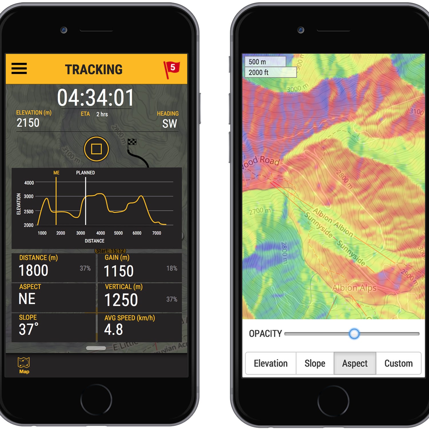
Here’s how it works: On the free version, you launch the app while you’re out skiing. You then make observations about weather and snow (new snowfall, wind direction, basic snowpack information, or even avalanches) and input those observations in specified fields within the app. You can also upload photos and video to provide more detail. All this information is then uploaded into the Avanet database when your cellphone has service. In theory, the database becomes a searchable resource for backcountry travelers using the app.
Down the road, the hope is that when you head out to ski, you’ll not only check your local avalanche forecast but also consult the location-specific data Avanet provides. For example, if you know you’ll be skiing at around 11,000 feet on north-facing aspects, you can go into Avanet, search for the geographic area where you’ll be skiing, and look for data about that area. It’s “more than just an avalanche app,” says Markle. “This is the first crowdsourced mountain safety information.”
As a bonus, the app also acts like Strava for backcountry skiers: It’ll record stats, such as distance traveled and elevation gained and lost, that are useful for bragging rights.
For guides and other people who spend a lot of time in the mountains, two paid versions of the app help users find routes: Tour costs $5 per month, and Pro costs $10 per month. Pro is only available to actual professionals such as avalanche forecasters, ski patrollers, and certified guides, and it creates a new more detailed information center amongst these groups.
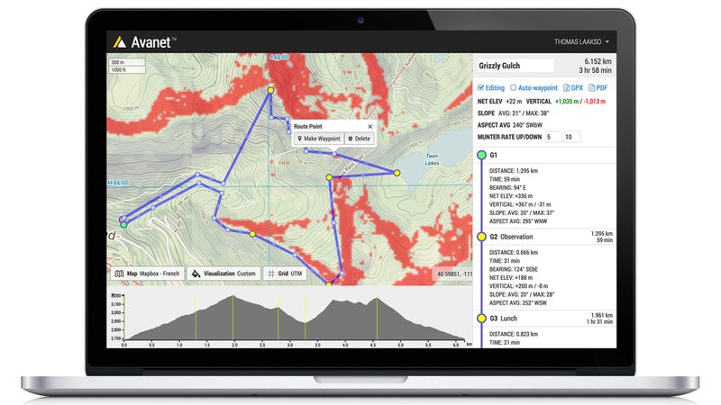
In both Tour and Pro, you drop pins on a detailed topo map using the desktop software. You can pick as many points as you like, and the software will spit out data, such as route distance and elevation gain. Even more useful are the app’s customization options. Let’s say you know from using the free version of Avanet that there have been several slides on north-facing aspects where you’re traveling. You can tell the software to keep you off north-facing slopes, and it will color-block out those areas. Next, you export that map and its data into the Avanet app on your group’s phones. Even without cell service, you can use the map with the phone’s GPS. Down the road an updated version of the app will also ping you if it detects that you’ve entered an area you specified as dangerous.
While the Avanet mobile app is new, it launched last fall for desktops; 4,000 observations have already been entered. Now that it’s available on mobile, the company expects the number of observations to grow dramatically.
Avanet is also trying to expand beyond backcountry skiing to become a resource for all mountain travelers, including alpinists, snowmobilers, and hikers. “Our goal is to keep everyone safer, while at the same time learning from the community of people who live and play in the mountains worldwide,” Markle says.