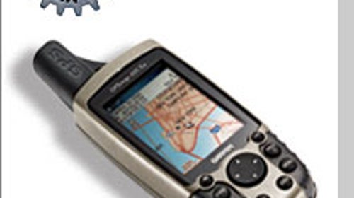

Basic navigation is available in everything from cars to phones these days, but Garmin’s palm-size powerhouse GPSmap 60CSx takes a sophisticated GPS—once found only in the hands of explorer-engineers—and puts it in every traveler’s pocket. With the unit’s intuitive interface, Garmin has simplified use for beginners while simultaneously incorporating a host of complex features that will impress veteran users. And with the longest battery life of any unit we tested, it will never leave you stranded.
Garmin GPSmap 60CSx $500
1. Screen quality matters, and the 60CSx’s 2.6-inch, 256-color LCD is best-in-show for clarity. In bright sun, the transreflective technology soaks up ambient light and channels it into the display (like an internal two-way mirror), eliminating the need to suck up battery power with the backlight.
2. The unit strikes the perfect balance between compact and capable. At just seven ounces, it’s loaded with an expandable memory (ships with a 64MB micro SD card) and deluxe features like an ultrafast processor, multiple navigation screens, a barometric altimeter, and an electronic compass.
3. The 60CSx’s battery run time is officially rated at 18 hours on two AAs—among the best on the market. Yet we managed to coax out even more time from our test unit while hiking in the Grand Canyon: After four days of almost constant use, it still had power to spare.
4. Smartly labeled buttons—easily operated with one hand, even gloved—and a Windows-like menu interface make the 60CSx a breeze to use. Within minutes of cracking the package, we were storing waypoints and creating routes for a local hike—without a single glance at the manual.
5. The Garmin MapSource topo CDs ($100) are everything that digital mapping should be: fast, easy to upload, incredibly detailed, and simple to navigate. The version we used for hiking in the Canadian Rockies included trails that didn’t even show up on other companies’ maps.