


Bayi, Tibet – Today was the first day of movement towards the gorge since arriving in Lhasa. Extreme weather conditions have delayed the arrival of the last and crucial team member, Rob Hind for five days, resulting in us having an interesting seven days exploring the monasteries and narrow streets of old Lhasa.
Mount Milha Pass, Tibet
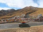 Gorge bound: up and over Mount Milha Pass
Lhasa River, Tibet
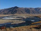 Lhasa River upstream of Lhasa
We finally left Lhasa aiming to reach the small village of Bayi, this trip would take us 195 miles and over Mount Milha Pass.
The river upstream of Lhasa became more frozen as we climbed towards the pass, eventually turning to a collection of frozen streams emerging from the arid landscape. The land here is dry, hardly vegetated, and incredibly cold, but still we drove past shepherds with herds of sheep, cows and ‘zows’ (yak-like crossbreed).
Around one corner approaching 15,000 feet, we had to dodge several monks who were busy prostrating down the main road on their way to Lhasa. Standing up, reaching high, then reaching down and sliding forward on wooden mittens until flat on the road. They would then walk their feet forward, stand up and repeat the action, each time moving only a few meters towards their destination.
At the Pass we were all breathless—at over 16000 feet we were all struggling to move with much speed, this will hopefully be the highest we will travel during the trip and everything should be downhill from here, in a manor of speaking.
On the descent we were presented with rugged snow-capped mountains in the distance, but Scott and Charley assured us that when they were there in May 1998 it had been hard to cross the pass and the surrounding land was laying under several feet of snow. As it was there was no snow on the pass and conditions were looking good.
The Gyamda River that gathered on the descent had been described as a great class-IV rafting trip with some class-V, running at around 5,000 cfs, but we drove past a dry and frozen river bed; collected waters were estimated at around 1,200 cfs. This was very exciting as this is the last major tributary of the Yarlung Tsangpo until the Po Tsangpo enters the gorge at Gompo Ne.
One hundred ninety-five miles miles and seven hours later, we drove into the village of Bayi, but we were in for a major surprise. From a distance we could see there were high-rise buildings in the area, but we were blown away as we entered the ‘city’ of Bayi. A four-lane street led around modern city blocks, high-rise glass-shrouded buildings, and extravagant city monuments until we pulled up outside a multi-story hotel. This was not quite what anyone had anticipated!
I had expected to be camping tonight! Scott described Bayi in 1998 as having a dirt road through its center, no hotels or office blocks and generality not being a very inviting place to stay. Ken Storm said that in 1993, Bayi did not really exist but was a collection of houses around a junction. Now it appears China has chosen Bayi as a key location for a new city, the buildings have appeared in the past three years and are quite empty. But things are obviously moving fast and this colorful town will surely be an alpine resort of the future, surrounded by massive mountains and pine forest.
Slightly discouraging though, Bayi stands at around 10,000 feet, and although the solid snow line is probably around 12,000 to13,000 feet it is snowing in town right now!
Tomorrow we finish our journey to Pe and the reality of the Tsangpo Gorge begins. Hopefully the morning will be bluebird and the snow line will be nice and high!