

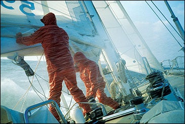
THE FIRST SQUALL HITS two minutes after we stick our nose out into Bah’a Nassau. It’s a towering, hazy thing that wobbles down the bay like a drunken ghost, standing out white against the low gray clouds. As it sweeps over us, the digital wind-speed readout in the cockpit jumps from 30 to 37 knots. We’ve got a minimal amount of sail up, just the little blade of the staysail and a quadruple-reefed main, but it’s plenty. Pelagic, a sturdy 54-foot steel-hulled cutter, heels over another ten degrees and digs her bow into a cresting wave. A sheet of foaming green seawater—whether from the Atlantic or Pacific would be hard to say—washes over the top of the doghouse. Then the shot-blasting starts: hard pellets of snow that peck at the flesh like a ravenous seabird.
Access + Resources:Around the Horn
AROUND THE HORN a 14-day charter-sailboat cruise out of Ushuaia, Argentina, typically consists of a one-week voyage south to Cape Horn followed by a second week of exploration in the glaciated fjords of the Cordillera Darwin. Skip Novak’s Pelagic takes eight passengers and costs,750 per day, per group, all-inclusive. Four-to-six-week ski and mountaineering expeditions, either to the island of South Georgia or across the Drake Passage to the Antarctic Peninsula, are also available (see Novak’s Web site: ). To get the lowdown on other charters in the area, contact Expedition Sail (603-868-2602; ). Flights from New York to Bueno…
At the helm, John Rice zips up the last two inches of his yellow foul-weather jacket and slides a pair of ski goggles over his face. A 66-year-old Englishman recently retired from a career in petroleum engineering, Rice has chartered Pelagic on an unusual quest. Along with two of his sons and two old family friends, he’s looking for a mysterious bay near Cape Horn where, in October 1875, his great-grandfather, Edmund Rice, was forced to scuttle a three-masted sailing ship called the River Boyne, for the very good reason that it was the only way to save her.
A big gust hits, driving the lee rail under. Skip Novak, Pelagic’s 50-year-old owner and skipper, comes up the companionway, looks around, and leans casually on the running backstay.
“Looks like today might be a bit of a grunt, John,” Novak says.
I can’t make out Rice’s reply, if there is one. Down below, one member of our little expedition has already barricaded himself in the head. Soon, another will emerge from the forward bunk room, looking green. He takes one unsteady step into the main cabin, then launches a stream of half-digested oatmeal in the general direction of the galley sink. Pelagic’s first mate, Rich Haworth, is stirring a pot of soup on the stove, and the projectile torrent misses his ear by an inch.
What can you say about sailing upwind in heavy weather? It isn’t everyone’s cup of tea, but today it’s ours. We’re right down at the gale-washed tip of South America, about 30 miles north of Cape Horn, heading west by southwest for Peninsula Hardy, a particularly rugged arm of the octopus-shaped Isla Hoste. Since the wind is blowing from precisely the same direction, our course is going to be one long, miserable, bow-pounding beat.
Between stints on the wheel, there’s not much to do but settle in and try to find the rhythm of it. Around the galley table, Graham Rice, 35, flips through Yachting World magazine, paying particular attention to the classifieds; someday, he says, he’d like to go into the sailboat-charter business himself. Meanwhile his younger half-brother, Gordon, 19, hunkers down for a multihour chess match with Dave Fernie, 25, while Dave’s dad, Richard, climbs up the companionway to spell his old friend John. It’s like that all day long: up, down, steer, reef, trim, soup, zip, puke. There’s not much talking, no evident father-son bonding. But slowly we claw our way up to windward.
About two in the afternoon, we tack off the north coast of Isla Grevy. Novak points out the kelpy anchorage where, one day back in the mid-1970s, the American yachtsman Hal Roth tried to secure his boat, Whisper. A 70-knot squall came in from the west and tossed the 35-foot sloop onto the rocks, severely holing her. Roth, his wife, a friend, and the photographer he’d hired to record his rounding-the-Horn experience spent nine days living under a sail before a Chilean patrol boat picked them up.
Novak’s commentary on Roth’s calamity is brief and dismissive. “Fiberglass,” he says.
At dusk, a bit of clear sky shows itself on the western horizon, and though we don’t see the sun directly, it illuminates a toothlike cordillera to the north, on Isla Navarino. I get entranced watching the squadrons of black-browed albatross as they dip and glide off the bow of the boat. No wonder the old Cape Horners revered them—they seem to thrive on the wind.
Everybody spills out on deck as we approach the high, dark silhouette of Peninsula Hardy. There’s a different mood on board now. The grim determination of the morning is gone, replaced by a quiet, sailorly satisfaction. We’re tired, cold, and windburned, but we’ve earned our way across Bahía Nassau.
All of us, I suspect, are feeling the same thing. We don’t want this to be too easy.
MANY PEOPLE IMAGINE CAPE HORN to be a fearsome finger of land extending from the tip of the South American mainland. It’s actually a small island, the southernmost of the myriad islands, islets, and rocks that constitute the archipelago of Tierra del Fuego. One does not, therefore, need to “round the Horn” to get from the South Atlantic to the South Pacific. When Magellan made his pioneering passage in 1520, he relied on a channel 250 miles to the north, and so did the next four men to sail around the world. As far as they knew, there was no passage south of the Strait of Magellan.
In 1616, Willem Schouten, an entrepreneurial Dutchman hoping to circumvent the Dutch East India Company’s “monopoly” on the Strait of Magellan, sailed south along the coast of Tierra del Fuego in search of an alternate route to the Pacific. At 55 degrees, 59 minutes south latitude—farther south than anyone had ever sailed—he found it. The turning point was a four-mile-long island whose southern aspect rose up to form a vaguely menacing promontory 1,391 feet high. Schouten named it after his home port of Hoorn, near Amsterdam.
In time, as ships grew larger and less maneuverable, bold navigators began to favor the great seaway to the south over the tight, rock-strewn confines of the Strait. That meant sailing into the heart of the Screaming 50s, the high latitudes of the Southern Ocean. There the westerlies sweep around the world unimpeded by any landmass, and the waves stack up into liquid mountain ranges—”greybeards,” the old Cape Horners called them, after their foaming crests.
Getting a square-rigged sailing ship around the tip of the continent—especially east to west, against the prevailing wind—was the ultimate test of seamanship. Such vessels could rarely “point” efficiently upwind. A crew might fight for weeks to gain some valuable sea room—distance, that is, away from the dangerous Fuegian coast—only to lose it all in a single storm. Thus the goal was not “rounding” the Horn, but “doubling” it—in other words, sailing from 50 degrees south in one ocean to 50 degrees south in the other. Only then, hundreds of miles north, could a ship be considered safely around.
Before leaving Ushuaia, the Argentine port on the Beagle Channel that is Pelagic’s base, I bought a folding map with the irresistible title “Cape Horn Shipwrecks.” On it, bright-red sinking-ship icons denote more than 150 nautical disasters, from the Orangie Boom (1643) to the Logos (1988). As we made our way south I ticked off the wrecks: Affghan, Cubana, Dreadnought, Indian Empire, Lady Prudhoe, Siam… There was poetry in those names, but unspeakable horror as well. The death tolls were sometimes fantastic. The San Telmo, with 622 on board, last seen on September 2, 1819. The O’Higgins, 1826, 506 souls…
Seventy-five of the map’s icons were lined up in neat rows south of Cape Horn, like headstones in a graveyard. Often the precise location of a ship’s demise was not known; those 75 were simply lost at sea. There were many ways it could happen. Southwest of the Horn the ocean floor jumps up from 2,200 fathoms—13,123 feet—to 55 in the space of a few miles. The result: horrendous ship-breaking seas. If a vessel’s sails were blown away, she might turn broadside, roll, and fill like a bathtub. Or, after weeks of battling the waves, her seams might open so extensively that no amount of pumping could keep her afloat. There was fire—certain cargo, especially coal, sometimes spontaneously combusted as a result of the friction generated by pounding seas—and there was ice, giant bergs drifting across the Drake Passage. But the sailor’s greatest fear was the rugged lee shore that stretches for some 200 miles northwest of Cape Horn. Driven up against it in a storm, no ship stood a chance.
Nevertheless, by the mid-19th century, the waters off Cape Horn were bustling. In 1849, the first year of the California Gold Rush, 800 ships doubled the Horn. Some of them—clipper ships like the Flying Cloud—could do it in as little as a week. The clippers were gone by the 1870s, but windjammers, often built of and rigged with iron, continued to sail around the bottom of the Americas right up until the completion of the Panama Canal, in 1914. The Ditch marked the end of the Horn as a commercial trade route, though a few stubborn Finns continued to haul Chilean nitrates by sail right up until World War II.
Military ships still double Cape Horn, and so does the occasional supertanker too big to fit through the Canal. Other than that, nobody really needs to sail around the Horn anymore. And yet they do. There are now five major around-the-world yacht races that pass south of the great capes—Africa’s Good Hope, Australia’s Leeuwin, and the Horn. Novak has raced around the Horn five times, initially in 1977’s Whitbread Round the World Race.
Aboard the Micalvi, an old naval vessel that serves as a sort of yacht club in Puerto Williams, the little navy town where we cleared into Chilean waters, we met an old Aussie pal of Novak’s, Mike Wignall, who’d just sailed in from Bluff, New Zealand. In one two-day storm, he’d faced 70-knot winds; despite dropping all his sail, he’d still had to drag warps—long lines—off the stern of his boat to slow it down. When I asked him why he’d come via the Horn instead of heading directly for his destination of Valdivia, several hundred miles up the Chilean coast, he replied, “Aw, mate, you just kinda have to, don’t you?”
The Micalvi’s logbook tells many such stories. Calling the Horn “the sailor’s Everest” may be overstating it a bit, but for ambitious mariners, rounding this small island has clearly become an important life-list experience. Which in part explains Ushuaia’s growing charter-sailboat community. Novak and his fellow skippers, most of them French, make up a small and self-selecting fraternity of very competent seamen—the rightful heirs, perhaps, of those who sailed before them.
Not everyone agrees, of course. “There is no comparison whatsoever of yachts taking tourists around Cape Horn and the sturdy commercial windjammers, who made it for a living and without the modern instruments,” sniffs Roger Ghys, a retired Belgian sea captain who is the general secretary of the International Brotherhood of Cape-Horners, an organization whose rapidly thinning ranks consist of men who actually doubled the Horn on square-rigged ships.
Fair enough, Captain. But the fact is that the Horn’s baleful glare still beckons a certain kind of sailor, who for whatever reason needs to confront the uttermost parts of the earth and the power of the sea. It probably always will.
IT’S DARK BY THE TIME WE MOTOR into the little caleta, or cove, at the end of Bahía Orange. Somewhat unnervingly, Novak remains belowdecks, deducing our location from the green shapes floating on his radar screen and occasionally calling up course corrections to the helmsman. After dinner, John Rice reminds us why we’re here: He spreads a broad chart across the galley table, passes out a few photocopies of sketches made by his great-grandfather, and, though we are all familiar with it by now, takes us through the story one more time.
Edmund Stewart Rice was born in 1842 in Workington, a little town in northern England famous for producing mariners. His father was a sea captain, as were two of his three brothers. So it was no surprise when, at age 33, Edmund was made the master of the River Boyne, a three-masted, 154-foot iron windjammer.
On July 15, 1875, the River Boyne sailed from Liverpool for Valparaíso, Chile, with 700 tons of coal. Eighty-three days later the ship cleared Cape Horn, and six days after that, on October 13, the crew noticed smoke and a strong smell of gas. Four hours later, Captain Rice logged the following entry: “1 pm smoke gaining, coming up the fore hatch in dense volumes, wind SW, hard gale increasing, deemed it advisable to batten down and run back to anchorage to E of Wollaston Island where we shall have smooth water.”
By that evening the River Boyne was smoking so heavily that it was no longer possible to go belowdecks. Rice was unable to retrieve all of his charts. Still, the next morning, as the ship approached False Cape Horn, some 35 miles west of Cape Horn itself, he managed to anchor in an unknown bay, in six fathoms of water. For the next three days, working through snow, sleet, and rainstorms, and sleeping on deck, the crew of 20 pumped and drew water on board in a vain effort to put the fire out. Sensing that the problem was more serious in the bow, Rice “set a gang to heave coals overboard out the after hatch in order to bring the ship more by the head.” More than 60 tons were jettisoned. Finally, on the morning of October 17, he gave up, realizing that the only way to save his ship was to scuttle her.
Using his anchors as grappling hooks, Rice winched the ship into the beach at a spot “abreast a stream,” and laid her aground on a falling tide. A day later, with all her ports open, the River Boyne was filled by the high tide. The fire was out, but now a new problem loomed: how to get her afloat again. Subsequent tides filled her twice more, despite the desperate pumping of the crew, but four days later the sailors finally prevailed—and the ship drifted free of the beach.
IT WAS A REMARKABLE PIECE of seamanship, and it was easy to see why Edmund Rice, upon delivering the River Boyne and its remaining cargo to Valpara’so, had been handsomely rewarded by the ship’s owners and underwriters. I could also understand why the story had been passed down through the Rice family from generation to generation, as a testament to the Ulyssean resourcefulness of the clan’s patriarch. Still, there was something that seemed unusual—or maybe just uncharacteristically sentimental—about his great-grandson’s need to “pay a little pilgrimage,” as he put it.
When I ask him about this later, John Rice, who lives in Southampton, on the English coast, can’t quite explain it. “It was the culture in my family not to make too much of it,” he tells me. “Especially because my grandfather failed to go to sea, and went into the flour-milling business instead. He always downplayed the story, and so did my father.”
“Was your father a sailor?”
“No, he was a milling engineer.”
It was Rice’s mother, Catherine, an avid dinghy sailor, who taught young John the basics of the sport, during summer vacations on the Isle of Wight. After a failed attempt at gaining entry to Sandhurst, the British equivalent of West Point, Rice earned an engineering degree and wound up spending his entire career at a giant Caltex crude-oil refinery in the Emirate of Bahrain. While raising four sons, he raced in the cruiser fleet at the Bahrain Yacht Club. He also met Richard Fernie, now 59, a South African chemical engineer for Caltex, and over the years the families of the two men often vacationed together, sometimes on chartered yachts. Later, Rice went on to earn his yacht master’s certificate from a sailing school in Devon.
One day in class, Rice told his instructor about the River Boyne, and the instructor introduced him to John Chancellor, a well-known British marine artist. In 1979 Chancellor contacted Rice and told him he wanted to depict the saga in a painting.
Rice runs his finger down the chart on the galley table and points out a bay about five miles south of where we are now—Bahía Rice. “The Admiralty named it many years ago,” he says, “and we always assumed it was the bay in which the River Boyne was scuttled.” Chancellor, Rice continues, was meticulous about getting correct detail in his paintings, and so he asked the captain of a research vessel that was doing some work in the Peninsula Hardy area to take pictures for him. But the pictures didn’t match Captain Rice’s sketches at all. Chancellor’s conclusion was that the scuttling had taken place in the next bay to the north—Schapenham.
Soon another nautical authority would weigh in. Gilles Fortineau, professor of naval history at Nantes University in France and an expert on indigenous watercraft, had originally been interested in some sketches that Captain Rice had made of Fuegian bark canoes used by the now-extinct Yahgan Indians. Subsequently, he became fascinated with the River Boyne story. Earlier that night Rice gave me a copy of one of Fortineau’s letters. It contained a closely reasoned argument about the likely site of the scuttling—the southern arm of the bay we were in, Bahía Orange—and concluded on a wildly self-congratulatory note.
“I wonder,” Fortineau wrote, “how such a meticulous man as John Chancellor could have made such a mistake…after the Admiralty! (Two mistakes! What a story!). I am a bit proud (as unknown Frenchman!) to have contributed to rectify the wrong assertions of such a famous authority and…of an admirable painter!” He signed it, “Gilles (the Sherlock Holmes of the French Navy)” and added a postscript: “It would be so nice to make a film entitled ‘River Boyne.’ You should absolutely contact Cameron, realisator of ‘Titanic’!!!!!”
Upon his retirement, in 1999, John Rice began to seriously explore the idea of an expedition to Peninsula Hardy. Many years ago he had considered retracing his great-grandfather’s voyage in its entirety, all the way from Liverpool. But chastened by a heart attack at 62, he narrowed his ambitions, got on the Internet, and found Novak, who urged him to begin the yearlong process of procuring the special zarpe, or permission, that he would need from the Chilean navy in order to visit the normally restricted Peninsula Hardy.
It’s clear that Novak has become absorbed by Rice’s quest. On the other side of the table, he’s rereading a letter that Edmund Rice sent to the River Boyne’s owners, describing the bay as “about two miles north west of Cape Lort.” That can only be Bah’a Rice. And yet the logbook describes a bay that is “well sheltered from the E by a small island in the mouth of the bay.”
“Which would seem to count out both Schapenham and Rice Bays,” Rice says, peering at a chart.
“Except that the island might not be charted,” Novak replies. “A lot of the smaller bays haven’t been updated since Fitzroy.”
“It’s a strange thing. A mystery.”
Novak nods. “Well, that’s why we’re here.”
SKIP NOVAK AND TWO RACING PALS built Pelagic in 1987, after Novak’s third Whitbread. The idea was to get off the professional-yacht-racing treadmill and see a bit more of the world. Novak, who grew up in Chicago and is now based in England, wasn’t interested in cruising the temperate zones; from the beginning he knew he wanted to go south, to the Patagonian channels, South Georgia, and above all Antarctica. Pelagic was built of steel, to withstand the ice, and equipped with a lifting keel, crucial for navigation in uncharted waters.
The keel, in effect a giant curb feeler, comes in handy this morning as we bump through the shallow passage south of Bah’a Orange. Already we’ve looked at the scuttling site identified by Sherlock Holmes, the little gap between Islas Yellow and Bullock. But it’s clearly not the right spot—too deep, and there’s no stream nearby.
Our next stop is a different story. As we inch into Bahía Schapenham, I see a great curving beach, some low, forested hills, and behind them a cirque of alpine-looking peaks and spires every bit as dramatic as that in Captain Rice’s sketch. Novak isn’t convinced, however. The stream isn’t in the right place, for one thing. And there’s a large island protecting the bay from the northeast—Isla Yellow—but no small island at all. Before he puts us ashore he wants to check out Bah’a Rice, two miles to the south. When we do, we conclude that it’s too deep, with more than 100 feet of water just off the beach.
So Schapenham it is. An hour later, having inflated a 12-foot Zodiac and dropped it over the side, we’re beachcombing, hoping for a chunk of 19th-century coal that will prove we’re right. The next morning, Novak pulls on a wetsuit and makes a brief dive, but he doesn’t find any black gold either. The rest of us hike to the top of the cirque, scuffing through a heathery gray-green landscape reminiscent of the Scottish Highlands. We kick up two grouselike game birds called tinamou, but otherwise see no living creature larger than a spider.
When we get back to the beach that afternoon, Novak is hopping with excitement. “Dear Gilles,” he says, narrating a mock letter to Fortineau. “We regret to inform you that we have concrete evidence that Schapenham Bay was indeed the site of the River Boyne’s scuttling…” While we were ashore, Novak had taken soundings from the Zodiac. Near some rocks where he thought the River Boyne would have been beached, in about ten feet of water, he’d glimpsed what looked like a number of burlap sacks lying on the bottom.
Novak moves Pelagic in by the rocks, connects a grappling hook to the shackle on the end of the spinnaker halyard, and tosses it over the side. Richard Fernie begins cranking the winch, while the rest of us bend over the side, peering into the murk. A minute later a bulky form emerges, draped in kelp like Nemo’s chest. Novak leans over the rail with a machete and hacks away at it. Sure enough, there’s a sack underneath, though it’s made of white plastic rather than the antique burlap I’m expecting. “It’s gotta be drugs,” somebody says. Novak succeeds in cutting a slit in the bag. He looks back up at us with a quizzical expression.
“It’s nylon,” he says. “Some kind of fishnet.”
(Later, a French skipper tells us the nets are for centolla, or king crab—the main cash crop in these parts. Legally, they’re supposed to be fished only with pots; hence the need for secrecy.)
Despite the red herring, I’m still convinced. We’ve scoped all three of the bays north of Punta Lort, and Schapenham is the only possibility. It does seem odd not to find a single piece of coal, considering that 60 tons were dumped overboard. Then again, that was 127 years ago. John Rice pronounces himself “reasonably certain” that we’ve found the spot, and we run the Zodiac ashore for some final documentary photos.
Novak alone seems unsatisfied. “There’s one more place I want to check,” he says after dinner. “We’ll do it tomorrow on the way to the Horn.”
AT DAWN WE WEIGH ANCHOR and motor south out of Bahía Schapenham. The barometer is at 983 millibars and falling. To the southwest, streaks of blue and pink angle up from the horizon, backlighting the fantastically jagged skyline of Isla Hermite, while behind us the northern half of the sky is a mass of angry gray clouds. An hour later, having cleared Punta Lort, we swing around into Bah’a Lort. It’s a broad bay guarded on the south by the towering cliff of Punta Cannelier. Within it lie three distinct coves, the northernmost of which—Caleta Norte, the chart calls it—is protected from the east by a small, domed island.
Gradually the cove opens before us, and with it comes an odd feeling of familiarity. John Rice gets out the sketch of the River Boyne laid on her side and we all cluster around, comparing it with the view. The mountains behind the beach don’t seem nearly as dramatic as they appear in the drawing, but there is an outcropping of whitened rocks in precisely the right spot, a few feet off the beach, and behind them a stream comes gurgling out of the hills just where it ought to. The depth is right, too—six fathoms in the middle of the cove.
Novak doesn’t even bother to look at the sketch. “This has to be it,” he says. “This is where you’d bring a ship in.”
I had argued the loudest for Bah’a Schapenham, but now I’m wondering. In his letter to the River Boyne’s owners, Edmund Rice wrote that he “came to anchor in a snug little bay about two miles north west of Cape Lort.” We are south of Punta Lort, but almost exactly two miles northwest of Punta Cannelier. Is it possible that Rice, having lost most of his charts, mistook Cannelier for Lort?
We anchor in 15 feet of water, close to the rocks. Once again Novak pulls on a wetsuit and goes over the side. Ten minutes later, he resurfaces with a couple of odd rocks that appear to be encased in a reddish coral. Haworth goes down to the forepeak, returns with an ice ax, and splits them open. They’re cement-gray inside. Novak hauls himself out of the water and shrugs.
“I still think this is the place,” he says.
When we spin the Zodiac into the beach five minutes later, I’m the first off the boat. I go about three steps before I spot a small black rock about the size of a charcoal briquette. I scratch it across a neighboring rock to see what kind of mark it leaves, and hand it to John Rice.
“There you go,” I say, trying unsuccessfully to stifle a huge grin. “The smoking gun.”
Rice hefts the lump of coal in his hand. “Well,” he says. “What do you know?”
WE LEAVE CALETA NORTE before two in the afternoon, turning south toward the open sea. The wind is freshening out of the northeast and we coast down the channel under a full main and rolled-out genoa. Half an hour later, we feel that unmistakable Southern Ocean swell “rolling along in all his majestic dignity,” as Edmund Rice put it in his log. To our left, the mighty surf dashes itself against the headlands of Isla Hermite, throwing itself 80 and 100 feet into the air.
As we clear Punta Mutis, the great headlands on the south side of Isla Hermite come into view, and beyond them a distinct pyramid that marks the southern end of the archipelago and the continent. It’s still ten miles away, a tiny blip on the horizon, but we all grab for our cameras and fire away.
“The Horn, the Horn!” Novak says, gently mocking us. We have a scant week left in our charter, and he’s anxious to get Pelagic back up to the Beagle Channel to start exploring the great glaciated fjords of the Cordillera Darwin. “I don’t understand why everybody wants to come down here,” he says, “when there’s so much stuff to see up there.”
But there’s no denying the perfection of the day, and eventually even our captain succumbs to it. The sun is out and the wind is slowly clocking around to the north-northwest. For us it means the ultimate cruiser point of sail—a broad reach—on our east-by-southeasterly run down to the Horn. An hour later it’s blowing 35, but over the aft quarter, not on the nose. It’s a downwind sleigh ride, with the rollers heaving up astern and shooting us forward. As each one passes and we dip into the trough, the bottom half of the great rock ahead disappears entirely, then comes swimming back up into view. In no time we’ve left Isla Hermite and are abreast the foaming, half-submerged rocks that lie a half-mile off the Horn—a sight that brings home the power and remoteness of the place even more than its looming cliff does.
Novak points out the spot where, in the 1982 Whitbread, his boat, Alaska Eagle, very nearly became another red icon on the “Cape Horn Shipwrecks” map. “It was blowing 50-plus and we had a poled-out jib and a reefed main on starboard tack,” he recalls. “The guy driving had no business being there, but it’s like you have to give everybody a spin going around the Horn, right? Anyway, he lost it and we jibed, all standing with the boat pinned down on its starboard rail heading straight into the land. Another guy grabbed the wheel away from him and with the help of a wave steered out of it—but we blew the mainsail in the process.”
At 5:30 in the afternoon, when we’re due south of the Horn’s jagged ramparts, Novak whacks off the neck of a champagne bottle with a winch handle, spilling a bit over the side as a libation to Neptune. About two minutes later, a giant squall blows in out of nowhere. The wind swings wildly into the southwest, the sky overhead goes black, and we find ourselves bucking through an incredibly awkward cross sea. Ten minutes after that, we round the southeastern tip of Isla Hornos. Nearby is the corrugated-metal structure where the lighthouse keeper and his family live.
Novak calls the lighthouse keeper on the VHF and, in his mangled yet serviceable Spanish, asks for the weather. There’s a long reply, and Novak puts the radio down and turns to John Rice.
“He says it’s going to shift back to the north tonight. And he wants to know if we’re landing. He’s got a few postcards up there, and you can get your passport stamped.” Novak pauses. “It’s up to you…”
Rice ponders this question for a moment, his blue eyes twinkling. I suspect that he, like me, would be happy to putter around Isla Hornos for an hour or two. If it really is the sailor’s Everest, wouldn’t it be nice to pocket a rock from its craggy shores? On the other hand, he already has his talismanic lump of coal, and he’s seen the Horn up close and from the heaving main, as a sailor should. So now, while the wind is holding fair, he agrees that Pelagic ought to roll on north in search of a snug anchorage. It seems the seamanlike thing to do.