


MY NINE-FOOT BEAR surfboard picked up speed as I dropped down the face, alone on a perfect Pacific wave at Los Cerritos Beach in Baja California Sur. The tube held for a tantalizing second, then it sectioned, crushing me into the water and breaking my leash. I found the Bear, washed up on the beach, with a nasty gash in its nose. I then did what so many before me had done when overwhelmed by Baja’s wild side: I sought refuge in Todos Santos.
Access + Resources
CLOSEST AIRPORT: Los Cabos International, 85 miles southeastGETTING THERE: Avis, Budget, Hertz, and National rent cars at the Los Cabos airport. Buses run daily from both San José del Cabo and Cabo San Lucas.
WHERE TO STAY: In town, the Todos Santos Inn (doubles, ; 011-52-612-145-0040, ) is a remodeled 19th-century hacienda with tropical gardens. At Pescadero Surf Camp (011-52-612-130-3032, ), seven miles south, stay in a poolside cabaña ( for the first person, each additional person). On site is the area’s most reliable surf shop (board rentals, per day).
WHERE TO …
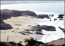
 Ah, Baja: A bird’s-eye view of Playa los Cerritos
 Nestled on the coast along the western watershed of the Sierra de la Laguna, Todos Santos has for centuries been an outlet for escapists—Jesuit missionaries fleeing angry locals, the wealthy elite of La Paz seeking release from the blistering heat and humidity on the Gulf side. In Todos Santos, a crowd is two people you don’t recognize, although the town now boasts Internet cafés, two surf shops, art galleries, and an English-language bookstore. Locals still use landmarks, not numbers, to give directions down dirt streets. Sea turtles lay their eggs on the beaches, gray whales cruise the shore, and a fishermen’s cooperative sells its daily catch on the sand that fronts the town. It’s that Baja.
Surfers have long been drawn by the half-dozen reliable breaks—like Los Cerritos, La Pastora, and San Pedrito—that begin a couple of miles north of town and extend south toward Cabo San Lucas. Now, as then, one-lane dirt tracks that angle off Mexico 19 and wind through palo verde, cacti, and mesquite spit you out on the beach. Large-scale development, however, never took hold in Todos Santos, and expat artists and writers began dribbling down newly paved Mexico 19 in the mid-eighties, attracted by the cheap hacienda rentals, the climate, the solitude, and the views—sunsets over the Pacific that radiate sky-wide; thick, briny mists that obscure the towering Sierra de la Laguna to the east; and deserted beaches stretching into the distance.
The 21st century has arrived in Todos Santos—barely. You can check your e-mail if you must, but it’s still best to leave your watch at home.
The road less Gringoed: in search of an authentic slice of paradise
 Bienvenidos a Mexico: Parras de la Fuente’s home crowd
SOUTH OF THE BORDER is where you’re bound. Mexico: desert too hot for the mind to think, ocean too blue and beautiful for the body not to fall right in.
We do it every year—my wife, Sue, whose father is from Guadalajara, and our two young daughters. We did it a month ago: decided at dinner, bought $300 tickets online that night, pulled the kids out of school in the morning. We arrived in Acapulco at midnight, rented a battered VW bug, and drove off into the sultry blackness.
This time, we went in search of what we thought might be lost: the classic gringo-free village on the beach. The place where fishermen still creak out in painted rowboats before dawn. Where there are burros wandering around in the dunes. Where a squat woman walks along the sand selling slices of homemade chocolate cake.
Several times we pulled off on rough roads, only to find that they dead-ended at tin shacks. And then we found it—down a long dirt track that wasn’t on the map, leading to a village that had changed its name. The main street of cobblestone and sand sloped straight into the ocean. The few other streets wandered pleasantly past whitewashed buildings, the door frames painted blue or green or purple or red. The clean scent of an empty sea wafted through slim palm trees.
This was the place. We knew it instantly. After driving along the coast for two days, with hot air blasting in the car while Sue tried to keep our two sweating girls occupied by teaching them nursery rhymes in Spanish, we had slipped back into enchanted Mexico.
We found a pink hotel on the edge of the village, just above the sea. We had our own tiled balcony. Downstairs was a café serving tortillas de maíz and frijoles for breakfast and whatever the fishermen brought in for dinner. The beach was immaculate, and we buried one another in powder-fine sand. Every day we boogie-boarded till the sun sank into the ocean and the mœsica Mexicana began drifting down from the café.
There are plenty of out-of-the-way villages and dead-end roads to discover in Mexico. In the pages that follow, you’ll read about six more hideaways—from the highs of the Sierra Madre to the heart of Maya country, and beyond. Bike, hike, surf, fish, and explore by day, then find a place to tune in to the setting sun. Whichever backdrop you choose, the Mexico of your dreams is still there. Go find it.
Up in the old hacienda: the mining town that time forgot
Access + Resources
CLOSEST AIRPORT: Puerto Vallarta, 40 miles westGETTING THERE: Most visitors to San Sebastián choose the 15-minute flight from Puerto Vallarta over the three-hour drive. Aero Taxis de la Bahía operates daily plane service ($80 round-trip; 011-52-322-221-1990). Or fly there and mountain bike back: Contact BikeMex ���ϳԹ���s ($220 per person, including airfare and all gear; 011-52-322-223-1680, ).
WHERE TO STAY: Hacienda Jalisco ($70 per person per night, including breakfast and dinner), a mile from the center of town, has seven rooms. Book through Pamela Thompson in Puerto Vallarta (011-52-322-223-1695; e-mail: pmt@prod-igy.net.mx). A Welsh/Canadian couple run a bed-and-breakfast r…
 The traffic is murder: marching through the thick of Novillero
ONE NIGHT AT A GALLERY opening just off Puerto Vallarta’s main drag, an older gentleman named Bud Acord overheard me whining about the sunburned Canadians taking over the city.
“Listen, I have a little hotel up in the mountains,” he told me. “You want to see Old Mexico before the tourists and developers gobble it up? Then spend a couple days in San Sebastián. Hell, it hasn’t changed in a hundred years.”
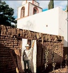
The two-and-a-half-hour drive up into the Sierra Madre to San Sebasti‡n del Oeste was on a road so rutted that my seat belt was the only thing stopping me from being propelled through the roof. As we crested the 5,500-foot ridge above the town, its whitewashed, red-tile-roofed buildings, cobblestone central square, and Spanish church looked like a mythical, forgotten city. Founded in 1605, San Sebasti‡n was once so prosperous from silver mining that at its peak in the mid-19th century the region had swelled to nearly 20,000 people. (The town now has about 600 residents.)
Though some of San Sebastían’s palatial haciendas from that time have fallen into ruin, Bud Acord saved one of them. An artist from California, Acord was among the first wave of gringos to “discover” Puerto Vallarta and its surroundings in the early sixties, when John Huston was filming The Night of the Iguana. Acord bought the Hacienda Jalisco, which dates from 1854, for next to nothing and restored the place to its original state—which means there’s still no electricity, but plenty of rustic grandeur.
That evening in the courtyard, a few other guests and I ate an extraordinary four-course dinner made with ingredients from the hacienda’s gardens. The next day I hiked to some abandoned mines with a guide. After he unsuccessfully tried to convince me to explore the pitch-black shafts, he let me in on the local lore: In the past, mine owners buried their silver to keep it safe from bandidos, saying, “When it is safe, we will return.” Of course, they never did. So the silver remains—along with much else worth seeking out.
La bicicleta tranquila: where the singletrack and vino tinto flow
Access + Resources
CLOSEST AIRPORT: Saltillo, 90 miles eastGETTING THERE: Avis, Budget, and Hertz have offices in Saltillo. Or drive the 285 miles from Laredo, Texas: Take Mexico 85 south; at Monterrey head west on Mexico 40 to the Parras-Paila Carretera turnoff. Where to stay: The Posada Santa Isabel, in the center of town near the Plaza de Armas, has a pool (doubles, $40; 011-52-842-422-0572). For resort digs with fine dining, try the Hotel Rincon del Montero, two miles north of town (doubles start at $118; 011-52-842-422-0540).
WHERE TO EAT: Carne asada reigns in Parras, and the best beef is at El Corral-n (entrees, $7; 323 Colegio Militar).
 Cruising Parras de la Fuente
PARRAS DE LA FUENTE LIES surprisingly far off the Gringo Trail for a place that’s less than a five-hour drive south of the border. Home to the 405-year-old San Lorenzo Vineyard at Casa Madero Winery—the oldest vineyard in the Americas—the town of 64,000 people is a natural oasis high in the desert state of Coahuila. Pecan trees shade the boulevards, and branches laden with pomegranates overflow into the courtyards. Wealthy industrialists from Monterrey flock here, attracted by the tranquilo atmosphere and the vino tinto. Yet the Parras I know is more fat tire than cabernet.
When I first traveled here in my uncle’s beat-up truck last April, the inclusion of my mountain bike was a lucky hunch. But the hunch paid off in the form of more than 30 miles of dusty singletrack just south of town. When I returned last August for the annual Festival of Grapes, the bike was the first thing I packed.
The morning after my arrival, I pedaled south, into the high country. Some six interconnecting singletrack circuits wind through the hills surrounding Lima Canyon. A fast, even spin took me past the Estanque Zapata, one of three local reservoirs fed by subterranean springs, near the starting point for the four-mile Ojo de Agua loop, site of a weekly cross-country race between two intensely competitive local bike teams, the Coyotes and the Raptores.
After a few small, technical climbs, I lit out through the hills, following the scree-filled trail through the sierra. By the time I’d completed a few circuits in the 90-degree sun, I was exhausted, and pedaled to the La Luz swimming hole, a palm-shaded reservoir in the shadow of the Santo Madero Church, a late-19th-century mission set on a rocky outcrop. There I met a local rider, who eyed my bike and asked if I’d be racing the next day. I nodded, “��í.”
“Que le vaya bien,” he said, grinning like a crocodile. I knew I didn’t stand a chance against the home crowd—but there’s always next time.
Get disconnected: a high-altitude sporting hub with only one line out
Access + Resources
CLOSEST AIRPORT: Oaxaca, 37 miles southwestGETTING THERE: From Oaxaca, drive east on Highway 190 to Tlacolula, north to D’az Ordaz, then turn left onto the small road to Cuajimoloyas. Contact Tierra Dentro (011-52-951-514-9284, ) for two-day all-inclusive hiking and biking tours ($85-$95).
WHERE TO STAY: The only lodge in Cuajimoloyas has four bunks to a room, showers, and flush toilets ($9 per person).
WHERE TO EAT: Food in Cuajimoloyas doesn’t stray far from comida t’pica Mexicana: Rice and beans and chicken predominate at the handful of comedores.
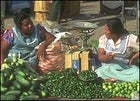 Fruit and pepper venders in Oaxaca
THERE’S ONLY ONE PHONE in the mountain village of Cuajimoloyas. It was ringing like an ambulance siren when we drove into town, so I hung my head out the window to listen for the loudspeaker announcement: “Margarita Suarez,” it echoed through the dusty roads and tapered off into the forest, “tienes una llamada….” An unconventional system, sure, but a fitting introduction to Cuajimoloyas’s other surprises—and this peaceful outpost just 37 miles northeast of Oaxaca has plenty of them. Like walking into a crumbling building to find a small fleet of dual-suspension mountain bikes (with clunky steel frames and bottom-rung componentry, but double shocks, nonetheless). Or finding out that the villagers voted a few years ago to make “ecotourism guide” an official town-government post. Or realizing that the lucky man who currently occupies that post, Joél Contreres, moonlights as a researcher for a French scientist studying the region’s enormous mushrooms. (This I learned when we were blazing down a trail and, without warning, Joél threw down his bike, dove into the trees, and popped out of the woods with a porcini bigger than my head.)
Over 10,000 feet high, with towering pines and peaks as far as you can see, Cuajimoloyas is a community of small farmers and woodworkers whose Zapotec heritage and simple pine-and-plaster structures bear few signs of Spanish influence. Cuajimoloyas and seven nearby villages constitute the Pueblos Mancomunados, a 27-year-old organization of mountain dwellers dedicated to protecting their shared forests and preserving their traditions. Tourism could be the region’s best defense, with hope hinging on the more than 60 miles of hiking and biking trails built on the former logging roads and ancient paths that connect the eight villages. All eight towns now have basic lodges where bikers, birders, and backpackers can fall asleep on a bunk and wake to the songs of warblers and the orange glow of sunlight creeping into fog-filled valleys.
On my visit to Cuajimoloyas last spring, I counted two other gringos in town, but saw no one on the trails. Joél fried up his prized mushroom for our lunch, even though it would have fetched quite a few pesos at market. I promised I’d be back, and that next time I’d bring dessert.
Time out of Maya: where the past is a blast
Access + Resources
CLOSEST AIRPORT: Mérida, 80 miles westGETTING THERE: The only regular bus service to �۲���ܲ�á runs from Mérida on Friday, Saturday, and Sunday afternoons, returning Saturday, Sunday, and Monday mornings. Those looking for a more flexible schedule can rent a car in Mérida (Alamo, Avis, and Hertz have branches at the airport).
WHERE TO STAY: �۲���ܲ�á Campamento (doubles, $35 per person per night, including three meals and a guided tour of the town and ruins; 011-52-985-858-1482, manray.csu-hayward.edu/campamento).
WHERE TO EAT: The cooks at �۲���ܲ�á Campamento provide traditional Yucatecan meals like pit-barbecued turkey with habanero sauce.
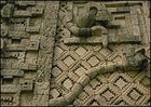 Look sharp: Mayan relief at Uxmal
FLICKERING HEADLIGHTS slice through the Yucatán night as our rented van speeds past the spiky gumbo-limbo trees and poison sumac lining the labyrinthine roads. Earlier, in the midday heat, our entourage—which included my three kids and two brothers—left the Disneyesque Maya ruins of Chichén Itzá and headed southwest into the parched hinterland. Our destination is �۲���ܲ�á, a village of a hundred thatch-topped huts where my friend David Freidel, a Southern Methodist University archaeologist, has spent more than a decade excavating a city that predates Chichén Itzá’s sixth-century temples by at least 500 years. Here, Freidel told me, life for the Yucatec Maya proceeds much as it did 15 centuries ago. At Chichén Itzá, the deserted pyramids left us wondering about the Maya’s daily life—at �۲���ܲ�á, we would witness it.
A chorus of barking dogs, touched off by a lone howl, greets us as we pull into Yaxun‡’s central plaza. A pleasant aroma of warm tortillas and smoke lingers in the night air. We see families sitting around cooking fires in pole-walled huts, while silhouettes of pigs and chickens poke their way around the dirt courtyards, fringed by avocado and banana trees. Up the street, past the 19th-century limestone church, we check into �۲���ܲ�á Campamento, a field camp that Freidel’s team of archaeologists turned over to the locals in 1996. The enterprising villagers renovated it into an eight-room inn, blending ancient Maya construction with hot showers and comfortable beds. This night, however, we choose to sleep strung up in hammocks like netted groupers.
Fueled by a breakfast of mouth-searing huevos a la Mexicana (onion-and-habanero-laced eggs) and sweet juice squeezed from green oranges, we strike off with Ceno Poot, a Maya man who has worked as an archaeologist, a cook, and, most recently, an eco-guide. Ceno leads us to the log hives of stingless black bees, which produce chardonnay-colored honey—a highlight of the Maya diet that is harvested only during full-moon ceremonies. In a recently discovered limestone cave, we crawl 45 minutes down a tunnel to find a room littered with pre-Columbian pottery shards. Later, we hike two miles along a 1,200-year-old ��������é, the raised road that once was �۲���ܲ�á’s thoroughfare to the city of Cobá, 60 miles to the east, stopping off at a sinkhole to cool off in the cobalt water.
To cap the day, we duck into the hut of a local shaman named Don Pablo. Known for both his classic Maya profile (Roman nose, sloping forehead) and his famously effective healing ceremonies (locals afflicted with everything from depression to viper bites swear by him), Don Pablo agrees to bless my daughter, Irene, motioning for her to sit in a plastic lawn chair facing sacred Maya artifacts. Tracing Irene’s aura with laurel branches, he intones 2,000-year-old prayers in conquistador Spanish. As I watch, the ritual strikes me as the consummate melding of the ancient and the contemporary, of pure Maya spirit enduring in a world of relentless change. Which is why I came to �۲���ܲ�á in the first place.
Pass the bass, por favor: a jungly sanctuary on the San Rafael River
Access + Resources
CLOSEST AIRPORT: Tampico, 100 miles southGETTING THERE: Barra del Tordo is 270 miles south of Brownsville, Texas, via Mexico 180. Bus service from Brownsville to Aldama (30 miles west of Barra) costs $26. Call ahead and someone from El Paraiso will meet you at the station.
WHERE TO STAY: A room in one of El Paraiso’s palm-log cabins, arrayed around the swimming pool, costs $95 per person per night, meals and activities included (011-52-833-213-9956, www.spagetaway.com/ gulf/paraiso/paraiso.htm). The only in-town option is the spartan Hotel Playa Azul, a two-story, 14-room hotel next to the fishing docks (doubles, $35; 011-52-833-250-1272).
WHERE TO EAT: El Paraiso, for fresh sea bass garnished with cilantro, oysters in garlic broth, or whate…
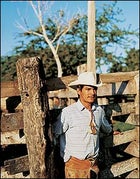 Jaguar country: the ranch at El Paraiso
DRIVE FIVE HOURS SOUTH of the border from Brownsville, Texas, and hook a left at the town of Aldama. Drive another hour east and you’ll find yourself in the fishing village of Barra del Tordo, Tamaulipas. The community is so peque-o that a thick strand of shipping rope passes for its sole speed bump. On some highway maps, Barra del Tordo doesn’t exist at all—which makes it the ideal backwater.
The village of roughly 1,000 inhabitants sits on the banks of the San Rafael River, a half-mile inland from the Gulf of Mexico. The saltwater river harbors prized snook, trout, largemouth bass, redfish, and even tarpon. Schools of grouper, snapper, ling, wahoo, and kingfish swarm the Gulf, and the sweetest oysters this side of the Apalachicola River thrive in the lagoons and inlets in between. The town’s main beach, Playa No. 2 (with showers, day shelters, picnic tables, and cooking pits) lies two miles southeast of town and is such a big nesting ground for the endangered Kemp’s ridley sea turtle that an international research station was established there in 1977. From March through August, visitors can help locate arriving ridleys and transport their eggs into the nesting corral.
But the real show begins on a rickety dock on a creek near the San Rafael, about a mile west of town. Make arrangements in advance and a wooden launch will ferry you four miles upriver to El Paraiso, a 16-room resort set on a bluff, part of a 1,000-acre ranch in a zone once known as Los Jaguares (the big cats still stalk “way back in the thicket,” or so the locals say). Wherever you look, fish are jumping out of the placid water, landing with audible plips and plops, while ospreys swoop down to pluck up dinner.
Factor in kayaking on the river; horseback riding, hiking, and mountain biking on more than 15 miles of trails around El Paraiso; and windsurfing on the Gulf (the lodge’s staff will boat you back down the river); and you may find yourself too wound up to remember the purpose of your journey. Lest you forget, you’re here to relax.