

The Dolores River��starts in the high, ancient ponderosa forests on the southwestern edge of the San Juan Mountains before making��its way to the desert, cutting through 250 million years of geology, en route to��its meets up with the Colorado River. It has��one of the longest continuous raftable sections in the country, winding through one of the most beautiful, diverse canyons in the Southwest.
But it almost never runs.����
Aside from a small section��set aside for fish habitat, nearly��all the water in the river is allocated for agriculture.��McPhee Dam, about 60 miles northwest of the Four Corners,��holds the river’s water in the second-largest reservoir in Colorado. Its availability is mostly dependent on snowmelt, and it only spills enough for people to��float in it��every three to five years, after irrigation needs have been met. Since 2000,��the river has run at 1,200 cubic feet per second (cfs)—the recommended level for floating—or more for only 131 days.��
This was one of those good years. Snowpack in the river basin was at 302 percent of its normal level��in late May, and authorities planned to open��the dam and����near��the end of the month.��I was at home��in Seattle when my friend Brad called on Tuesday, two days ahead of the��planned release, to invite me on a trip down the river. “We put in on Friday, and you should come. You can just meet us at the put-in.”
I was a 19-hour drive��away, but I’d been mythologizing those infrequent��releases in in my head. I told him I’d be there.
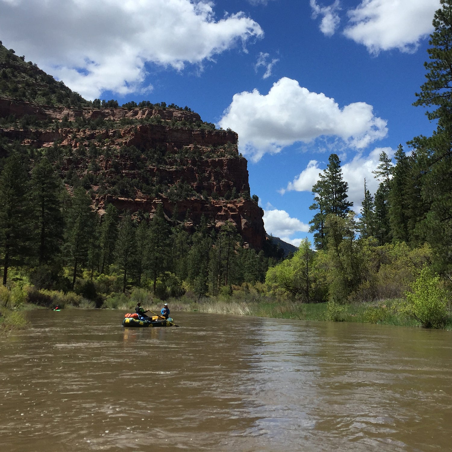
I rolled��into the Bradfield Bridge parking lot, downstream from McPhee, after midnight on Friday. In the morning, five of us pulled��up to the ramp and started yanking boats off the trailer.��
We pushed off��into the swollen channel, which was choked with coyote willows that grow thick when the river doesn’t run. Brad rowed one boat. Matt, another friend who’d been down for the last release two years ago, was at the oars of another, scouting for familiar landmarks.
The river was filled with groups ahead of us, commercial trips that had dusted off barely used permits. There were two boats of people in their eighties��from Oregon who planned to float all the way to Moab, Utah,��ten��days downstream, because they might never have the chance to do it again.
The Dolores’s rare flows are the result of a complicated mesh of storage capacity, water rights, and a variable climate.��The people who depend on the river are searching for a way to meet the needs of agriculture, conservation, and recreation while accounting for those factors. It’s a marker for the future in a hotter,��drier Southwest.��
The Dolores has been used for farming since 1889. Irrigation��became its primary purpose once the McPhee project was completed in 2000.��
for McPhee Reservoir is 229,000 acre-feet. The average inflow—the water that runs into the reservoir from snowmelt—is 327,000 acre-feet, of which 278,000 is��allocated for agriculture. That means McPhee is��essentially only big enough to serve agricultural rights. Because it’s entirely��dependent on inflow, it doesn’t have space to hold��extra water, so even in wet years, authorities can’t bank any for recreation��or research. The reservoir can only spill the extra water for recreational flows��if there’s enough precipitation.
“The [Dolores Water��Conservancy] District’s whole mission is to end the season with the reservoir at the tippy tippy top,” says Jimbo Buickerood, lands and forest protection program manager of the , an environmental advocacy group focused on the San Juan Basin. He��first paddled the river in 1973.��“It didn’t end up full in 2017, and their board members freaked out.”��For the water district, which manages the dam, a full reservoir is a safety measure and a way to make sure all the legal needs are met, but it means there’s minimal flexibility for ecological and recreational flows, especially because the basin has been in drought for the past 20 years, Buickerood says.
That’s particularly scary in years like 2018. The Dolores didn’t run at all last year, leaving��people in the region haunted by the ghost of skimpy snowfall, the fear of threatened shortages, and not enough water to go around.
“Our eyes were twitching because it was so freaky,” says Sam Carter, the program and outreach coordinator for . “And now, this year, there’s enough water to fill a reservoir that was at historic lows.” Carter, who sits on the spill committee that helps decide how much water to release and when, says this year caught them off guard, and that they’re still nervous about last year’s drought. They’re constantly at the mercy of the snowpack.
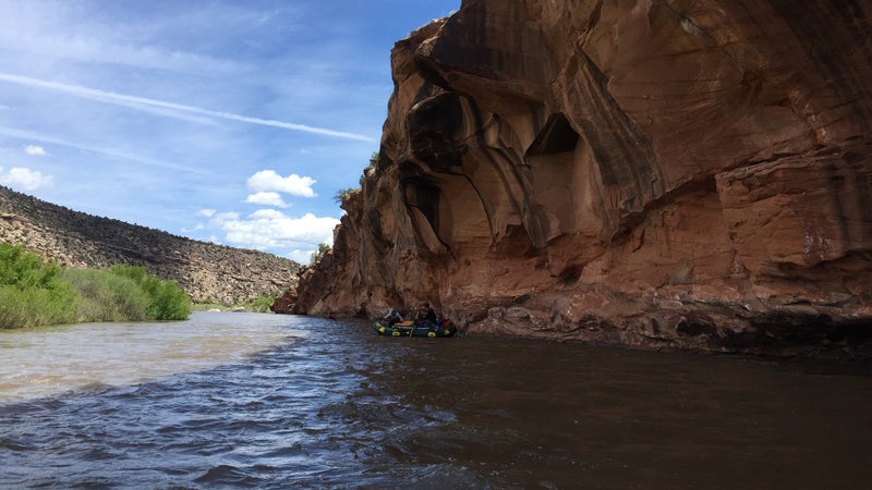
As we floated downstream,��red Wingate sandstone morphed into tan slabs of Navajo sandstone, Triassic ceding to Jurassic. Beavers popped their heads up in the eddies, and one night we set up the groover toilet next to fresh bear prints.��
The campsites and banks were overgrown with plants like invasive tamarisk, which��grows in shallow salty soil, because no one paddled through last season. That made it easy to picture��what it looks like when it’s dry and the flood regime that supports native plans doesn’t happen. You can see the human impact of a river channel with no water in it.��I wonder where the otters and beavers go when there’s only 40 cfs, the minimum fish flow, pulling through the channel. Buickerood says they’ve discovered��that cottonwood can’t regenerate when the flows are low, and willows take over, armoring the banks.
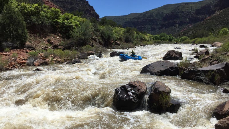
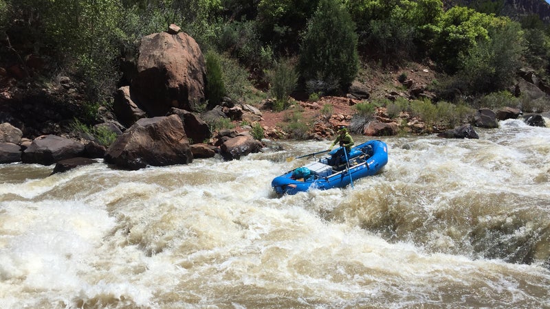
The pinnacle of paddling on the Dolores is a rapid called Snaggletooth, a long, complicated series of moves where plenty could go wrong. It has a course of screw-you rocks at the top, then a narrow slide into a fast tongue of water��between a huge hole��and a ledgy pour-over. Below that, all the water pushes toward two hooked fangs of red rock, the teeth that give the rapid its name. We scouted for a while, watching other boats run through, trying to memorize the line, picking out plan A and plan B��in case we flipped or got��stuck in the hole��or surfed sideways in the pour-over. One of the boats of older folks heading to Moab pinned on a pancake rock while we looked on.
On shore, Matt told us it boated easier than it looked, which was a small consolation as we floated toward the horizon line and the river picked up speed. Brad was on the oars. We came in river right, skated over the rocks, and caught the current, slicing the edge of the hole,��just sucking back for a second. Then we were free, and he was pushing downstream, toward the left bank, away from the toothy rocks, when I remembered to breathe again.��
Scenery, Snaggletooth,��and solitude all coalesce to make the Dolores a prime destination for rafting, but ecological integrity is part of the puzzle, too. The two are linked, and Buickerood says that, in the face of drought, pressure to maintain the ecosystem might be the most powerful tool to keep water in the river for paddlers when inflows are reduced.��
To try to account for that, and balance water rights with wildness, there have been a series of moves aimed at protecting��the corridor. They range from a Wild and Scenic recommendation in 1968, after the dam was approved, to a more recent proposal to become��a national conservation area, which Carter says would only protect the landscape, not the water, because flows are still beholden to the irrigation water rights, even if the land is protected.
This year, even though the snowpack was high, runoff was slow, thanks to a cold spring. The spill committee was cautious about when to release water. Buickerood says a lot of those decisions have historically happened out of fear.
The , a stakeholder group started in the early 2000s, is trying to get more flows for fish and more flexibility. It��sets recommendations for how to use excess water (when there is any),��and Carter says it��brings in all of the river’s constituents, from irrigators to stream ecologists, to try and��figure out how to use the river for the most purposes. Endangered fish are a big lever, as is the desire to maintain and manage the river corridor, all of which take water.��
This year’s levels were��abnormally high. By the time we got off the river, three days later, snowpack was at more than 1,000 percent of the average.��That’s what climate change is—inconsistencies in the systems we depend on. The future of the Dolores is a complex question:��How do we plan for a variable future and avoid one where��decreased flows potentially pit agriculture against environmental concerns or recreation?
“My answer to that��question is building relationships.��The biggest piece is communication,” Carter says.
As the Southwest dries out—and nearly ��that it will—I don’t want river trips to be freak pilgrimages that feel like last glances at a fragile, fading slice of a natural system we used to know. I’m glad I came, I’m glad I saw it, but I don’t want this swollen water year to be the last time I do.