

RENOWNED UNDERWATER cave explorer and filmmaker Wes Skiles has twisted his way through hundreds of miles of submerged passageways over the past 30 years, but to make Water’s Journey: Hidden Rivers of Florida, a documentary that airs this October on PBS, he needed a new tool.
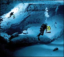
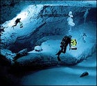 Down Under: 260 feet below the surface in the Floridian Aquifer
“We wanted to demonstrate how surface pollution can contaminate drinking water,” says Skiles, a 45-year-old Florida native. “To do this, we needed to present hard proof in a dramatic way.”
Water’s Journey follows cave divers through the Floridan Aquifer, a vast network of saturated limestone underlying Florida and southern Georgia that includes up to 1,000 miles of swimmable tunnels. Though the labyrinth has been explored for decades, the persistence of archaic survey techniques has led to only rudimentary maps. If Skiles was going to deliver a solid environmental punch, the film had to clearly connect aboveground pollution to the hidden waterways below.
Enter Brian Pease, a 60-year-old retired Navy electronics engineer who used technology similar to that in avalanche transceivers to develop a new tracking system that allowed surface teams to precisely monitor divers through hundreds of feet of rock. Before this, the best systems could only identify static locators that had to be tediously placed in caves. With Pease’s invention, a diver carries a footlong antenna that emits a magnetic field. On the surface, a tracker detects the field with a laptop-size receiver that gives off an audible hum, then goes silent when it crosses directly over the diver. Putting it to work allowed surface crews to follow along above divers as they swam routes linking residential wells with passages underlying parking lots, construction zones, and other sites that can potentially leach toxic runoff into the aquifer through its porous ceiling. “This totally revolutionizes cave mapping,” says Jill Heinerth, 38, a veteran cave diver with Skiles’s High Springs, Florida–based Karst Productions. “What used to take years can start coming together in a single dive.”
Near the end of filming, Pease combined a diving radio with technology closely related to the tracking system’s, allowing cave divers to speak with ground teams. The payoff? Improved safety and the ability to direct divers into corridors passing under surface features.
“We don’t even understand the potential of all this,” says Skiles. “We haven’t begun using our imaginations yet.”