

The weather reports from the top of the world last summer were not good. Miles of sea ice went missing in the Arctic Ocean. Biologists warned that polar bears would soon have no place to live. The 170-square-mile Ward Hunt Ice Shelf, at the northern end of Ellesmere Island, broke apart for the first time in thousands of years. And 950 miles south of the North Pole, off northwestern Greenland, the U.S. Coast Guard’s newest and largest icebreaker, the Healy, was having trouble finding any ice to break at all.
Northwest Passage, the Arctic
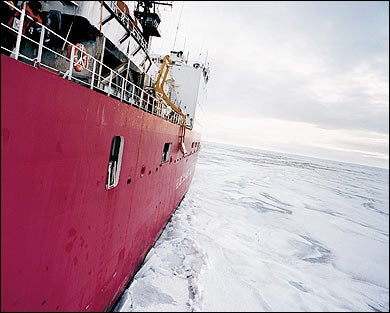
 The USCGC Healy navigates the Beaufort Sea
Northwest Passage, the Arctic
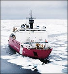
 The Northern Passage, as navigated by the USCGC Healy, August 19-30, 2003
Northwest Passage, the Arctic
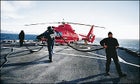 MISSION ACCOMPLISHED: the ice-recon chopper at rest on the tarmac.
Northwest Passage, the Arctic
 CRACK-UP:”extremely lame conditions” on the Beaufort Sea
Northwest Passage, the Arctic
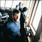 THE ICE STARE: Yves Sivret surveys the scene from the bridge.
It was August in this lonely corner of the Arctic Ocean, and the iceboat’s chief, Captain Daniel K. Oliver, picked up his binoculars and took in the view from the Healy‘s bridge. There was not much to report in the way of upcoming hazards. We were surrounded by deep blue sea.
During routine ice-breaking, there is usually a lot to do on the Healy—scrutinizing satellite images for ice migration, replotting the ship’s course, crushing big chunks into smaller chunks—but absent the frozen obstacle course, life on board slowed down considerably. The 92 members of the crew piled too much food on their trays from the all-you-can-eat buffet and wandered the floors. Even the announcements broadcast over the shipwide intercom grew lethargic. Instead of “Attention, all hands! Following is a test of the flight-crash alarm!” or “Secure all doors and hatches!” we got “Now, all hands! There will be a morale skeet shoot at fifteen hundred on the flight deck.” And “Now, for the attention of all hands, there will be a pudding-eating contest on the mess deck.”
Not that the Healy eschews diversions: For example, there are Polar Bear initiation rites (in which “Bluenoses”—Arctic first-timers—prove their mettle by swimming in frigid water) and Ice Liberty (a few hours of shore leave on an ice floe during which each Coastie is allotted a ration of two beers). But the lack of any kind of ice whatsoever made even boozing on a berg—or any other ice-related fun—impossible.
The Healy had just departed the harbor of the U.S. Air Force’s Thule Air Base, in Greenland, and was sailing to its next assignment, in the Beaufort Sea, north of Alaska. The ship was going to smash through the 900-mile-long Northwest Passage from the Atlantic to the Pacific. The only other time the Healy accomplished this was on its maiden voyage, in July 2000—a test to see whether this behemoth ice-breaking machine could survive the waterway.
Built with state-of-the-art laboratories and sonar mapping systems, the four-year-old, 420-foot, 16,000-ton, $350 million Coast Guard icebreaker was designed to be a platform for Arctic exploration. The ship’s crew regularly hosts visiting research teams who do everything from collecting water samples to monitoring how clams survive on the polar seafloor. Although no extensive experiments were planned for this voyage, scientists—like Dave Monahan, director of ocean mapping for the Canadian Hydrographic Service, who was on board to map spots on the passage’s seafloor that have remained blank on nautical charts for 500 years—would be gathering anecdotal information.
As the Healy cruised through calm seas, Captain Oliver, a soft-spoken 46-year-old from California, underlined the fact that, on a calm day like today, even a yacht would be able to sail unhindered to the Alert radar station—the Canadian Forces’ acoustic surveillance facility about 400 miles away on the tip of Ellesmere Island and the northernmost permanently inhabited spot in the world.
“Don’t forget: The Alert station is named after the HMS Alert, a steamship that got up that far in 1876,” the captain said. “Back in the 19th century, when they didn’t even have icebreakers, a lot of navigators made it up to Alert, because there was open water.”
The captain was making an important point: If wooden schooners could sail that far more than a hundred years ago, then the recent disappearance of Arctic ice might be the result of the earth’s naturally cyclical climate, rather than human-induced global warming. Blame Mother Nature or human nature, but my mission was the same: to conquer the passage and jump ship when the boat arrived at Barrow, Alaska, 14 days later.
– On the bridge, Captain Oliver set down his binoculars. “Six weeks ago, I suspect, there would have been so much ice, we wouldn’t have been able to cross the Northwest Passage.”
THE NORTHWEST PASSAGE—a labyrinth that runs from Greenland to Alaska around 90 major and some 30,000 minor islands—has always been a Holy Grail-cum-icy death trap for mariners. As far back as Columbus, cartographers dreamed of a quick maritime route to the Orient from Europe. Often they drew the mythical strait on their maps without knowing its exact location.
Naturally, this raised expectations. In 1497, explorer John Cabot sailed as far as the southeastern shore of what is now Canada and claimed it for England. He was followed by such single-minded British adventurers as Henry Hudson, who was left to drift in a small dinghy—in the same bay that bears his name today—during a 1610 mutiny on his fourth attempt to find the passage. By the mid-1800s, the quest for a shipping shortcut had crystallized around the Parry Channel, an 800-mile deep-water route from Baffin Bay to McClure Strait, just east of the Beaufort Sea, named after the British naval explorer Sir William Parry.
The search for an Arctic thruway became a worldwide obsession. In 1845, when the ice swallowed up British rear admiral Sir John Franklin’s ships Erebus and Terror, along with 133 crewmen, newspaper accounts of the tragedy inspired 40 separate rescue expeditions. Historians credit Royal Navy captain Robert McClure, who, between 1850 and 1853, sailed all but 200 miles of the route (and walked and sledded the rest of the way) with the first traverse by a European. But it wasn’t until 1906 that Norwegian explorer Roald Amundsen, the first man to reach the South Pole, finally accomplished the first complete ocean-to-ocean transit. With Amundsen’s success, and the completion of the Panama Canal in 1914, the obsession ran its course. Nearly a century later, fewer than 5,000 people have made it all the way through.
If it weren’t for the fact that recent NASA satellite data showed Arctic ice coverage to be shrinking, shipping magnates, government officials, and political scientists would probably still be ignoring the Northwest Passage. But the lack of ice has rekindled interest. A viable route through the Arctic could save time and money; from Europe to Japan, it’s 6,000 miles shorter than the Panama Canal route.
This only causes headaches for Canada, whose government sees the Northwest Passage as a proprietary waterway, as Canadian as Lake Winnipeg. The United States and Europe—relying on the United Nations’ International Law of the Sea definition of an “international strait” as a body of water that connects two oceans—view the passage as the world’s property. In 1969, the SS Manhattan, a tanker in the Humble Oil and Refining Company fleet, crossed the Northwest Passage without asking our northern neighbor’s permission. Even though Canadian politicians objected vociferously, Ottawa provided two icebreaker escorts that helped free the American ship from 25 separate jams. Nowadays, the U.S. State Department notifies Canada of American icebreaker travel plans, and Canada responds by “granting permission” that the U.S. never asked for in the first place.
In diplomatic terms, you could call this a stalemate. According to Morris Maduro, a political-science professor at the University of Alberta, “in five years the passage will be navigable in summer, and in ten years, the winter. This will be one of the hottest issues dividing Canada from the U.S.” That seems slightly alarmist. But as defense analyst Rob Huebert, associate director of the University of Calgary’s Center for Military and Strategic Studies, points out, Canada is not prepared to handle the environmental disasters, mass tourism, maritime accidents, potential terrorist activity, and contraband smuggling that a new Canada Canal could entail. As sea ice recedes, he told me, “America’s back door swings wide open.”
More worrisome is the fact that only 150 full-time Canadian soldiers are guarding the 2.5 million square miles that constitute the northern areas of Nunavut, the Northwest Territories, and the Yukon Territory. There are also a few thousand volunteer Canadian Rangers—aboriginal reservists equipped with World War I-era Enfield rifles. As Colonel Norris Pettis, commander of the Canadian Forces Northern Area, tried to reassure me, the rangers serve as the nation’s “eyes and ears in the middle of nowhere.” When I asked a spokesman in Canada’s Department of National Defense how the military is readying for an open Northwest Passage, I received a release stating that an Arctic Capabilities Study recommended “slightly increasing the number of personnel” and providing the Inuit rangers with “GPS systems, radios, binoculars, and camping equipment.”
To be fair, there are other organizations (the Canadian Coast Guard and the Canadian Air Force, for instance) watching the Arctic. But even Gary Sidock, director of operational services for the Canadian Coast Guard’s Central and Arctic region, conceded that such surveillance will never be enough.
“Can I tell you there is a picket fence around Canada? No,” Sidock told me. “The Arctic is an easy place to hide in—but you have to get there first. And it’s an isolated and inaccessible spot.”
UNLIKE FRESHWATER ICEBERGS, sea ice is not romantic. It is neither majestic nor soaring. It does not give off that otherworldly spectral glow of pure whiteness born of glacial snow. Its verticality does not threaten ocean liners with a predatory, awe-inspiring loom. It is not prehistoric in origin. Quite the contrary: Most sea ice is younger than a decade. It is flat and flawed. It is often pockmarked, dirty with algae, and lumpy with protruding hummocks. It forms into small pizzas, called “pancake ice,” and coagulates into larger 60-foot disks, called “ice cakes.” It sets into mile-long floes that crash into one another, forming uneven bands of “ice ridges” that can grow into heaps ten feet tall and harden like a scab over a wound. And when summer temperatures degrade the ice, it is dismissed as “rotten.”
Even so, polar ice is menacing. It can be as crumbly as a saltine one minute and as hard as anthracite the next. If its pressurized floes are thick and unbroken, it can stop an icebreaker dead or slice the steel hull of a lesser ship like a can opener. And just like all things harsh and unpredictable and carnivorous, Arctic ice is easy to fall in love with.
But for the first few days after the Healy chugged away from Thule, there wasn’t any.
Sure, there were a few picturesquely clichéd glacial icebergs vamping it up in the vast open expanse of Baffin Bay, but none of the saltwater ice in question. And 300 miles west of Thule, when the Healy crossed into the narrows of Lancaster Sound, the official entrance to the Northwest Passage, there was nothing but water.
Unlike freshwater glaciers, which freeze at 32 degrees Fahrenheit, the salinity of seawater requires 28.8 degrees to freeze. So sea-ice melt serves as an early warning system for the earth’s climate; less ice means air and ocean temperatures are heating up. In that sense, the Arctic is a litmus test of climate change.
In August 2000, a front-page article in The New York Times interpreted the “first” sighting of open water at the North Pole in perhaps “more than 50 million years” as “evidence that global warming may be real and already affecting climate.” In an April 2001 report titled “Naval Operations in an Ice-Free Arctic,” the U.S. Office of Naval Research stated that over the last quarter-century, “submarine data reveal a 40 percent decrease in Arctic sea ice volume,” and satellite data “demonstrate a decrease in sea ice extent of 3 percent per decade.”
The old Arctic hands on the Healy didn’t seem overly concerned. Yes, the ice coverage had recently shrunk somewhat, they said, but a lot of ice was simply being blown into other sections of the passage, clogging it up and making it harder to navigate. On a lower deck, in one of the ship’s cavernous lab spaces, 59-year-old Dave Monahan talked to me about the passage’s current state as he monitored a computer that, every few seconds, recorded time, date, water depth, and ship’s location. Hardly anyone ever asks his Hydrographic Service for an official map of the area, he said. Ice or no ice, he believed that the waterway remained too dangerous to be a commercial route.
“The good news is, the chances of crashing into another vessel up here are rather small,” Monahan told me, laughing at his own understatement. “The bad news is that we haven’t mapped all the shoals in the Northwest Passage by a long shot. We don’t know the tides and currents. There are no navigational aids, like lighthouses or buoys, nobody and nothing to help you if your radar goes down. There’s dense fog. And then, of course, there’s always the ice, the ice, the ice.”
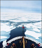
One afternoon, six days into our journey, as I paced my spartan cabin and looked longingly out the tiny porthole, the Arctic finally began to live up to its reputation. First, by the barren shores of Bathurst Island, a few chunks of ice drifted by like albino lily pads. Then came a few ice pizzas. Then a floating football field appeared, its ragged and ruffled ridges indicating a considerable keel. Crashing into it felt like a 3 on the Richter scale.
The cylindrically hulled Healy drove up on top of the massive floe until the heft of the boat sent dozens of cracks spidering across the surface. The floe split and hunks the size of double-decker buses cleaved off, some bouncing along the ship’s flanks as it plowed through, others flipping over helplessly, exposing their baby-blue underbellies as if they were giving up and crying uncle.
In previous centuries, when Arctic explorers looking for the Northwest Passage got mired in ice, they had very few options. They drifted wherever the floes took them or threw ropes down and ordered crews to haul the ship by hand into the nearest open channel, a procedure called “warping.” Or they abandoned ship altogether and slogged to shore, hoping to regain their vessels when the ice thawed. More often, they watched with dread as the ice ground their schooners to sawdust. The wrecks later washed ashore on the passage’s uninhabited islands, which are still littered with the bones of stranded sailors cannibalized by their frostbitten, scurvy-crazed compatriots.
None of this befell the Healy. Instead, one of the ice pilots simply gunned the throttle and sped up.
IN 1903, THE FIRST YEAR of what would be a three-year crossing of the Northwest Passage, Roald Amundsen wrote that ice conditions “had been unusually favorable. We had made headway with ease… As far as we could judge, the year 1903 must have been a very favorable one as regards ice.”
Amundsen’s accounts, as well as those of British naval explorers—such as Sir James Clark Ross, who discovered the location of the magnetic North Pole in 1831—used to be consulted by Arctic adventurers looking for pertinent navigational tips. But recently, scientists have started reading these explorers’ logs to look for clues about environmental change. Kevin Wood, the Knauss Marine Policy Fellow at the U.S. National Oceanic and Atmospheric Administration, spent the past year using the data on ice extent, ice thickness, melt and freeze dates, along with temperatures recorded by 44 Arctic expeditions, to reconstruct the polar climate during the 1800s. In a recent issue of the geophysics journal Eos, Wood and co-author James Overland concluded that “19th-century explorers did not usually encounter more formidable ice than explorers in the 20th century.”
Wandering around the Healy‘s decks, in balmy 20-degree temperatures, carrying the leather-bound tomes of one 19th-century explorer or another, Wood, a 41-year-old climatologist, scrutinized the occasional glaciated island as it went by and compared it with explorers’ descriptions from previous centuries. The book he was reading when the Healy first hit the ice was The Voyage of the Fox in the Arctic Seas, by Captain Francis McClintock, who wrote in 1860 that he was astonished by “the total absence of ice in Barrow Strait. I was here at this time in 1854—still frozen up—and doubts were entertained as to the possibility of escape.” In other words, radical climate change is not just a modern phenomenon; it’s also a historical feature of the passage. Wood put it this way: “Based on 19th-century material in which explorers encountered extreme ice variability and ran into both warm seasons and cold seasons, I don’t see anything surprising here.”
Wood isn’t the only one looking to the past for answers. Using two centuries’ worth of temperature and ice records from Russian, U.S., and Canadian archives, Igor Polyakov, a physical oceanographer at the International Arctic Research Center of the University of Alaska, has come to a similar conclusion.
“The ice was thick in the 1920s, thin in the 1930s and 1940s, thick again in the 1960s and 1970s, and thinner in recent decades,” Polyakov told me from his office in Fairbanks. “Our research shows that a big portion of the changes we are seeing are due to a cycle of multi-decade variability. Any prediction here would be speculative, but I can advise people not to throw out their winter clothes.”
I was glad I took his advice. Several nights later, the view from the bridge looked as if we’d landed on the moon. A thick white crust stretched all the way to the horizon. The uneven topography alternated between blocks of ice mesas, deep ice craters, bony ice ridges, and rolling ice dunes glowing an otherworldly sapphire-blue.
An announcement came over the intercom: “QM1 Grob has the conn.” This meant that the floes were so thick that Quarter Master Dave Grob, a 35-year-old Arizonan with wire-rimmed glasses and trim brown hair, had been dispatched 106 feet above sea level to the aloft conning tower to steer the ship through the hazardous maze. The glassed-in ice pilot’s tower is the modern-day equivalent of a crow’s nest, three vertical ladders above the bridge. Grob was giddy as hell up there, because the gnarly floes offered a rare challenge to a jaded ice-breaker.
“Did you see the size of that chunk?” he asked me once I’d shimmied up the ladders and into the conn. “It’s awesome!”
In the ten years Grob has been with the Coast Guard, he’s worked on patrol boats in Florida and scuba-dived under the North Pole, but piloting an iceboat still gets his adrenaline pumping. Off the starboard, he pondered a field of primordially crusty, mustard-colored ice. It gave him the willies.
“You got to wonder about the history of that ice, where it came from and what those old explorers felt like,” he said, turning on the searchlights and beaming them at a ridged wall ahead of us, at 11 o’clock. He had no choice but to plow into it head-on. Small pieces cracked off, but a huge chunk stayed intact and the Healy teetered slowly up and down while the Doppler Speed Log—the naval equivalent of a speedometer—steadily dropped.
Grob eyed the floe, estimating its strength. Then he flipped on an additional engine and revved it up. The ice finally cracked and the ship was free. “Ice-breaking is like driving an SUV,” he said. “It’s smoother on the road, but it’s made for extreme terrain. Like all off-roading, it’s man and machine versus nature. But you still have to be careful, or nature wins.”
IT’S SAFE TO SAY that most humans will never experience the hazards of the Northwest Passage. But Captain Oliver had navigated through here in 2000, and now, ten days into our journey and about 600 miles into the passage, with satellite images showing miles of impassable frozen sea between 20 and 30 feet thick, he wasn’t going to let a few ice cubes stop him.
We were in Viscount Melville Sound, where, in 1819, Sir William Parry and his crew got stuck in the ice. They ducked into a bay he dubbed Winter Harbour and waited for the spring thaw. The Healy was far better equipped to handle dicey situations than a wooden sloop, but the harsh Arctic environment still made stranding a possibility.
The captain dispatched Yves Sivret, a 40-year-old ice ace on loan from the Canadian Ice Service, to go out with the ship’s regular ice-reconnaissance helicopter team and have a look. The hope was that Sivret, a specialist in aerial ice analysis, would spot flaws in the floes and find a way out.
Hovering at 1,500 feet in the chopper, the blocked entrance to McClure Strait in sight, Sivret sweated through his padded neon-orange survival suit and stroked his Viking beard. An icefield the size of New York’s Central Park butted up against another one the size of the Washington Mall. Even more problematic than the floes’ extensive reaches were their high ridges and eerie turquoise glow—indications that this was solid pack ice that could bog down and ensnare the icebreaker.
“Can we go higher?” he asked the pilot, Gary Naus, who pushed the helicopter up to 3,000 feet.
Every few minutes, flight mechanic Ray O’Dell radioed the ship with the exact amount of time left before “splash”—the moment the helicopter would run out of gas and drop into the Arctic Ocean.
“Five-zero to splash,” O’Dell informed the mother ship.
“Splash?” Sivret said. “It’s more like five-zero to splat, with ice this thick out there!”
Such thick ice seemed to call into question the 40 percent decrease in Arctic ice thickness quoted in the U.S. Navy study. As Dennis Conlon, the author of the report, later told me, “None of those submarine measurements pertain to your area of interest,” because those subs never traveled through the passage to begin with.
Some scientists even dispute the importance of the 40 percent decrease the submarines reported in the higher latitudes. Greg Holloway, a polar expert at Canada’s Institute of Ocean Science, points out that “the ice may have been 40 percent thinner in the few locations that the submarines went, but it wasn’t that much thinner Arctic-wide. It was probably even 40 percent thicker in other sections of the Arctic. There is a big variability in ice from year to year due to wind and temperature. Most of the ice was still there. It just moved around.”
I had come north to see ice, and now I was seeing how bad it could get. Earlier in the summer, on a quest to row a collapsible rubber boat solo across the Northwest Passage, Dom Mee, a former British marine commando and ocean rower, experienced the same kind of here-today-gone-tomorrow phenomenon. The ice got so bad that he was ultimately trapped for three days, only 35 miles from his destination at Victory Bay, on Baffin Island, and forced to abandon the trip, which he later described as “absolute hell.”
From his heli-perch above Melville Sound, Sivret spotted a variation in the ice plates a few miles away. On closer inspection, he zeroed in on a patchwork of pale colors—gray chunks the size of city blocks whose dullness indicated weak “first-year” ice, thin floes that formed last summer and, having survived another August, would age into thicker “multiyear” ice. Here and there, he could see a few pools of open water. He turned to pilot Naus and said, “Tell the captain the bad news is there’s miles of multiyear ice. The good news is we can go around it to the southeast.”
The ice recon completed, the chopper headed back to the Healy with “three-zero to splash.” In the flight hangar, Sivret stripped off his survival suit. Underneath, his light-blue oxford was soaked, proving that the Northwest Passage could still make a sea hound sweat.
“I’m going to brief the captain,” he said. “But first I’m going to change my shirt.”
That’s the trouble with ice: It’s unpredictable. When it comes out of nowhere and surrounds you, threatening to hold you hostage for the winter, your first priority is to get away from it. And when it vanishes unexpectedly and you’re back in the safe monotony of open water, you miss its jagged menace.
Being on the Healy as it picked its way through the Northwest Passage was like going to a summer camp where the strangers you meet on the first day become your best friends. Though the camaraderie would remain, the awe-inspiring ice responsible for bonding us Bluenoses with the crew disappeared as we sailed out of the passage and into the slate-colored chop of Alaska’s Beaufort Sea. Being iceless again was a letdown. But at least I had managed to document some mammoth floes, however many—or few—of them are left.
That Arctic sea ice, as recorded by NASA satellites, has decreased by about 3 percent per decade over the past 30 years is a fact that many climate researchers acknowledge. But it’s about the only thing they can agree on. They disagree on whether the warming trend is permanent or temporary, earth-shattering or a minor blip on a millennial time scale, naturally geothermal or artificially human-induced. That’s why, ten days after The New York Times ran its August 2000 front-page story under the headline “Ages-Old Icecap at North Pole Is Now Liquid, Scientists Find,” the newspaper was compelled to run a correction, and its reporter, John Noble Wilford, wrote a follow-up piece headlined “Open Water at Pole Is Not Surprising, Experts Say.”
“When there has been an ice decrease in one piece of the Arctic, people make the leap that the decrease correlates to the entire Canadian archipelago,” says John Falkingham, director of ice forecasting at the Canadian Ice Service. “But we don’t have any data to support this, because there is no systematic observation of glaciers and ice shelves in the north.”
The Arctic’s erratic behavior is one of its charms, but that same ineffability is what makes it hard for scientists—or, for that matter, governments and political analysts—to come to conclusions. Scientists point out that those talking heads who claim the Northwest Passage is about to be ice-free year-round are neglecting the fact that the near-total lack of sunlight between October and March means that, barring a realignment of the solar system or catastrophic global warming, winter will always freeze the Arctic. Which is another way of saying that North America’s back door is not wide open, though it certainly may be ajar.
“We have a very poor understanding of the Arctic,” says John Stone, executive director for climate change at Environment Canada, the government science ministry. “There are disturbing warning signs, and you cannot ignore them. But we don’t have enough data right now. The only thing we can be sure of in the Arctic is that we are in for more surprises.”
The surprise when the Healy entered the Beaufort Sea was that, once again, we couldn’t find any ice to party on. The normally stoical voice reverberating over the Healy‘s intercom system could not mask its disappointment. “Attention, all hands! Due to extremely lame ice conditions, Ice Liberty has been canceled.”
Unlike hundreds of their predecessors, the crew had successfully weathered the legendary passage and its predatory ice. But, a hundred years after Amundsen, the journey ended without a triumphal on-ice celebration.
As the Healy‘s helicopter carried me to the permafrosted dust bowl of Barrow, my last impression was this: Arctic ice is like a polar bear—sometimes it vanishes into the landscape, and sometimes, just when you let your guard down, it materializes out of nowhere, brandishing its deadly white teeth.