We awoke to the sound of driving wind and blowing snow battering the walls of the tent. It wasn’t the kind of storm that made you start scratching out a will on the side of your water bottle, but unzipping the tent door a crack and getting blasted by spindrift did make us second guess our plan to make a move to Camp 2.
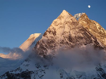
We’d left base camp the day before at 6 a.m. on an absolutely splitter day; cold and clear, not a breath of wind. We followed the Koreans’ path across the glacier towards their Advanced Base Camp on the Abruzzi Spur, but hung a left after crossing the South Face avy plain and before we reached the ice field. This took us to the base of the south-southeast spur, known as the Cesen Route after Tomo Cesen soloed it in 1986. There are also a handful of climbers who refer to it as the Basque Route, but it’s unclear whether this is because they question the veracity of Cesen’s achievement or because it was a Basque team that was the first to climb the route to the summit. Then again, if you ask Andy Parkin he’ll tell you that his crew climbed it before any of those guys but didn’t claim it because they didn’t reach the summit either. As Andy points out, “You can work a route all y’like, but if you don’t reach the top, it’s not your route, is it?” All philosophical discussion aside, Frippe calls it the Cesen, and I met Tomo in Chamonix a couple of years ago, and he seems like a nice enough guy, so for this story let’s call it the Cesen Route.
The Cesen is a bit more difficult than the Abruzzi, which, on a mountain like K2, is reason enough that the Abruzzi gets 80 percent of the traffic. But the Cesen is also the only line on the mountain that a skier will look at and envision a complete descent from summit to base. Which, of course, is why we’re here, crouched inside our tent, wondering whether we should roll the dice and continue up or gather our toys and run home in time for dinner.
Many climbers invest thousands of well-spent dollars to procure daily, customized weather forecasts from meteorologists who specialize in weather reports for climbers. Arguably, their services have changed the high-alpine climbing game more than any other technical development in the past 30 years, dramatically reducing death and injury by giving climbers a more accurate picture of when to charge and when to kick back at Baltoro base camp.
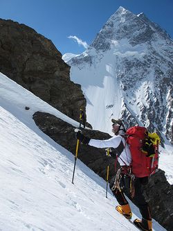
Once we’d battled our way outside and shoveled out the tent, the mountain actually looked like it might have a chance of clearing. However, our forecast predicted snow starting up that afternoon and continuing through the next day. Decision time. Since we were only at C1 and it was still early in the game, we decided to pull our chips. If our instincts were right, we’d be back up the mountain in a couple of days with a weather window that would allow us a shot at Camp 2. There really wasn’t anything to lose.
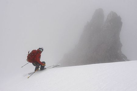
As we battened down the hatches on C1, the weather gradually worsened, and by the time Frippe had locked into his skis, we were engulfed by fog. What he had hoped would be a fun shred down 40-45-degree slopes back to the base of the route turned out to be a slow, route-finding mission. It was a mission that, in the end, would validate our conservative decision.
–Trey Cook
To learn more of Fredrik Ericsson’s past expeditions and about his quest to ski the world’s three highest mountains, go to .