ϳԹ

Image
(Illustration: Antoine Maillard)
Image
Abandoned trails—enthusiasts call them phantom trails or ghost trails—are ubiquitous in Acadia. (Illustration: Antoine Maillard)

The Ghost Trail Hunters of Mount Desert Island


Published:  Updated: 

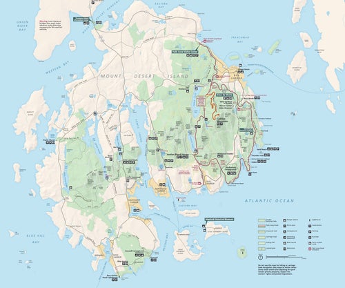
Acadia National Park in Maine boasts 150 miles of trails on its official maps, but that’s only a part of what once existed. Matthew Sherrill tagged along with a couple of local history obsessives to explore some of the dozens of unmarked paths that lead to what were once major attractions—places some want to stay a secret.


New perk: Easily find new routes and hidden gems, upcoming running events, and more near you. Your weekly Local Running Newsletter has everything you need to lace up! .

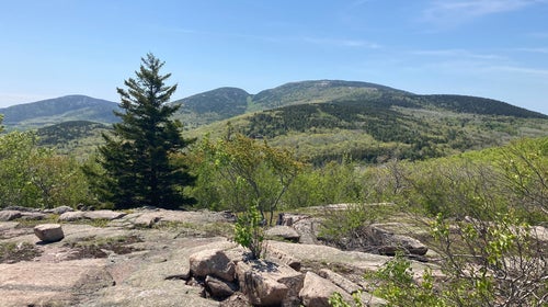
On a cloudless spring day in mid-May, I pulled into an overlook of no particular significance off the loop road that runs through Maine’s Acadia National Park. An informational placard provided tourists with a boilerplate account of a 1947 wildfire , but the site’s chief distinction was the pleasant, if unexceptional, view of Dorr and Cadillac, two of Acadia’s tallest mountains. As I maneuvered into a parking space, another motorist had his camera aimed at the peaks and was furiously snapping pictures. Beside me in the passenger seat was Matt Marchon, the 37-year-old author of a self-published two-volume work called . And fittingly, we had come to the overlook that day not to marvel at the view or learn about midcentury wildfires, but to hike an abandoned trail to a forgotten place.

We waited for a park ranger to vacate the turnout, then crossed the road and scrambled over a granite ledge, where we found an unmarked but well-trodden footpath that wound up the hillside. As we began to stroll out of sight, the tourist in the turnout gazed up at us, looking confused, a hint of suspicion in his eye, as though we knew something he didn’t—which, in truth, we did.

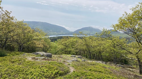
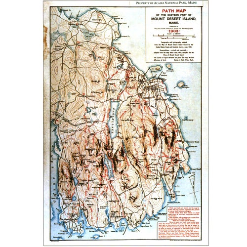
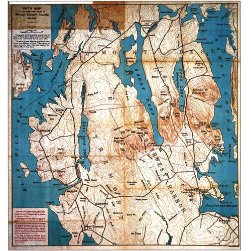
The trail, Marchon told me, led to a modest 640-foot prominence called Great Hill. When he was a kid, his parents used to pull over here frequently, and he always had a hunch that something interesting lay above that shelf of granite. “It turns out I was right,” he said proudly. As an adult, Marchon read a blog post about an old unmaintained trail leading to Great Hill and realized that it began above that very same rock shelf. But while the site is clearly labeled on most contemporary hiking maps of the region, no trails are shown leading to its summit. Look at , however, and Great Hill appears to be a major attraction, with no fewer than three separate trails leading up its slopes.

Abandoned trails like this—enthusiasts call them phantom trails or ghost trails—are ubiquitous in Acadia. Pay close attention on any of the park’s marked routes and you’ll notice rough paths branching off into the unmarked beyond. They’re often difficult to miss—the National Park Service tries to dissuade travel on these trails by laying piles of brush across key junctures, which has the paradoxical effect of loudly advertising their existence. Many of them date back to the late 19th century and lead to former sites of great popularity.

No one has yet published a publicly available map of the complete phantom network in Acadia. Though there are plenty of blogs with names like “Abandoned Trails of Acadia National Park”—many of which draw upon new, easy-to-use digital mapping technologies—a culture of secrecy still surrounds these trails, a willful insistence that some places are best reserved for initiated locals. One abandoned-trail expert I contacted backed out of talking to me, worried that others would suspect her of divulging trail secrets. When she reached out to several people in the community on my behalf, they all declined to speak with me. “They want to see things that other people don’t get to see,” Marchon told me.

I had spent much of the pandemic year living on the literal fringes of Acadia and first heard about the abandoned trails from a park volunteer. A cursory Google search yielded surprisingly detailed results about them, and I was eager to start venturing off the park map. I’m sure I wasn’t alone. While the pandemic was keeping attendance figures relatively low, the crowds that mob a handful of Acadia highlights each summer had been . It felt inevitable that increasing numbers of frustrated or adventurous park visitors would begin spilling over into the park’s trove of off-the-record bowers, cliffsides, and caves.

The search for abandoned trails is not unique to Acadia. Similar online communities exist to swap information in , , and national parks. But Acadia is distinct because its location—Mount Desert Island—puts it in close proximity to thousands of private homes. I had only to walk about 100 yards from my front door in Seal Harbor to access the trail network. It was easy to see how someone might begin to think of the park as less of a national inheritance than an extension of their own backyard, certain corners of which ought to remain forever sacrosanct.

At the end of our short climb, Matt and I were greeted by a typical Acadia summit—a wide stretch of granite partially carpeted with reindeer moss or blueberry thickets and studded with stunted gray birches and pitch pines. The view was nice. And although I couldn’t help but note that it was more or less indistinguishable from what we’d observed from the pull-off, it was hard to not feel a sense of something like self-satisfaction, the pleasure of having been inducted into some kind of recondite association. I thought back to the bewildered man at the overlook and was almost ashamed to admit to myself that I felt a bit sorry for him.

Image
A historic map of Mount Desert Island paths from 1930 (Photo: Courtesy HathiTrust)
Image
A historic map of Mount Desert Island paths from 1921 (Photo: Courtesy HathiTrust)

Mount Desert Island is a landmass whose appearance on maps is frequently likened to a pair of human lungs. It was originally christened Île des Monts Déserts by the French explorer Samuel de Champlain, who happened upon the island in 1604 while on a failed journey to the mythical city of Norumbega and was impressed with its collection of bald pink-granite peaks. Today, some three-quarters of Mount Desert Island—a mere 65 square miles—comprises Acadia, which attracts around 3.5 million visits a year. The park’s main attractions are its highest point, , from which visitors can see the nation’s earliest sunrise; Thunder Hole, a notch in the rocky coastline that produces an exceptionally loud sound when struck by waves at high tide; and Sand Beach, which is pretty much what it sounds like. The most popular activity in the park, per an Acadia spokeswoman, is “recreational driving.”

Though many park visitors are reluctant to leave the comfort of their vehicles, Acadia boasts one of the most elaborate networks of hiking trails anywhere in the country. Iron rungs snake up sheer cliff faces, wooden ladders plunge into deep crevasses, and ingenious arrangements of granite boulders guide hikers through glacier-carved gorges.

Certain elements of the island’s trail system, however, long predate these comparatively modern innovations. The Wabenaki people—who called the island Pemetic, meaning “range of mountains”—created the earliest trails, canoe portage paths that allowed for relatively easy transit between inland bodies of water. Over the course of the 1700s, European settlers built roads on the island, some of which would later be incorporated into the trail system. But the construction of what we’d now recognize as hiking trails only began in the late 1800s. Inspired by the burgeoning Romantic fascination with wild nature, artists and crowded the island in warmer months, forging paths to mountain summits from which they might blissfully bask in the beautiful and sublime. The first signs of modern trails began to appear: colored blazes to mark routes and cairns to indicate summits.

A culture of secrecy still surrounds these trails, a willful insistence that some places are best reserved for initiated locals.

Around the same time, the first trail maps materialized, growing more and more elaborate with each subsequent edition. As wealthy families—euphemistically called “cottagers”—began to fear overdevelopment, residents formed “village improvement societies” to preserve wilderness areas and build new paths. The societies’ trail construction was conducted under the supervision of eccentric elites such as Rudolph Brunnow, a Princeton professor of philology who designed, among other routes, the infamous, near vertical Precipice Trail.

Among the park’s other legendary trail architects was , a Harvard-educated lawyer who invented the eponymous Bates cairn—a style of trail marker unique to Acadia—and designed 25 miles of Acadia’s most iconic trails before stumbling to his death beneath a moving train at age 52. As men like Brunnow and Bates expanded the system, it grew fashionable for the island’s grandees to endow trails in their name after death, spurring even more construction. By the time the then-comprehensive was published in 1915, more than 200 miles of trails had been blazed and mapped.

The following year, President Woodrow Wilson established Sieur de Monts National Monument, the entity that would, in short order, become Acadia National Park. While many existing trails fell outside park boundaries, the park’s trail complex continued to proliferate, particularly during the Great Depression, when the aid of New Deal programs like the Civilian Conservation Corps and the Civil Works Administration helped created routes like the Perpendicular Trail, a monumental stone staircase that meanders up a talus slope to the summit of Mansell Mountain.

Then came World War II. With no one to maintain the trails, the system fell into disuse and the century-long pathmaking boom came to an abrupt end. In 1947, when the wildfire destroyed some 10,000 acres of the park, the trails coursing through those regions—including those leading to Great Hill—were largely abandoned. Over the next decade, amid declining trail traffic and budget constraints, the National Park Service ceased maintenance on even more trails. While some organizations produced trail maps in defiance of the park’s closures—the Appalachian Mountain Club, for instance, refused for years to eliminate certain abandoned trails from their maps—the system was incontestably in decline. Today, the trail network has stabilized at about 150 miles of trail. Impressive for a park of its size but still significantly less than it was at its peak.

Image
A historic map of Mount Desert Island paths from 1903 (Photo: Courtesy HathiTrust)
Image
A historic map of Mount Desert Island paths from 1926 (Photo: Courtesy HathiTrust)

“Urban people hike here.” This was how Christie Anastasia, an Acadia spokesperson, explained the park’s character to me. What she meant is that Acadia tends to attract visitors who prefer a gentler national park experience or aren’t particularly accustomed to the outdoors in general. Most parts of the trail network are no more than a few miles from a trailhead, for instance, and signs of human civilization are obvious from any of the park’s mountaintops. In summer, cruise ships crowd the docks of nearby Bar Harbor, spilling out people who migrate to the park on daylong “excursions.” On any given summer day, Christie told me, there are some 5,000 people on Acadia’s trails.

Given this strain on the park’s resources, it’s inconceivable for Acadia to embark on an extensive program of reopening old paths. According to Gary Stellpflug, the park’s trails foreman, restoring even a small stretch of abandoned trail takes several seasons of work by a 20-person crew, along with hundreds of volunteer hours. A called for a mere 8.42 miles of abandoned trail to be rehabilitated; the park is still in the process of implementing it.

In considering which trails are to be reclaimed and which should be left off park maps, the Park Service considers four main factors: cultural importance (Acadia’s system is currently protection under the National Register of Historic Places); ecological impact (“Trails are just a damaged part of the landscape,” Marchon told me); safety; and what the Park Service calls “visitor experience.”

A useful example: one phantom trail leads to a vaulted sea cave, briefly accessible at low tide. The cave, , the Cave of the Sea, or Devil’s Den, was once, like Great Hill, a principal tourist attraction. was rhapsodic about its natural wonders: “The most exquisite sea-anemones, orchids of richest colors, zoophytes, star-fish, and most delicate weeds and mosses—all of them presenting the prettiest picture imaginable.” A lithograph accompanying the article features a corseted and bonneted Victorian gentlewoman gazing intently into a tide pool on the cave’s floor.

Over the years, overuse gradually eroded the cave’s fragile ecosystem. The eponymous anemones were trampled into near-extinction. Around 1970, the park scrubbed the route and cave from its public materials. Having failed the ecology test, the trail leading to its entrance was effaced, the signage and metal railings dismantled. (It would fail the safety test some years later when a teenager drowned there in 1993.) When I made my way down to the cave last spring, there wasn’t another soul around. I asked Anastasia whether a typical park ranger would have guided me in the right direction if I’d asked about the location of Anemone Cave. The answer was a clear no. While visitors have a right to explore off the official trail network, she said, they shouldn’t expect park staff to encourage it.

Stellpflug emphasized that many abandoned trails run through areas of the park that they would prefer remain untouched. “Some of these sites are really getting hammered,” he said. I asked him whether the park would ever consider formally closing off a region of Acadia for this reason—a step it has never taken to date. “I think it’s in the park’s arsenal of tools,” he said. “There can be too much of a good thing.”

Image
The modern National Park Service map of Acadia National Park (Photo: National Park Service)

The morning after I met with Matt Marchon, I drove to another unmarked trailhead to meet Tom St. Germain, the undisputed preeminent chronicler of Mount Desert Island’s trails, phantom or otherwise. His deeply researched 1993 book, , has fetched prices upward of $500 on used-book websites, a fact that we found mutually astonishing. A restaurateur by trade, the 54-year-old St. Germain wore a close-cropped military-style haircut and rectangular glasses. He looked distressingly fit. We were scheduled to hike a mere five miles of abandoned trail that day, but the following morning, he told me, he planned on tackling a 31-mile run through the park, entailing 11,550 feet of elevation gain and traversing 25 different mountain peaks.

By the time I met him, St. Germain had become a minor celebrity to me. During my time on Mount Desert Island, his hiking guide (I couldn’t afford Trails of History) had served as a kind of sacred text, leading me along many of my own favorite marked and maintained paths. Trails of History, however, broke genuinely new ground. Building on the efforts of “trail bandits”—the 1980s epithet for those who sought to find and restore old trails—Trails of History was the first historical account of how Mount Desert Island’s path network was constructed. St. Germain and his coauthor, Jay Saunders, spent years in archives up and down the East Coast, poring over old maps and guides. St. Germain read every Bar Harbor newspaper published over a seven-decade period. By the time the pair finished writing, they had spent some $28,000 over the course of their research. Sales from the first edition amounted to $27,000.

Given his intimate relationship with the island—St. Germain is on the Bar Harbor Planning Board, as well as the board of the Bar Harbor Historical Society—I expected him to be particularly sensitive to local concerns. But for St. Germain, the question of secrecy had long been moot. “There’s no such thing as a secret place anymore. There simply isn’t. The evolution of trail maps has taken a completely different turn than I ever anticipated 20 or 30 years ago.”

The widespread use of open-source GIS software and other map-building tools, he argued, had created a cartographic environment in which “maps create themselves.” He cited the example of Strava, which, in addition to ranking users according to performance, tracks their GPS data as they walk, run, or cycle. If he were to record himself hiking an unmarked route in Acadia, that data would then be uploaded to Strava’s database, in effect sketching a map as he travels. (As it happens, he holds trail-running records for hundreds of different routes on Mount Desert Island.)

“There’s no such thing as a secret place anymore. There simply isn’t.”

St. Germain took me on an old, unmarked route leading up the eastern face of Cadillac Mountain’s south ridge, a granite trail riddled with eroded, baseball-sized depressions, and told me about an aborted book project. It was to be called Hidden in Plain Sight and would have finally laid out in print the full extent of Mount Desert Island’s abandoned paths. The problem was, according to St. Germain, that the project would have already been rendered superfluous by the time he completed it, the trails no longer hidden.

“People who are reading about something on some social media and say, ‘I have to do this lost trail in Acadia,’ they go out and find it, because it’s not that hard,” he said. “There are a hundred different descriptions on how to find starting points and ending points, and then, once you get out there, the more it gets used, the easier it gets to follow someone else’s footprints.” Once the secret is out, in other words, there’s a kind of snowball effect—use begets use on an app like Strava, of course, but also in the very dirt of the trail itself.

As he spoke, I began considering how much of our hike I wanted to divulge when I sat down to write this article. How would I eventually go about describing this trail? What clues would I give—even unintentionally—about its course? Would I provide the trail’s name? What did I owe to the local community, if anything? What did I owe to the park and its history? What did I owe to the trail itself?

I was still mulling these questions when we returned to the trailhead. There was now a third car parked beside our vehicles, on an otherwise nondescript stretch of undeveloped road. Its license plate was labeled “New Hampshire.”