
At 5:30 on Monday morning, I joined a small huddle of journalists on the South Rim of the Grand Canyon to get a first look at the completed Google Trekker on its inaugural trip into the wilds.
The 75-megapixel cameras have 15 lenses.
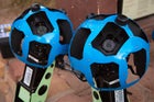 The 75-megapixel cameras have 15 lenses to create a seamless 360-degree panorama.
The Trekker is 4 feet long and weighs about 40 lbs.
 The Trekker is four feet long and weighs about 40lbs.
The hard drive and batteries are protected by a waterproof door.
 The hard drive and batteries are protected by a waterproof door.
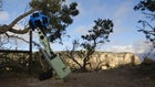
Trekkers heading down for an overnight in the Grand Canyon.
 Trekkers heading down for an overnight in the Grand Canyon.
Coming through the mist with headlamps and a bright blue and green contraption peering over each of their heads, the Google engineers look a little extraterrestrial. “No one’s going to sneak up on you with a ,” said Steve Silverman, the project’s operations program manager. “We want people to see it and experience the same sort of excitement they do with the car.”
But if anything, sighting a Street View hiker is more thrilling than getting scanned by the car. The 75-megapixel camera is mounted in an aluminum baffle, resembling a massive soccer ball, and with the rig on a guy’s back, you can get close enough to look into one of the 15 lenses that capture a brisk 2.5 frames per second. The lenses are bespoke, like almost everything on the trekker, and specifically designed to reduce flare from the sun. The whole system is controlled by an Android phone, which monitors the navigational system and allows the user to look at photos from the camera as they’re being taken.
In development, Luc Vincent, the project’s engineering director, has been taking the Trekker out for some cross-country skiing runs around , so he knows the effect it can produce. “People looked at us like we were from outer space,” he said. “In Squaw, a kid came up to me and asked why I didn’t just use a GoPro. I said, this is a bit different.”
Vincent has been long anticipating this trip, where he and his team will map the iconic and spend the night camping at Phantom Ranch. In fact, the Trekker team, made up of engineers and software designers, all looked thrilled to be on trail. They say they had to fight for their spot on this project, beating back the surprisingly large number of outdoor enthusiasts at Google.
The was a spectacular backdrop for the Trekker’s dry run, but the location also posed certain challenges that were integral in shaping the design. A hiking rig would have to be wearable, lightweight, robust, with good battery life, built to compensate for the unsteadiness of a hiker, and able to operate in a remote area where GPS can’t reach. You need a system that works even when satellites won’t—for instance, in the shadow of a canyon’s walls.
“It was really important for us to have the same sort of seamless resolution for the Trekker as we have for the car, and especially in this environment, you don’t want to compromise on that,” said product manager . “We have a whole variety of sensors, including gyros, magnetometers, barometers, and accelerometers to fill in the gaps of the GPS.”
The setup also had to be weatherproof. The removable hard drive and eight-hour rechargable batteries are protected by a door with a waterproof O-ring seal. The Trekker can be submerged for 10 minutes under one meter of water and withstand temperatures ranging from -15 to 115 degrees Fahrenheit.
Much of the design process involved stripping down the housing until it was as light as possible, bringing the pack from 65 pounds to a more manageable 40 pounds. Trying it on, it was surprisingly comfortable, even with the heavy camera high overhead. The team said they’d worked hard to get the center of gravity just right.
“What we’re trying to do is make this accessible, and we definitely want to scale this down so that it’s smaller and lighter and can go more places,” Silverman said.
The team has created a user interface that’s so straightforward, anyone can operate it. And while Google won’t offer any hints as to what far corner of the earth they want to take it next, they did say that they deliberately made the batteries adhere to international shipping standards, and the design friendly enough that a volunteer could strap on the pack and go. Everest maybe? “That would be a good challenge,” Silverman said, smiling. (So if you want to take the Trekker on your next trip to the Himalayas, it’s not out of the question.)
Google has created the Trekker as a tool whose full utility will be up to the user. The team says they’d like to form as many partnerships as possible all over the globe. This year, Google teamed up with to design a modified panoramic rig that could be used underwater . There’s also potential for the maps to assist in search and rescue, identifying areas where a lost party might have made a wrong turn or run into trouble.
“We’ve found in urban environments that firemen and policemen frequently use it. And the same thing could happen here,” Vincent said. “If something happens on the trail, you could better see what the conditions might be there, whether to send a helicopter in, for example. It’s more information to help you make decisions.”
Google Maps plans to release sets of Street View trail maps by region beginning in a few months, once they’ve covered enough ground to make up a network.
Maureen Oltrogge, head of public affairs for Grand Canyon National Park, sees search and rescue efforts daily in the high season, when the heat in the canyon can soar in excess of 120 degrees. She says she welcomes all potential tools in helping with that effort, and in educating the public. But she also cautioned that the Trekker should be just one of a number of tools visitors use: “It could give you a false sense of security. This can be an unforgiving environment.”
She’s hoping that visitors won’t rely on being able to use Street View to help them navigate on trail. Cell phone reception drops off dramatically as you dip below the rim. The Trekker is also only dispatched on good weather days, to prevent precipitation from spoiling the picture. As a result, Street View is likely to show more bluebird days and won’t necessarily be representative of actual conditions on the trail.
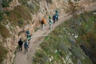
We watched two Trekkers, with two support crew carrying their food and camping gear, head into the canyon toward Phantom Ranch, where they spent the night and hiked out on the South Kaibab Trail the following day, successfully capturing about 18 miles of trail.
As they disappeared into the canyon, several other Trekkers were deployed to cover the upper part of the trail and make sure they had enough data for some very clean maps. As the hiker traffic increased, a group of four passed by wearing GoPros strapped to their foreheads. Despite last week’s release of the Hero 3, it was hard not to wonder aloud if we were looking at a fading technology.
“For just trying to document a trail, it’s going to be hard to beat this, because we have a very high level of geolocation,” Silverman said. “So we have all the tools you can find to position our pixels on a map, and that’s really why I love Google Maps. They just get better and better. We really care a lot.”