

IT'S MERELY A COINCIDENCE that our path has intersected at all with the unmemorable little overpass we're currently looking at, just outside the town of Crapaud, along the southern coast of Canada's Prince Edward Island. If the bridge weren't here, Roo and I would simply wade across the stinky tidal estuary it spans—and keep going on our merry linear way. But it's right on the line, so we must deal.
walking
 “We will do everything—eat, sleep, and eliminate—along the line.”
��
The approach is easy, if a bit muddy. All we have to do is scramble up the embankment and walk across the bridge diagonally. Getting down will be trickier. It's about a ten-foot drop to the bank below, at which point we'll have to wade through the middle of the estuary. Although we've already used our ice axes to notch steps up a steep and chalky cliff on the coast, this will be our first really challenging obstacle. Roo is excited.
“An impromptu rappel!” he exclaims. “Not a problem.”
I knew Roo would be a kindred spirit on this adventure. Roo is short for Andrew. He's my oldest friend, gonzo, and a total badass. He spent several summers as a Hotshot, parachuting into forest fires. He can quote Tennyson at length. He can exhale and, while holding his breath, do 25 push-ups.
The 200-foot rope in his pack, however, seems a bit excessive for the task. Instead he opts to wind a couple lengths of slippery old parachute cord and frayed webbing around the metal guardrail. Glaucomatous tourists in midsize rental cars veer frighteningly close on the shoulderless road as Roo, clad in only shoes and shorts, lowers himself off the bridge, hand over hand.
Once safely on the bank below, his head now just a few feet beneath where I'm standing, he cups hands to mouth and yells, approximately 40 times louder than necessary, “Belay off!” “Off belay!” I shout back.
Roo then stuffs his backpack into a mostly dry drybag and balances the load atop the pink inflatable sunfish that, in an inspired moment, we picked up last night at a big-box store. Holding his ice ax in one hand, and pushing the pool toy with the other, he wades into the murky water. The sludge rises to his thighs. His belly button. His armpits …
Midstream, he all but disappears. Only his flailing ice ax and shock of frizzy Michael Bolton hair are visible above the scummy surface.
“Aaaargh!” he bellows, erupting triumphantly from the depths, strands of seaweed hanging off his chest hair.
Now it's my turn. Wearing nothing but my hiking shoes, aviator sunglasses, and tighty whities (I forgot shorts), I follow. Creosote from the bridge pilings covers my forearms as I slide down the cord. The soft tissue of my hands begins to tear a little and then—plunk—I land ass-first in the mud.
Once across the tiny inlet, we check our progress: 2:17 p.m. We started at precisely 1:42, which means we've traveled roughly 100 yards in 35 minutes. Not bad, but we're definitely going to have to pick up the pace.
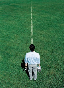
THERE ARE VARIOUS rationales for keeping it straight. Conservationists like megatransecter Michael Fay have crossed equatorial Africa, or walked from the southernmost redwood tree in the U.S. to the northernmost to help gauge the ecological health of the planet. Landscape artists like Richard Long, who in 1967 spent weeks trampling a perfectly straight line in the grass in the English countryside—which he then famously photographed in black and white—do so for the sake of aesthetics. Others, like fisherman and author James Prosek, are propelled by more ethereal reasons. A few years ago, Prosek decided to walk east out of his Connecticut home and … just keep going along the 41st parallel. He eventually circumnavigated the globe, fly-fishing with people he met along the way. When he got home, he wrote a book about the experience.
Our motivation is simpler: Roo and I just want to see how straight we can go. Walking, from point A to point B. With a fancy GPS showing us the way and a nifty SPOT “satellite GPS messenger” device tracking every millimeter of our progress, we will go through, up, or over anything in our path. We will do everything—eat, sleep, and eliminate—along the line. We both agreed: zero deviation is the goal, and the route had to be chosen randomly.
To get started, we grabbed a U.S. atlas, flipped blindly to a state, each dropped an index finger, and pledged to trek from Carson City, Nevada, to Highway 375, a remote road in the eastern part of the state. But then we saw that our route crossed an Air Force bombing range.
Our moms were not happy.
Better destinations didn't immediately present themselves. We knew that many Americans, especially southerners, take trespassing seriously, so tromping through densely populated areas was basically out. And we had no burning desire to go back to the Northwest, where Roo and I grew up. In July 2008, we'd traversed the Olympic Peninsula together, and despite the fact that we used trails and tried to pick the easiest route, it was an extremely arduous trip.
“Bisecting an island could be fun,” Roo offered. That's when we discovered PEI. Like most Americans, we didn't even know that the crescent-shaped island above Nova Scotia constituted its own province. But a quick tour via Google Earth confirmed that it is, and that it's indeed as pastoral, sparsely populated, and flattish as advertised.
Trip preparation would be minimal: as we do for almost every adventure we take together, we packed like we were going on a mountaineering trip that would end at a bachelor party. Which is why, in addition to the pool toy and ice axes, we also had crampons, a dozen or so tins of Spam, and one stick of Old Spice jammed in our backpacks.
We decided to start the beeline in early September, in the charming southern hamlet of Victoria. Following 63°W, heading north-northeast, we'd end up near the northern coastal town of Cavendish, at the island's most famous attraction, a theme-park-like re-creation of the home of Anne of Green Gables. (The novel's author, Lucy Maud Montgomery, grew up on the island and based the story on her childhood.) It looked to be about 20 miles, a distance we figured we could cover in three days.
The only catch was the weather. If the Super Doppler in our hotel room was right, a hurricane named Earl was on track to wallop the island in the next 24 to 36 hours. But, truthfully, we welcomed the drama. I'm not sure what we were expecting, but Rambo definitely wouldn't have been intimidated by the island's gingerbread houses and jam sellers and tidy farms and carriage drivers.
“MIND IF WE CUT through your yard?” Roo asks a thin man in front of a yellow house at the edge of Victoria.
“Sure. What for?” the man replies, shutting off his mower.
“We're walking a straight line to Anne of Green Gables' place,” Roo says, vaguely indicating north with the GPS in his hand.
Like every nonchalant resident we'll meet in Canada, the man never questions the genius behind our adventure. He's just happy to help—and point us on our way.
“Please stick to the troughs to protect the potatoes,” he advises, gesturing toward the farm field across from his house. We gingerly step over his garden bed and keep going. A few potato fields later, we come upon the irksome bridge, but otherwise we make good time. Having programmed our endpoint into the GPS, all we have to do is follow the directional arrow on the screen.
We hew to the line, past radio towers and the occasional abandoned barn, through tame shires and small, infrequent woodlots, across innumerable potato fields, with gully-bottom springs providing plenty of drinking water. We're fully prepared to ask people permission to clamber over their toolsheds or walk through their homes, but the only other truly awkward moment is watching Roo crawl underneath a for sale sign that, quite literally, straddles the line.
Roo always leads, slipping forward like a stealthy tracker, letting branches and leaves hit him and slide off. I stomp and plow inelegantly after him. When we hit a wash of pea plants, I'm like a kid jumping in puddles. With each big, disruptive stride, a riot of white flowers shakes and erupts with a cloud of white butterflies.
Our line meets up with a few roads, including the Trans-Canada Highway, but we're always happy to veer back into the island's underbrush. There's a jailbreak-like freedom in our pursuit. All we hunger for is this vector of purpose.
“I think straight-lining could become a new sport,” I say. “Like geocaching.” “Or confluence hunting,” suggests Roo.
At 8:45 that night, having averaged a respectable one mile per hour for seven miles, we make camp at the scenic crest of a ranch—a nice spot, even if it's polka-dotted by cow patties. Best we can tell, we've hardly swerved.
At Roo's decree, we decided to leave our sleeping bags behind. “The Line will provide,” he had confidently proclaimed. But all that's available at our current bearing is enough dry grass for two scratchy pillows. As we lie uncovered in our floorless tent, cruel mosquitoes pester my exposed cheeks. I wrap my jacket around my head and, like a true backcountry genius, breathe through the mesh lining of an unzipped pocket.
“Check it out!” I command Roo, my pride only slightly muffled by the folds of fabric across my face.
WE WAKE UP ON THE LINE in good spirits. Because there's a pine tree on it, and because Roo is Roo, he decides to amuse himself by lashing crampons to his wrists, climbing like a bear, and then getting stuck ten feet up.
“I'd really like to put some miles in before Earl,” he yells. We can feel it coming; we strike camp under a low cloud ceiling.
The mission starts going sideways, literally, when we wriggle under the first of what will prove to be dozens and dozens of rusty remnants of barbed-wire fencing, followed by the first beastly swath of new-growth forest. Roo slinks through, like a deranged ninja. I grab and swat at the thorny sprigs, my frustration compounded by the fact that, right beside us, not a stone's throw away, is a perfectly unobstructed wheat field.
Following the line becomes increasingly difficult. In the densest patches of woods, even Roo needs his hands for balance and can't constantly check the GPS. Walking on seemingly endless sidehills, we suffer what Roo calls “landscape drift”—that is, the tendency to edge downhill. To make matters worse, the arrow has begun to swing erratically, perhaps because of the thick cloud cover.
At noon, we finally cross the halfway mark at Highway 225, east of the unincorporated township of Stanchel. A tenth of a mile later, Earl happens. Instantly, it's like we're inside a washing machine. A thrumming windmill nearly spins off its bearings. In the barnyard beside it, hundreds of cows moo and bray in a dolorous panic. “Rain is hitting me inside my ear,” I yell to Roo, who hands me a black plastic trash bag—a.k.a. an “Oregon prom dress.”
We thrash through a cornfield and—sorry, Mr. Farmer—I can't help but break a few stalks. I place my arms in a V and blunder forward. With the 50-mile-an-hour winds shaking the tall, slimy heads of corn, vertigo takes over, leaving us to blindly stumble through. Roo stares at the GPS while suffering the indignity of being slapped in the face by a vegetable.
An hour later, queasy and shivering, we lunch on chips (crushed to dust) and Nutella (rain puddling in the jar). The fact that we're still apparently on track means little as I stare at another ankle-busting clear-cut.
“We must obey the line,” says Roo, sensing my apprehension. “There's no negotiating with it. No compromising. Only submission.”
We slog on. Clear-cut, bramble thicket, drippy hollow. A potato-field respite. Mossy logjams, witch wood, swampy creek aflood. Arpeggios of grief. Four hours later, the rain subsides to a drizzle. Then stops.
My forearms and shins are scraped bloody. Some mysterious native plant has left my arms with a red and bumpy rash like poison ivy. The soles of my day hikers have delaminated, flapping like duck bills with each step. Roo's pants have torn, becoming capris, and his shock of hair has, like Velcro, grabbed twigs and leaves and unsuspecting insects. The line has become oppressive—and not just because of its challenges.
Trails, no matter how circuitous or zig-zagging, follow a certain logic that's always interesting on some level. Tracing the lay of the land, paralleling streams or contouring around ridges, they offer a human interpretation of the ecosystem.
But our line exists in complete disharmony with the topography. It simply knifes through ever-more-enervating obstacles. “This trip is like life,” Roo moans. “It makes no sense. It's just one thing after another. With lots of potatoes.”
IT DOESN'T LOOK LIKE MUCH, this tiny grove of deformed little spruce trees growing three feet apart. Yet for us, completely fed up with the challenge but stubbornly refusing to swerve, it is utterly demoralizing.
As families in their Sunday best exit a lone country church down the road, we drop to our knees like penitents and tunnel into the undergrowth, dragging our packs behind us. Roo is almost pinned facedown, slithering in pine-needle mulch. I'm nearly suspended in the air by a thousand little branches that work like magic fingers. When the path opens up, I go back to bashing. Moments later, a branch pokes Roo just below the eye. His orbital socket instantly turns red and puffy.
He doesn't want to spend a second soggy night on the line. I won't say that he cracks—Roo never cracks—but he comes as close as I've seen. We push on into the night.
At 9 p.m., we are four miles out, flying by instruments. With one extended arm, Roo holds the GPS; with the other, he cocks the flashlight at his ear like a SWAT officer gone savage. We cut across drainages, get hobbled, make lineman charges into walls of brambles.
When we erupt onto a fairway of the Green Gables Golf Club, we know we must be getting close. An hour and a half later, we emerge from the woods not 250 feet below the re-created Green Gables. It's 2 a.m. A faux barn and faux granary have never been such a welcome sight. A few days later, back home, I plug our SPOT into my computer. In moments, our entire route and stats pop up on Google Maps. We bushwhacked for 21.3 hours over two days. Top speed: 3.3 miles per hour. Average speed: 0.9 miles per hour. Slowest: 0.3 per.
I zoom in on our line and … damned if it's not as straight as Jason Bateman. Our two biggest detours, maybe 30 feet, appear to have occurred (first) when someone advised us not to cross his neighbor's yard and (second) when our GPS went on the fritz during the storm. Later that day, I forward all our data to my buddy Ariel, a math whiz who has generously offered to crunch our numbers. Using some fancy algorithms, he estimates that, on average, we were 0.0355 miles astray from a perfectly straight line.
Sounds impressive, until I realize that that's 187 feet. Sensing my disappointment, Ariel explains that while the number is accurate overall, it's not a good indicator of how committed we were, footstep by footstep, to going straight. Because we didn't keep stopping to recalibrate, our path was essentially a continuous sequence of slightly slanted vectors. “Like homing missiles,” says Roo. “Not weenie-ass orienteers.” Which makes me feel slightly better—but doesn't make the lingering rash on my arm go away.