

MUD ON THE BANKS of the Missouri River will suck you down to midcalf, pull the boots or sandals off your feet, cling tenaciously to your skin, clothes, canoe, ice chest, and every last thing you own, and then accompany you home and distribute itself around your living quarters and deposit a ring around your tub that seems to wash off and then magically reappears for about a week or seven. The enduring and insistent mire is locally called “gumbo” and is sometimes described as “greasy.” After a heavy rain, the mud extends out miles from the banks of the river. Most of the roads to and from the Wild and Scenic section of the Upper Missouri—which, to confuse matters, is located in Montana—are gravel or dirt, and it’s simple to drop your car axle-deep into the gumbo mud, a situation that can be life-threatening along the Missouri at its most Wild and Scenic, an area that is not within walking distance of anywhere. I know; it’s happened to me.
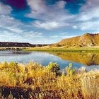 Lewis and Clark wuz here: the soft sand cliffs and pyramids along the Missouri Breaks
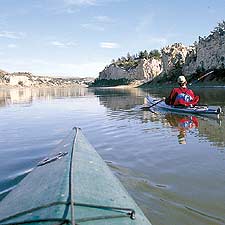
 David Fox leads the way in the not-so-Wild and Scenic Missouri
When I first moved to Montana, I promised myself that I’d float the Missouri right away. I didn’t make it that year, or the year after. Suddenly, or so it seemed, a couple of decades had elapsed and their weight began to smother my ambition and erode my conviction that floating the Missouri was something I really needed to do. But whenever I next checked the Life List, there it was, “Missouri River Float,” undone and staring me in the face like an accusation. Smothered ambitions and eroded convictions had combined to form a river dream; a greasy dream, but a dream nonetheless. This year, at last, I decided I had to float the Missouri and I had to float it now.
And so I was on my way to Fort Benton, Montana, the put-in point for the 149-mile-long Wild and Scenic section of what, in any fair and decent world, would be considered the longest river on the planet. The Missouri rises at Three Forks, Montana, at the confluence of the Jefferson, Madison, and Gallatin Rivers, flows vaguely north, and then turns east through Montana to North Dakota before dropping south through South Dakota, Nebraska, and Missouri, finally joining the Mississippi at St. Louis. That’s 2,546 miles: longer than the upper and lower Mississippi put together.
If the Mississippi is to be considered a continuation of the Missouri—as I’m arguing it should be—the river is 4,220 miles long: longer than the Nile (4,160 miles), the Amazon (4,000), and the Yangtze (3,434). It’s a great big huge world-beater of a river, a ribbon of history and geology and wildlife. Along the free-flowing Wild and Scenic stretchof the Missouri, mule deer and bighorn sheep frolic all over the adjacent geology, mourning doves mourn unseen in the occasional cottonwood, and rattlesnakes hiss from the banks. There are 13 Lewis and Clark campsites, some of them set amid cliffs that look like toadstools or ancient Greek temples or castles in Spain or defunct comedians; there are dinosaurs, buried in the mud; there is a violent and often grimly amusing history; and there is, of course, the matter of my own greasy river dreams.
FORT BENTON, MONTANA, was one of the truly tough towns of the old West. At the turn of the last century, it was, according to one newspaper, “a scalp market, the home of cutthroats and horse thieves.” Armed robberies, gunfights, and lynchings were common, almost daily, occurrences. The U.S. Army saw the town as “a whiskey trading post for hostile Indians.” And indeed, there is a recipe for “Indian whiskey” at the local museum: “To muddy Missouri Water add 1 quart of alcohol, 1 pound of rank black chewing tobacco, 1 handful of red peppers, 1 bottle Jamaica ginger, and 1 quart black molasses. Mix well and boil until strength is drawn from the tobacco and peppers.” Firewater indeed.
In 1868, irate citizens of Fort Benton lynched their own town marshal in an effort to make the streets safe for extreme drunkenness. It seems someone had been stealing from passed-out
inebriates distributed about in the muddy streets of an evening. Townsfolk complained to the marshal, William Hinson, who said (regrettably, he may have thought later), “What our town needs is half a dozen hangings.” A vigilante sting operation sent out a decoy drunk one night, and it was discovered that Hinson himself was the thief. The next day, the citizens told Marshal Hinson they knew who’d been stealing them blind, told him they were going to hang the fellow in half an hour, and asked him to bring a rope. And thus Hinson’s last official act was supplying the noose for his own execution. The hanging site is right next to the present-day Episcopal church, and most citizens, I imagine, would be happy to point it out to you. I don’t know. I didn’t get to stay in Fort Benton very long because I was late. So was everyone else.
Bobbie Gilmore, a kayak guide, had come from Whitefish, Montana, hauling a trailer full of sea kayaks. My old pal, photographer Joel Rogers, came from Seattle with two of his friends, David Fox and Scott Wellsandt. Linnea Larson and I were driving in from the other direction, and we all got to Fort Benton at about the same time, which was several hours later than we’d planned. It was a graceful little town of shady neighborhoods and old brick buildings fronting the river. The Grand Union Hotel, once the finest accommodation between Minneapolis and Seattle, had been nicely refurbished. Wise travelers might have checked into the hotel and gotten a leisurely start in the morning. We packed up the kayaks in a frenzy of sweat and began having fun right away.
We paddled 45 minutes, until it was almost dark, set up our tents, prepared dinner—I don’t recall what, it may have been Joel’s quesadillas—and sat around the fire, catching our breath. There were no artificial lights anywhere and the stars were bright enough to cast shadows. It was a time for thoughtful comments on the journey ahead.
“You know,” I said, settling back with a drink, “it takes a real moron to forget his sleeping bag.”
“You forgot your sleeping bag?” Joel inquired.
“Isn’t that what I just said?”
THE NIGHT WAS MILD—the others were fools to carry bulky sleeping bags—and then it was dawn and we were up and paddling. There were a few pelicans downriver; they rose up as we approached and we floated under them as they soared overhead. I love the idea of pelicans 800 miles away from any ocean and, quoting from Linnea’s bird book, told everyone that the birds had a wingspan of nine feet.
“I don’t think that one does,” David said.
“Probably a juvenile,” I said.
“Those two don’t,” David continued, “or that one either.” When David was last in Montana, he testified in a Billings courtroom. He’d been working for NBC, covering the Freemen militia standoff outside Jordan. The Freemen had “confiscated” his video cameras, probably for being too literal about eyewitness evidence, like the wingspan of certain birds.
We passed through Black Bluff Rapids, which is marked at river mile 20 on the BLM Upper
Missouri National Wild and Scenic River map. The water was smooth as a mirror—a muddy mirror—and the rapids didn’t
actually exist.
In point of fact, most of the “rapids” marked on the map are from the steamboat days of the late 1800s. They are gravel bars, or areas that are tricky to navigate upriver in a steamboat. The Missouri trucks along at an easy average of 3.5 miles an hour and there is virtually no whitewater whatsoever. It is a lazy float,
appropriate for beginning canoeists or kayakers or rafters. I
suppose you could get in trouble on the river, but you’d have to work at it in a fairly assiduous manner.
Bobbie, apparently attempting to raise the adrenaline quotient, said, “Well, in a couple of days we’ll hit Deadman Rapids.” She let the name sink in. “Women,” she added solemnly, “can go through there.” At mile 22 we passed the mouth of the Marias River on our left, where Meriwether Lewis and William Clark spent nearly ten days on their upriver trip: June 2 through 11, 1805. They were stuck there in the throes of a navigational quandary. Their mandate from President Thomas Jefferson was to ascend the Missouri, cross the Rocky Mountains, and descend the Columbia to the Pacific. At this fork in the river, each stream seemed about the same size. Which was the Missouri? (These days, there is little doubt. The Marias, confined by the Tiber dam, 70 miles upstream, is now little more than a creek at its confluence with the Missouri.)
Most of the men in the Lewis and Clark party thought the north fork, the Marias, was the Missouri; both Lewis and Clark were skeptical. They measured the width of each stream, explored up the banks of each, and inquired locally, always a prudent move for any traveler. Bolstered by what the Indians said, they concluded, correctly, that the south fork was the Missouri and would take them into the mountains.
The river carried us past the Marias. Bobbie was giving Linnea some paddling advice. I was eavesdropping because I can use all the help I can get. “I tell my clients that a woman’s center of gravity is lower, so women are more stable in kayaks than men,” Bobbie said. “Women are probably more stable in life altogether.”
“You mean,” I asked, in all innocence, “because they got fat butts?”
“Said the moron who forgot his sleeping bag.”
THE CHARACTER OF the Missouri changes abruptly 39 miles into the float. At first it’s just as one might
expect: a big, slow-moving river meandering across
a high plain, with mountains shining in the far distance. But at the ferry-crossing town of Virgelle, the river changes direction, sweeping almost 90 degrees from northeast to southeast. The Missouri straightens out and floaters find themselves, for part of the rest of the trip, in a canyon several hundred feet deep. It is a relatively new thing, this canyon. The Missouri used to flow north, toward Hudson Bay, but glaciers grinding down from Canada during the Ice Age blocked the northward run and formed a dam that turned the river south and east. The Missouri spun about in a rage and shot through soft rock to the south, tearing up the land in a fury of frustration. The rocks were and are soft because this area of Montana was once a vast
inland sea. Dinosaurs romped along on its banks, especially to the east, near the final stretch of what is now the classic Wild and Scenic float. When the sea finally receded, 65 million years ago, it left a legacy of sedimentary rocks—clays, sands, silts, a dried-out sea bottom, essentially—and the Missouri, diverted by massive ice sheets, cut through this soft stone like a hot knife through butter.
Meanwhile, tributary streams flowing into the Missouri from either side formed their own small canyons, which cut into the main channel of the river. It is a strange, crumpled landscape, odd and alien and vaguely disturbing. The land seems not at all as it should be; it looks somehow shattered, broken, and anyone who sees it will know immediately why the area is known as the Missouri Breaks.
Ten miles into the canyon, sandstone parapets rose on the riverbanks, and the vertically striated columns stood out like eroded statues in Egyptian temples. The canyon walls—all battlements and spires like broken teeth—enclosed us as we floated farther downriver, eventually camping for the night near Eagle Creek, at the Lewis and Clark campsite of May 31, 1805. “The hills and river Clifts which we passed today exhibit a most romantic appearance,” Lewis wrote in his journal that day, almost two centuries ago. “The bluffs of the river rise to the hight of from 2 to 300 feet and in most places nearly perpendicular; they are formed of remarkable white sandstone.”
I was reading aloud from the journal now, and what we saw in the dusk directly across the river was the exact sandstone wall described by Lewis. “The water in the course of time in
decending…has trickled down the soft sand clifts and woarn it into a thousand grotesque figures…”
“Exactly,” said Scott.
Lewis, with “the help of a little immagination and an oblique view,” saw “eligant ranges of lofty freestone buildings, having their parapets well stocked with statuary.” He saw “collumns standing almost entire with their pedestals and capitals.” He saw stone “in the form of vast pyramids of connic structure bearing a serees of other pyramids on their tops.”
“What do you see?” I asked Scott.
“That one over there looks like the skinny Laurel and Hardy guy. Stan Laurel.”
We declined the opportunity to make fun of Scott’s vision. Not only was he a great big huge powerful guy, he was the best cook on the float. This evening he’d made pad thai on a camp stove, and it was delicious. “Stan Laurel,” I said, hoping Scott would cook for the rest of the trip. “Anyone could see it.”
“DID THE COPS question you about it?” I asked Bobbie late the next day.
We were standing just across the river from our campsite, on top of the cliffs, staring numbly at the remains of a formation once a familiar landmark to Indians and fur trappers and steamboat captains. What we saw was a pair of inward curving arms, each about ten feet high, stretched upward to the sky, as in supplication. The arms had once held and balanced capstones so that the formation was a graceful natural arch 11 feet high, a landmark called the Eye of the Needle.
“We talked to the BLM and the local cops. We were the last people to see it before…”
Sometime between May 25 and May 26, 1997, a vandal or vandals pried the capstones off the top of the arch and pushed them over the cliff.
“I was guiding a group,” Bobbie said. “We were the last people to see it intact. Climbed up here on Memorial Day weekend. It was rainy and slick and it poured rain all the next few days.” The steep climb winds its way up through a narrow chute, and it is necessary to move carefully, three points on rock at all times. Bobbie carries a climbing rope because a sudden rain can turn the chute into a water slide. “The next group to come through reported it down. Some folks think it may have collapsed on its own, but the cops told me they found the marks of a metal bar on the rocks that had been kicked over the cliff.”
The FBI was called in, Bobbie and her group submitted their snapshots—the last photographs ever taken of the intact formation—and then the years began to gently drift along, no arrests were ever made, and the remains of the Eye stand sentinel over the river, testament to a certain virulent variety of human disfigurement.
Late that afternoon, we climbed back into the cliffs behind our campsite. The rock walls closed in around us, forming a water-carved, keyhole-shaped passage of the sort found in caves. Several fallen boulders the size of trucks or houses blocked the way, but Bobbie led us scrambling over them, insisting that she had something to show us. And indeed, when we topped out, we immediately saw another Eye of the Needle—an arch of about the same size, wind-scoured and smooth as gritty marble. I climbed up to get slightly above this peculiar eye, and when I looked through it, there, below, stretching out for over a mile, was a maze of canyon and tortured rock, perfectly framed: an invitation to commit poetry or philosophy or any number of the higher aesthetic or contemplative crimes. I imagined there were other Eyes, in other drainages, none of them actually on the river, but all probably worth a climb—isolated instances of beauty in no urgent need of beholders.
WE FLOATED PAST Citadel Rock, a distinctive crag leaning out over the river and, at a guess, about 200 feet high. The Citadel is an igneous intrusion, which is a pleasantly onomatopoetic way of saying that hot magma rose up into the cracks of the white sandstone cliffs in hard vertical blades called dikes. As the softer sandstone falls away, the dikes remain, towers of odd and idiosyncratic rock.
In 1805, Lewis and Clark took note of this particular rock, and on August 16, 1833, a Swiss artist named Karl Bodmer sketched the most famous depiction of the Citadel. Bodmer was traveling with Prince Maximilian of Wied, a German aristocrat with an interest in indigenous American peoples. He’d hired Bodmer to document the journey. The artist was accurate and evocative. His drawings and watercolors underscore, I think, one of the few failings of the Lewis and Clark expedition: their failure to bring along an artist like Bodmer to record their trip.
Somewhat farther down the river is another igneous intrusion, a relatively thin blade of rock standing at right angles to the course of the river. From upriver we could see—at the summit of that rock—a large roundish hole, though which blue sky was visible. This is Hole in the Wall.
We saw two canoes on the bank, and there were two older gentlemen sitting in lawn chairs and fishing for Missouri River sturgeon where we pulled over to climb up. “Uh, our wives are up there,” one of the fishermen said, pointing toward the canyons and gullies that led up to the Hole. He held out a mobile phone. “They said they’re stuck.”
“Probably not so bad,” the other fellow said.
“You might give them a hand on your way up,” the first man said in a paroxysm of chivalry.
One of the women was frozen at a tricky downclimb, and her friend wouldn’t leave her. Bobbie climbed up to their position, deployed the rope, and sent the women back to their husbands, who were talking about sturgeon on the riverbank far below.
The Hole in the Wall is about 300 feet above the river, standing above a ridge that drops to a sloping grassy hillside. We moved through the grass, wary of snakes. Prairie rattlers, up to six feet long, make their homes along the Missouri. We’d seen no rattlers, but the campsites were full of bull snakes slithering along on their reptilian business. It is a tenant of Montana folk wisdom that when the bull snakes are plentiful, rattlers are scarce. Still, it is disconcerting to nearly step on a seven-foot-long snake. Bulls will hiss, and they can bite, but they aren’t venomous and pose no real threat to humans.
As we moved through the grass, Scott hissed, snakelike. Linnea froze with a foot in the air, and we all laughed—ha ha ha—about how funny our best chef was today, and nobody sneaked up from behind to bean him with a rock.
The view was 320 degrees of palaces and turrets and spires. We could hear the wind whistling and booming through the Hole as we crawled up the backside of the formation, past initials and names and dates carved into the rock. None of them said, “Meriwether Lewis 1805.”
And then we were back on the river, paddling past piles of columned rocks standing alone on the sage-littered hillsides and looking rather like Greek temples.
“That one,” I said, paddling beside Scott, “looks like the Acropolis.”
“I see a Buddha,” Scott said.
“You’re right,” I said, staring at the Acropolis. “Spitting image of the Buddha.”
WE CAMPED NEAR a place called Steamboat Rock because it looks like a steamboat, though it is likely Scott saw other images. No one asked him. I climbed a dry drainage and found a big-game trail leading up to the summit of a ridge overlooking a hillside that dropped down to the river. The slope was crowded with closely spaced but individual pillars that looked, to me, like the rows upon rows of terra-cotta warriors at Xi’an, in China.
Back at camp, as Scott cooked, Joel and I argued a bit about cows. Very occasionally we saw a few of the animals on a distant hillside. Once we found a dozen standing in the water. Joel is one of those folks who would like to see the federal government deny grazing leases and buy up—or merely confiscate—millions of acres to save the land from the depredations of ranchers. I, on the other hand, live in Montana, know many ranchers, and believe that they are often conscientious stewards of the land.
The BLM manages the Upper Missouri Wild and Scenic River with the stated purpose of ensuring “that the river will retain its essentially wild and pristine nature.” The BLM asks floaters to do their part in supporting this policy, which Joel translated as “destroy all cows.”
“Actually,” Linnea said, “I floated this stretch 15 years ago, and there were cows everywhere.” Now it was a jolt to see just one, even from a distance.
I thought about that while floating the next day. There was no one else on the river at all, and when I blasted out ahead of the others, paddling like a bastard, it was easy to imagine that I was the first person on the river, the first to see this stretch. There is a bridge over the water where the Judith River empties into the Missouri from the south, and a BLM campsite at what is called Judith Landing. It was a weekend, and there was a dirt-bike competition on a track just up from the river. The bikes roared over various jumps in phalanxes of four and five.
“Nice place,” I said to Joel, shouting over the howl of dirt machines. “No cows.”
About a half-mile downriver we lost the sound of the dirt bikes and set up camp on the grassy banks. There weren’t a lot of trees—not as many as one would expect anyway—and that is partially the legacy of steamboats that brought trappers and traders and pioneers up the river for the entire last half of the 19th century. A steamboat burned about 30 cords of wood a day, and in the years between 1860 and 1888 there were 400 steamboats operating on the Missouri in Montana. Wood was purchased from enterprising businessmen called woodhawks, who naturally cut down the most convenient trees available, the cottonwoods on the riverbank. The cottonwoods have not come back in force. They need an occasional flood to propagate properly, and a dam above the Wild and Scenic stretch moderates the yearly deluge.
“And even if a few do get a start, there are always cows to trample them and such,” Joel said.
“You see any cows?” I asked.
“They used to be here.”
“How do you know?”
“Because there’re no cottonwoods.”
And so it went, bickering on about cows all the next day, until once again I paddled out far ahead and then drifted down the river in splendid solitude. The white cliffs had given way to successive layers of sand and clay called Claggett Shale, the Judith River Formation, and Bearpaw Shale.
Shales are badlands, those areas of gnarled eroded hills and cliffs unsuitable for ranching or farming. Badlands are seldom inhabited by humans (or cows), which is why they are generally alive with wildlife of almost every description. We saw golden eagles, bald eagles, ospreys, mule deer, antelope, foxes.
At our campsite that night we watched the sun set on some bighorn sheep in the notch of a ridgeline above. I thought it might be possible to climb up on the notch, but Joel said it was not.
Which is why, the next day, David, Bobbie, and I were laboring up a hillside of crumbling black mud: just about
what you’d expect from an old dried- out seabed. Near the top I found myself in trouble. There was no going down— too crumbly—and the last few moves didn’t appear to be doable, as Joel had said. What was I doing up here, anyway? Trying to prove something to Joel about cows?
Bobbie and David were already standing on top, just above me, watching my struggles.
“You know,” Bobbie said, “if you got your weight out over your feet, you’d be right up here. You climb like a reptile.”
True enough, but I managed to find a handhold and lever myself up over the top. It was a fine view all around, especially directly below, where the bighorn sheep were staring up at us with an air of incredulous curiosity. I waved down at the camp, signaling Joel in a gesture that I hoped expressed the oxymoronic concept of bovine nobility.
The last ten miles of the float are in the Charles M. Russell National Wildlife Refuge, a million acres of native prairies and forests in the groins of the hills, and otherwise all badlands and river bottom. The mud is about as bad as it gets here, and there was no way to stop for lunch anywhere along any bank without sinking into the greasy muck up to the knee. And there was no way to scrape the mud off legs or sandals without simply spreading it around, distributing it more evenly about the body.
So we were filthy when we took out at the Fred Robinson Bridge on Montana Highway 191. We washed Bobbie’s kayaks a number of times, but every time they dried we could still see the same thin skim of Missouri mud on them. Everyone embraced everyone else—spreading more gumbo about—and as I mentally ticked “Missouri River Float” off the Life List, I noticed that it had migrated directly onto the Do Yearly List. Missouri mud does not want to let you go. It clutches at you across time and space. It lives in dreams, in the heart, and in the soul, and I was still washing little bits of it out of my bathtub three days later.