

Lydia Jennings, Pascua Yaqui and Wixárika, is a trail runner, scientist, and postdoctoral fellow at the University of Arizona, who plans to run 130 miles in Colorado and Utah to raise awareness about soil. As she scouted the route she and two other scientists will take this fall, Jennings noticed a series of place names that included . The American landscape is dotted with towns, mountains, rivers, and other landmarks with names that are offensive to Indigenous people, Black people, and other marginalized groups. These names, Jennings says, are just one of the things that need to change in the outdoor recreation space to make it more inclusive, safe, and supportive for Indigenous people. “Changing names is the first step of many that has to happen,” Jennings says.
For many Indigenous runners and hikers, Jennings’ experience is familiar. Maps have always been a big part of outdoor recreation, but they haven’t always been inclusive of all communities. Now, Indigenous activists across North America are trying to change the way we use, understand, and create maps of outdoor spaces. One part of this shift is the growing movement to rename places with their original Indigenous names or replace offensive ones. Lots of these efforts are led by Indigenous activists and outdoor recreationists who are pushing for events ˛ą˛Ô»ĺĚýparks organizations to more deeply understand the role that maps have played in keeping outdoor recreation exclusive ˛ą˛Ô»ĺĚýharmful to Indigenous people and other communities of color.
Amid a growing national conversation about colonialism and the Land Back movement—a broad effort to return and to Indigenous communities—activists are turning to Indigenous-led mapping projects. One of these projects is , an interactive online map that shows Indigenous land by nation or community, rather than state and country borders. But Native Land Digital does more than adapt standard maps. Christine Luckasavitch, an Omà mìwininì Madaoueskarini Anishinaabekwe (a woman of the Madawaska River Algonquin people) who belongs to the Crane Clan, is the executive director of Native Land Digital. The organization is trying to reclaim Indigenous cartographic traditions that are based on storytelling and community, rather than borders. Luckasavitch says that historically, Indigenous cartography blended culture, community bonds, language, and a deep relationship with the land. Native Land Digital, through its online map and outreach, is rebuilding those powerful connections. Luckasavitch believes that the combination of Indigenous mapping and reasserting names is crucial to centering and supporting Indigenous communities. “Through uncovering these places’ names, it’s almost like we’re reclaiming what we lost connection to due to colonization,” she says. “There was a reason our names were wiped off of the map.”
Non-Indigenous outdoor recreationists and companies have a responsibility to understand this history, Luckasavitch says. These runners, hikers, and climbers all enjoy stolen Indigenous land, land that Indigenous communities often or comfortable accessing due to its violent history. Luckasavitch and other advocates are asking them to acknowledge and reckon with that reality.
“It’s not just land acknowledgment. It’s about honoring and respecting, but also being able to give back in some way.”
Jordan Marie Brings Three White Horses Daniel, a Lakota runner, advocate, filmmaker, and founder of grassroots Indigenous advocacy organization , is encouraging race organizers to use Native Land Digital as a tool to engage more responsibly with their local Indigenous communities. The Rising Hearts organization has a new initiative called that uses a holistic approach to make running more inclusive, support Indigenous communities, and foster connections between race organizers and Indigenous people.
Races that work with Running on Native Lands are required to make land acknowledgements, but they must also participate in at least one other form of outreach or support to Indigenous communities, such as comped entries for Indigenous participants or clothing donations. “It’s not just land acknowledgment. It’s about honoring and respecting, but also being able to give back in some way,” Daniel says.
Renaming offensive place names is also part of Daniel’s broader effort to make the running community safer for Indigenous athletes and athletes of color. Like Jennings, who saw racial slurs for Black Americans on maps during her trip planning, Daniel believes these conversations can lead to stronger community bonds that foster connection and safety. “I saw what happened to Ahmaud Arbery. I saw what happened to George Floyd. I wanted to be someone who could hopefully connect communities together and show that you can show up for Indigenous peoples,” Daniel says. “But Indigenous peoples can show up for other communities, too.”
Daniel is also raising for the . Crystal C’Bearing, the deputy director of the Northern Arapaho Tribal Historic Preservation Office, believes that renaming is a crucial part of the fight to protect Indigenous women. There are place names across Wyoming, she says, that are degrading to Indigenous women in particular. These names do active harm and contribute to the erasure of the crisis, which has claimed thousands of Indigenous people in the U.S. and Canada.
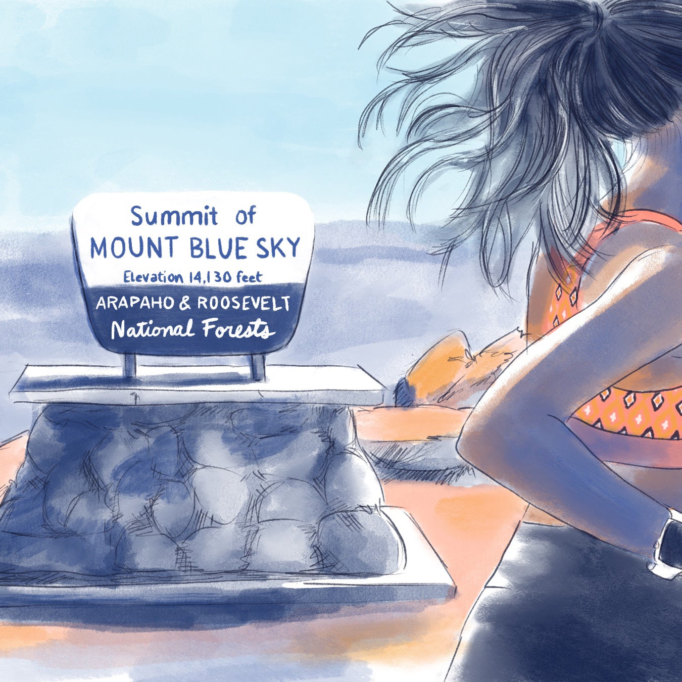
There is, of course, always resistance to changing names. C’Bearing works with a group of to push the state of Colorado to , a mountain titled after the state’s former governor. Evans instigated and covered up the 1864 , which was one of the worst massacres of Indigenous people in U.S. history. Evans was later forced to resign over his role in the atrocity. The proposed new name is Mount Blue Sky. C’Bearing says that other tribes called the Arapaho the “Blue Sky People,” but the name also has significance for a variety of Indigenous communities in the area.
C’Bearing has heard many reasons why people are against renaming but believes this resistance can be overcome through Indigenous-led conversation, education, and cooperation. As part of the renaming effort, C’Bearing and other activists are working to educate Colorado citizens about the Sand Creek massacre and the violent history of colonization. “Our history book is the land,” C’Bearing says.
“Colonial cartographies were essentially a tool toward our genocide and trying to wipe us off of the earth.”
Mountains and other landmarks are often at the center of these debates. There is Denali, which was previously known as Mount McKinley, in Alaska, ˛ą˛Ô»ĺĚýDevil’s Tower in Wyoming, a popular climbing spot with a name that many local tribes and Indigenous groups say is offensive. According to Luckasavitch of Native Land Digital, because of the often painful history, there is a very real impact for Indigenous people when they see these names on a map. “Colonial cartographies were essentially a tool toward our genocide and trying to wipe us off of the earth,” she says.
Trail and course maps that replicate this colonial violence not only continue to make Indigenous people feel unwelcome in outdoor spaces but also actively contribute to the ongoing persecution they face. C’Bearing and her office are using GIS mapping to help reverse that harmful trajectory. Through the digital mapping tool, they are following the Arapaho people’s journey across the country from the Great Lakes area, where the Arapaho origin story says they came from. Resurfacing and sharing this essential history, she believes, will raise awareness in the general public and empower Arapaho people through their own stories. C’Bearing is also helping national parks create story maps that include Indigenous names, a subtle but consequential way of reminding visitors that they are on Indigenous land. Yellowstone National Park is expected to premier its new maps for its 150th anniversary next year. C’Bearing and her office are also collaborating with Rocky Mountain National Park. These efforts are crucial not just to changing maps and trail signs, but also to empowering Indigenous nations to assert their sovereignty and make their claim to stolen land.
Reflecting on the forced colonial understanding of territories and boundaries, Jennings says, “We never agreed to have this relationship with this land.” Renaming, land acknowledgements, community building, and Indigenous-centric maps now offer a chance to reset that relationship on Indigenous terms.