Tagging technology now allows anyone with a computer or mobile device to follow the movements of great white sharks.
Along the East Coast, people are tracking Mary Lee and Genie, two great whites. A group named captured and tagged the sharks off the coast of Massachusetts . Each time, they baited a hook, hauled the shark aboard a specialized
platform, put a pipe in the animal's mouth that streamed running water through the gills, drilled holes through the dorsal fin, attached a SPOT tag, and let the predator go. Their tagging methods attracted some controversy. Environmentalists filed a on change.org asking for Ocearch's permit to be rejected. They said tagging methods that involved hooking and lifting sharks out of the water could cause harm. A September mentioned that one shark tagged by Ocearch during a South African expedition died. The Ocearch crew brought scientists on board in Massachusetts to monitor the sharks, and sucessfully tagged and released the two sharks. Now, whenever one of those shark's fins breaches, a signal is sent to a satellite and then on to the . The locations of the sharks show up on an interactive map.
On the West Coast, people can follow the comings and goings of even more great whites. In 2012, Scientists at the
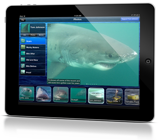
created an app called that lets users watch the predators as they swim
off the coast of California. Those animals were tagged as part of the Global
Tagging of Pelagic Predators () marine research program, and the scientists behind it published one of the first major papers on the satellite tagging of white sharks . Since 1999, GTOPP has
applied 189 acoustic tags and 148 PAT tags to great white sharks, of which perhaps 100 are currently active. They applied the tags by dragging a seal-shaped decoy near a small boat to
lure sharks in, then attached the devices to the sharks' backs using a long pole.
The two types of tags work in different ways. The PAT (Pop-up Archival Transmitting) tags cost roughly $4,000
and log information as a shark swims. The tags eventually pop off the shark and
float to the ocean’s surface where the data is transferred to a satellite—that
information doesn’t transmit in real time like Ocearch tags. The acoustic tags
cost about $300 to $500 and sound a ping every 30 to 90 seconds as the shark swims. A network of buoys and a floating drone called a along the California
coast register those pings when the sharks pass within roughly 1,000 feet. The
Wave Glider, which was recently taken out of the water, and one of the buoys
near Año Nuevo record real-time information that goes into the app. The data from the five other buoys is uploaded manually every week and then applied to the app as it comes in. In Shark Net, the locations appear on an interactive map, and are sometimes accompanied by videos and photos of individual sharks—in case you want a closer look at how “Tom Johnson” appears in the water.
This is the fourth dispatch in a series about sharks.
Part 1: Surviving a Great White Shark Attack
Part 2: George Burgess on the Science of Shark Attacks
Part 3: George Burgess on Shark Finning and Conservation
—Joe Spring