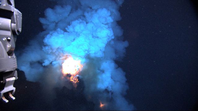
In 2009, scientists on a cruise in the Western Pacific sent a remotely operated vehicle 4,000 feet below the ocean surface and discovered a two-mile high volcano called West Mata erupting 2,200-degree Fahrenheit lava in bursts scattered over the area of a football field. It “looked like the 4th of July, underwater,” of NOAA’s Pacific Marine Environmental Lab.
Now, scientists want to share that phenomenon live. NOAA is to survey a wider swath of the region known as the Northeast Lau Basin to try to find additional volcanic activity and varied signs of life. They will do all this using the Quest 4000, a remotely operated vehicle that can dive 12,000 feet below the surface and map geology, sample chemicals, and collect biological specimens. All of those things are great for gathering data, but for pure entertainment value, what really matters is the video camera that will livestream the action. The Northeast Lau Basin is one of the most volcanically active places on the planet. It is the rare undersea location where ocean plates both separate and come together, a phenomenon that offers a smorgasboard of steaming, spouting, and erupting spots.
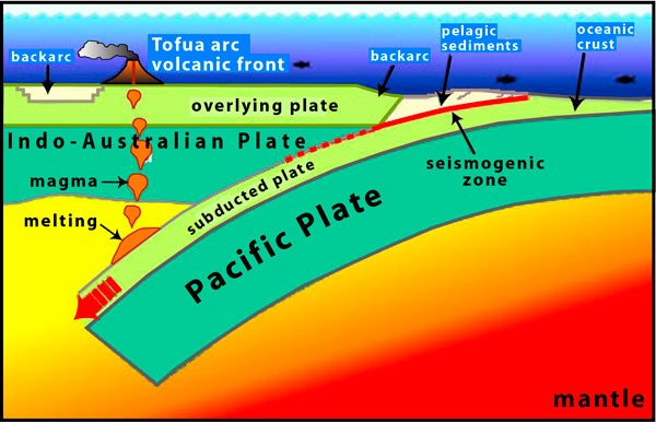
Subduction zone at the Northeast Lau Basin. Photo:
The ocean floor is made up of giant slabs of rock called tectonic plates. The plates have beginnings and ends. The beginnings are long-lined volcanic regions called mid-ocean ridges where the earth's crust thins and lava rises up through an opening. As more lava comes up, it pushes out to either side of the ridge, spreads, and hardens. The plates of rock move out from these mid-ocean ridges until they meet another plate. The ends usually occur at volcanic regions called subduction zones, where one plate moves beneath another plate on its way into the earth's mantle. (The ends may also occur at faults, areas where the plates move past each other side by side.)
Primarily, volcanic activity at the Northeast Lau Basin results from a subduction zone. The west-moving Pacific Plate moves under the Indo-Australian Plate. The friction from the rock going down into the mantle creates heat. Some of the rock melts into magma that rises up into pools. When the pools get large and hot enough, they rise up through the earth's crust to form erupting volcanos. There are hundreds of such volcanos in the Lau Basin. For some reason, the Indo-Australian Plate also pulls apart west of the volcanoes, creating something called a backarc, a thin layer of crust where there is an increase in volcanic and hydrothermal activity. It is a lesser version of a mid-ocean ridge. Scientists know the thinning is caused from stresses between the two plates, but on this cruise they are about why it is happening.
We've included a bit more on the expedition below so you read more about the science—and included links so you can watch live narrated videos of lava, ash, and gas hitting cold water.
WHO: An international team of 35 scientists led by Dr. Joseph Resing of and the University of Washington’s Joint Institute for the Study of the Atmosphere and Ocean.
WHERE: The Northeast Lau Basin, an area of the seafloor in the Western Pacific centered between Samoa, Fiji, and Tonga.

, a nine-mile-wide circular caldera that may have caused a tsunami during eruption. Photo: Susan Merle/OSU/NOAA
WHY: To map one of the most active underwater volcanic regions on earth and take samples in order to see what's living in this volatile deep-sea ecosystem. The Quest 4000 will collect animals, microbes, rocks, fluids, and gases. The material will help scientists further understand seafloor geology, but could also eventually have practical applications in areas like the pharmaceutical industry. New species might be found near seafloor vents. Giant calderas formed from explosive eruptions about past tsunamis. In short, it's a rich area for discovery. “The Lau Basin is one of Earth’s most geologically active areas, with
ocean plates colliding and separating at some of the highest rates on
the planet,” . “Our preliminary surveys between 2008 and
2011 revealed the Northeast Lau Basin as one of the most concentrated
areas of active submarine volcanism and hot springs found anywhere on
�������ٳ�.”
FOLLOW: By watching live video at . The 12-hour daily broadcasts begin at 3 p.m. EST and run from now until September 25. The scientists also post on their latest location, with maps, pictures, and summaries of what they've discovered.
—Joe Spring