

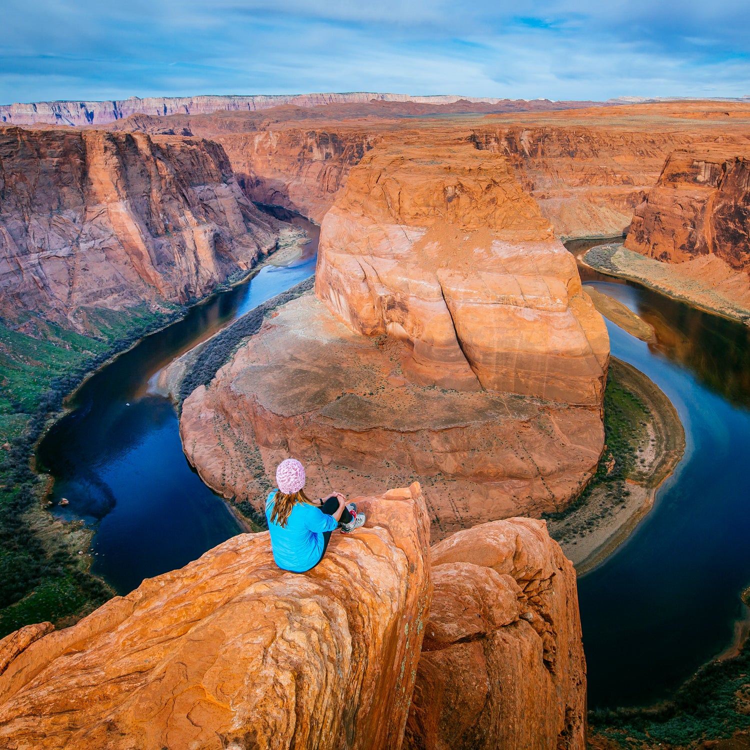
Imagine you’ve just stepped off an air-conditioned tour bus. Maybe you came from Las Vegas, so you’ve been on the road more than four hours, napping on the plush seats and watching the desert zip by. Now you and your 50 or so tour companions have arrived at the packed parking lot for Horseshoe Bend, about ten minutes from Page, Arizona. You’re eager to take in the sweeping view you’ve seen in countless photos, excited for the chance to gaze down the 1,000-foot cliff to where the Colorado River turns a dramatic 270 degrees around a sandstone escarpment.
Maybe it’s July, a busy time here, and the 115-degree heat begins to hit you. But it’s only three-quarters of a mile to the canyon rim. Surely you don’t need water. Surely you can make it in your flip-flops.
Or maybe not. Craig Janicki, a supervisory park ranger, has personally responded to dozens of emergency service calls at Horseshoe Bend Overlook, most for heat stress or heat stroke—the result of people not drinking enough water, overexerting for their abilities, or both—as well as a few trips and short falls. When people step off those buses, he says, “the level of preparedness is probably not what it should be.”
Roughly five miles south of Glen Canyon Dam and just off the area’s only highway, the spot is both stunning and irresistibly easy to reach. “It’s hard to put a finger on exactly when it became discovered,” says William Shott, superintendent of Glen Canyon National Recreation Area. As recently as five years ago, Horseshoe Bend was still somewhat of a local secret. With visitation in the thousands over the course of a year, it was still possible for visitors to get lucky and have the rim completely to themselves. But National Park Service staff noticed a drastic spike in 2015 and early 2016. In 2017—the first year visitation was officially tracked—the trail drew more than 1.3 million people—close to 4,000 a day.
Like many beautiful and Instagrammable natural attractions, Horseshoe Bend has become so popular that it’s at risk of being loved to death, as . Because of its rapid growth in visitors in such a concentrated geographic area, Shott says, Horseshoe Bend has become “a little microcosm of what we’re seeing throughout a lot of, if not all of, the National Park Service.” Namely: bigger crowds of less experienced, less prepared visitors, combined with strained resources, making for more emergencies.
The phenomenon of Instagram and other social media driving up visitation is happening on public lands nationwide, in national parks like Grand Teton and Denali, and even in some difficult-to-reach spots like Colorado’s . That trend is especially pronounced at Horseshoe Bend, which, in this time of selfies and filters, has become a must-see for tour buses and families tracing a Southwest road trip route promoted as the . “Everyone wants to tag these places,” Shott says. The iconic view also pops up constantly in marketing materials—including, as Pam Rice, assistant superintendent at Glen Canyon, points out, in . “They must not realize Horseshoe Bend is in Arizona,” she quips. (It appears to have since been removed from the site.)
Like many beautiful and Instagrammable natural attractions, Horseshoe Bend has become so popular that it’s at risk of being loved to death.
Particularly because of its accessible location, the area now faces a slew of predictable problems: trash, improper disposal of human waste, resource damage from off-trail wanderings. But particularly troubling is the upsurge in emergency medical calls. According to the Park Service, in 2012 and 2013, there were no EMS incidents at Horseshoe Bend Overlook. In 2014, there were seven, and there were 17 in 2015. By 2016, when visitation soared and record-high summer temperatures persisted for weeks, that number spiked to 56.
The increase in medical emergencies was alarming but not surprising. “More people, more incidents are going to happen,” as Janicki puts it. And it’s roughly in keeping with national statistics. In 2013, the Park Service counted 34 emergency calls per million visitors. What’s striking, though, is that the number of calls rose so swiftly in a relatively small and accessible geographic area, as opposed to the more remote backcountry areas, where the risk of emergency is typically higher. It’s a statistic that says less about the danger of the area and more about the people who visit it.
To accommodate the flood of Horseshoe visitors and make the rim trail safer and more accessible, the Park Service and the city of Page are working together to build a new trail, complete with an American Disabilities Act–compliant safety railing, at the rim, as well as two shaded structures where people can stop and cool down along the way. (Half the trail lies within Glen Canyon National Recreation Area, while the other half belongs to the city.)
Shott describes the existing route as “kind of a mar on the landscape.” It’s 20- to 30-feet wide, created by droves of visitors making a beeline straight over a hill to the overlook. “It’s like walking on an uphill sandy beach,” Shott says. The new trail, in addition to being sturdier and narrower, will go around the hill and be far less steep. At a time of tight budgets, the city and the Park Service worked to fast-track this construction, getting from planning and public input to groundbreaking in about a year. The construction, which began last fall, is expected to be completed by July 2018.
In the meantime, the Park Service has already made some changes to make the area safer. It has increased Park Service presence and set up flashing marquees to remind visitors to carry water and wear appropriate footwear. Those two small adjustments seem to be making a difference. Last year, the number of medical emergencies went down by half, to 28. (There was one fatality during this time span—a suicide.) But the seeming ease of traipsing down a short trail right off the highway still entices many of the unprepared. Mary Plumb, the recreation area’s public information officer, recently saw a woman set out in a pair of open-toed high heels. “We still have people all the time who don’t manage their own behavior and get in trouble.”
Not everyone appreciates the updates. Some people call this modernization the end of Horseshoe Bend Overlook. Yet the reality, Shott points out, is that the wilderness experience at Horseshoe Bend disappeared a long time ago. Adventurous visitors could easily visit a dozen other spots at least as spectacular as the one right off the highway. “If you want a wilderness experience where you can look down on a ‘horseshoe bend’ and get that feeling that we all love, that you’re the first one to see it,” Shott says, “come to me and I’ll show you a few places on the map.”