ϳԹ

Kevin Fedarko at the Grand Canyon’s Toroweap Overlook; exploring a side drainage within the canyon
(Photos: Pete McBride)
Kevin Fedarko at the Grand Canyon’s Toroweap Overlook; exploring a side drainage within the canyon
Kevin Fedarko at the Grand Canyon’s Toroweap Overlook; exploring a side drainage within the canyon (Photos: Pete McBride)

I Photographed Every Mile of the Colorado River. Here’s What I Learned.


Published: 

More than 15 years ago, Pete McBride set out to document all 1,450 miles of the threatened waterway. He captured its beauty and multiplying challenges, and his images underscore why its preservation is essential to us all.


New perk: Easily find new routes and hidden gems, upcoming running events, and more near you. Your weekly Local Running Newsletter has everything you need to lace up! .

On a warm April morning, I gaze at a ghost tree towering above me. Its leafless canopy seems to be staring up as well, in similar disbelief, at the 500-foot-high sandstone cliffs surrounding us.

There’s a cluster of 70-foot-tall cottonwoods on this river-bottom spot, dead for decades yet seemingly frozen between the worlds of the living and the dead. Their trunks are black and encrusted with white sediment, but somehow this ancient desert forest is still standing—like a phantom reminder of what we’ve lost.

The base of the tree trunk is swallowed by oozing, fine-grained silt that matches the palette of the walls. This cliffed cathedral is hidden inside a drainage arm of the Escalante River, which flows south into Glen Canyon, and for much of my life until recently, the grove at its base was underwater, submerged beneath what used to be a northern reach of Lake Powell, the second largest reservoir in the United States.

As of November, Lake Powell was 37 percent full—unnervingly dry, but significantly up from its record 22 percent low in spring 2023.

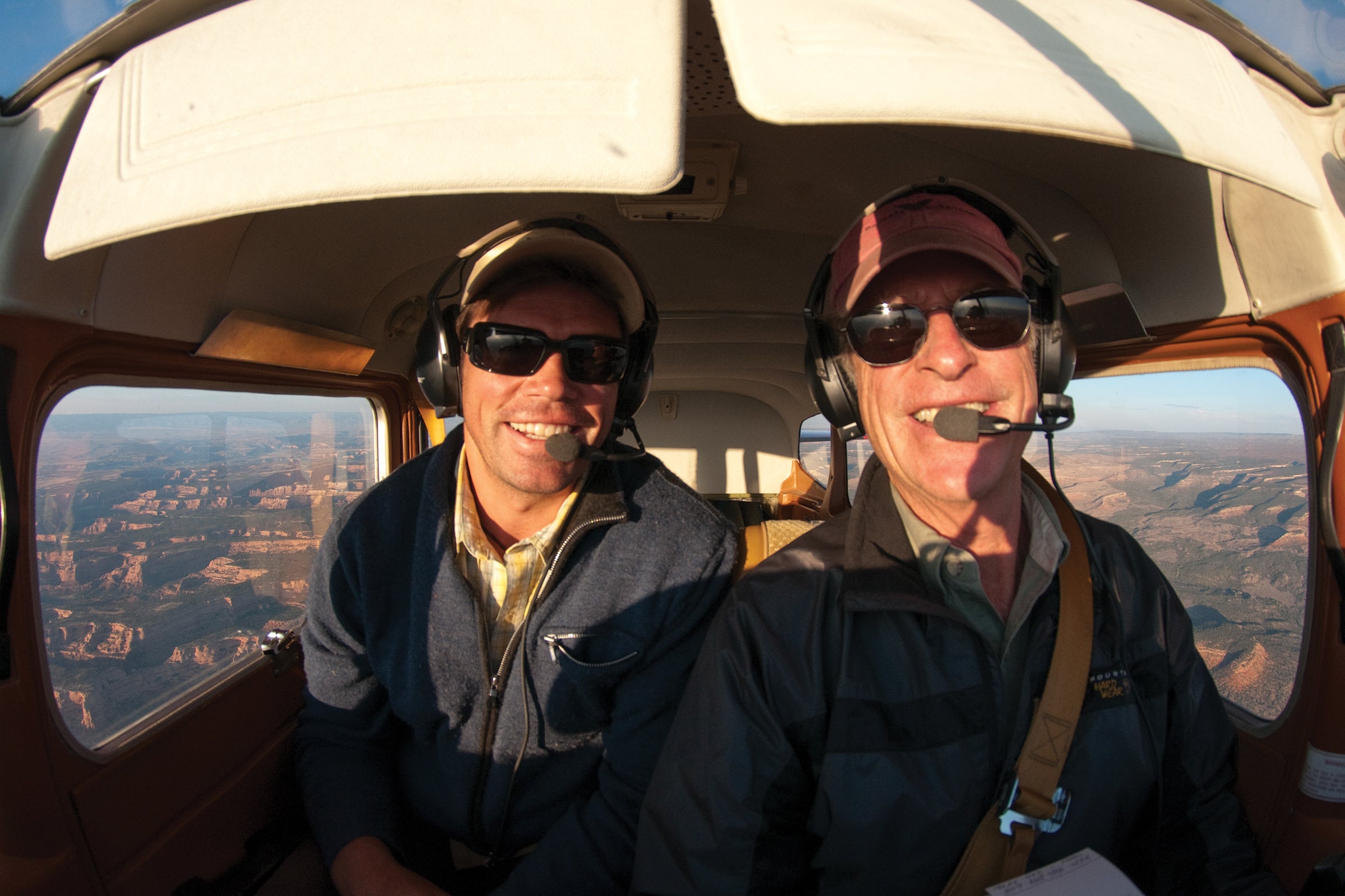
What amazes me most is that I’m walking in roughly the same path that my father, John McBride, did more than 50 years ago. I’m sure about my location because I’ve studied the old Super 8 footage he shot with his Beaulieu in 1968. The soundless clips show my father and a few pals joyfully exploring this same side canyon, which is at nearly the exact same level it is now. This was a few months before it was all drowned, and three years before I was born.

They wanted to see what nature photographer Eliot Porter called “the place no one knew” before it completely vanished. Of course, Indigenous people had lived throughout this region for centuries and knew these labyrinths intimately. But few non-Natives—relative newcomers—did. And so, during America’s dam-building era, when the Bureau of Reclamation put nearly every western river in its sights, the government flooded Glen Canyon behind the 710-foot-high wall known as Glen Canyon Dam. Little thought was given to what might happen to the river and its hydrologic cycles, habitat, and archaeological wonders.

I’ve known this river my entire life. I grew up near its headwaters and learned to swim in alpine lakes and tributaries fed by Rocky Mountain snowmelt.

Seeing the same trees my father did is weirdly sad and joyous. Lines of cement-colored silt and sediment, known as the bathtub ring, mark the walls around me. On the canyon floor, partially buried recreation detritus—beer cans, golf balls, lawn chairs, even a sunken Jet Ski—add to the time-
capsule experience.

Len Necefer, a friend, documentary filmmaker, and member of the Navajo Nation, is with me today. He walks over and casually says, “Wild. The canyon is returning. Nature bats last.”

“I guess so,” I say. “Especially when you’re playing with deep, geologic time.”

I think about what my father saw more than half a century ago. These days his memories of that adventure are murky, but his grainy old footage is profoundly revealing. It shows these same trees thriving, with grassy meadows around them. Indigenous structures are perched on cliffs, and lush springs create dancing waterfalls that spill into green alcoves. He and his friends appear equally vibrant—running, laughing, jumping. My dad looks tan and strong, his mood carefree.

It’s as if the Colorado and my father loosely reflect each other: Back then they were both wilder. Today both have been slowed.

Hoover Dam, on the Nevada-Arizona border
Hoover Dam, on the Nevada-Arizona border (Photo: Pete McBride)
Colorado’s Mount Sopris, whose snowmelt feeds the river
Colorado’s Mount Sopris, whose snowmelt feeds the river (Photo: Pete McBride)

I’ve known this river my entire life. I grew up near its headwaters and learned to swim in alpine lakes and tributaries fed by Rocky Mountain snowmelt. And I’ve spent a lot of time with my father looking at it. When I was a kid, we had a family cabin in the town of Silt, which is nestled beside the river between Glenwood Springs and Rifle. I loved fishing from the Colorado’s banks and canoeing its whiskey-colored flows, marveling at the quiet power hidden beneath the surface’s lazy appearance.

Later I would hone my swimming skills in those sneaky-fast waters. After working in the hot western Colorado sun with my brother, loading hay by hand, we would jump in to wash the dust off. No matter how hard we stroked and kicked, we got flushed hundreds of yards downstream.

It was my father who sparked my years-long project to photograph the Colorado from its start near the central Rockies to its delta terminus just shy of the Gulf of California. After I had spent a decade working as an adventure photojournalist around the world, I craved a story closer to home. In 2007, I returned to the high-country ranch we moved to in the early 1980s, near the town of Basalt, Colorado.

By then my dad, a lifelong pilot, had figured out how to take off and land using our hayfield as his strip. He invited me to go on a flight—ostensibly to “look for cows” hiding in brushy backcountry, but once we took off, his voice came through loud on my headset.

“Why don’t you do a project here?” he asked, out of the blue. “From the air, you can see how damn dry it’s getting… everywhere. Do a project on water.”

As he banked the plane I looked at him, shrugging with my eyes. But he was right. It was time I focused on our backyard. Initially, I think my father pitched the idea to see his son more, but he’d also noticed, like many, that the snowpack above our land was changing, accumulating less and melting faster. The runoff flowed more unpredictably, lurching between droughts and flash floods—the watershed trending drier.

The Colorado River delta in Mexico
The Colorado River delta in Mexico (Photo: Pete McBride)
A drought-afflicted part of Lake Mead
A drought-afflicted part of Lake Mead (Photo: Pete McBride)

In the spring of 2008, I began following our irrigation supply as it returned to the creek, then to the Colorado. And I recruited the best aerial photographic platform I could afford: my dad and his single-engine Cessna 180. We struck a deal. I reimbursed him for fuel and maintenance, while he donated his time and bush-pilot skills. Taking off from his bumpy grass strip at 7,900 feet, we flew over the Colorado River watershed, focusing mostly on the upper basin, seeking images that caught the eye and documented drought, drying, and change.

In the headwaters, we sometimes clawed our way three miles above sea level and gazed down on snow-shrouded 14,000-foot peaks, where creeks are born. During a flight in late 2012, barely an inch of snow covered the hills, making even famous crests like the Maroon Bells, a pair of postcard-worthy fourteeners near Aspen, look naked and thirsty.

On a few calm mornings we flew low and slow, chasing the river. Between getting bucked by wind shear and fleeing bumpy cumulus clouds, we saw clearly how a single, mighty ribbon of life, the Colorado, could provide so much for so many.

In western cities like Phoenix, Denver, and Las Vegas, the Colorado provides 40 to 90 percent or more of the water that pours out of residents’ faucets. In all it supplies drinking water to 40 million people in the Southwest. On paper at least, 22 of the 30 federally recognized tribes in the Colorado River basin hold rights to over 25 percent of the river, but much of those rights remain untapped. The biggest straw sucking water out of the river: agriculture. There are more than four million acres of irrigated farmland in the Colorado River watershed, producing as much as 90 percent of America’s vegetables and greens during the winter months. The river’s impact is astonishing. In 2012, its economic activity contributed $1.4 trillion to the Colorado Basin region, equivalent to approximately one-twelfth of the GDP, a share that has likely remained the same across just six states and seven California counties.

The author (left) and his father, John McBride, in the air over Utah
The author (left) and his father, John McBride, in the air over Utah (Photo: Pete McBride)

From the air, you can clearly see the web of tributaries feeding one another and the main river stem. Even clearer are the dams, diversions, and growing subdivisions—changing the landscape and shrinking not just reservoirs but the river itself.

We are now in our third decade of drought, and climate experts say the situation can no longer be considered temporary. Either way, the west is the driest it has been in 1,200 years, judging by tree-ring patterns.

With each project that pulls me downstream or upstream, I spread the word that the Colorado and its finned, feathered, and clawed friends deserve water as much as our faraway spigots do.

After seeing so much, especially from my father’s aerial vantage, one lesson has become glaringly obvious: when we ask too much of a limited resource, it disappears.

Cropland in California’s Imperial Valley
Cropland in California’s Imperial Valley (Photo: Pete McBride)
A member of Arizona’s Havasupai tribe
A member of Arizona’s Havasupai tribe (Photo: Pete McBride)

During a journey in December 2008, with writer Jonathan Waterman—almost entirely on foot, to what remained of the river’s once glorious estuary—we trudged the now dry and cracked delta from the U.S.-Mexico border to the sea, a 90-mile slog that nearly broke my back.

It definitely broke my spirit. I had never realized the scars we left on this river—even in my own lifetime—until I saw it run dry before my eyes. The river ended in a frothy, flotsam-filled Frappuccino pit littered with plastic bottles. I was floored.

But a few years after that thirsty hike with Waterman, I found hope not far from the same spot. Thanks to the hard, quiet work of a handful of conservationists, a pulse flow of roughly 105,000 acre-feet of water—just under 1 percent of the river’s annual throughput—was released into the delta in 2014 to help restore habitat and mimic historic floods. A few fellow river lovers and I paddled that eight-week flow to the Gulf of California, as the river restored pockets of the delta. Little did I know that we’d be the last souls to paddle the Colorado all the way to the sea. (Rowan Jacobsen wrote a classic ϳԹ story about it, which ran in the magazine as “The River Was Everywhere and Nowhere.”)

The tragedy of the commons continues in plain sight: new developments get started without long-term water plans. We save in one area and add water-intensive growth next door.

In 2021 and 2022, smaller pulse flows brought pockets of the delta back to life and, with the help of irrigation canals, connected it to the sea once more. Today several restoration sites serve as small reminders of what the delta once was, and could be in the future.

After my delta forays, the river called again. Over the course of 14 months, with my friend Kevin Fedarko—a writer who loves the Colorado as much as I do—I scratched through the entire length of the Grand Canyon: a 750-mile, tip-to-tail trek between river and rim on foot. We wore through eight pairs of shoes and struggled with navigation, thirst, hunger, illness, injury, and fatigue as we pondered the marvel of that outdoor geological classroom and the river that carved it.

We also became acutely aware of the value of water. Every day as we made miles—15, on average—we searched for springs, rain potholes, and seeps to collect at least a gallon each for survival. Since then I consistently marvel at the fact that, according to the EPA, the average American household uses 300 gallons of water per day.

Some western cities, like Denver and Las Vegas, have bolstered conservation by creating initiatives such as doing away with front lawns, recycling gray water, and generally raising awareness. Between 2002 and 2021, southern Nevada cut Colorado River water usage by 26 percent even as the area’s population grew. Denver Water claims that, on average, single-family residential customers use as little as 50 gallons per person per day.

The confluence of the Green and Colorado Rivers inside Utah’s Canyonlands National Park
The confluence of the Green and Colorado Rivers inside Utah’s Canyonlands National Park (Photo: Pete McBride)
The city of Phoenix, which receives Colorado River water via the Central Arizona Project
The city of Phoenix, which receives Colorado River water via the Central Arizona Project (Photo: Pete McBride)

Of all my river adventures, few compare with the time I shared with my wingman, which allowed us to connect as friends rather than just father and son. These days my dad’s memory of those flights is blurring; the claws of aging have started to dig.

When I reflect on the Colorado River and our efforts to document it together, what hits hardest is just how short our society’s collective memory can be—not just with politics and conflict, but with natural resources like water. We take both it and our time on earth for granted.

Last year was the hottest in recorded history, but when we get one slightly above-average Rocky Mountain snowpack, as we did in the winter of 2022–23, much is forgotten. When I reflect further on recent river history, and my father’s life with it, I find haunting similarities. We have dammed, diverted, drained, overengineered, overallocated, and overwhelmed the Colorado, hobbling one of the greatest rivers in the world—all during his 86 years. As my father moves into the winter of his life, we seem to have forced the Colorado River to the same stage.

I have witnessed many hard-fought efforts to conserve the river’s flows. Often they’re quiet, rather remarkable closed-door negotiations between water users who don’t always see eye to eye—ranchers and outdoors people, towns and power plants. With little fanfare, and frequently at the last minute, they coordinate needs and uses to keep enough water in the Colorado River system for trout or for a threatened native fish like the humpback chub that few will ever see. Such work creates hope—the earned kind that results when something happens beyond social media hashtag campaigns.

But at the same time, the tragedy of the commons continues in plain sight: new developments get started without long-term water plans. We save in one area and add water-intensive growth next door.

After seeing so much, especially from my father’s aerial vantage, one lesson has become glaringly obvious: when we ask too much of a limited resource, it disappears.

Many users do their best to stay under or within their legal water rights on the river. The upper basin states have been leading the charge. But many downstream still demand their allotments, granted more than 100 years ago, when the river was estimated to have roughly 20 percent more water than it actually does.

In parts of Arizona and in California’s Imperial Valley, I’ve seen farms grow ten to twelve cuttings of alfalfa hay for export to Saudi Arabia or China. That kind of water-management math doesn’t add up.

As they say, water flows uphill to money. Now the Colorado River flows overseas in the form of alfalfa.

In the spring of 2023, after almost a year of bickering and intense negotiations, California, Arizona, and Nevada proposed a landmark deal in which the federal government would pay about $1.2 billion to irrigation districts, cities, and Native American tribes to use less water through 2026, temporarily reducing consumption by roughly 13 percent in the lower basin. That’s a start, but as Taylor Hawes, the Nature Conservancy’s Colorado River program director, told me, it isn’t enough. “It’s a Band-Aid on top of a Band-Aid on top of a Band-Aid,” she said. “We need to turn our attention and energy to developing long-term plans for the health and sustainability of this river.”

I doubt my father will see the Colorado as he knew it ever again—brimming with life and water. I’m not sure I will, either. But if nature keeps batting last, we will continue to see ghost forests emerge as a river and the civilization we built struggle to find balance in the short term. The question is, at what cost?