

║┌┴╧│╘╣╧═Ї’s 10-Step Guide to Mountaineering Greatness
Perhaps you’ve made it up one of the easier, less technical summits and wondered how to take it to the next level, and beyondтАФfrom challenging walk-up to serious purple mountain majesty. Our ten-step crash course of classic American climbs will turn intermediate peak-baggers into bona fide alpinists. From Half Dome to McKinley, meet the best teachers in the business, progressively ratchet up your skill set, and graduate at the top of the continent.
Half Dome:╠¤Exposed Hiking
Image
Yosemite National Park, California
Summit Elevation: 8,842 feet
Total Elevation Gain: 4,800 feet
Duration: One Day
Snapshot: A demanding walk-up in the heart of America’s climbing capital
Yosemite is the epicenter of American climbing. One glance at California’s granite Eden proves why legendary rock rats like Royal Robbins, Warren Harding, Yvon Chouinard, Lynn Hill, Ron Kauk, and Jim Bridwell have called this place home. Don’t worry: We’re not going to scare you senseless by recommending an assault on Half Dome’s Northwest FaceтАФthe famous route pioneered in 1957 by Robbins and his buddiesтАФright out of the gate. Your mountaineering curriculum begins with a modest but challenging scramble up the relaxed side of Half Dome, a 4,800-vertical-foot ascent topping out on the roof of the park. If the views here don’t ignite your passion, might we suggest bass fishing? If, however, you’re suddenly overcome by a vision of your trail-hiking self morphing into a seasoned technical alpinist who knows his adze from a hole in the ground, then brace yourself for a lifetime of high-mountain thrills. Half Dome will introduce you to fundamentals like pacing, cardiovascular conditioning, and exposureтАФbasics that apply to all the climbs that follow. Just don’t blame us if you feel the need to move to Yosemite. As Royal Robbins once said, “climbing isn’t just a sport; it’s a way of life.”
The Route:╠¤Thunderstorms are notorious for smacking Half Dome’s summit by midafternoon, so depart by 6 a.m.a.m. to get up and down the Cables Route before the fireworks start. From the Happy Isles shuttle stop in eastern Yosemite Valley, the 16.4-mile round-trip passes the cool mists of Vernal and Nevada falls, and ambles through red firs, Jeffrey pines, and alpine meadows carpeted with wildflowers in late spring. Switchback steeply up through the conifers, repeating (to yourself, please) the mountaineer’s mantra: “unhurried haste.” The homestretch takes you up 800 vertical feet of exfoliated granite, where you’ll be aided by carved steps and a cable handrail. Here, on 45-degree slabs that would otherwise require a rope, harness, and rock protection, you’ll get your first taste of big-mountain exposure. Test your stamina by pushing up to the 8,842-foot summit: a 16-acre pulpit with 360-degree viewsтАФincluding a stirring prospect of El Capitan across the valley. Feeling cavalier? Peer over Half Dome’s sheer granite face to the valley floor almost 5,000 feet below. By the time you finish the last climb on this list, you’ll be skilled enough to consider fixing your own route up that vertical wall.
Guides:╠¤The 30-year-old , accredited by the American Mountain Guides Association, runs trips up Half Dome and many other peaks in the park. Guides teach pacing, conditioning, weather reading, and rudimentary mountain safety. Full-day rates are $331 per single person, $208 per person for two, $177 per person for three.
Longs Peak:╠¤High-Altitude Hiking
IMAGE
Rocky Mountain National Park, Colorado
Summit Elevation:╠¤14,255 feet
Total Elevation Gain:╠¤4,850 feet
╢┘│▄░ї▓╣│┘╛▒┤╟▓╘:╠¤╠¤One Day
Snapshot:╠¤Your first taste of thin air on a nontechnical ascent
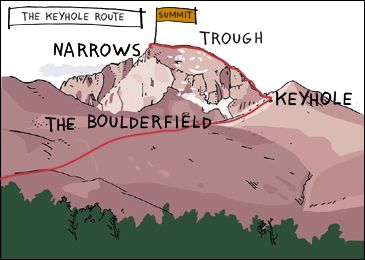
The highest point in Colorado’s Rocky Mountain National Park, an imposing pyramid called Longs Peak, towers over a cluster of incisor-sharp granite spires with names like Spearhead, Pagoda Mountain, and Sharkstooth. Longs beat back numerous summit attempts until 1868, when one-armed John Wesley Powell, who later notched the first descent of the Grand Canyon, bulled his way to the top via Keplinger’s Couloir. These days, there are 150 lines of varying difficulty established on Longs, including those up the 2,000-foot Diamond, the largest wall in Colorado. “It was my playground when I was in college,” says Tom Hornbein, who, in addition to being the first person to successfully ascend Everest’s West Ridge, has climbed Longs more than 70 times. “It has all the flavors of so many different mountains.” Fortunately, this formidable Front Range peak also has multiple walk-up routes that will test your cardiovascular limits and deliver your first real taste of altitude. Longs will also hone your ability to spot alpine lines, and before you bite into your celebratory summit sandwich, you’ll need to cultivate a climber’s steely nerve and cope with relatively safe but dizzying exposure.
The Route:╠¤When snow-free (August to early September), the 4,850-foot Keyhole Route╠¤15 miles round-tripтАФis a thrilling nontechnical walk-up that requires no rope, crampons, or ice ax. Get an alpine start by leaving Longs Peak Ranger Station no later than 2 a.m. to beat the storms and the herds of Denverites who crowd the trail all summer. Hike through pine and fir forests and vast alpine meadows up to The Boulderfield (12,760 feet). Your objective is a keyhole-like opening in the northwest ridge formed by a large overhanging hunk of granite. Slip through the hole, traverse left over a half-mile of ledges, and scramble up a long scree slope called The Trough. Ready? You’ve reached 13,850 feet, but the Keyhole’s final half-grand is the most challenging. Shimmy around a truck-sized chockstone, squeeze through a gap in the boulders, and emerge to breathtaking views on the south side of the peak. Now hitch up your Jockeys: You need to cross the knee-buckling crux called The NarrowsтАФa five-foot-wide, 200-foot-long shelf jutting out a thousand feet off the ground. Once across, let the adrenaline bath drain, and then continue up the ramp of granite slabs, thankfully riddled with edges and cracks for hands and feet. Pace yourself. Suck oxygen from the rarefied air. Just when you think you can’t go any farther, you’re on the summit.
Guides:╠¤The offers a one-day climb up Longs Peak via the Keyhole Route for $150 to $300, depending on the number of clients. The fee gets you to the top and includes a seminar on altitude-climbing skills like rest stepping (supporting your weight on the rear leg while relaxing the forward leg) and pressure breathing (blowing through pursed lips to force oxygen into the lungs), pacing, and nutrition.
Mount Shasta: Snow Climbing
IMAGE
Mount Shasta Wilderness, California
Summit Elevation:╠¤14,162 feet
Total Elevation Gain:╠¤7,212 feet
╢┘│▄░ї▓╣│┘╛▒┤╟▓╘:╠¤╠¤Two Days
Snapshot:╠¤Learn the art of upward flow on snow
At 14,162 feet, Mount Shasta so dominates the skyline of Northern California that pilots use it for navigation, New Agers feel drawn to it, and conspiracy-minded folk allege it’s a UFO base. For you, Shasta will be a thorough introduction to the world of climbing on snowтАФproper crampon technique (walking with soles that look like open Swiss Army knives isn’t as easy as you think), using an ice ax, and learning how to self-arrest. Weather-reading skills from Longs will come in handy, since Shasta’s prominence makes it a magnet for storms. In fact, John Muir, who reached the top in 1875, spent a miserable 13 hours on the summit crater’s ridge, trapped by a blizzard. He survived only by lying next to a thermal fumarole, scalding one side of himself while freezing the other. Since then, thousands have made the trip to and from the top without incident. While the technical challenges are few, knocking off Shasta will open up the frosty aeries of America’s fourteeners and other snowcapped volcanoes.
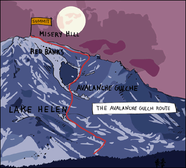
The Route:╠¤Avoid the crowds parked at Horse Camp by hauling overnight gear all the way up to high camp at Lake Helen, the scenic perch and primary staging area for those gunning up Avalanche Gulch╠¤to the Shasta summit, some of whom take the epic ski or snowboard ride back down. Soon enough, you’ll be waking up atтАФbring the coffee?тАФ2 a.m. Your route grinds steadily up a steepening 2,000-foot snowfield until you pass through a prominent band of ocher-colored rocks called the Red Banks. Just above this feature, behold the dramatic views spreading out to the north, east, and south. To the northeast? Your main objective: Shasta’s summit pinnacle. Provided the winds that routinely hammer the mountain aren’t too stiff, you’ll cross a flat shoulder then clomp up Misery Hill, a short but steep pitch and your last real hurdle. By the time you see the steam from Muir’s life-saving fumarole, you’re as good as on top.
Guides:╠¤ leads two-day climbs of the Avalanche Gulch Route ($650 per person). On day one, you’ll hike to base camp to practice self-arrest and cramponing, including the French, American, and duck steps. The next day, you’ll put the instruction into action as you attempt the summit.
Liberty Bell: Multipitch Rock
North Cascades National Park, Washington
Summit Elevation:╠¤7,720 feet
Total Elevation Gain:╠¤2,520 feet
╢┘│▄░ї▓╣│┘╛▒┤╟▓╘:╠¤╠¤One Day
Snapshot:╠¤Technical climbing thrills with backyard access
In the North Cascades, rising from the damp deciduous forests south of Washington Pass, is the immense granite dome of Liberty Bell. This classic objective adds multipitch rock climbing and a thrilling 150-foot rappel to your bag of tricks. Clip into pitons originally placed in 1946 by first-ascent artist Fred Beckey himself, the patron saint of Cascade climbing. “It has all the great challenges of an alpine climb: high altitude and elevation in a wilderness environment,” says Steve House, a big-wall vet who lives in the Bell’s shadow. Even better, the approach is a blessedly short 2.5-mile hike, just off the scenic North Cascades HighwayтАФa far sight better than Beckey’s original 16-mile slog. Now you can knock off Liberty Bell and enjoy a beer in Seattle later the same day. If only climbing gyms could be this cool.
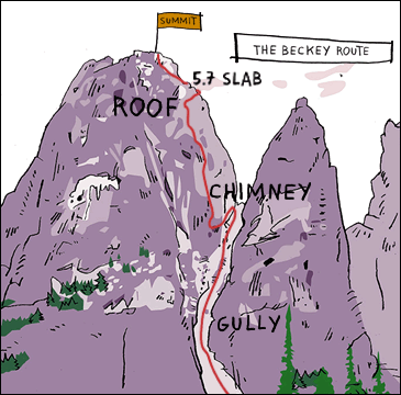
The Route:╠¤“Distinctly sporting climbing, consistently interesting, but nothing severe, on quite sound rock,” said Fred of his namesake climb, the four-pitch Beckey Route.╠¤Rated 5.7, it’s one of the best moderate rock climbs in the country, involving a full quiver of techniques: edging and chimney, crack, and friction-slab climbing. From the Blue Lake Trailhead (5,200 feet), off Highway 20, hike 2.5 miles to the north face of Liberty Bell. It’s not quite time to tie in; first you’ll zigzag up and into the gully between Liberty Bell and Concord Tower. When you reach a small tree, break out the ropes. The ascent starts easy but gets tougher as you approach a crack leading to a small roof, where the angle steepens. Clip into the fixed piton, take a deep breath, and Tarzan left to work your way around the overhang. You’ve got one more tester: a 12-foot section of 5.7 slab, greasy as pomade, that will put your footwork on full display. Once you’re clear, enjoy the 5.0 granite cakewalk to the summit at 7,720 feet. You’re now a card-carrying rock star.
Guides:╠¤ leads two-day alpine rock clinics on the Beckey Route. Spend a day going over proper belay technique, rope management, route finding, and crack, face, and chimney climbing before roping up and scaling the route yourself the next day.
Grand Teton: Multipitch Rock at Alititude
Grand Teton National Park, Wyoming
Summit Elevation:╠¤13,770 feet
Total Elevation Gain:╠¤6,920 feet
╢┘│▄░ї▓╣│┘╛▒┤╟▓╘:╠¤╠¤Two to three days
Snapshot:╠¤Lofty rock challenges on an icon of the West
The Grand Teton is often called America’s Matterhorn, and for good reason. No peak in the lower 48 rises with as much grandeur as this 13,770-foot granite-and-gneiss fang, towering over the broad sagebrush plains of northwestern Wyoming. Indeed, the Grand thrusts upward with such tectonic violence that many thought the southern ridges unattainable until 1931, when Glenn ExumтАФalone, unroped, and wearing football cleatsтАФmade the first ascent of the now legendary Exum Ridge. The feat required Exum to leap a five-foot-wide split in the rock, risking a stiff penalty if he missed: a 1,500-foot free fall. Exum backed off the climb seven times before going for it, and making it, in good style. These days, climbing the Grand is significantly safer but no less exhilarating. You’ll ascend slender ridges with pulse-spiking drop-offs of several hundred feet. “It’s real climbing with real exposure and a spectacular summit,” says Peter Lev, an Exum guide for the past 43 years. “All are ingredients that add to the sense of accomplishment one feels after climbing it.” You’ll continue to hone your craft on several pitches of moderately strenuous (5.4 to 5.7) climbing, at headier altitudes than those on Liberty Bell.
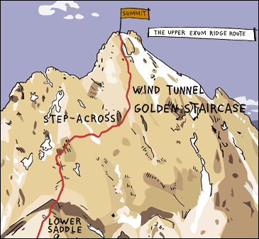
The Route:╠¤Even experienced climbers “feed the rat”тАФthat is, get their adrenaline fixтАФon the Grand’s Upper Exume Ridge Route. Hike the seven-mile Garnet Canyon Trail up to the Lower Saddle Hut, right below the Exum Ridge, where you’ll spend a short night. At first light, follow the footpath over the Black Dike, a giant horizontal band of rock, and cross the talus slopes to the base of Wall Street, a ledge where you’ll rope up and cross Exum’s famous gap, now prosaically named the Step-Across, via a hand traverse. From there, ascend the Golden Staircase, one pitch of perfect 5.4 rock. Next, surmount refrigerator-size blocks on your way through the aptly named Wind Tunnel. The final challenge is an oft ice-filled chimney that leads to the upper shoulder and the all-important payoff: the Grand’s 50-foot-long summit block, with full-circle views of Wyoming and Idaho. Once back down, treat yourself to a post-climb beer at the Mangy Moose in Teton Village.
Guides:╠¤Founded in 1926 by Paul Petzoldt and joined in ’31 by Glenn Exum, is one of the most experienced outfits in the country, with one of the world’s most impressive guide rosters: David Breashears, Pete Athans, and Miles Smart, among others. Running June to mid-September, Exum’s four-day clinic (including the Exum Ridge climb) starts with instruction in belaying, rope management, multipitch climbing, rappelling, and placing rock protection, then allows two days to scale the route.╠¤
Mount Rainier: Glacier Travel
IMAGE
Mount Rainier National Park, Washington
Summit Elevation:╠¤14,410 feet
Total Elevation Gain:╠¤8,990 feet
╢┘│▄░ї▓╣│┘╛▒┤╟▓╘:╠¤╠¤Two to three days
Snapshot:╠¤Fine-tune crevasse skills on this mighty Northwest volcano
Now that you’ve snow-climbed on Shasta and smiled at exposure on Half Dome and Longs Peak, Rainier adds glacier navigation, rope-team travel, and crevasse rescue to your travails…er, travels. At 14,410 feet, Rainier is the largest of the Cascade volcanoes, and since it’s the most heavily glaciated snow cone this side of Alaska, it’s a favorite haunt for high-altitude junkies eager to dial in their skills on demanding alpine routes. Here, you’ll get your first glimpse of expedition-style climbing, coping with altitude, cat-scratched glaciers, fierce weather, and team dynamics while heeding Seattle native and Himalayan vet Ed Viesturs’s advice: “You have to be a patient, determined machine.”
Length, height, and a battery of objective hazards make even the easiest routes on Rainier a significant challenge; only about 65 percent of those attempting this mountain each year succeed. Whether you top out or not, you’ll leave with one of Viesturs’s aphorisms burned into your brain: “Reaching the summit is optional. Getting down is mandatory.”
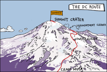
The Route:╠¤The Disappointment Cleaver, or DC, route is the most popular line to the top of Rainier. Grab a “climber’s breakfast” at the invitingly rustic Paradise Inn before the long, steady grind up the permanent Muir Snowfield. Stay on course; the edges of the snowfield can be riddled with crevasses. Some 4,500 vertical feet later, you’ll pull into Camp Muir, at 10,080 feet. Set your alarm for midnight and try to catch a couple of winks before roping up and entering the world of technical glacier travel. Above Muir, you’ll wend past yawning crevasses along the Cowlitz Glacier, tiptoe over snow bridges on the Ingraham Glacier, and duck past the giant seracs of the Ingraham Icefall. Scramble over scree and pumice to the top of Disappointment Cleaver, taking care not to kick rocks on any climbers below you. Now ease onto the Summit Dome, following the well-trodden snowy switchbacks to Rainier’s summit caldera. As the sun rises over eastern Washington, ramble across the quarter-mile-wide crater to the true summit, at the Columbia Crest. Drink in dawn views of neighboring volcanoes: Mounts Adams, St. Helens, and HoodтАФall of them easier to summit than Rainier and now within your grasp. Congratulations. You’ve just tackled your first true mountain climb.
Guides:╠¤╠¤offers a four-day program consisting of a two-day skills session and a two-day summit climb. Fine-tune thin-air mountaineering techniques like the rest step and pressure breathing, practice ice-ax arrest, and learn roped glacier travel and crevasse rescue using ascenders and Prusik slings. The next day, you’ll hike to RMI’s hut at Camp Muir, catch a few Z’s, and head out beneath the stars for the summit at 2 a.m.
Wolf’s Head: Exposed Multipitch Rock
Wind River Range, Wyoming
Summit Elevation:╠¤12,165 feet
Total Elevation Gain:╠¤3,045
╢┘│▄░ї▓╣│┘╛▒┤╟▓╘:╠¤╠¤Three days
Snapshot:╠¤A remote rock climb featuring a gutsy knife ridge
Deep inside Wyoming’s Wind River Range is a soaring granite fin that climbers everywhere consider a litmus test for raw nerve. Step up to Wolf’s Head, a razor-thin traverse so adrenaline-firing and aesthetically blessed that grizzled alpine gurus Allen Steck and Steve Roper showcased it in their seminal book 50 Classic Climbs of North America. Located in the remote Cirque of the Towers, an arena of 18 rock spires reaching above 12,000 feet, Wolf’s Head will challenge your rock skills, multipitch endurance, andтАФwhen staring at precipitous drops from the 12,165-foot summitтАФspinal fortitude. The long approach, tricky climbing, and unpredictable weather that blitzes the Cirque of the Towers will enforce efficient movement if you want to avoid an epic on this trip. In other words, by the time you hike back to the car, you’ll understand the full meaning of grace under pressure.
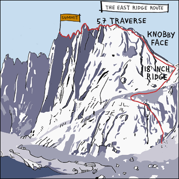
The Route:╠¤Okay, so it’s rated a deceptively modest 5.7, but ascend the East Ridge╠¤of Wolf’s Head and you’ll feel like you’ve climbed 5.10. From Big Sandy Opening, southwest of Pinedale, Wyoming, hoof a day to base camp inside the Cirque of the Towers. Set out at dawn and scramble up a gully on the east ridge to a notch below the ridgeline. Break out the chalkтАФ”white courage”тАФand up you go on mellow rock filled with pleasant surprises: a pocket here, a crack there. Pray it’s not windy, because you’re about to tightrope toward the true summit on a 1,000-foot ridge that narrows to a mere 18 inches, framed by empty plunges. Ascend Knobby Face to the real crux, a 5.7 contour around a tower lacking anything remotely resembling a handhold. (“Edging skills or hospital bills,” vets of the Wolf like to say.) Once you reach the safety of the summit block, feel free to prostrate yourself and plaster it with kisses.
Guides:╠¤ leads five-day trips into the Cirque of the Towers to attempt Wolf’s Head and other objectives, time permitting. This includes a day to make the eight-mile hike to base camp, three days of climbing on some of the best granite in the Rockies, and a day to hike back out. Guides review belaying and setting and removing rock-climbing protection like cams, nuts, and stoppers. You’ll also review and practice techniques to help you move fast on long multipitch routes, the key to avoiding stormy nights and sketchy bivouacs.
El Pico de Orizaba: Expedition Climbing with Altitude
Sierra Madre Range, Mexico
Summit Elevation:╠¤18,700 feet
Total Elevation Gain:╠¤4,700 feet
╢┘│▄░ї▓╣│┘╛▒┤╟▓╘:╠¤╠¤Nine days
Snapshot: A moderate glacier walk-up with serious altitude
It’s now time to see whether you can hold it together at mind-numbing, lung-crushing altitude, and Mexico’s El Pico de Orizaba, the third-highest peak in North America, is the perfect laboratory. Although the low-angle slopes of Orizaba may seem like a stroll compared with Rainier and Shasta, it’s a crucial step toward reaching more ambitious goals like Mount McKinley. “Orizaba gives climbers a feel for altitude and ensures they have their skills down before going higher,” says Phil Ershler, a partner in the Ashford, Washington├Рbased International Mountain Guides who regularly ventures to the volcano during winter to prepare clients for the Northern Hemisphere’s spring and summer climbing season. If you find that you thrive at altitudeтАФyou’re only mildly nauseated, and over-the-counter medication quells your headacheтАФfeel confident as you head to higher ground. If you’re not as fortunate, keep chugging water, breathe five times with each step, and be sure to mutter a heartfelt “gracias” when you top out.
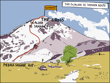
The Route:╠¤A long ride from Mexico City deposits you at the Piedra Grande Hut, located at 14,000 feet and less than five grand from Orizaba’s summit. Settle in for three days and nights of acclimatization, psyching up for the 12-hour round-trip summit day. From the hut, hike up through the barren moonscape of the lower mountain, past ancient aqueducts and cliff bands. At the head of the Glaciar de Jamapa Route╠¤(16,000 feet), you’ll don crampons, rope up, and begin the forced march to the top along an icy slope marked by the occasional 35-degree step. The highest point along a wide volcano crater is marked by a weather-beaten cross. If you can ignore the blood pounding in your temples, you’ll enjoy views all the way to the Pacific and the knowledge that you’re within 2,000 vertical feet of your ultimate goal: the top of McKinley.
Guides:╠¤ travels to Orizaba in November and February for altitude training ($2,200)╠¤before the climbing season up north begins and to teach their strategies for success at high elevation: rest stepping, pressure breathing, and a gallon of liquids a day, all of which will help you avoid scourges like cerebral and pulmonary edema, acute mountain sickness, frostbite, and hypothermia. As part of the weeklong trip, you’ll warm up on nearby Ixtaccihuatl (17,338 feet) before heading off to Orizaba.
Mount Whitney: Strenuous Multipitch Rock
Sequia National Park, California
Summit Elevation:╠¤14,494 feet
Total Elevation Gain:╠¤6,100 feet
╢┘│▄░ї▓╣│┘╛▒┤╟▓╘:╠¤╠¤Two to three days
Snapshot:╠¤Scale a big wall via an intermediate route
It’s a badly kept secret, but California’s 14,494-foot Mount WhitneyтАФnot Rainier, Shasta, or LongsтАФis the lower 48’s highest point. Hiking up its nontechnical west side is no small accomplishment, but you will soon earn serious climbing cred on Whitney’s formidable East Face. “The route requires good mountain sense,” says Chris McNamara, climber and founder of SuperTopo.com, the leading online guide to Whitney. “You need an instinct for knowing when you’re off-routeтАФit’s moderate face climbing, but the route finding is tricky, leaving you always on edge.” On this wrinkled sheet of Sierra granite, you’ll follow the handholds and footholds of Norman Clyde, Jules Eichorn, Glen Dawson, and Robert Underhill, American alpine legends who, for their 1931 first ascent, mustered “considerable steadiness, as the ledges were narrow and there was a thousand feet of fresh air below.” Once you finish, raise a toast to yourself at the Double L Bar in Lone Pine, the hangout for Whitney climbers, where you can share your tales from the mountain.
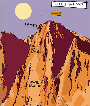
The Route:╠¤Whitney will have you ascending a total of 6,100 feet, the last 1,200 of which involve vertical, exposed, and difficult rock. The route begins auspiciously with a long, scenic haul to camp at 12,600-foot Iceberg Lake, hard by the base of Whitney’s 1,800-foot East Face. When dawn breaks red on the summit the next day, knock off the lower section by scrambling up to a granite spire to the north. The real fun begins at 13,200 feet, when you finally slip on your rock shoes, rope up, and slowly make your way across good holds and up the face proper with 800 feet of clean California air below you. Nearly smack-dab in the middle of the wall lies the crux, the Fresh Air Traverse, a tenuous path of flakes and tiny cracks and the most hair-raising 5.6 move on our roster. Spider up a chimney, then climb easy ramps and short steps to the top. But stop to enjoy the solitude and the Mars-like expanse of desert below before you top outтАФa couple hundred visitors who walked up the south side may be eating lunch right above you.
Guides:╠¤The leads three-day trips ($795 per person) on the East Face throughout the summer. To help acclimatize, spend the eve of your climbing class camping at the Whitney Portal trailhead. The next day, hike to Iceberg Lake and review the proverbial ropes: multipitch climbing, rock protection, belaying, and coping with altitude. On day two, attempt the East Face. Day three is for your triumphant return.
Mount McKinley: Himalaya-Caliber Expedition
╠¤
Denali National Park and Preserve, Alaska
Summit Elevation:╠¤20,320 feet
Total Elevation Gain:╠¤12,920 feet
╢┘│▄░ї▓╣│┘╛▒┤╟▓╘:╠¤Three weeks
Snapshot:╠¤Combine alpine, ice, and glacier skills on the roof of the continent
Ready to earn your stripes? Consider what you’ve encountered thus farтАФglacier travel on Rainier, exposure on Wolf’s Head, altitude on OrizabaтАФmere warm-ups for surly, burly 20,320-foot McKinley, the highest point in North America. “That mountain chews people up,” says Erik Weihenmayer, the first blind man to climb the Seven Summits. “You’re carrying a 60-pound pack and pulling a sled with 50 pounds of gear; the bad weather is really badтАФit’ll bury your tent and you.” Planning and training will begin months before your expedition, while the climb itself may well involve gale-force winds, sub-zero temps, punishing altitude, and arduous technical climbing in dangerous conditions. And what, exactly, is the payoff? Nothing less than an all-access pass to any mountain range in the world. Says Weihenmayer, “You’re going to carry big loads, you’re going to push through multiple storms, you’re going to have to take care of yourself, and you’re going to learn a lot. Once you’ve done it, it definitely makes you feel like you’re ready for anything.”
The Route:╠¤Pioneered by Bradford Washburn in 1951, McKinley’s West Buttress╠¤is notorious for its mind-numbing cold and tempestuous weather, but what a trip: almost 13,000 vertical feet total, one of the greatest elevation gains of any mountain in the world. After catching a bush plane to the Kahiltna Glacier, you’ll spend at least nine days hauling gear and provisionsтАФsans SherpasтАФup the crevasse-striped glacier to advance base camp in the Genet Basin at 14,200 feet. After a rest day, ascend The Headwall, a 45-degree snow slope, via fixed rope to 16,200 feet. The stretch above youтАФa mile-long catwalk along the snowy, ice-lacquered spine of the buttressтАФwill blow your mind. At the end of the ridge, you’ll make high camp at 17,200 feet, rest for a day, and then head for the summit just after midnight.
Guides:╠¤ runs 23-day trips ($7,300) on the West Buttress each year. At base camp, guides will review and perfect your crampon technique and your self- and team-arrest and crevasse-rescue skills. You’ll also review glacier travel, how to efficiently climb up fixed lines using ratcheting ascenders, and ways to avoid frostbite, hypothermia, and pulmonary and cerebral edema.
1. Half Dome
Yosemite National Park, California

* SUMMIT ELEVATION: 8,842 feet
* TOTAL ELEVATION GAIN: 4,800 feet
* DURATION: One Day
* SNAPSHOT: A demanding walk-up in the heart of America’s climbing capital
YOSEMITE is the epicenter of American climbing. One glance at California’s granite Eden proves why legendary rock rats like Royal Robbins, Warren Harding, Yvon Chouinard, Lynn Hill, Ron Kauk, and Jim Bridwell have called this place home. Don’t worry: We’re not going to scare you senseless by recommending an assault on Half Dome’s Northwest Face—the famous route pioneered in 1957 by Robbins and his buddies—right out of the gate. Your mountaineering curriculum begins with a modest but challenging scramble up the relaxed side of Half Dome, a 4,800-vertical-foot ascent topping out on the roof of the park. If the views here don’t ignite your passion, might we suggest bass fishing? If, however, you’re suddenly overcome by a vision of your trail-hiking self morphing into a seasoned technical alpinist who knows his adze from a hole in the ground, then brace yourself for a lifetime of high-mountain thrills. Half Dome will introduce you to fundamentals like pacing, cardiovascular conditioning, and exposure—basics that apply to all the climbs that follow. Just don’t blame us if you feel the need to move to Yosemite. As Royal Robbins once said, “climbing isn’t just a sport; it’s a way of life.”
** The Route
Thunderstorms are notorious for smacking Half Dome’s summit by midafternoon, so depart by 6 a.m.a.m. to get up and down the CABLES ROUTE before the fireworks start. From the Happy Isles shuttle stop in eastern Yosemite Valley, the 16.4-mile round-trip passes the cool mists of Vernal and Nevada falls, and ambles through red firs, Jeffrey pines, and alpine meadows carpeted with wildflowers in late spring. Switchback steeply up through the conifers, repeating (to yourself, please) the mountaineer’s mantra: “unhurried haste.” The homestretch takes you up 800 vertical feet of exfoliated granite, where you’ll be aided by carved steps and a cable handrail. Here, on 45-degree slabs that would otherwise require a rope, harness, and rock protection, you’ll get your first taste of big-mountain exposure. Test your stamina by pushing up to the 8,842-foot summit: a 16-acre pulpit with 360-degree views—including a stirring prospect of El Capitan across the valley. Feeling cavalier? Peer over Half Dome’s sheer granite face to the valley floor almost 5,000 feet below. By the time you finish the last climb on this list, you’ll be skilled enough to consider fixing your own route up that vertical wall.
GUIDE The 30-year-old Yosemite Mountain-eering School & Guide Service, accredited by the American Mountain Guides Association, runs trips up Half Dome and many other peaks in the park. Guides teach pacing, conditioning, weather reading, and rudimentary mountain safety. Full-day rates are $150 per single person, $90 per person for two, $80 per person for three. (209-372-8344, )
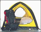
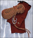
ESSENTIAL GEAR
Perfect for overnight trips, the sleek OSPREY ECLIPSE 42 expands to 2,600 cubic inches. ($169; 970-564-5900, ) Stay dry in ARC’TERYX’s SIRRUS SL Gore-Tex shell if you get ambushed by a squall on Half Dome. Watertight front, pit, and pocket zips provide extra ventilation once the sun returns. ($300; 800-985-6681, ) A pair of durable, surefooted LOWA TANARK boots will get you up the peak’s granite back side with ease. ($170; 888-335-5692, )
2. Longs Peak
Rocky Mountain National Park, Colorado
* SUMMIT ELEVATION: 14,255 feet
* TOTAL ELEVATION GAIN: 4,850 feet
* DURATION: One Day
* SNAPSHOT: Your first taste of thin air on a nontechnical ascent
THE HIGHEST POINT in Colorado’s Rocky Mountain National Park, an imposing pyramid called Longs Peak, towers over a cluster of incisor-sharp granite spires with names like Spearhead, Pagoda Mountain, and Sharkstooth. Longs beat back numerous summit attempts until 1868, when one-armed John Wesley Powell, who later notched the first descent of the Grand Canyon, bulled his way to the top via Keplinger’s Couloir. These days, there are 150 lines of varying difficulty established on Longs, including those up the 2,000-foot Diamond, the largest wall in Colorado. “It was my playground when I was in college,” says Tom Hornbein, who, in addition to being the first person to successfully ascend Everest’s West Ridge, has climbed Longs more than 70 times. “It has all the flavors of so many different mountains.” Fortunately, this formidable Front Range peak also has multiple walk-up routes that will test your cardiovascular limits and deliver your first real taste of altitude. Longs will also hone your ability to spot alpine lines, and before you bite into your celebratory summit sandwich, you’ll need to cultivate a climber’s steely nerve and cope with relatively safe but dizzying exposure.
** The Route
When snow-free (August to early September), the 4,850-foot KEYHOLE ROUTE 15 miles round-trip—is a thrilling nontechnical walk-up that requires no rope, crampons, or ice ax. Get an alpine start by leaving Longs Peak Ranger Station no later than 2 a.m. to beat the storms and the herds of Denverites who crowd the trail all summer. Hike through pine and fir forests and vast alpine meadows up to The Boulderfield (12,760 feet). Your objective is a keyhole-like opening in the northwest ridge formed by a large overhanging hunk of granite. Slip through the hole, traverse left over a half-mile of ledges, and scramble up a long scree slope called The Trough. Ready? You’ve reached 13,850 feet, but the Keyhole’s final half-grand is the most challenging. Shimmy around a truck-sized chockstone, squeeze through a gap in the boulders, and emerge to breathtaking views on the south side of the peak. Now hitch up your Jockeys: You need to cross the knee-buckling crux called The Narrows—a five-foot-wide, 200-foot-long shelf jutting out a thousand feet off the ground. Once across, let the adrenaline bath drain, and then continue up the ramp of granite slabs, thankfully riddled with edges and cracks for hands and feet. Pace yourself. Suck oxygen from the rarefied air. Just when you think you can’t go any farther, you’re on the summit.
GUIDE The Colorado Mountain School offers a one-day climb up Longs Peak via the Keyhole Route for $150 to $300, depending on the number of clients. The fee gets you to the top and includes a seminar on altitude-climbing skills like rest stepping (supporting your weight on the rear leg while relaxing the forward leg) and pressure breathing (blowing through pursed lips to force oxygen into the lungs), pacing, and nutrition. (888-267-7783, )
ESSENTIAL GEAR
Brighten up your pre-dawn start with PRINCETON TEC‘s versatile MATRIX headlamp. LED bulbs provide hours of candlepower on just two AA batteries, and a high-beam setting will keep you on course through The Boulderfield. ($40; 609-298-9331, ) PATAGONIA’s R3 RADIANT fleece jacket seals out the chill, thanks to thick pile that provides a critical layer of insulation on Longs and, later, Rainier, Orizaba, and McKinley. ($138; 800-638-6464, ) Simple yet bombproof, MARMOT’s LIQUID STEEL pants will stop wind, rain, snow, hail, and whatever else Mother Nature throws at you. ($250; 800-882-2490, )
3. Mount Shasta
Mount Shasta Wilderness, California
* SUMMIT ELEVATION: 14,162 feet
* TOTAL ELEVATION GAIN: 7,212 feet
* DURATION: Two Days
* SNAPSHOT: Learn the art of upward flow on snow
AT 14,162 FEET, Mount Shasta so dominates the skyline of Northern California that pilots use it for navigation, New Agers feel drawn to it, and conspiracy-minded folk allege it’s a UFO base. For you, Shasta will be a thorough introduction to the world of climbing on snow—proper crampon technique (walking with soles that look like open Swiss Army knives isn’t as easy as you think), using an ice ax, and learning how to self-arrest. Weather-reading skills from Longs will come in handy, since Shasta’s prominence makes it a magnet for storms. In fact, John Muir, who reached the top in 1875, spent a miserable 13 hours on the summit crater’s ridge, trapped by a blizzard. He survived only by lying next to a thermal fumarole, scalding one side of himself while freezing the other. Since then, thousands have made the trip to and from the top without incident. While the technical challenges are few, knocking off Shasta will open up the frosty aeries of America’s fourteeners and other snowcapped volcanoes.
** The Route
Avoid the crowds parked at Horse Camp by hauling overnight gear all the way up to high camp at Lake Helen, the scenic perch and primary staging area for those gunning up AVALANCHE GULCH to the Shasta summit, some of whom take the epic ski or snowboard ride back down. Soon enough, you’ll be waking up at—bring the coffee?—2 a.m. Your route grinds steadily up a steepening 2,000-foot snowfield until you pass through a prominent band of ocher-colored rocks called the Red Banks. Just above this feature, behold the dramatic views spreading out to the north, east, and south. To the northeast? Your main objective: Shasta’s summit pinnacle. Provided the winds that routinely hammer the mountain aren’t too stiff, you’ll cross a flat shoulder then clomp up Misery Hill, a short but steep pitch and your last real hurdle. By the time you see the steam from Muir’s life-saving fumarole, you’re as good as on top.
GUIDE Shasta Mountain Guides leads two-day climbs of the Avalanche Gulch Route ($325 per person). On day one, you’ll hike to base camp to practice self-arrest and cramponing, including the French, American, and duck steps. The next day, you’ll put the instruction into action as you attempt the summit. (530-926-3117, )
ESSENTIAL GEAR
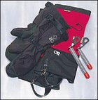
Stomp up Avalanche Gulch in KOFLACH’s ARTIS EXPE hard boots. Later, they’ll keep your toes warm—and attached—when confronting McKinley’s bitter chill. ($355; 800-258-5020, ) The ultralight chromoly-steel shaft on the GRIVEL AIR TECH EVOLUTION ice ax will withstand 880 pounds of force, more than enough to catch a slip. ($150; 801-463-7996, ) CHARLET MOSER SUPER 12 ART articulated step-in crampons handle it all: Shasta hardpack, Rainier boilerplate, and Orizaba blue ice. ($140; 801-327-3805, ) Warm hands equal a warm body, so don REI’s EXPEDITION-WEIGHT MTS FLEECE GLOVE LINERS. Line your mitts with ’em, too. ($12; 800-426-4840, )
4. Liberty Bell
North Cascades National Park, Washington

* SUMMIT ELEVATION: 7,720 feet
* TOTAL ELEVATION GAIN: 2,520 feet
* DURATION: One Day
* SNAPSHOT: Technical climbing thrills with backyard access
IN THE NORTH Cascades, rising from the damp deciduous forests south of Washington Pass, is the immense granite dome of Liberty Bell. This classic objective adds multipitch rock climbing and a thrilling 150-foot rappel to your bag of tricks. Clip into pitons originally placed in 1946 by first-ascent artist Fred Beckey himself, the patron saint of Cascade climbing. “It has all the great challenges of an alpine climb: high altitude and elevation in a wilderness environment,” says Steve House, a big-wall vet who lives in the Bell’s shadow. Even better, the approach is a blessedly short 2.5-mile hike, just off the scenic North Cascades Highway—a far sight better than Beckey’s original 16-mile slog. Now you can knock off Liberty Bell and enjoy a beer in Seattle later the same day. If only climbing gyms could be this cool.
** The Route
“Distinctly sporting climbing, consistently interesting, but nothing severe, on quite sound rock,” said Fred of his namesake climb, the four-pitch BECKEY ROUTE. Rated 5.7, it’s one of the best moderate rock climbs in the country, involving a full quiver of techniques: edging and chimney, crack, and friction-slab climbing. From the Blue Lake Trailhead (5,200 feet), off Highway 20, hike 2.5 miles to the north face of Liberty Bell. It’s not quite time to tie in; first you’ll zigzag up and into the gully between Liberty Bell and Concord Tower. When you reach a small tree, break out the ropes. The ascent starts easy but gets tougher as you approach a crack leading to a small roof, where the angle steepens. Clip into the fixed piton, take a deep breath, and Tarzan left to work your way around the overhang. You’ve got one more tester: a 12-foot section of 5.7 slab, greasy as pomade, that will put your footwork on full display. Once you’re clear, enjoy the 5.0 granite cakewalk to the summit at 7,720 feet. You’re now a card-carrying rock star.
GUIDE North Cascades Mountain Guides leads two-day alpine rock clinics on the Beckey Route. Spend a day going over proper belay technique, rope management, route finding, and crack, face, and chimney climbing before roping up and scaling the route yourself the next day. ($300 per person, or $200 per person with a group; 509-996-3194, )
ESSENTIAL GEAR
Dance through crux moves in BOREAL’s ACES. Sticky soles make short work of friction slabs, while all-day comfort keeps your feet from screaming “Mercy!” on long routes. ($150; 949-493-3464, ) The BLACK DIAMOND BOD harness is simple, reliable, and easy to enter and exit while wearing crampons. ($50; 801-278-5533, ) Protect yourself from rockfall with PETZL’s ECRIN ROC polycarbonate helmet. ($74; 801-327-3805, )
5. Grand Teton
Grand Teton National Park, Wyoming
* SUMMIT ELEVATION: 13,770 feet
* TOTAL ELEVATION GAIN: 6,920 feet
* DURATION: Two to three days
* SNAPSHOT: Lofty rock challenges on an icon of the West
THE GRAND TETON is often called America’s Matterhorn, and for good reason. No peak in the lower 48 rises with as much grandeur as this 13,770-foot granite-and-gneiss fang, towering over the broad sagebrush plains of northwestern Wyoming. Indeed, the Grand thrusts upward with such tectonic violence that many thought the southern ridges unattainable until 1931, when Glenn Exum—alone, unroped, and wearing football cleats—made the first ascent of the now legendary Exum Ridge. The feat required Exum to leap a five-foot-wide split in the rock, risking a stiff penalty if he missed: a 1,500-foot free fall. Exum backed off the climb seven times before going for it, and making it, in good style. These days, climbing the Grand is significantly safer but no less exhilarating. You’ll ascend slender ridges with pulse-spiking drop-offs of several hundred feet. “It’s real climbing with real exposure and a spectacular summit,” says Peter Lev, an Exum guide for the past 43 years. “All are ingredients that add to the sense of accomplishment one feels after climbing it.” You’ll continue to hone your craft on several pitches of moderately strenuous (5.4 to 5.7) climbing, at headier altitudes than those on Liberty Bell.
** The Route
Even experienced climbers “feed the rat”—that is, get their adrenaline fix—on the Grand’s UPPER EXUME RIDGE ROUTE. Hike the seven-mile Garnet Canyon Trail up to the Lower Saddle Hut, right below the Exum Ridge, where you’ll spend a short night. At first light, follow the footpath over the Black Dike, a giant horizontal band of rock, and cross the talus slopes to the base of Wall Street, a ledge where you’ll rope up and cross Exum’s famous gap, now prosaically named the Step-Across, via a hand traverse. From there, ascend the Golden Staircase, one pitch of perfect 5.4 rock. Next, surmount refrigerator-size blocks on your way through the aptly named Wind Tunnel. The final challenge is an oft ice-filled chimney that leads to the upper shoulder and the all-important payoff: the Grand’s 50-foot-long summit block, with full-circle views of Wyoming and Idaho. Once back down, treat yourself to a post-climb beer at the Mangy Moose in Teton Village.
GUIDE Founded in 1926 by Paul Petzoldt and joined in ’31 by Glenn Exum, Exum Mountain Guides is one of the most experienced outfits in the country, with one of the world’s most impressive guide rosters: David Breashears, Pete Athans, and Miles Smart, among others. Running June to mid-September, Exum’s four-day clinic (including the Exum Ridge climb) starts with instruction in belaying, rope management, multipitch climbing, rappelling, and placing rock protection, then allows two days to scale the route. ($695 per person; 307-733-2297, )
ESSENTIAL GEAR
Take shelter in the BIBLER FITZROY three-person tent, a sub-seven-pound single-wall design that withstands the nastiest weather ($750; 801-278-5533, ) The 15-degree MOUNTAINSMITH VISION sleeping bag trims weight to less than two pounds and stays cozy through summer and into fall. ($300; 800-551-5889, ) It’s compact, it’s stable, and it runs on almost any fuel: It’s the MSR DRAGONFLY stove. ($100; 800-531-9531, ) Don’t want to leave anything behind? Arc’Teryx’s bora 95 is a 5,500-cubic-inch pack that will swallow a garage of gear. ($395; 800-985-6681, ).
6. Mount Rainier
Mount Rainier National Park, Washington
* SUMMIT ELEVATION: 14,410 feet
* TOTAL ELEVATION GAIN: 8,990 feet
* DURATION: Two to three days
* SNAPSHOT: Fine-tune crevasse skills on this mighty Northwest volcano
NOW THAT YOU’VE snow-climbed on Shasta and smiled at exposure on Half Dome and Longs Peak, Rainier adds glacier navigation, rope-team travel, and crevasse rescue to your travails…er, travels. At 14,410 feet, Rainier is the largest of the Cascade volcanoes, and since it’s the most heavily glaciated snow cone this side of Alaska, it’s a favorite haunt for high-altitude junkies eager to dial in their skills on demanding alpine routes. Here, you’ll get your first glimpse of expedition-style climbing, coping with altitude, cat-scratched glaciers, fierce weather, and team dynamics while heeding Seattle native and Himalayan vet Ed Viesturs’s advice: “You have to be a patient, determined machine.”
Length, height, and a battery of objective hazards make even the easiest routes on Rainier a significant challenge; only about 65 percent of those attempting this mountain each year succeed. Whether you top out or not, you’ll leave with one of Viesturs’s aphorisms burned into your brain: “Reaching the summit is optional. Getting down is mandatory.”
** The Route
The DISAPPOINTMENT CLEAVER, or DC, route is the most popular line to the top of Rainier. Grab a “climber’s breakfast” at the invitingly rustic Paradise Inn before the long, steady grind up the permanent Muir Snowfield. Stay on course; the edges of the snowfield can be riddled with crevasses. Some 4,500 vertical feet later, you’ll pull into Camp Muir, at 10,080 feet. Set your alarm for midnight and try to catch a couple of winks before roping up and entering the world of technical glacier travel. Above Muir, you’ll wend past yawning crevasses along the Cowlitz Glacier, tiptoe over snow bridges on the Ingraham Glacier, and duck past the giant seracs of the Ingraham Icefall. Scramble over scree and pumice to the top of Disappointment Cleaver, taking care not to kick rocks on any climbers below you. Now ease onto the Summit Dome, following the well-trodden snowy switchbacks to Rainier’s summit caldera. As the sun rises over eastern Washington, ramble across the quarter-mile-wide crater to the true summit, at the Columbia Crest. Drink in dawn views of neighboring volcanoes: Mounts Adams, St. Helens, and Hood—all of them easier to summit than Rainier and now within your grasp. Congratulations. You’ve just tackled your first true mountain climb.
GUIDE Rainier Mountaineering Inc. offers a four-day program consisting of a two-day skills session and a two-day summit climb. Fine-tune thin-air mountaineering techniques like the rest step and pressure breathing, practice ice-ax arrest, and learn roped glacier travel and crevasse rescue using ascenders and Prusik slings. The next day, you’ll hike to RMI’s hut at Camp Muir, catch a few Z’s, and head out beneath the stars for the summit at 2 a.m. ($952; 888-892-5462, )
ESSENTIAL GEAR
Stay on course with the SUUNTO X6HR altimeter watch. Its barometer warns of incoming storms, the compass keeps you on track, and the heart-rate monitor will help whip you into shape before you go. ($429; 800-543-9124, ) Kiss cornea-searing brightness goodbye with JULBO’s NOMAD ALTI SPECTRON X6 glacier glasses. Polycarbonate lenses block all UV rays, while the side shields keep out reflected light, reducing glare. ($70; 802-651-0833, ) Extricate yourself from a crevasse ASAP with PETZL’s B17 ASCENDERS. The chrome-plated steel cams will also come in handy when shimmying up fixed ropes on McKinley. ($49 each; 801-327-3805, )
7. Wolf’s Head
Wind River Range, Wyoming
* SUMMIT ELEVATION: 12,165 feet
* TOTAL ELEVATION GAIN: 3,045
* DURATION: Three days
* SNAPSHOT: A remote rock climb featuring a gutsy knife ridge
DEEP INSIDE Wyoming’s Wind River Range is a soaring granite fin that climbers everywhere consider a litmus test for raw nerve. Step up to Wolf’s Head, a razor-thin traverse so adrenaline-firing and aesthetically blessed that grizzled alpine gurus Allen Steck and Steve Roper showcased it in their seminal book 50 Classic Climbs of North America. Located in the remote Cirque of the Towers, an arena of 18 rock spires reaching above 12,000 feet, Wolf’s Head will challenge your rock skills, multipitch endurance, and—when staring at precipitous drops from the 12,165-foot summit—spinal fortitude. The long approach, tricky climbing, and unpredictable weather that blitzes the Cirque of the Towers will enforce efficient movement if you want to avoid an epic on this trip. In other words, by the time you hike back to the car, you’ll understand the full meaning of grace under pressure.
** The Route
OK, so it’s rated a deceptively modest 5.7, but ascend the EAST RIDGE of Wolf’s Head and you’ll feel like you’ve climbed 5.10. From Big Sandy Opening, southwest of Pinedale, Wyoming, hoof a day to base camp inside the Cirque of the Towers. Set out at dawn and scramble up a gully on the east ridge to a notch below the ridgeline. Break out the chalk—”white courage”—and up you go on mellow rock filled with pleasant surprises: a pocket here, a crack there. Pray it’s not windy, because you’re about to tightrope toward the true summit on a 1,000-foot ridge that narrows to a mere 18 inches, framed by empty plunges. Ascend Knobby Face to the real crux, a 5.7 contour around a tower lacking anything remotely resembling a handhold. (“Edging skills or hospital bills,” vets of the Wolf like to say.) Once you reach the safety of the summit block, feel free to prostrate yourself and plaster it with kisses.
GUIDE Jackson Hole Mountain Guides leads five-day trips into the Cirque of the Towers to attempt Wolf’s Head and other objectives, time permitting. This includes a day to make the eight-mile hike to base camp, three days of climbing on some of the best granite in the Rockies, and a day to hike back out. Guides review belaying and setting and removing rock-climbing protection like cams, nuts, and stoppers. You’ll also review and practice techniques to help you move fast on long multipitch routes, the key to avoiding stormy nights and sketchy bivouacs. ($950 per person; 800-239-7642, )
ESSENTIAL GEAR
Prevent abrasions from the coarse granite of Wolf’s Head with PRANA‘s cotton STRETCH ZION climbing pants. ($60; 800-557-7262, ) Nothing boosts confidence on a runout lead like the MAMMUT DUODESS SUPERDRY 50-METER INFINITY 9.5mm rope. A moisture-proof coating prevents waterlogging, and its reduced weight keeps you fast and light. ($226; 800-451-5127, ) A locking carabiner becomes your best friend on a peak like the Wolf. HUGH BANNER’s HMS ‘biners are strong, reliable, and low-maintenance, just like a good climbing partner. ($18; 800-451-5127, )
8. El Pico de Orizaba
Sierra Madre Range, Mexico
* SUMMIT ELEVATION: 18,700 feet
* TOTAL ELEVATION GAIN: 4,700 feet
* DURATION: Nine days
* SNAPSHOT: A moderate glacier walk-up with serious altitude
IT’S NOW TIME to see whether you can hold it together at mind-numbing, lung-crushing altitude, and Mexico’s El Pico de Orizaba, the third-highest peak in North America, is the perfect laboratory. Although the low-angle slopes of Orizaba may seem like a stroll compared with Rainier and Shasta, it’s a crucial step toward reaching more ambitious goals like Mount McKinley. “Orizaba gives climbers a feel for altitude and ensures they have their skills down before going higher,” says Phil Ershler, a partner in the Ashford, Washington├Рbased International Mountain Guides who regularly ventures to the volcano during winter to prepare clients for the Northern Hemisphere’s spring and summer climbing season. If you find that you thrive at altitude—you’re only mildly nauseated, and over-the-counter medication quells your headache—feel confident as you head to higher ground. If you’re not as fortunate, keep chugging water, breathe five times with each step, and be sure to mutter a heartfelt “gracias” when you top out.
** The Route
A long ride from Mexico City deposits you at the Piedra Grande Hut, located at 14,000 feet and less than five grand from Orizaba’s summit. Settle in for three days and nights of acclimatization, psyching up for the 12-hour round-trip summit day. From the hut, hike up through the barren moonscape of the lower mountain, past ancient aqueducts and cliff bands. At the head of the GLACIAR DE JAMAPA ROUTE (16,000 feet), you’ll don crampons, rope up, and begin the forced march to the top along an icy slope marked by the occasional 35-degree step. The highest point along a wide volcano crater is marked by a weather-beaten cross. If you can ignore the blood pounding in your temples, you’ll enjoy views all the way to the Pacific and the knowledge that you’re within 2,000 vertical feet of your ultimate goal: the top of McKinley.
GUIDE International Mountain Guides travels to Orizaba in November and February for altitude training before the climbing season up north begins and to teach their strategies for success at high elevation: rest stepping, pressure breathing, and a gallon of liquids a day, all of which will help you avoid scourges like cerebral and pulmonary edema, acute mountain sickness, frostbite, and hypothermia. As part of the weeklong trip, you’ll warm up on nearby Ixtaccihuatl (17,338 feet) before heading off to Orizaba. ($2,200, airfare to Mexico City not included; 360-569-2609, )
ESSENTIAL GEAR
Pull on OUTDOOR RESEARCH’s CROCODILE GAITERS ($64) to seal out snow and prevent your crampons from snagging a pant leg. It’s hard to beat OR’s PRO ICE MITTS for fending off frostbite. The nylon shell with removable pile liner adapts easily to varied conditions. ($140; 888-467-4327, ) Worried about a section of bulletproof ice on Orizaba? Set a running belay with a BLACK DIAMOND TURBO ICE SCREW, then clip in and proceed with confidence. ($40; 801-278-5533, )
9. Mount Whitney
Sequia National Park, California
* SUMMIT ELEVATION: 14,494 feet
* TOTAL ELEVATION GAIN: 6,100 feet
* DURATION: Two to three days
* SNAPSHOT: Scale a big wall via an intermediate route
IT’S A BADLY kept secret, but California’s 14,494-foot Mount Whitney—not Rainier, Shasta, or Longs—is the lower 48’s highest point. Hiking up its nontechnical west side is no small accomplishment, but you will soon earn serious climbing cred on Whitney’s formidable East Face. “The route requires good mountain sense,” says Chris McNamara, climber and founder of SuperTopo.com, the leading online guide to Whitney. “You need an instinct for knowing when you’re off-route—it’s moderate face climbing, but the route finding is tricky, leaving you always on edge.” On this wrinkled sheet of Sierra granite, you’ll follow the handholds and footholds of Norman Clyde, Jules Eichorn, Glen Dawson, and Robert Underhill, American alpine legends who, for their 1931 first ascent, mustered “considerable steadiness, as the ledges were narrow and there was a thousand feet of fresh air below.” Once you finish, raise a toast to yourself at the Double L Bar in Lone Pine, the hangout for Whitney climbers, where you can share your tales from the mountain.
** The Route
Whitney will have you ascending a total of 6,100 feet, the last 1,200 of which involve vertical, exposed, and difficult rock. The route begins auspiciously with a long, scenic haul to camp at 12,600-foot Iceberg Lake, hard by the base of Whitney’s 1,800-foot EAST FACE. When dawn breaks red on the summit the next day, knock off the lower section by scrambling up to a granite spire to the north. The real fun begins at 13,200 feet, when you finally slip on your rock shoes, rope up, and slowly make your way across good holds and up the face proper with 800 feet of clean California air below you. Nearly smack-dab in the middle of the wall lies the crux, the Fresh Air Traverse, a tenuous path of flakes and tiny cracks and the most hair-raising 5.6 move on our roster. Spider up a chimney, then climb easy ramps and short steps to the top. But stop to enjoy the solitude and the Mars-like expanse of desert below before you top out—a couple hundred visitors who walked up the south side may be eating lunch right above you.
GUIDE The Sierra Mountain Center leads three-day trips on the East Face throughout the summer. To help acclimatize, spend the eve of your climbing class camping at the Whitney Portal trailhead. The next day, hike to Iceberg Lake and review the proverbial ropes: multipitch climbing, rock protection, belaying, and coping with altitude. On day two, attempt the East Face. Day three is for your triumphant return. ($695 per person; 760-873-8526, )
ESSENTIAL GEAR
Rack up for the East Face with BLACK DIAMOND CAMALOTS—they lock in quickly and hold tenaciously ($50-$112; 801-278-5533, ) Then add uniquely shaped WILD COUNTRY ROCK NUTS (convex on one side, concave on the other), which work where other pieces won’t. ($6-$8; 801-942-8471, ) Round out your hardware with TITAN/SPECTRA RUNNERS from BLUEWATER ROPES, durable leashes that will help ensure your placements don’t pull. ($3-$11; 770-834-7515, ) Hitch all this gear to the METOLIUS MULTI-LOOP DOUBLE D gear sling. Its ergonomic design keeps your pro organized and easy to reach. ($31; 541-382-7585, )