Along with my annual coverage of Everest, I always update information on the climbing routes on Everest. I am surprised that there is always something new. For Everest 2012 season, I want to discuss an acclimatization technique that is becoming more common on Nepal expeditions, the climb of nearby Lobuche Peak.
Lobuche Acclimatization
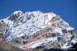
Everest from Lobuche
Lobuche is often classified as a Trekking peak due to the lack of technical difficulty and the relatively mild altitude; it is “only” 20,075ft/6119m . Teams like to use Lobuche for acclimatization because the summit is the same altitude as Camp 1 and it eliminates at least one trip through the dangerous Khumbu Icefall.
In 2011, I knew of at least two teams that used it in some form: International Mountain Guides (IMG) which was my team, and Himalayan Experience (Himex). Peak Freaks used Kala Patar for a similar purpose. In the IMG case, we made the 8 day trek from Lukla to Everest Base Camp proper at 17,500′, spent a few days then backtracked a full day to Lobuche. I understand that IMG will go directly to Lobuche in 2012 before arriving at EBC.
IMG and Himex had full Base Camps on opposite sides of Lobuche with IMG located at 15,740′. We stayed for one night before making a short two hour climb to our High Camp at 17,400′ We left that camp around 3:00 AM the following morning for our summit bid.
Lobuche West from Lobuche East
The climb was straightforward following the edge of a rocky slope but staying on snow slopes the majority of the route (.) The route steadily gained altitude and got a bit steep towards the summit. We crested onto a flat area of the summit ridge and stopped at the named Lobuche East aka the fore-summit of Lobuche. The views of Everest, Lhotse and Nutpse were outstanding from this rare vantage point.
There is another peak to Lobuche, West Summit which is substantially more difficult to reach as it is heavily corniced and requires rappelling down a steep notch then regaining altitude. Given we were acclimatizing, not peak bagging, we were pleased with the East.
Lobuche provides Everest climbers with a good shake down before heading into the Icefall. There are fixed lines, traveling at night, steep angles requiring ice axe, crampons, harness – the same as on Everest. That said, I am not convinced it is a good use of valuable energy with all that trekking back and forth.
Summit Statistics
The Grand Dame of all Everest statistics, Ms. Elizabeth Hawley reported a total of 526 summits in 2011. This brings the total number of people who have summited Mt. Everest to around 5630. It is estimated that 2,500 climbers, mostly Sherpas, have multiple summits meaning there have been about 3,130 individuals summits. As for 2011, Apa Sherpa has the most summits of Everest with his record 21st summit in 2011 and claimed it would be his last and sadly, there were 4 deaths in 2011, 3 on the south.
2011 was a good year for most teams. I want to applaud those commercial operators who are transparent with their summit statistics allowing prospective clients to evaluate their success rate. The best in class note their client numbers separately from their Sherpa numbers starting with their first Everest expedition. I think it is misleading to claim expedition summit success when it is only one or two out of many climbers; either guide, client or Sherpa.
Of note only Himex post their results for all their Everest climbs including clients, Sherpas and guides from the beginning in an easy to read table. For the others, I researched the 2011 numbers based on information in their public websites. Also of interest four companies: ���ϳԹ��� Consultants, Alpine Ascents, IMG and Himex represents 18% of the 5584 summits totaling combined 1042 summits.
Listed summits with success rate
2011: 17 of 28 clients/guides reached summit. 288 total summits (clients, Sherpas, guides) since 1991. 66% from 2006
2011: 8 of 12 clients summited, 3 of 4 guides and 15 of 13 Sherpas (2 with multiple summits). 338 total summits (clients, Sherpas, guides) since 1994, 0 – 96% success
Listed only summits from beginning, not % success rate (I found total 2011 clients embedded on their site)
2011: 6 of 6 clients, 2 guides, 14 Sherpas. 203 total summits (clients, Sherpas, guides) since 1990
2011: 7 of 7 clients, 2 guides, 6 Sherpas. 213 total summits (clients, Sherpas, guides) since 1992.
Listed summits in Blogs, not showing overall success rate over time (I found total 2011 clients embedded on their site):
2011: 3 of 13 clients, 1 of 2 guide, 7 Sherpas.
:2011: 1o of 10 clients, 2 guides, 9 Sherpas
: 2011: 5 of 5 clients, 3 guides, unknown number of Sherpas
The Everest Routes
There are over 18 named routes on Everest and a couple that are still unclimbed. The vast majority of climbers use two routes: the Southeast Ridge aka South Col route or the Northeast Ridge Standard aka North Col route. Both the traditional north and south routes have their pros and cons. Up until 2007, the trend was for more climbers to choose the north due to lower costs. But with the Chinese restricting permits over the past few years, the south side has retained the lead as the preferred route primarily due to commercial operators wanting to reduce uncertainty and to limit their risks.
In 2012, the Chinese have plus added more restrictions as to the use of Nepalese Sherpas and porters thus the cost is now about the same for a reputable commercial guided climb. That said, the north continues to attract climbers due to the history, less crowding and the appeal of Tibet. I know of north operators who have already sold out for 2012.
Traverses are becoming popular these days so let’s review some history. According to 8000ers.com, there have been 4 North to South and 8 South to North traverses and 2 west ridge to south col journeys. A traverse is when the climber starts at one base camp and ends at another.
With both sides once again attracting crowds for 2012, let’s take a brief look at their pros and cons:
South Col Route
| Pluses | Concerns |
| Beautiful trek to base camp in the Khumbu | Khumbu Icefall instability |
| Easy access to villages for pre-summit recovery | Crowds, especially on summit night |
| Helicopter rescue from base camp if necessary | Cornice Traverse exposure, SE Ridge Slabs |
| Slightly warmer sometimes with less winds | Slightly longer summit night |
Northeast Ridge Route
| Pluses | Concerns |
| Less crowds | Colder temps and harsher winds |
| Can drive to base camp | Camps at higher elevations |
| Easier climbing to mid-level camps | A bit more difficult with smooth or loose rocks |
| Slightly shorter summit night | No opportunity for helicopter rescue at any point |
An in-depth look at both sides of Everest
��

South Col Route
Mt. Everest was first summited by Sherpa Tenzing Norgay and New Zealander Edmond Hillary with a British expedition in 1953. They used the South Col route. At that time the route had only been attempted twice by Swiss teams in the spring and autumn of 1952. They reached 8500m well above the South Col. Of note, Norgay was with the Swiss thus giving him the experience he used on the British expedition. The Swiss returned in 1956 to make the second summit of Everest.
Here is a typical south side climb schedule showing average time and the distance from the previous camp plus a brief description of each section. More details can be found on the .
- Base camp: 17,500′/5334m
- Home away from home. Located on a moving glacier, tents can shift and platforms melt. The area is harsh but beautiful surrounded by Pumori and the Khumbu Icefall with warm mornings and afternoon snow squalls. With so many expedition tents, pathways and generators, it feels like a small village.
- C1: 19,500′/5943m – 4-6 hours, 1.62 miles
- Reaching C1, is the most dangerous part of a south climb since it crosses the Khumbu Icefall. The Icefall is 2,000′ of moving ice, sometimes as much as 3 feet a day. But it is the deep crevasses, towering ice seracs and avalanches off Everest’s West shoulder that creates the most danger.
- C2: 21,000′/6400m – 2-3 hours, 1.74 miles
- The trek from C1 to C2 crosses the Western CWM and can be laden with crevasse danger. But it is the extremely hot temperatures that takes a toll on climbers. Again avalanche danger exist from Everest’s West Shoulder that has dusted C1 in recent years.
- C3: 23,500′/7162m – 3-6 hours, 1.64 miles
- Climbing the Lhotse Face to C3 is often difficult since almost all climbers are feeling the effects of high altitude and are not yet using supplemental oxygen. The Lhotse Face is steep and the ice is hard. The route is fixed with rope. The angles can range from 20 to 45 degrees. It is a long climb to C3 but is required for acclimatization prior to a summit bid.
- Yellow Band – 3 hours
- The route to the South Col begins at C3 and across the Yellow Band. It starts steep but settles into a sustained grade as the altitude increases. Climbers are usually in their down suits and are using supplemental oxygen for the first time. The Yellow Band’s limestone rock itself is not difficult climbing but can be challenging given the altitude. Bottlenecks can occur on the Yellow Band.
- Geneva Spur – 2 hours
The route I took from the Balcony to the summit as seen from Lhotse on the same day I summited in 2011.
- This section can be a surprise for some climbers. The top of the Spur leading onto the South Col has some of the steepest climbing thus far. It is easier with a good layer of snow than on the loose rocks.
- South Col: 26,300′/8016m – 1 hour or less
- Welcome to the moon. This is a flat area covered with loose rock and surrounded by Everest to the north and Lhotse on the south. Generally, teams cluster tents together and anchor with nets or heavy rocks against the hurricane force winds. This is the staging area for the summit bids and the high point for Sherpas to ferry oxygen and gear for the summit bid.
- Balcony: 27,500′/8400m- 4 – 5 hours
- Officially now on Everest, climbers are using supplemental oxygen to climb the steep and sustained route up the Triangular Face. The route is fixed with rope and climbers create a long conga line of headlamps in the dark. The pace is maddeningly slow complete with periods of full stop while climbers ahead rest, consider the decision to turn back or continue to the balcony. It can be rock or snow depending on the year. Rock fall can be an deadly issue and some climbers now use helmets. They swap oxygen bottles at the Balcony while taking a short break for some food and water.
- South Summit : 28500′/8690m – 3 to 5 hours
- The climb from the Balcony to the South Summit is steep and continuous. While mostly on a beaten down boot path, it can be challenging near the South Summit with exposed slabs of smooth rock in low snow years. The views of Lhotse and the sun rising to the east is indescribable at this point. Climbers lose radio contact with EBC in this section.
- Hillary Step – 1 hour or less
- One of the most exposed section of a south side climb is crossing the cornice traverse between the south summit and the Hillary Step. But the route is fixed and wide enough that climbers rarely have issues. The Hillary Step is a short 40′ section of rock climbing, again fixed with rope, that creates a bottleneck on crowded summit nights. Usually there is an up and down climbing rope to keep people moving.
- Summit: 29,035′/8850m – 1 hour or less
- The last section from the Hillary Step to the summit is a moderate snow slope. While tired, climber’s adrenaline keep them going.
- Return to South Col: 4 -7 hours
- Care must be taken to avoid a misplaced step down climbing the Hillary Step, the Cornice Traverse or the slabs below the south summit. Also diligent monitoring of oxygen levels and supply is critical to make sure the oxygen lasts back to the South Col.
- Return to C2: 3 hours
- Usually climbers are quite tired but happy to be returning to the higher natural oxygen levels regardless of their summit performance. It can be very hot since most climbers are still in their down suits.
- Return to base camp: 4 hours
- Packs are heavy since everything they hauled up over the preceding month must be taken back down. It is now almost June so the temperatures are warmer making the snow mushy thus increasing the difficulty. But each step brings them closer to base camp comforts and on to their home and families.
For a more detailed description, please see the . Also, here is my animated map of climbing the South Col route:
https://youtube.com/watch?v=diQtFPbBFCw%3Frel%3D0

Northeast Ridge Route
The north side of Everest is steeped in history with multiple attempts throughout the 1920’s and 1930’s. The first attempt was by a British team in 1921. Mallory led a small team to be the first human to set foot on the mountains flanks by climbing up to the North Col (7003m). The second expedition, in 1922 reached 27,300′ before turning back, and was the first team to use supplemental oxygen. It was also on this expedition that the first deaths were reported when an avalanche killed seven Sherpas.
The 1924 British expedition with George Mallory and Andrew “Sandy” Irvine is most notable for the mystery of whether they summited or not. If they did summit, that would precede Tenzing and Hilary by 29 years. Mallory’s body was found in 1999 but there was no proof that he died going up or coming down.
A Chinese team made the first summit from Tibet on May 25, 1960. Nawang Gombu (Tibetan) and Chinese Chu Yin-Hau and Wang Fu-zhou, who is said to have climbed the Second Step in his sock feet, claimed the honor. In 1975, on a successful summit expedition, the Chinese installed the ladder on the Second Step.
Tibet was closed to foreigners from 1950 to 1980 preventing any further attempts until a Japanese team summited in 1980 via the Hornbein Couloir on the North Face.
The north side started to attract more climbers in the mid 1990s and today is almost as popular as the South side when the Chinese allow permits. In 2008 and 2009, obtaining a permit was difficult thus preventing many expeditions from attempting any route from Tibet.
Now let’s look at typical north side schedule showing average time from the previous camp plus a brief description of each section. More details can be found on the .
- Base camp: 17000′ – 5182m
- located on a gravel area near the Rongbuk Monastery, this is the end of the road. All vehicle assisted evacuations start here. There are no helicopter rescues or evacuations on the north side or for any mountain in Tibet.
- Interim camp: 20300′/6187m – 5 to 6 hours (first time)
- Used on the first trek to ABC during the acclimatization process, this is a spot where a few tents are placed. Usually this area is lightly snow covered or none at all.
- Advanced base camp: 21300′/6492m – 6 hours (first time)
- Many teams use ABC as their primary camp during the acclimatization period but it is quite high. This area can still be void of snow but offers a stunning view directly at the North Col. It is a harsh environment and a long walk back to the relative comfort of base camp or Tibetan villages.
- North Col or C1: 23,000′/7000m – 4 to 6 hours (first time)
- Leaving Camp 1, climbers reach the East Rongbuk Glacier and put on their crampons for the first time. After a short walk, they clip into the fixed line and perhaps cross a few ladders that are placed over deep glacier crevasses. The climb from ABC to the North Col steadily gains altitude with one steep section of 60 degrees that will feel vertical. Climbers may use their ascenders on the fixed rope. Rappelling or arm-wrap techniques are used to descend this steep section. Teams will spend several nights at the Col during the expedition.
- Camp 2: 24,750′/7500m – 5 hours
- Mostly a steep and snowy ridge climb that turns to rock. High winds are sometimes a problem making this a cold climb. Some teams use C2 as their highest camp for acclimatization purposes.
- Camp 3: 27,390′/8300m – 4 to 6 hours
- Teams place their camp 3 at several different spots on the ridge since it is steep, rocky and exposed. Now using supplemental oxygen, tents are perched on rock ledges and are often pummeled with strong winds. This is higher than the South Col in altitude and exposure to the weather. It is the launching spot for the summit bid with some teams spending the night or just a few hours.
- Yellow Band
- Leaving C3, climbers follow the fixed rope through a snow filled gully; part of the Yellow Band. From here, climbers take a small ramp and reach the northeast ridge proper.
- First Step: 27890′/8500m
- The first of three rock features. The route tends to cross to the right of the high point but some climbers may rate it as steep and challenging. This one requires good foot work and steady use of the fixed rope in the final gulley to the ridge.
- Mushroom Rock -28047′/8549m – 2 hours from C3
- A rock feature that spotters and climbers can use to measure their progress on summit night. Oxygen is swapped at this point. The route can be full of loose rock here adding to the difficulty with crampons. Climbers will use all their mountaineering skills.
- Second Step: 28140′/8577m – 1 hour or less
- This is the crux of the climb with the Chinese Ladder. Climbers must first ascend about 10′ of rock slab then climb the near vertical 30′ ladder. This section is very exposed with a 10,000′ vertical drop. It is more difficult to navigate on the decent since you cannot see your feet placement on the ladder rungs. This brief section is notorious for long delays thus increasing the chance of frostbite or AMS.
- Third Step: 28500′/8690m – 1 to 2 hours
- The easiest of the three steps but requires concentration to be safe.
- Summit Pyramid – 2 to 4 hours
- A steep snow slope, often windy and brutally cold, climbers feel very exposed at this point. Towards the top of the Pyramid, climbers are extremely exposed again as they navigate around a large outcropping and experience three more small rock steps on a ramp before the final ridge climb to the summit.
- Summit: 29,035′/8850m – 1 hour
- The final 500′ horizontal distance is along the ridge to the summit is quite exposed. Slopes angles range from 30 to 60 degrees.
- Return to Camp 3: – 7 -8 hours
- The down climb takes the identical route. Early summiters may experience delays at the 2nd Step with climbers going up or summiters having down climbing issues.
- Return to ABC: 3 hours
- Packs can be heavy since everything hauled up over the preceding month must be taken back down. It is now almost June so the temperatures are warmer making the snow mushy thus increasing the difficulty. But each step brings them closer to base camp comforts and on to their home and families.
For a more detailed description and route pictures, please see the . Also, here is my animated map of climbing the Northeast Ridge route:
https://www.youtube.com/embed/RIU4N8tY3zw?rel=0
The Deadly Side
To start any discussion on climbing deaths, it must be said that every death is devastating to family and friends and should never be taken lightly. I have helped bury climbing partners on high peaks and never wish that experience on anyone.
Sadly, mountaineering often receives mainstream media attention only when someone dies and especially on Everest. This was never more true than during the 1996 season that saw 8 people killed in a storm and then in 2006 when another 12 died while climbing.
According to Eberhard Jurgalski’s website, since 1922 the fatality rate was 5.4% but has dropped to around 4.4% since 1990 due to better gear, weather forecasting and more rescue resources available; ironically, due to more climbers on the mountain. As previously mentioned there were about 526 summits in 2011 with 4 deaths, unusually with 3 of those on the south side.
I wanted to examine the true statistics behind Everest in the past decade and looked to for some facts. Based on his tables, the north side fatality rate is more than 2:1 over the south with falls, altitude issues and exhaustion noted as the primary reasons. The difference is even more extreme when the deaths of 9 south side Sherpas are taken from the total, making the ratio of “member or client” climber deaths from north to south 8:1. Here is the summary update with 2011 statistics:
| Reason | North Ridge Route | South Col Route | Other Routes |
| Fall | 7 | 3 | 1 |
| Altitude | 9 | 3 | 1 |
| Exhaustion | 8 | 1 | 1 |
| Unknown | 7 | 1 | 1 |
| Avalanche | 1 | 3 | 2 |
| Crevasse | 0 | 4 | 0 |
| Exposure | 4 | 0 | 0 |
| Heart | 1 | 2 | 0 |
| �� | 37 | 17 | 6 |
That the north side death rate is higher is not a big surprise. The north is traditionally considered slightly more dangerous given the exposure to the cold and harsh winds plus the technical nature of the Steps and exposed rock on the summit ridge.
Due to lower costs, more independent climbers are on the north thus sometimes finding themselves alone in the event of a problem. Also, it seems that more climbers do not use supplemental oxygen on the north than on the south which also can accelerate altitude issues especially in the harshest of conditions.
However, there is no strong correlation between deaths of independent climbers vs climbers on commercial expeditions. Finally, with the exception of 2005 through 2007, the south has had significantly more climbers thus more rescue resources in the event of a problem. Traditionally, commercial operators have focused on the south thus fielding more Sherpas.
As far as nationalities, the Nepalese Sherpas suffer the most with 10 of the 57 deaths this decade almost all on the south side from falls, avalanches and crevasse accidents. 6 South Koren climbers have died but no other single nationality has more than 4 deaths in the past decade. As far as operators, no one operator stood out since the majority of the non-Sherpa deaths were of climbers on private national climbs, large shared permits or were climbing independently.
Summary
I am often asked which side is safer and my answer is pick your poison. The south has the Khumbu Icefall and the north has the Steps and weather. However these numbers clearly show the north takes a stronger toll. But the real story is the role and impact of the unsung heroes – the Sherpas.
In spite of the Icefall dangers, I think most operators will say the south side is safer and slightly easier. The sobering statistic backs up this advice – more climbers, by a 2:1 ratio, have died on the north than the south since 2000.
But the real answer is no one knows for certain what each season will bring. So train hard, get skills on low mountains and altitude experience on another 8000m mountain before Everest and go with a team you can count on in an emergency.
One day I will have to climb from the North to see for myself!
Climb On!
Alan
Arnette is a speaker, mountaineer and Alzheimer’s Advocate. He just completed his 7 Summits Climb for Alzheimer’s project to raise $1 million for Alzheimer’s research. You can read more on his .