11 Must-See, Must-Insta Places in New Zealand
Belgian photographer Johan Lolos spent a full year in New Zealand, posting pictures of his adventures on his Instagram account, , working for the Lake Wanaka tourism department, and establishing . Here are his top shots from his year in New Zealand.
Photo: The first time Lolos visited Lake Wanaka, he knew he wanted to live there. He emailed the tourism department of the small town on New Zealand’s South Island to ask if he could work as a photographer for the town for three months in exchange for housing. They agreed. After a few weeks, he requested to stay longer, telling them that he couldn’t imagine himself living anywhere else in New Zealand. The tourism department agreed, and he remained for another four months.
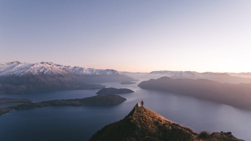
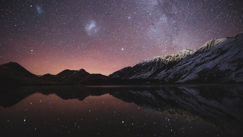
Roys Peak stands about 5,200 feet tall, overlooking Lake Wanaka. Located three miles—plus a three-hour hike—outside of town, the summit offers what Lolos calls the best view in the country. In mid-April 2015, Lolos camped on the peak with his friend Chris Burkard. The two were collaborating on a shoot for Lake Wanaka Tourism. Despite wind and cold temperatures at the mountain’s summit, the crew set up camp and photographed sunset and sunrise from the peak.
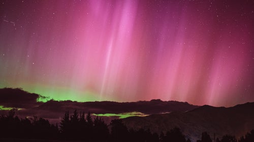
Here, Lolos captured the first time he ever saw an aurora. On St. Patrick’s Day, 2015, he drove a few miles outside of town to escape the city lights. There was such a large solar eruption that people in Europe could see it. “Wanaka is so remote that you don’t need to get far away to have clear skies,” says Lolos. “You could see all of the beams with your naked eye. Magic happened.”
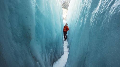
Franz Josef Glacier, and its neighboring Fox Glacier, are popular tourist destinations.They flow nearly to sea level, making them some of the easiest glaciers to reach via foot in the world. Franz Josef Glacier, pictured here, stretches nearly seven miles along New Zealand’s South Alps.
Lolos took guided tours of both glaciers in May, which is late autumn in New Zealand. He took a helicopter to the top of the Franz Josef Glacier to explore the bright blue caves and crevasses for a couple hours. “It was another world,” says Lolos. “We were like kids in a playground we’d never seen before.”
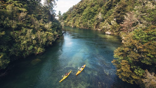
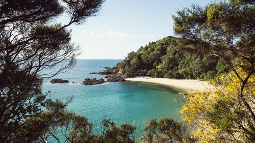
Abel Tasman National Park is home to one of New Zealand’s nine Great Walks. Each hike covers a famous trail, ranging in length from 20 to nearly 50 miles long. The Abel Tasman Track has a distance of just over 30 miles.
The first time he visited the national park, Lolos set off on a three-day kayak tour, on which he and his fellow paddlers explored seven or eight beaches. They spent two nights sleeping on two of them. For this shot, Lolos set off to hike part of the famous Abel Tasman Walk. He traveled an hour or two back to a spring bridge he had passed while kayaking and took a picture of paddlers from a different group.
Queenstown, “the adventure capital of the world,” as locals call it, is a common stop for travelers. Packed with adventure tourism companies, the town offers everything from ziplining and zorbs to skiing and rock climbing. Moke Lake is a small alpine lake and popular camping destination five miles outside of Queenstown.
Lolos and a friend drove from Queenstown to Moke Lake to photograph the aurora. At 23 degrees, what he remembered most about the trip was the cold. “There’s something about New Zealand that makes the cold so sharp,” says Lolos. “My fingers were completely frozen.”
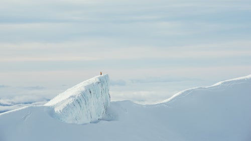
At over 9,000 feet tall, Mount Ruapehu is the highest point on the North Island and the largest active volcano in the country. It’s made up of three separate peaks, including Mount Ngauruhoe, known as Mount Doom in the Lord of the Rings. The mountain is home to two different ski resorts, Whakapapa and Turoa.
At sunrise, Lolos and a guide from Whakapapa Ski Area rode a snowcat up the mountain as far as it could go. Then, the two continued to hike two hours up to the crater, carrying their skis. At the top, the guide stood on the side of the crater while Lolos took this picture.
This hidden beach is on the North Island, north of Auckland. Most tourists drive straight to Cape Reinga, the northernmost point of the country, without pausing at Whale Bay. But Lolos asked his Instagram followers for beach recommendations, and the locals told him to visit this beach. Because it was in September, early spring in New Zealand, he had the area to himself. “You’d drive past it if you didn’t know what you were looking for,” says Lolos.

The second largest ski area in the region, Cardrona Alpine Resort, is located between Wanaka and Queenstown in the Southern Alps. It’s known for its family friendly slopes, but on a cloudless night it also offers a clear view of the stars. This was taken during what photographers refer to as the Milky Way season, which is when the Milky Way is visible—between March and October.
On one of his last nights living in Wanaka, Lolos spent the night in the chalet so that he could wake up early enough to capture the sunrise. When he saw how clear the sky was, he decided to shoot the stars as well. For this shot, he set his camera on a 30-second exposure and posed beside the chairlift. It became the photographer’s most popular shot on Instagram.
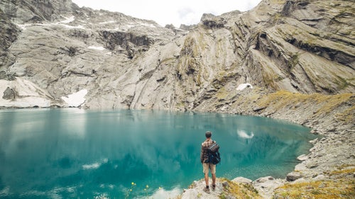
Crucible Lake is in Mount Aspiring National Park, the national park closest to Wanaka. Most of the park has been formed by glaciers, and it is the third largest park in the country. During cold months, icebergs float in Crucible Lake. But by February, when Lolos visited, they had already melted. A friend Lolos was with jumped into the water for a swim, still an icy 35 degrees. The group left by jet boat on the Matukituki River.
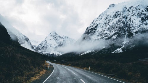
Milford Road leads directly into the iconic Fiordland National Park. On average, the rain falls in the park 200 days per year. Luckily, the journey into the park is most spectacular on wet, foggy days, when dozens of small waterfalls trickle down on either side of the road.
Lolos took this picture of his favorite road in the country on his last visit to the fiordlands. He’d already been twice in the summer, but he wanted to return in winter to see the snow-capped mountains and waterfalls. The road was slippery and weather reports cited a high risk of avalanche, so Lolos had to arrive before the road closed at 4 p.m. “When you’re on that two-hour drive from Te Anau, there are waterfalls on your right and your left, and you just want to pull over everywhere,” says Lolos.