
This is the tenth year of my blog at Semi-Rad.com, and since I started it, I’ve been fortunate to get to do some pretty wonderful adventures. Throughout this year, I’ll be writing about 12 of my favorite adventures, . This is the seventh in the series.
Around 8:30 P.M. on September 2, 2014, I stood in my friend Dan’s kitchen in Interlaken, Switzerland, slicing some crusty bread and smothering it with peanut butter and Nutella, when Dan came into the room.��
“You’re eating again?” he asked, incredulous. I replied something in the affirmative.
“You eat more than anyone I’ve ever met!” he said, sort of laughing, but not really joking. We had, in fact, just finished dinner a couple hours ago. But in my defense: We were getting up at 2 A.M. to start a hike at 3 A.M., covering 16 miles and 10,000 feet of elevation gain. I was not going to start out calorie deficient. Also, if you’ve eaten Nutella before, you might be aware that it’s fucking excellent.
I had known Dan and his wife, Janine, for a couple years, and we’d spent several weeks in each other’s company, in their house, on trails, glaciers, rock climbs, and next to each other in Swiss mountain huts. They shot photos, I wrote articles, and we had a great time hanging out while also getting work done. We knew a lot about each other. But I think this was the moment I realized that Dan and I had opposite attitudes about food and exercise. To him, food was merely fuel that enabled exercise. To me, exercise enabled eating food. I don’t hate exercise, and Dan wouldn’t say he hates food, but one of us gets a hell of a lot more excited talking about chile relleno burritos than the other one. Dan is an athlete who climbs 5.11c off the couch, runs uphill fast, runs downhill fast, skis uphill fast, and loves to crush mountain climbs on a road bike. I once ate five New York slices of pizza while running a marathon.��
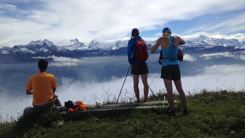
Just over five hours later, I pedaled one of Dan and Janine’s antique cruiser bikes through the quiet streets of Interlaken.��My then-girlfriend, Hilary, sat side-saddle across the rack on the back, and we followed Dan, pedaling with Janine seated in the same spot on his bike. We headed straight to the trail up to the Harder Kulm to access the west end of the Hardergrat, a sharp ridge of vegetated peaks rising above the deep blue lake, Brienzersee, several thousand feet below.��
Dan had sent me a photo of the ridge months before, saying something along the lines of “look at this amazing thing that’s in our backyard.” At that time there was no information about the on the internet, but I figured it would be yet another amazing adventure in which Dan basically dragged me behind him while I quietly took in some of the most beautiful scenery I’d seen in my life, while sweating four times as much as Dan did and struggling to talk and breathe at the same time. I would not be disappointed.��
The beta I had on the hike was basically this:
- 16 miles.
- 10,000 feet of elevation gain.
- No access to water once you’re up on the ridge.
- Must finish by 6:30 P.M. to catch the Rothorn train down from the ridge on the far east side, or walk a punishingly steep 5,400-plus-foot descent back to civilization, a hike that you will probably have to do by yourself, because Dan and Janine are nice but not necessarily psyched on sacrificing their knees on a downhill hike of several hours because you’re slow.
- Sure, you could take a train up to the top of the ridge to start the hike, but the train doesn’t start until later in the morning, and then all the good morning light is gone, so the photos will suck, and also you might not be able to make it across the ridge in time to catch the train at the other end, so we’re going to hike up to the ridge in the dark.
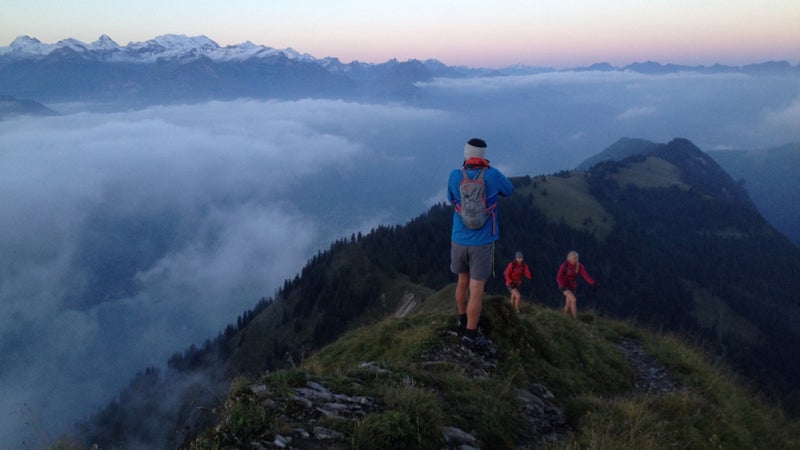
So, at 3 A.M., after a sizable breakfast and coffee in what is objectively still “the middle of the night” for most of humanity, we started hammering up the trail in the cool morning air. I took my shirt off, because I can manage to work up a good lather in almost any temperature, and what was the point of arriving on the top of the ridge in a soaked shirt? My headlamp bounced along the trail behind everyone as we cranked through switchbacks, climbing 2,400 feet in 2.1 miles, an effort that plenty of people (myself included) would refer to as “a good day.” A platform at the top of the climb provides a panoramic view of the snowy peaks of the Eiger, the Monch, and the Jungfrau, but it was still dark and clouds covered most of the sky, so we didn’t have a view. Nor did we have a coffee or pastries at the café at the top, because it didn’t open for several more hours.��
We walked on, following the narrow trail through trees, hoping to get to the point where the views opened up in time for sunrise. It had been the rainiest summer in 40 years in Switzerland, and we picked a day when the weather was supposed to be good. But low clouds swept around us on both sides of the ridge, obscuring the stars. The exercise was nice, but if we couldn’t see anything from the ridge, the hike was kind of pointless. Plus, if it rained, Dan and Janine had said the route was a bit dangerous.
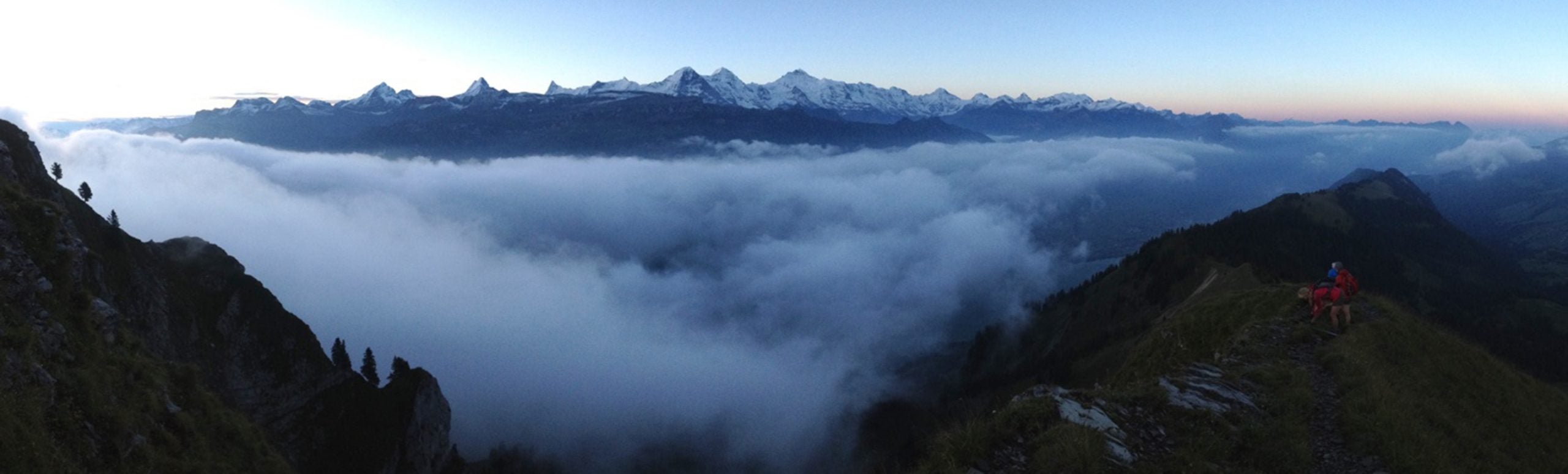
We made it to the top of the first of the real summits on the route, the Augstmatthorn, an hour after sunrise, and were above the clouds, staring south at the skyline of jagged, glaciated 4000-meter peaks ten miles away: the Finsteraarhorn, Schreckhorn, Eiger, Mönch, and Jungfrau.��
We’d climbed up 5,000 feet already in eight miles, and the ridge undulated between 6,100 and 7,400 feet, somehow packing another 5,000 feet of vertical gain in the remaining eight miles. As we descended from the peak, we ended up back in the clouds and had to make a decision: keep going and hope the visibility got better, or head down the trail on the north side of the Augstmatthorn and catch a bus. We found a flat spot to sit for a while and wait it out.
We had seen no one up until that point and would only see a couple people our entire long day on the ridge. This, of course, would change in the next few years, as Dan and Janine’s photos of the Hardergrat appeared in magazines and the route was discovered by Instagram-scouting travelers. The route up from the bus stop below the Augstmatthorn, a much friendlier hike with only 1,800 feet of elevation gain, makes for a much less committing photo op and drew more hikers over the years—by 2019, Dan and Janine’s friend and business partner Kim had taken to calling the Hardergrat “the Hipstergrat” as it became more popular. Eventually, YouTubers who did the whole hike started to refer to it using superlatives like “” and “.”
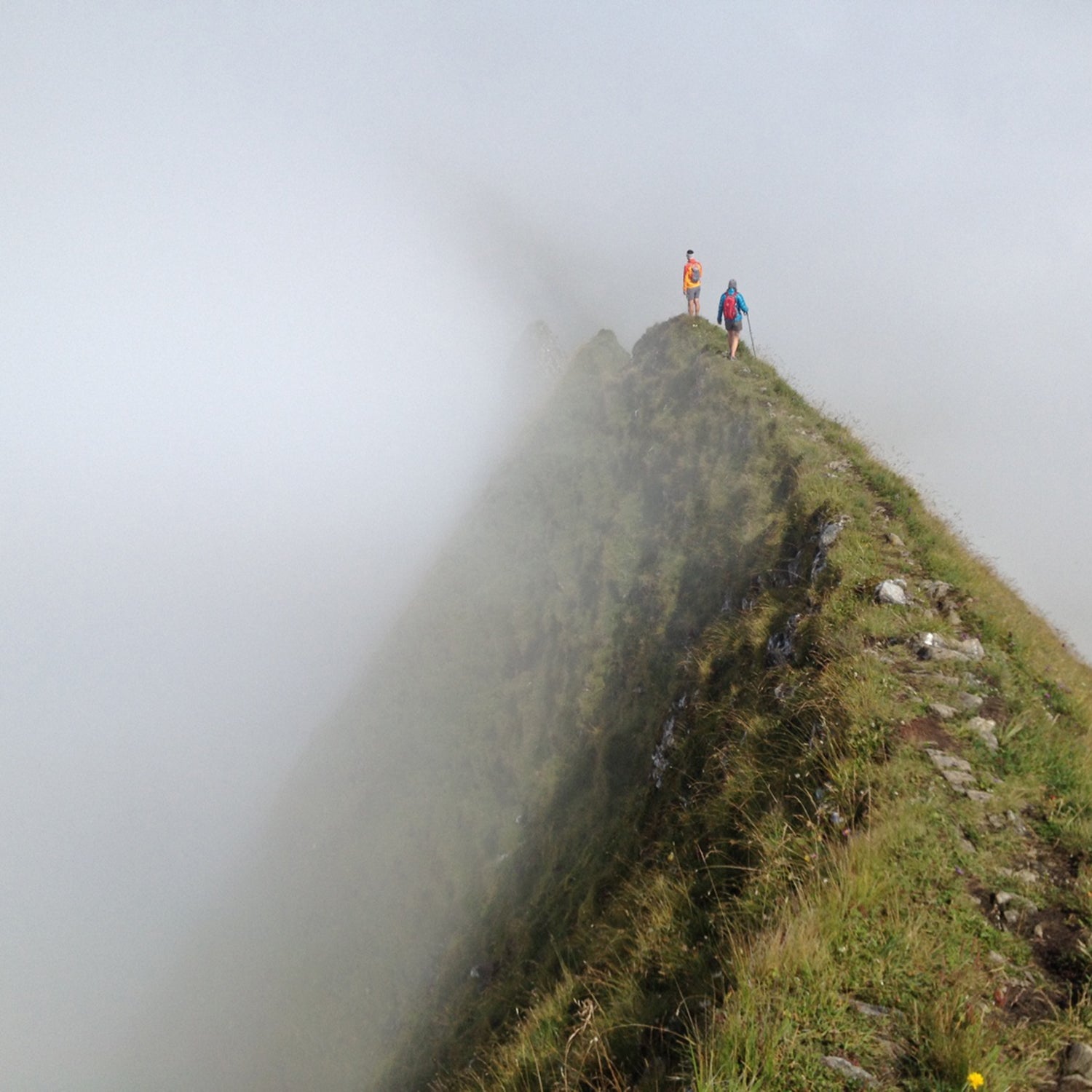
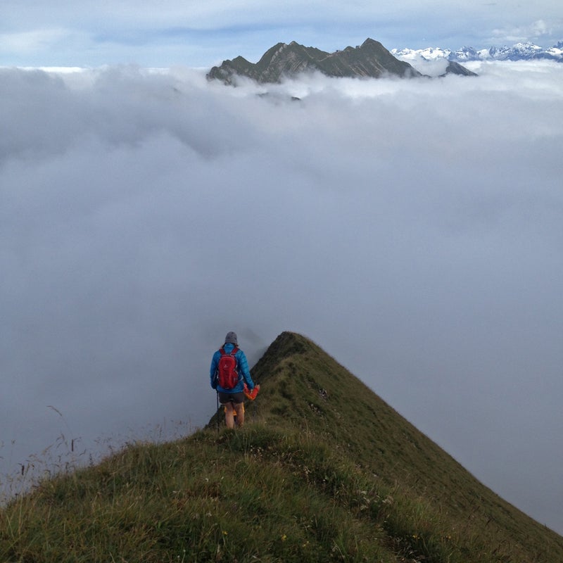
I sure don’t have enough experience to know if it’s the most dangerous hike in the world, but during the second half, I started to think I would have been a little more comfortable if I had brought an ice ax. The trail narrowed to a little more than a foot wide in spots, and there was no margin on either side—just a steep grassy slope that shot downward to Brienzersee, with nothing to stop a fall. It was a bit wet from recent rains, and I looked at my trekking poles thinking about how to self-arrest so I didn’t roll 5,000 feet down into the lake below. A few days earlier, Dan, Hilary, and I had cramponed up the snowy , and the previous evening, Dan had told us about seeing a climber fall off that ridge to his death in a crevasse a thousand feet below—a visual that made you think about catching a crampon point on your pants every single time you stepped.��
As I looked down the grassy sides of the knife-edge ridge on the Hardergrat, I thought about that climber on the Mönch, and thought, “Yeah, you know, an ice ax might not be overkill on the Hardergrat after a recent rain. Like today.” I found out later that the Hardergrat was, in fact, usually graded T5 on the Swiss Alpine Club’s rating system, a grade they usually used for mountaineering terrain where an ice ax is mandatory. Of course, we didn’t have ice axes, so we just had to be careful.��
The clouds finally parted, and Dan and Janine got a bit ahead of Hilary and I after the sun went overhead and blew out the good lighting, so we took our time, following the trail up and down the ridge, looking left and right toward the mountains, occasionally down at the valley and the lake below. The view changed incrementally every few dozen steps, and after about 50 iPhone photos, you kind of feel like you’ve captured it, but of course you haven’t. When you’re walking somewhere like that, you know it’s special, but you don’t know that years later you’ll feel like maybe you rushed it. Maybe you will make it back there again, maybe you won’t, and it for sure would be different, and even if it’s not different, you’ll be a little different, so the whole thing won’t be the same anyway. But damn, what a view.
We finally caught up to Dan and Janine near the end of the ridge as we approached the Brienzer Rothorn train station and ran into a herd of sheep grazing along both sides of the trail.��
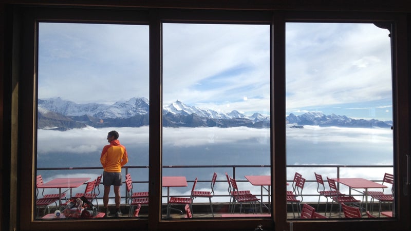
We arrived at the end of the route with enough time to mill around the café and patio while we waited for the train, with plenty of time for Dan to wash his hands in the restroom and for me to take down multiple ice cream things on sticks, which I definitely deserved.��
It’s bad form to lean over a photographer’s shoulder while they’re taking photos, because it’s not cool to poach their shot. Earlier in the day, as Dan and Janine were setting up with Hilary for a photo that would end up on the cover of Backpacker magazine a few months later, I had snapped a couple iPhone photos, even though I knew they were garbage compared to whatever Dan was capturing.��
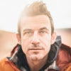
But at the end of the day, walking back from the restroom before the train arrived, I snapped one last photo of Dan looking south at the mountains, the 61st photo I’d taken that day. He doesn’t have a camera out, it’s at the end of a long, great day in the mountains, and he’s not moving, so I’m not desperately trying to keep up with him. He’s just standing there, looking around at the mountains that he loves so much, scanning the rugged horizon, dreaming up more adventures. It was a great view, which I realized enough to take a photo, but I was probably thinking about what I was going to eat when we got back down to town.
More information on hiking or running the Hardergrat route can be found .