Instead of gathering a widespread assortment of the week's best articles, videos, and photos, I've included the most thought-provoking and eye-opening articles on Sandy and her aftermath. Some are snapshots of people and places, others take a look at the science of the storm, and some take a look at the political effects of a storm that has caused tens of billions of dollars in damage and more than 150 deaths internationally. The articles begin with a blog posted on October 24.
Please share the best articles you've read about Sandy in the comments section.
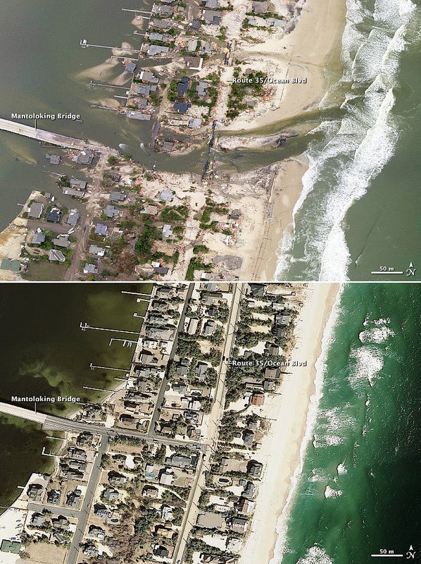
For the best longreads of the week, check out “Weekend Reading: Eyes Open.”
OCTOBER 24
“,” Capital Weather Gang
The deterministic runs from the various global models continue to
diverge, with some still showing a track out to sea (GFS and CMC) and
some showing a more northerly track into the northeast U.S. coast (ECMWF
and NOGAPS). It’s unclear yet which will verify, if any, but the
ensembles have been trending westward, with more members now showing a
very powerful cyclone (probably not completely tropical) slamming into
the mid-Atlantic and Northeast states.
The ominous forecast by last night’s ECMWF deterministic run places
an incredibly strong cyclone off the New Jersey coast on Monday
evening … with tropical storm to hurricane force winds covering every
state between Virginia and Maine (note that the wind speeds on this map
are at 5,000’ altitude, not the surface). A scenario such as this would
be devastating: a huge area with destructive winds, extensive inland
flooding, possibly heavy snow on the west side, and severe coastal
flooding and erosion.
OCTOBER 25, Rosenstiel School of Marine and Atmospheric Science Blog
While there is still inherent uncertainty in the forecast, especially
considering we are at least five days away from the phase, the majority of
the numerical guidance has now come into agreement that a phasing event
will occur precisely on the 21st anniversary of the Perfect Storm
somewhere between the mid-Atlantic states through Maine or potentially
the Nova Scotia region. Most of the models now indicate even stronger
jet dynamics will occur next week than occurred during for the Perfect
Storm, and that today’s storm could potentially deepen to well below 960mb or even below 950mb. The fact that the Gulf Stream is anomalously
warm for this time of year means that Sandy will weaken less as a
tropical system than it otherwise would have prior to the phase. Also, a
very strong blocking scenario (very negative NAO) has developed over
the north Atlantic means that the cyclone will be very slow moving, and
is likely to retrograde westward into the northeastern U.S. rather than
continue out to sea like most recurving extratropical cyclones do.
While it is too early to pin-down exact impacts from the system at this
time, it is likely that portions of the coastal Northeast will
experience a damaging storm surge, significant beach erosion, and a
prolonged severe wind and heavy rain event. Meanwhile, interior regions
of western Pennsylvania into Ohio may simultaneously be experiencing
heavy snowfall. Stay tuned!
OCTOBER 26
“,” Weather Underground
As it appears increasingly likely
that a ‘Frankenstorm’ may hit the U.S. coast somewhere between Delaware
and Maine between October 29 and November 1 I thought I would take a
look back and see what other late season storms of this nature and
magnitude have previously affected the region.
OCTOBER 27
“,” The Guardian via Grist
“[It] does worry me that the most powerful nation in the world …
denies what the rest of us can see very clearly [on climate change]. I
don’t know what you do about that. It’s easier to deny.”
Asked what was needed to wake people up, the veteran broadcaster famous for series such as and
said: “Disaster. It’s a terrible thing to say, isn’t it? Even disaster
doesn’t do it. There have been disasters in North America, with
hurricanes and floods, yet still people deny and say ‘oh, it has nothing
to do with climate change.’ It visibly has got [something] to do with
climate change.”
OCTOBER 28
“,” The New York Times
The streets of this seaside town, filled on Saturday night with
trick-or-treaters dressed as witches and pumpkins, emptied swiftly on
Sunday as the storm drove water up to the beach dunes that protect the
Boardwalk.
Halloween events were cancelled. Hotels were closed. Dolle’s, the town’s
source of saltwater taffy for 85 years, stayed open longer than any
other oceanfront shop. But the owner, Thomas Ibach, turned off the
lights at 4 p.m., a few hours before the state evacuation deadline. “You
just never know,” he said. He said a 1962 northeaster had wiped away
Dolle’s previous building.
OCTOBER 29
“,” New Yorker
A couple of weeks ago, Munich Re, one of the world’s largest reinsurance
firms, issued a study titled “Severe Weather in North America.”
According to the
that accompanied the report, “Nowhere in the world is the rising number
of natural catastrophes more evident than in North America.” The number
of what Munich Re refers to as “weather-related loss events,” and what
the rest of us would probably call weather-related disasters, has
quintupled over the last three decades. While many factors have
contributed to this trend, including an increase in the number of people
living in flood-prone areas, the report identified global warming as
one of the major culprits: “Climate change particularly affects
formation of heat-waves, droughts, intense precipitation events, and in
the long run most probably also tropical cyclone intensity.”