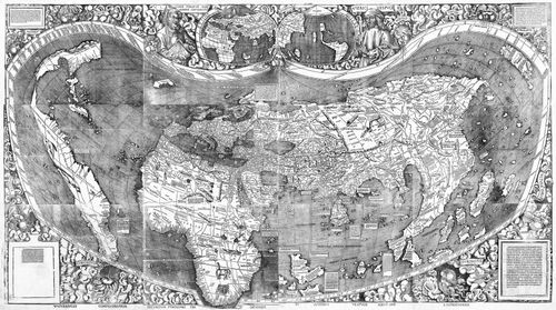
In 2003, the Library of Congress paid $10 million for a 500-year-old German map. Why the hefty price tag? The document is the only remaining copy of the 1507 Waldseemüller map, which contains the earliest known reference to the New World as America. Upon hearing of the sale, Toby Lester, a contributing editor at The Atlantic, started looking into the backstory of the document. The product of that research, The Fourth Part of the World: The Race to the Ends of the Earth, and the Epic Story of the Map That Gave America Its Name ($30, Free Press), is not simply the story of a map—rather, it's a macroscopic view of the history of exploration in the age of discovery. I spoke with Lester about the first picture of the earth from space and why today’s adventurers have nothing on medieval Franciscan monks. —Abe Streep
���ϳԹ���: What was your reaction on seeing the map for the first time?
Lester: By the time the Library of Congress put the map on display it was December, 2007, and I was almost finished writing the book. I'd already spent a lot of time with the map. I own a full-size facsimile and there’s a good digital version that the Library of Congress makes available. The digital version was great because I could literally zoom in. It was like flying over a very old, rich history. Still, there’s nothing like having face time with this 500-year-old picture of the world.
In a way it’s a technology story–this map was the original Google Earth.
There’s a big analogy there. The printing press was new at the time the map was made in the same way that the Internet is new now. And there’s a Wiki-element to the story. It wasn’t one person who managed to gather this information, which amounts to the first map that shows the world as we know it now. In a way the story that the book tells is how, collectively and over the course of hundreds of years, many people managed to piece together a picture of the world as a whole. But they weren’t trying. They had specific objectives that had to do with commerce or religion; they didn’t think of themselves as explorers in the way that we think of those people today.
The book features many compelling figures, from explorers like Marco Polo and Amerigo Vespucci to the German mapmaker Martin Waldseemüller, who created the 1507 map. Who’s your hero?
Waldseemüller is one of them, but he’s a careful, mild-mannered cartographer who doesn’t inspire a lot of heroic thoughts. I love these stories of early Franciscan missionaries, middle-aged, portly monks who crossed all of eastern Europe and parts of Russia, then headed into central Asia and China with a horse or two and some sandals and a robe. They braved the kinds of terrain that explorers today gear up for with the fanciest modern equipment. These guys just did it. But the book is full of heroes. Most people who come to this map want to seethe word America. But if you look at any part of themap you find a kaleidoscopic vision of not just the mapping of theworld but the exploration of the world.
The desire to fill in these gaps in the world map was fueled by stories of adventure that early explorers sent home. Often these were salacious, as with the Vespucci accounts of the New World. You write that “sex and horror sold” even then.
Absolutely. When National Geographic was the dominating travel magazine in this country you were seeing vaguely titillating but also curiously anthropological photos of women with naked breasts and people carrying things on their heads—stuff that seemed exotic to Americans. The exact same thing was going on with these early travelogues: There was talk of nakedness and cannibalism way before Columbus. There was talk of all these monstrous races that were supposed to inhabit the margins of the earth, people with faces in their chests and no heads and giant floppy ears that they could use as wings.
What’s next?
I'm going to write a book about Leonardo DaVinci’s Vitruvian man. While writing this book I came across a lot of early examples of medieval maps that correspond to that drawing. It seemed like it might be fun to do an unpacking of that image in the way that this book was an unpacking of the Waldseemüller map.
��