
As we started our three-day backpacking trip along the northern rim of Yosemite Valley, the trailhead was a zoo. And this was several years ago, even before the pandemic accelerated visitation to our national park system. Still, Yosemite National Park has always been a popular destination, notorious for crowds over the decades. But after we hiked just two hours on Upper Yosemite Falls Trail, the masses had thinned, and by the time we reached the rim above the valley, our group of six had the place to ourselves.
That’s the beauty of backpacking in our national parks; you can leave the traffic jams and crowded parking lots behind in just a few miles. With some planning and hard work, you can enjoy the country’s most iconic landscapes in relative solitude.
Here, I’ve detailed 10 of the best backpacking trails within our national parks. A few I’ve done myself, while others are still on my bucket list.��I’ve included something for everyone, from quick overnight jaunts to week-long treks that require serious legs and logistics.
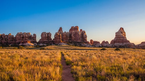
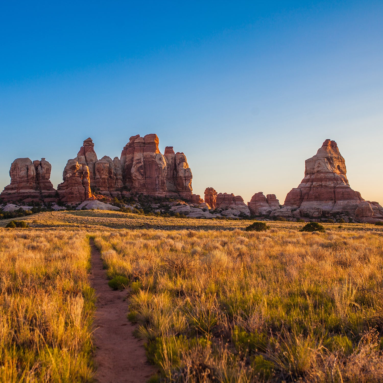
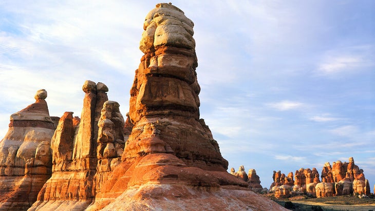
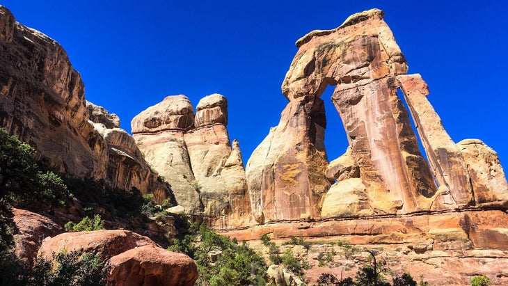
1. Chesler Park, Canyonlands National Park, Utah
Distance: 14 miles, overnight
Why It’s Great: This lollipop loop in the remote Needles District takes you through the sort of desert terrain, from slot canyons to arches,��that draws so many of us to the landscape of Canyonlands.
Hike It: The is moderate in length, but the terrain and lack of water and shade make it best suited for experienced backpackers. Starting at the Elephant Hill Trailhead, combine four trails (Elephant Canyon Trail, Druid Arch, Joint Trail, and Chesler Park), following cairns and well-signed trail junctions across slickrock and sandy washes. Most people hike it clockwise, and to get a broad view of the Needles District before descending into Elephant Canyon. There, you’ll squeeze through boulders and climb stairs through notches in vertical stone walls. At the end of Elephant Canyon Trail, you should tack on the four-mile out-and-back side trip to the 150-foot-tall Druid Arch for one of the best views in the Needles district. Carry on to Chesler Park proper, a broad circular valley with tall grasses hemmed in almost entirely by sandstone spires. Continue on the 1.5-mile Joint Trail, on the southern edge of Chesler Park—another highlight, as it has you scrambling along sandstone slopes, squeezing through boulders, and venturing into tall, narrow slot canyons.
Logistics: Elephant Hill Trailhead is accessible via two-wheel-drive vehicles and has pit toilets. Grab a up to four months before your trip ($36 per reservation, plus $5 per person, maximum seven people per permit). Reliable water sources are scarce, so plan to pack in all you need: the National Park Service and other government officials recommend at least one gallon per person, per day. Fall and spring are the best seasons to go, though winter has its charms if you have the right gear, including a zero-degree sleeping bag. Trekking in summer��heat is not recommended for safety reasons.
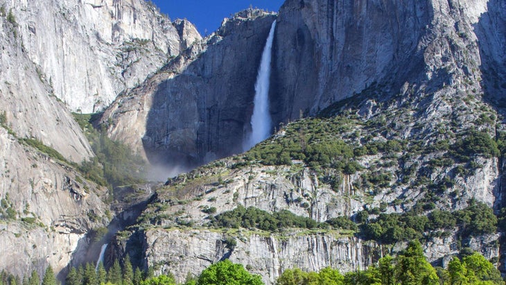
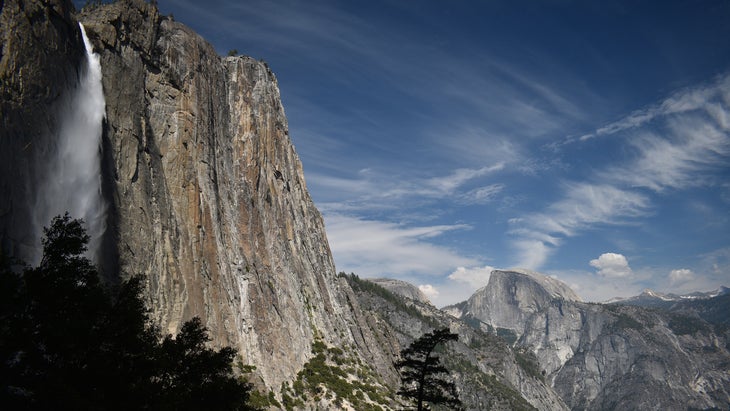
2. North Rim Loop, Yosemite National Park, California
Distance: 17 miles, two nights
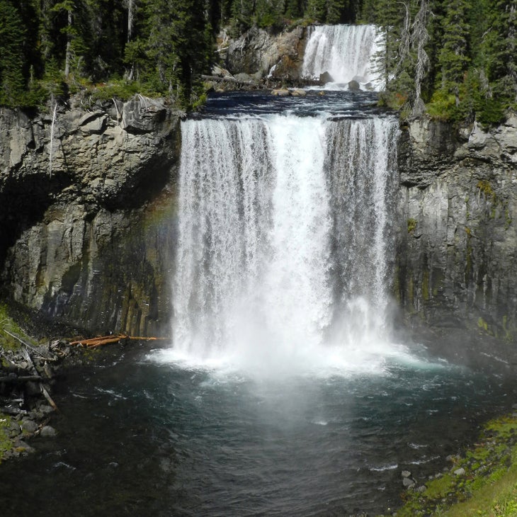
Why It’s Great: You’ll see Yosemite Valley—one of the best damn parks in the system, in my opinion—from a whole different perspective and enjoy one of the greatest camp spots��in the country.
Hike It: From Yosemite Falls Trailhead, the begins behind the historic climbers’ Camp 4, ascending Yosemite Falls Trail to the top of the tallest waterfall in North America. The trail ascends 2,700 feet, giving you a spectacular view, and the falls are so close you can feel the spray on your face.��
Yosemite’s backcountry has a dispersed camping policy, which means you can pitch a tent anywhere as long as it’s four miles from a trailhead and 100 feet from water or a trail. We found a quiet campsite tucked under tall pines next to Lahamite Creek, which holds ice-cold swimming holes perfect for summer visits. My group, which was full of climbers, spent hours bouldering near the water.
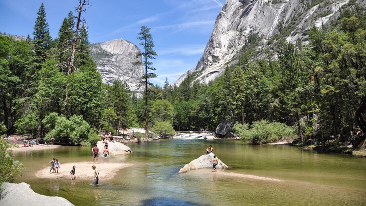
The highlight of day two is the view from North Dome, across Tenaya Canyon to Half Dome. Take the quick .5-mile side trip to Indian Arch, the only natural arch in Yosemite, before pitching a tent on Snow Creek Promontory, a granite dome directly across the valley from Half Dome and Mount Watkins. This is the finest place I’ve ever pitched a tent in my life, thanks to the view and exposure. Day three drops you off the north rim via the Snow Creek Trail, which loses 2,700 feet in nine miles�� into Tenaya Canyon, offering panoramas of the stunning monoliths of Half Dome, Quarter Dome, and Clouds Rest. You’ll pass by Mirror Lake in Tenaya Canyon with North Dome, Half Dome, and Mount Watkins in the background.
Logistics: A limited number of are available, designated by trailhead (apply for the Yosemite Falls Trailhead). Exactly 60 percent of the permits ($10 application fee, $5 per person, maximum 15 people per permit) are issued 24 weeks in advance, and 40 percent seven days in advance. This trip is good as soon as the snow melts (usually late April or early May). Do it in June or July if you want to see Yosemite Falls at its peak. You’ll find creeks along the route, so bring a filter You’ll find creeks along the route, so bring a filter (and a backup such as iodine tablets, or be ready to boil water).
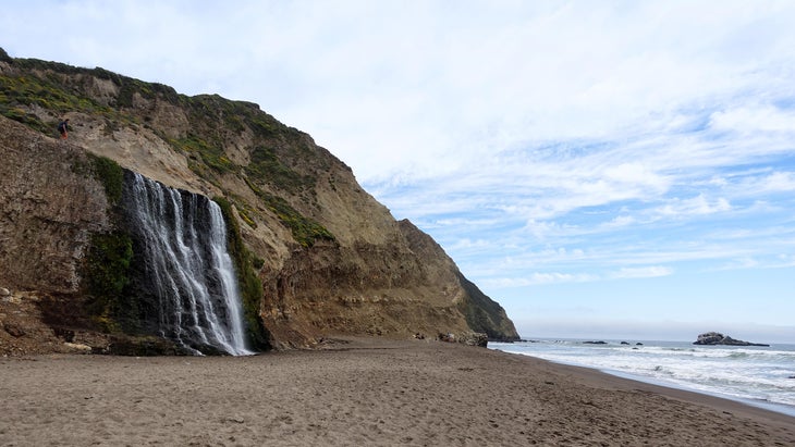
3. Coast Trail, Point Reyes National Seashore, California
Distance: 17 miles, overnight
Why It’s Great: This quick trip delivers you to secluded beaches and coastal bluffs in a wilderness area.
Hike It: The 17-mile-long makes the most of the remote landscape of Point Reyes National Park, where rocky headlands meet beaches and the raucous Pacific Ocean. The trail runs through the Phillip Burton Wilderness, reducing the number of people you’ll encounter (no vehicles�� allowed in wilderness). It meanders past a series of dramatic beaches that line Drake’s Bay; Wildcat Beach is the biggest, stretching for three miles. Sculptured Beach sits amid tall bluffs, with two creeks carving through the sand into the Pacific.
Coast Trail also dips inland several times, passing natural lakes and climbing to the top of rocky bluffs offering long-range views of the Pacific and its rugged coastline. You’ll have the chance to take a two-mile out-and-back side trip to Alamere Falls along Wildcat Beach, where Alamere Creek tumbles 40 feet over a cliff onto the sand. With multiple trails intersecting the entire Coast Trail, there are many such options for small loops and side hikes. To extend the trip, create a bigger loop incorporating some of the inland trails, some of which follow a ridgeline through a Douglas fir forest. You can even climb the 1,407-foot Mount Wittenburg, the highest point in Point Reyes National Seashore.
Logistics: Camping is only allowed at established campgrounds within Point Reyes, and the Coast Trail has two options. Coast Campground, towards the northern end of the trail, has 14 sites tucked into a valley and protected from the ocean wind, though the beach is an easy 200-yard walk from your tent ($30 per night, max six people per site). Wildcat Campground, towards the southern end, has five sites on a bluff above the beach ($30 per night, up to six people). Get a free up to three months in advance for either campground. There’s potable water at any backcountry campground within the national seashore.
Point Reyes is a treat any time of year, but keep an eye out for beach closures during winter to protect fragile wildlife. Summer is obviously your best bet if you want to go swimming. If you do this hike as a point to point, plan to leave shuttle vehicles at both trailheads.
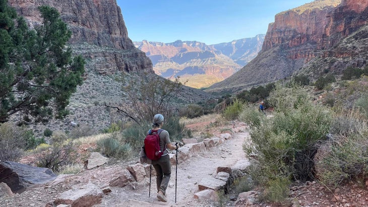
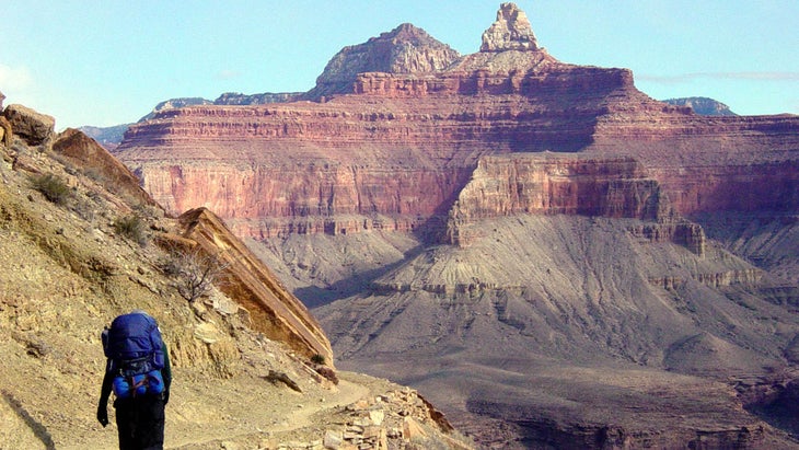
4. Rim to Rim, Grand Canyon National Park, Arizona
Distance: 24 miles, two to three days
Why It’s Great: This classic Grand Canyon adventure is as challenging as it is beautiful, showing backpackers what’s fondly known as the biggest ditch in America from a variety of perspectives most visitors never experience.
Hike It: The in the Grand Canyon might be the ultimate bucket-list backpacking trail. It’s possible to complete the Rim to Rim in a day, but this is a burly hike with 6,000 feet of elevation drop on the descent��and 4,500 feet of climbing on the ascent, so breaking it up with an overnight is kinder to your knees.
The most popular route follows the North Kaibab Trail from the North Rim down to the Colorado River and up to the South Rim via the Bright Angel Trail. The landscape is surprisingly lush as you begin at the North Kaibab Trailhead, with aspens and evergreens flanking the path. You quickly leave the foliage behind while switchbacking down along Redwall cliffs, reveling in the exposure and views deep into the interior.
If you want to break this up into a three-day trip, get a permit for Cottonwood Camp, roughly seven miles from the trailhead (see below for permit instructions). You’ll pass the hundred-year-old Phantom Ranch,��which has lodge rooms and a restaurant, just before reaching Bright Angel Campground. Even if you can’t score a reservation at Phantom Ranch, grab a meal from its restaurant, the Canteen, which serves a full sit-down breakfast and dinner (choose from stew or steak) and an old-school “hiker’s sack lunch” with salami and cheese.
After crossing the Colorado on Silver Bridge, a hiker-only overpass, you’ll climb out of the canyon on the Bright Angel Trail. The views are outstanding, with a literal oasis roughly halfway up, and the switchbacks towards the top of the climb will challenge even the most hardcore hiker. I tackled the Bright Angel as an out-and-back in my early 20s, and I still consider it one of my toughest day hikes. It was so easy going down to the river in the morning, and brutal��climbing back up.
Logistics: The top of Bright Angel Trail is closed until mid-April 2024 for waterline replacement work. Check on its before planning your hike. Snag a up to six months in advance for one of the 30 sites at Bright Angel Campground ($10 per permit, $15 per person each night, up to six people per site) through the lottery system via . As for timing, prime season falls between May and October. If you hike in the summer, start your days at sunrise to avoid peak temperatures. If you’re following the North Kaibab/Bright Angel route, you can find water and restrooms along the way. It’s easy to get a shuttle at the end of your hike to take you back to the North Rim. Or, really go for it: plan ahead with permits, water, gear, and food, and you can turn return via the North Kaibab trailhead for a 48-mile out and back.
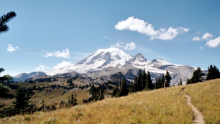
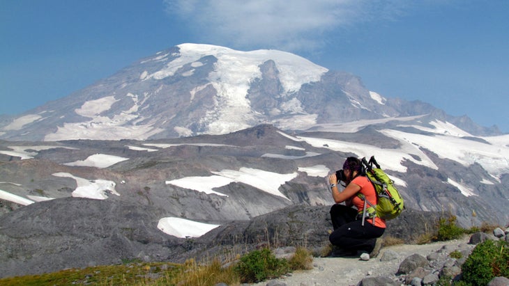
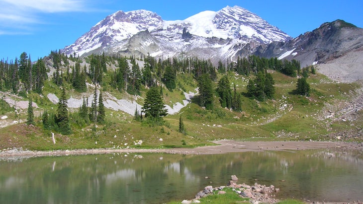
5. Wonderland Trail, Mount Rainier National Park, Washington
Distance: 93 miles, seven to 14 days
Why It’s Great: This massive loop is loaded with rainforests, high meadows full of wildflowers, and endless views of Mount Rainier, which has more glaciers than any other mountain in the lower 48.
Hike It: The circles Mount Rainier, climbing a total of 24,000 feet, with immensely varied terrain ranging from temperate rainforests to alpine tundra. The hike is located entirely in Mount Rainier National Park.
Most hikers tackle the route clockwise, starting from Longmire, Sunrise, and Mowich Lake. home to a ranger station and the seasonally open Longmire Wilderness Information Center, is the standard starting point. Longmire was once the site of the park’s original headquarters (now in Ashford). The compound, with an inn and museum, is a National Historic District.��
The Wonderland is hard, but you’ll experience the best Mount Rainer National Park has to offer, from remote alpine lakes to volcanic ridges, and from a bevy of wildflowers to the many perspectives of Mount Rainier. The climb to Panhandle Gap, a high-alpine pass with scree slopes and expansive views, is stunning, as is the glassy St. Andrews Lake, framed by Rainier in the background.
Logistics: Mid-summer (June and July) is the best time to go: the snow has melted and the wildflowers are popping. There are 18 developed campsites along the trail. are released during an early-access lottery beginning in February and ending in March (dates TBA, $26 per permit for up to 13 days (the 14 days above is a conservative estimate, and in that case, the person would walk out on the last day rather than need another night)��and five people per site). The remaining permits are available starting April 25. You can beforehand at certain campgrounds and ranger stations (you can mail food or drop if off in a plastic container such as a five-gallon bucket) to lighten your load. along the trail to lighten your load.
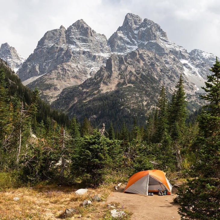
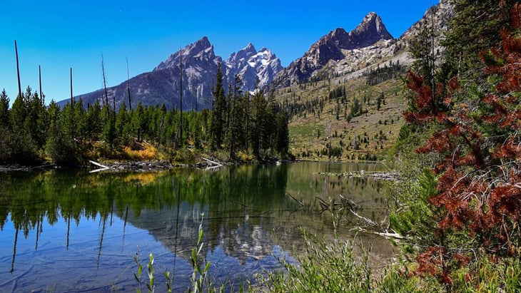
6. Teton Crest Trail, Grand Teton National Park, Wyoming
Distance: 40 miles, three to five days
Why It’s Great: This trail offers a bounty of wildlife spotting, views of glaciated peaks, and travel on high-alpine passes in the southern portion of Grand Teton National Park.
Hike It: The Teton Crest Trail officially starts outside of the park, at Phillips Pass in Jedediah Smith Wilderness, and ends at String Lake, after gaining more than 9,000 feet of elevation along the way. The majority of that gain comes during a couple of gradual ascents, which make this trek ��surprisingly user-friendly.
Many backpackers take the Aerial Tram from Teton Village to the top of Rendezvous Mountain, to cut a few miles and 2,400 vertical feet off the itinerary. No shame in that game. Also, the chances of seeing elk and moose on this hike are high, especially around the backcountry lakes. The 2,800-foot climb up to Paintbrush Divide, toward the end of the hike if you’re headed north, is the toughest. The views into the hearts of various canyons and from above-treeline passes will entertain you the whole way, and you’ll likely only see a few other backpackers.
Logistics: Snag a ��early ($20 per permit, $7 a night per person, max six people per site). The park released them on January 10 at 8 A.M. MST, and they go fast. Fortunately, two-thirds of the permits are withheld for walk-up reservations one night in advance of your trip during hiking season (May through October). Hit this one in late June through August for the warmest conditions.
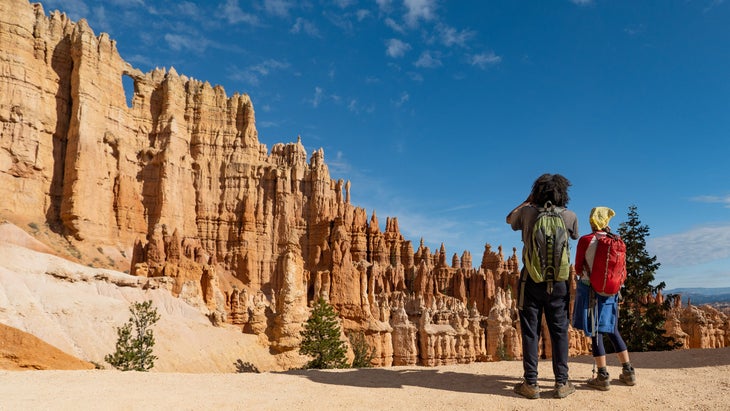
7. Under the Rim Trail, Bryce Canyon National Park, Utah
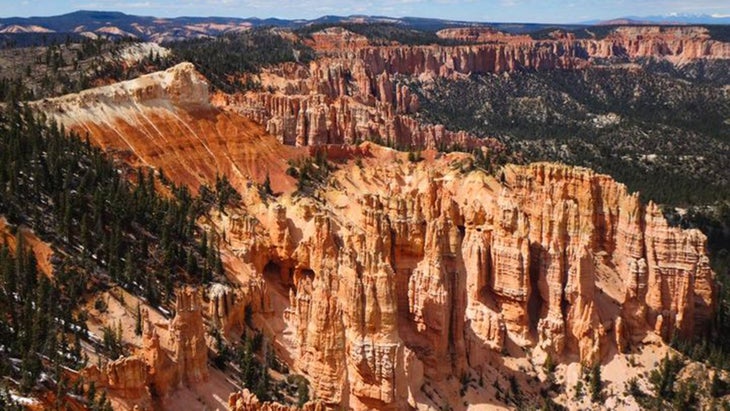
Distance: 23 miles, three days
Why It’s Great: Everyone sees Bryce from the top of the canyon, but this trail drops well below the rim, providing solitude and the opportunity to see it��from the bottom.
Hike It: Bryce Canyon��is known for its desert landscape and hoodoos, most accessible by easy trails and overlooks. Still, step into the backcountry on the trail and you’ll see a whole new aspect, because there are trees and creeks in the desert. Honestly.
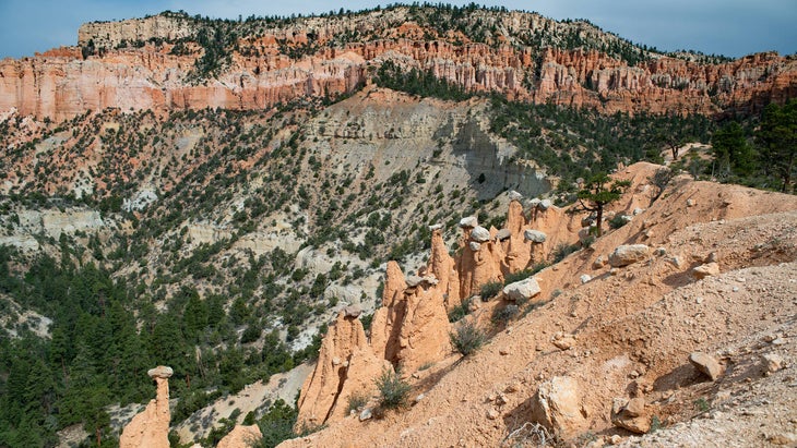
Hikers will find plenty of Bryce’s signature rock spires on this route, as they descend deep into the eastern edge of the plateau, where meadows and forests of thriving ponderosa pine and aspen trees thrive. Views of towering orange cliffs and vistas extend into the Grand Staircase. And don’t worry: an area dubbed “Hat Shop” is loaded with Bryce’s famous hoodoos, or sandstone columns left by weather and erosion, many capped by boulders of more resistant rock. The trail gains 5,500 feet in 23 miles, so it’s not a leg burner. Most people hike the Under the Rim heading north from Rainbow Point to Bryce Point. Aim to camp at Natural Bridge and Yellow Creek if you’re breaking this up into three days.
Logistics: Get a ��for campsites up to three months in advance ($10 per permit, $5 per person,����maximum six people per site). Water sources are unreliable, so bring your own (again, one gallon per person, per day).
Bryce has a free park shuttle, but unfortunately it doesn’t run to Rainbow Point, so you’ll need two cars (or can hire a private shuttle from from $15 per person). To preserve the fragile ecosystem, camp only in one of the six designated campsites along this trail. June to September promise the most pleasant weather.
8. Bechler River Traverse, Yellowstone National Park, Wyoming
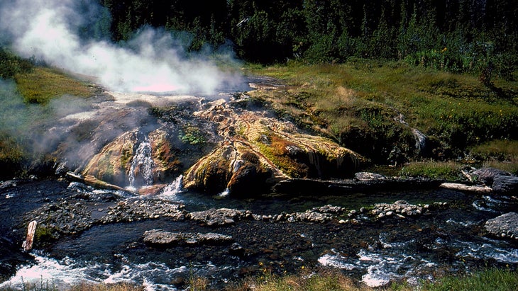
Distance: 35 miles, four to five days
Why It’s Great: This multi-day backpacking trip��has everything you want out of your Yellowstone National Park��visit: geothermal features, waterfalls, wildlife, meadows…and none of the crowds.
Hike It: Start near Old Faithful and pass the Lone Star Geyser before dipping into the backcountry and leaving the hordes behind. You drop into Bechler Canyon, where the river carves a dramatic gorge through the southwestern corner of Yellowstone, creating a series of waterfalls. Colonnade Falls has to be the best, dropping more than 100 feet in two parts. You’ll pass a number of geothermals, especially in Shoshone Geyser Basin, including “Mr. Bubbles,” a hot spring on the edge of the Bechler River where you can soak safely. Further, you reach an awesome view of the Teton skyline across the grasses and streams of Bechler Meadows. This route also has a high success rate for wildlife sightings, such as of bison and potentially even wolves. Optional side hikes to destinations like the three-mile out-and-back to Shoshone Lake with its excellent trout fishing beg you to tack on extra days.
Logistics: are first allocated through an Early Access Lottery��on March 1 at 8 A.M. MST ($10 reservation fee, $5 per person per night). A general-permit sale starts April 26 at 8 A.M. MST. You can also score walk-up permits two days in advance of a trip. There are a few river crossings, so it’s best to wait until August or early September, when the temperature is warm and the snowmelt has settled. Mosquitos can be bad in July, too. Carry bear spray, as this is grizzly country, and know how to use it. Use the food-storage boxes at each designated campsite and never, ever take any food into your tent with you.
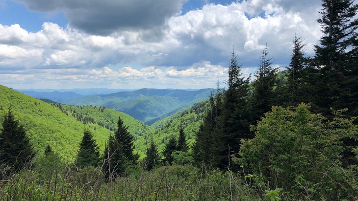
9. Appalachian Trail Section in Great Smoky Mountains National Park, Tennessee and North Carolina
Distance: 72 miles, seven days or more
Why It’s Great: This is a gorgeous stretch of the most famous footpath in America. You can spend the night in trail shelters, which helps save weight, while the forest changes from dense hardwoods at the lower elevations to sparse evergreens on the ridgelines. You’ll also cross some of the tallest peaks east of the Rockies, such as 6,593-foot Mount LeConte.
Hike It: The Appalachian Trailtravels north through the length of Great Smoky Mountains National Park, following the North Carolina/Tennessee border from Lake Fontana to Davenport Gap. The trip starts with a big climb that culminates at Shuckstack Fire Tower, then undulates along the roof of the Southern Appalachians for 20,000 feet of elevation gain. I’ve hiked most of the AT in the Smokies as a series of day hikes, and the terrain is surreal.��You’ll also encounter few people throughout most of the trail, as most hikers in GSMNP choose short trails close to parking.
At the 6,593-foot Mount LeConte, a concrete lookout platform offers views of the park all the way back down to Lake Fontana. Such spectacular moments abound, from the 360-degree vistas from the outcropping Rocky Top to the picture-perfect stone lookout tower on Mount Cammerer. Spending your nights in the AT’s signature three-sided trail shelters is just fun.
Logistics: You need a to stay in or around the AT shelters ($8 per night per person, max eight people per site). Get them up to 30 days in advance. Water is plentiful throughout this stretch, but bring a filter. You can hike the AT year round, although winter will be icy and snowy and requires a whole gear re-think. Summer is delightful, as you’ll be above 5,000 feet for the most part, and fall offers incredible views of foliage.
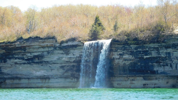
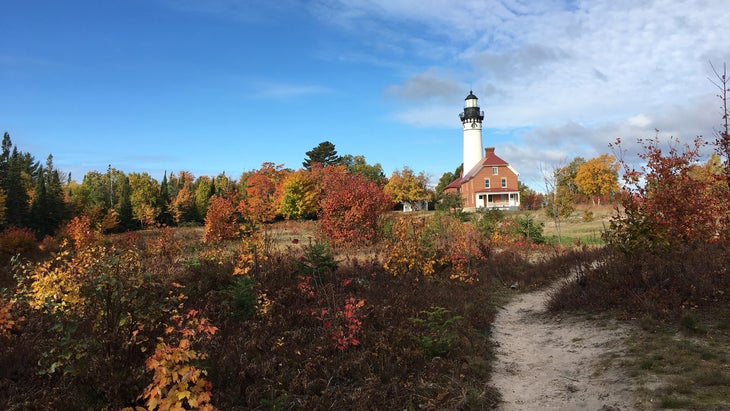
10. North Country National Scenic Trail, Pictured Rocks National Lakeshore, Michigan
Distance: 42 miles, four days
Why It’s Great: This slice of the 4,800-mile-long North Country National Scenic Trail��traces the edge of Pictured Rocks National Lakeshore, Michigan, and is packed with dunes, bluffs, beaches, and waterfalls as you walk along the rim of the biggest, deepest lake in North America.
Hike It: The North Country National Scenic Trail runs east to west for 4,800 miles, crossing eight states. A particularly beautiful portion joins the through Pictured Rocks National Lakeshore, following the edge of Lake Superior, which at 2,900 cubic miles is so large it could be an inland sea. Much of the trail travels through the forest above the water, though hikers occasionally dip down to the water, where rocky beaches meet tumultuous waves. You’ll pass the Au Sable Light Station, cross over dunes, and spend miles atop sandstone cliffs that rise 200 feet above the waves. The waterfalls along the way include Spray Falls, which drops directly into Superior.
Logistics: Get a starting on Jan. 1 at 10 A.M. EST ($15 reservation fee, $5 per person per night, maximum six people per site). May and October can be snowy and cold, so aim for late summer after the black flies have died down (they’re usually active in June). You’ll find water sources throughout, but bring a filter.
That’s it, coast to coast: brilliant backpacking trails in our national parks, so stop dreaming and start planning. Snag a permit, grab your pack, lace up your boots, and go.
Graham Averill is ���ϳԹ��� magazine’s national parks columnist. He thinks day hikes are great, overnights are better, and multiday adventures are best. His favorite backpacking trip ever in a national park? North Rim, hands down.

For more by Graham Averill, see:
To read about historic lodges and architecture in our national parks, see: