Soon it'll be mud season–time to escape to drier ground. And there's no better remedy to the tail end of winter than dropping a thousand feet into the canyons of southern Utah.
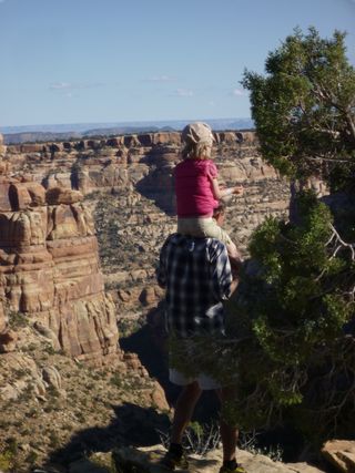
My husband, Andy, and I have traveled with our girls, ages 2 and 5, all over southeastern Utah. By far, our favorite spot is, just southwest of Blanding, Utah. This is the spot where Ed Abbey set parts of his infamous book, The Monkey Wrench Gang. One visit to Cedar Mesa, and it’s easy to see why. The expansive landscape, with its rolling mesas of slick rock and maze of canyons, is the perfect place to stage an escape, whether you are a rag-tag group of eco-warriors or a family looking for a weekend reprieve.
Cedar Mesa has excellent, easy-to-find camping, there are great ruins, and trails for every skill level. One of our favorite hikes is the Fire House Ruins hike in South Mule Canyon. Photographers flock to this spot in the early morning to see the ruins glow. When our kids tire from hiking, Andy and I take turns trail running here, often looping out of North Fork of Mule Canyon and returning down the South Fork of the canyon. Whoever isn’t running takes the kids to one of the creeks close by, where they can have fun becoming mud monsters and building mud pots out of Utah’s fabulous red dirt.
When to go: Shoulder seasons are best: March- May; September- Early November. Average temperatures hover around 70°F.
Directions: Cedar Mesa is located southwest of Blanding, in the southeast corner of the state. Head south out of Blanding on Highway 191. Go 3.9 miles and turn west on Highway 95. Drive through the Comb Ridge road cut, and you'll see Cedar Mesa stretching out in front of you for miles of remote canyon exploration.
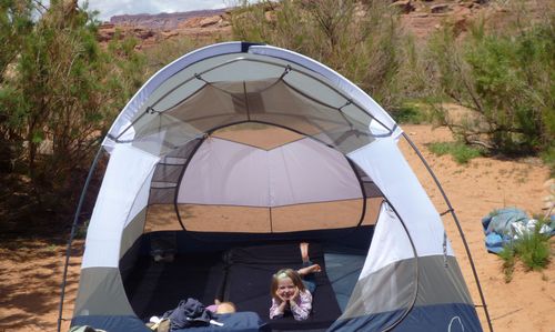
Where to Camp: Follow the Comb Wash Road (235) to developed campsites. For more private camping, consider exploring road 205 (directly across Highway 95 from road 235) and looking around the mouth of Arch Canyon. There is also primitive camping close to the Fire House Ruins. If you're planning on hiking Natural Bridges, there is a 13-site developed campground available in the park. Camping is first-come, first-serve. Bring water for all camping.
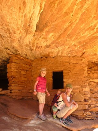
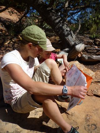
What to do: There are hundreds of great ruins and canyons to explore here. In addition to the Fire House Ruins, we also love hiking to the tower ruins at the surface of Mule Canyon and at Natural Bridges National Monument. The loop connecting Bullet Canyon to Kane Gulch is a great three-four day introductory backpacking trip. (We’ve taken middle school age kids down there on school trips.) Fish and Owl is a good intermediate three-four day backpacking loop (some slick rock scrambling required on the way out). Take careful note of road conditions. The dirt roads in this area are not always well maintained and can become impassable after heavy rain. Four-wheel drive is recommended.
Hiking:
(South Mule Canyon): Easy 1.25 mile hike to the ruins. Exploring further up the canyon is a treat if you have time and energy. To get to the trailhead,
drive east on Highway 95 for about 1/2 mile to San Juan County Road 263 (Arch Canyon), and then north on that road for about a third of a mile to the pull-off along the side of the road. There is a $2/person per day hike fee.
: Easy ½ mile hike to the ruins. The ruins are perched at the edge of canyon— the perfect vantage point for the ancients to view their enemies, but exciting if you have little ones. Watch the edge! To get to the trailhead from the Fire House Ruins, travel east for 0.8 miles on Highway 95 to mile marker 102.2. Turn south on the dirt road and through the gate. If you have a high clearance vehicle and are short on time, you can drive a little closer to the ruins. We generally park here and hike the dirt road south for a half mile to the ruins located at the Tower Trailhead.
: The National Monument is filled with beautiful moderate hikes. The loops are all less than 1.5 miles. The shortest and easiest (.5 mile round-trip) is trail to Owachomo. Some of the hikes have ladders and require short scrambles. Natural Bridges National Monument is 35 miles west of Blanding on Highway 95. Turn right (north) on Highway 275 and follow it to the end. (About 45 minute drive time from Blanding.)
Backpacking
: This moderately difficult trail connecting Bullet Canyon to Kane Gulch has fabulous ruins and side canyons to explore. The loop is 22.8 miles and takes 3-4 days to complete. There is a $5/ person per 7-day trip fee. To reach the trailhead, drive 7 miles south of the Kane Gulch Ranger Station on State Highway 261 and turn right. This dirt road (County Road 251) takes you 1.5 miles to the trailhead.
: Another great and slightly more challenging 16-mile loop filled with ruins and fabulous views. There is a $5/ person per 7-day trip fee. To reach the trailhead, travel one mile south of Kane Gulch Ranger Station on Route 261. Turn east and drive approximately five miles on a dirt road to a drill hole, which is the parking area. Avoid this road in heavy rains or snow.
For more suggestions of hikes and backcountry permits, stop by , located on Utah Route 261, about four miles south of Utah Route 95 from Blanding. Michael Kelsey’s Non-Technical Guide to Hiking the Colorado Plateau is another great resource for exploring this area more extensively.
—Guest Blogger