


Restoring Montana’s Clark Fork River
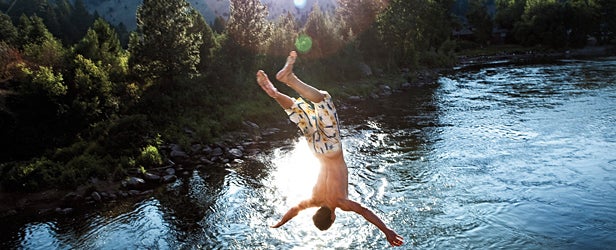
ONE HOT DAY last July, a group of us drove to the town of Turah, Montana—two bars, one camp-supply store—and dropped two rafts into the loveliest Superfund site in America, the Clark Fork River. My companions were four scientists and a schoolteacher, and we were there to see the remnants of a dirtier era.
We floated until we passed a kid flying a kite onshore. Soon after, I heard a low growling. The rumble amplified until we rounded a bend and came upon the source of the noise—trucks—at the confluence of the Clark Fork and Blackfoot rivers. Where the Milltown dam had sat for the past century, plugging up the Clark Fork and serving as a catchment for tailings from an upstream copper mine, the riverbed was now dry. Dump trucks and backhoes crawled between blackened tree stumps, removing arsenic-laden sludge. What the river ran through here, at the point where it met the Blackfoot—the waterway that famously haunted Norman Maclean—was a concrete gutter, a diversion skirting the old dam site.
Our party was the second group to float to the dam site since the removal. (Montana governor Brian Schweitzer had floated through to the cheers of a waiting crowd one week earlier.) Still, we had the privilege of seeing a river in a state of remedial distress. I turned to one of my rafting partners, Matt Daniels, a hydraulic engineer hired by the state of Montana to rebuild the Clark Fork’s natural channel through the old dam site, and asked what his plan was. He shrugged.
“The goal is to rebuild a natural floodplain,” he said. “We have an idea of where the river used to flow, but it’s going to go where it wants to go.”
THESE DAYS, Montana’s fastest-growing industry is restoration, and ground zero for the boom is the Clark Fork. The cleanup of the 120-mile upper river will create some 3,500 jobs over the next decade. Much of the money funding the new “restoration economy”—Schweitzer’s favorite buzz phrase—comes from the energy company ARCO, which has owned the mine responsible for the Clark Fork’s degradation since 1977.
To call this comeback unexpected would be like calling the 2004 Red Sox World Series victory a nice little turnaround. For most of the 20th century, the state’s economic policy went like this: Ranch, log, and mine—quickly. Those industries created jobs and forged a defiant spirit in many Montanans, but recently the zeitgeist has shifted.
“Part of it was miners and loggers saying, We need extraction, but we also need to value the environment,” says Jim Kuipers, a former mining engineer who now advises government officials cleaning up the Clark Fork. “But one of the biggest things was that the Superfund designation brought jobs.”
The Clark Fork flows 320 miles through the western part of the state and into Lake Pend Oreille, Idaho. The river’s tributaries include the Flathead, the Bitterroot, Rock Creek, and the Blackfoot— geologic stars of Montana’s $240 million-per-year angling industry—so the fact that the Clark Fork is the most polluted waterway in the state is ironic. The river is hemmed in by train tracks on one side and I-90 on the other, hard lines of transportation that have cut off the floodplain and shortened the river by 13 miles over the past century. The headwaters? Silver Bow Creek, a stream in Butte that’s been catching runoff contaminated by the tailings of a massive copper mine since the 1880s.
In 1905, the copper baron William A. Clark began building the Milltown Dam at the town of Bonner, and over the next century the dam was transferred among energy companies. By 2000, it produced one-tenth of 1 percent of the state’s power while employing precisely two dam operators. Milltown did, however, function as an effective holding tank for Butte’s mine tailings. The upper river has been designated a Superfund site—a toxic-waste source the federal government helps clean—since the early eighties, when Bonner residents discovered arsenic in their drinking water.
Since obtaining the Superfund designation, Montana has received some $300 million in federal money and won some $200 million in lawsuits from ARCO, which was bought out by the much-maligned oil giant BP in 2000. Now, after a couple of decades during which grassroots organizations pushed for dam removal, that money is putting people to work. Timber companies bid for contracts to rebuild riverbanks; engineers like Daniels redesign river channels; former miners dredge Silver Bow Creek.
The work won’t dry up anytime soon. The removal of the dam was crucial, but the Clark Fork’s headwaters still need cleaning, and conservationists point out the necessity of rewatering the river’s smaller, lesser-known tributaries, which have long been siphoned off for agriculture.
“There’s simply more business in restoration,” says Karen Knudsen, executive director of the local Clark Fork Coalition, a nonprofit that led the push for dam removal. “We want this to be a global example of how a damaged watershed can be fixed.”
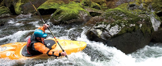
DURING THE SAME TRIP to Montana, I also floated the Blackfoot. This was partly out of professional interest and partly because it was the peak of fishing season. Ponderosas lined the banks, trout slapped the surface, a flotilla of rafts full of undergrads passed.
Today, the Blackfoot is about as pristine a river as you’ll find in the lower 48, but not so long ago it was a mess, too. The Blackfoot fishery nearly crashed in the seventies and eighties, courtesy of a dam made of gold-mine tailings that blew out near the river’s headwaters in 1975. Until recently, logging was ubiquitous here. (When Robert Redford shot the film version of Maclean’s A River Runs Through It, in 1991, he headed a couple of hundred miles east, to the Gallatin. Missoula rumor has it that Redford chose the Gallatin because the Blackfoot’s banks were too chopped up.) In the early nineties, concerned locals started cleaning the river and buying up nearby land to donate to the Forest Service. This year, the Nature Conservancy will complete the purchase of 170,000 acres in the river valley from a former timber giant.
I floated an eight-mile section of the upper river with M. Sanjayan, lead scientist for the Nature Conservancy, and Grant Kier, executive director of the Five Valleys Land Trust, a partner in the Conservancy deal. We were supposed to be working, but the cutthroat trout distracted us.
Eventually, I asked a question, something related to the land grab. Happy to relay the company line, Sanjayan began to reply, but his rod bent to the water, then sprang back, whiplike. The line dangled broken and limp.
“Oooh, oooh, it was as big as my arm!” he yelled. “Dude, you’re making me miss fish!”
So we shut up and fished until we came to our take-out, a bridge preceded by a small rapid occupied by a canoe that appeared to be stuck. The paddlers, who were profoundly drunk, had attempted to run the rapid, a Class II, backwards. They had failed. One waved to us: “Hey, maaaan, can we get a lift?”
Now that, I thought, is what a river’s supposed to look like.
Trout Creek Unplugged
“HEMLOCK’S DOWN AND Trout Creek’s coming up!”
My friend Sam Drevo, a Portland, Oregon–based kayaker, was on the phone. What he meant was “Let’s go paddling.” The Forest Service had recently jackhammered the 26-foot, 72-year-old Hemlock Dam out of Washington’s Trout Creek, an indirect tributary of the Columbia River. Hemlock had drowned a Class V section of whitewater, and early spring storms were expected to raise the water level. With the dam gone, we had the rare opportunity to run new, potentially classic rapids. I flew to Portland.
Hemlock was the first of about 20 dams scheduled to come out of northwestern rivers over the next decade. The American era of river reclamation—which meant rampant dam building to increase the nation’s power—lasted from 1900 until the mid-seventies, when the Army Corps of Engineers erected four dams on Washington’s Lower Snake River. Those beasts went a long way toward wiping out what was once the most prolific salmon run on earth and sent enviros clamoring for a reversal. Finally, some 30 years later, the time seems to have arrived: 430 of America’s 86,000 dams have fallen since 1999, and some big ones are on deck. Two behemoths are coming out of Washington’s Elwha River next summer, along with four on Oregon’s Klamath that are scheduled to fall by 2020. Last August, The New York Times proclaimed that the era of dam removal was upon us.
But that’s a little simplistic, because there’s more than one kind of dam. Most of the 430 removed thus far have been, like Hemlock, small structures that produced little electricity. The forthcoming removal of big dams on the Elwha and the Klamath is good for salmon lovers, but it’s not necessarily a harbinger of snowballing dam destruction: It took 25 years of debate before the National Park Service committed to demolishing the Elwha dams. And some large hydroelectrics, like the four contested dams on the Lower Snake, provide so much power—enough to run Seattle for a year—that removal is, if not a pipe dream, a ways off. In March, the Obama administration, eager to wean the country off oil, pledged to develop clean hydropower by adding turbines to existing dams.
“People say dams are a thing of the past,” says George Robison, dam-safety coordinator for Oregon’s Water Resources Department. “That’s delusional.”
So what’s the story? The era of dam removal or the era of clean hydro? Some think both are possible.
“The goal is to increase the total amount of power without building new dams,” says Jeff Opperman, a hydropower expert with the Nature Conservancy. “We want to see a more holistic approach—increase hydropower from existing dams, then look at removal for the little dams that might be giving only two megawatts.”
In fact, according to American Rivers, there are tens of thousands of such dams—a number that has paddlers licking their chops. Hemlock certainly qualified as obsolete. Since its turbines were turned off in 1957, the dam had done little more than provide irrigation for farms and block steelhead. The day Trout Creek’s natural flow was restored, someone spotted a steelhead upstream.
A few months later, in March 2010, I stood on the bank with Drevo and another kayak buddy. The stream was 20 feet wide, lined by Douglas firs, and dry—the storms had never materialized. For four miles we bloodied our knuckles scraping down the rocks: Come hell or low water, we’d paddle whatever new rapids existed. Finally, we arrived at the old dam site and found… a wide mudflat. We drifted through until the water threaded gently between some boulders. Trout Creek’s newest rapid was a Class II. Next time, I’m bringing my fly rod.
Protecting the Hudson River
They pick the big fights: Con Edison, General Electric, Exxon. Riverkeeper, founded by fishermen some 40 years ago, made its name by confronting industrial giants to protect the Hudson River. Today, the group’s legislative battles continue, as do its day-to-day operations: patrolling the river for small-time polluters. But as a cleaner Hudson experiences a surge in recreation, the work only gets more complicated. Riverkeeper president Alex Matthiessen, 46, has run the organization for the past decade but is leaving to form an environmental-consulting firm. On the eve of his departure, MICHAEL ROBERTS asked him about Riverkeeper’s legacy.
���ϳԹ���: So is it really safe to swim in the Hudson?
MATTHIESSEN: From June through September, the Hudson is basically a 150-mile beach. You can safely swim in the river most days in most places, whereas 30 years ago it wasn’t safe to swim anywhere. Riverkeeper has established a water-quality-monitoring program so that, ultimately, river lovers can use real-time data to determine whether or not it’s safe to swim “today.”
What have been Riverkeeper’s biggest wins?
After a 30-year battle, Indian Point nuclear plant has been ordered to reduce by 97 percent their cooling-water withdrawals from the river, which slaughter an estimated one billion fish each year. General Electric has also finally started its long-overdue cleanup of PCBs from the riverbed. And Riverkeeper spearheaded the establishment of the Hudson River Estuary Preserve, which will facilitate land preservation along the Hudson for generations to come.
How can smaller conservation groups have that kind of success? You have RFK Jr. on your board.
There’s no question that Bobby Kennedy is a big asset. But Riverkeeper has built a brand and reputation, apart from Bobby, as a highly effective group of advocates. We’re respected by friends and foes alike for being tough but reasonable. We’re about getting things done.
What’s the biggest challenge facing the Hudson?
Wastewater treatment. In New York and across the country, the federal government has abandoned its role as primary investor in infrastructure. We also have these antiquated systems that combine sewage and storm water. After heavy rains, raw sewage is diverted right into our waterways.
Ick. How about a positive vision for the Hudson?
In 30 years, we’ll have eliminated pollution through a self-regulating pollution tax. The valley’s homes and businesses will be powered, heated, and cooled by renewable energy. American and short-nosed sturgeon, striped bass, American shad, and herring will be thriving in the river again.
How realistic is that?
It’s undoubtedly ambitious— but very much within reach. What most people don’t realize is that we, and not corporations, have all the power. We just don’t exercise it.
Revitalizing the Los Angeles River
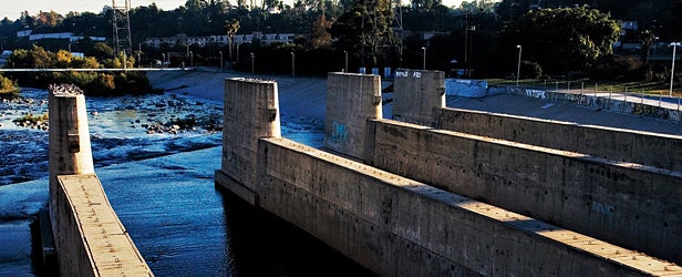
TWO YEARS AGO, some friends and I paddled 51 miles of the Los Angeles River, past the back lots of Warner Bros. and Universal studios, past the chemical refineries, and, finally, to within sight of the Queen Mary, the cruise ship turned hotel in Long Beach Harbor. Our course was a ribbon of algae-choked water in a 400-foot-wide, graffiti-lined concrete basin. If you’ve seen Grease or Terminator 2, you’ve seen the L.A. River. Its paved riverbed served as the set for a hot-rod race in the former and Schwarzenegger’s motorcycle-vs.-big-rig chase in the latter.
We, too, saw vehicles in the river: maintenance trucks removing plastic bags and spray-paint cans. We also saw great blue herons and black-necked stilts, as well as stranger native inhabitants. One guy camping on an island gave me the lowdown on the community of homeless people living there. He was naked. His pet teddy bear, which was pink, floated nearby, tethered to shore. Following our chat I paddled back into the water but was interrupted: A police helicopter hovered overhead, and over the loudspeaker the pilot ordered me to shore.
Paddling the Los Angeles River is illegal because, technically speaking, it’s not a river at all but, rather, a “flood-control facility.” In the twenties and thirties, it was still a naturally flooding river that ran approximately 50 miles from the San Fernando Valley to Long Beach and inundated the city several times. So in 1938 the Army Corps of Engineers paved the channel to move water out of the city as quickly as possible. Which is highly ironic; since then, the city has spent billions piping water in from the Owens Valley and the Colorado River.
Now rain courses into the concrete-lined ditch, which promptly floods—and escaping a flooding L.A. River is like trying to climb the walls of a water slide. Rescues and drownings are not infrequent. As a flood-control facility, it works beautifully. As an ecological habitat and a playground, it’s a disaster.
Our expedition aimed to call attention to a 2008 Corps decision that could strip parts of the river of its Clean Water Act protections. The Corps had argued it might not have jurisdiction to prosecute polluters because the river is a nonnavigable waterway—the criteria for a river to be afforded protection under the Clean Water Act. We set out to prove the river’s navigability by… navigating it. It was a satire of a river trip, but as with all good satire, it had a point.
In the end, the cops—likely swayed by the documentary film crew trailing us—let us complete our trip. A few weeks later, following a barrage of local news stories, the EPA offered special protections for the L.A. River.
There’s more good news, too. In 2007, the city government adopted a $2 billion revitalization master plan, prescribing everything from parkland and bike paths along the river to a rainwater-diversion scheme that would direct runoff into the ground, replenishing the aquifer. The plan will take more than 20 years to implement, but it could eventually mean the swapping of some concrete banks for a vegetation-lined riverbed.
The utopian vision has been slow to develop, due to budget shortages, but last year the city invested $17 million in a six-acre riverside parcel that will join two other recently created parks. “The political will to revitalize the river is there,” says Carol Armstrong, the Los Angeles River Master Plan project manager.
If our trip was any indication, the civic will is there, too. As the cops left the bank and our group stepped into our kayaks to continue downstream, the crowd that had gathered above let out a raucous cheer, glad that someone was treating the country’s ugliest waterway like, well, a river.