

We can all get in the rut of hiking, biking, or running the same stretch of wilderness over and over again. Setting your sights on a new path can be just the motivation you need to get out there and try something different. Thanks to the trail-building efforts of local crews and the support of regional and national organizations, many new routes have been built across the country recently, offering hikers a chance to check out a unique zone or return to a destination that’s been closed for a while. Here are some of our new favorites.
Fern Lake Trail, Colorado
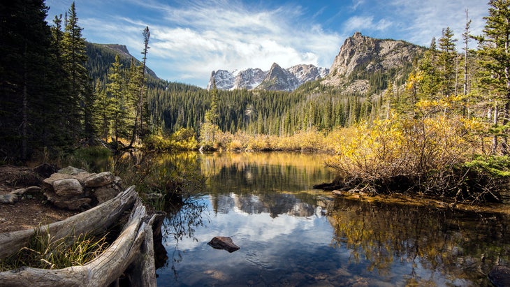
The , on the east side of Rocky Mountain National Park, is a Colorado classic. The 7.6-mile round-trip trail gains over 1,300 vertical feet before reaching the stunning Fern Lake, where you’ll have views of high peaks like 12,129-foot Notchtop and 12,331-foot Knobtop. This portion of the park burned in the East Troublesome Fire in 2020, and all the trails in the area were closed last year as crews worked to repair the damage and assess the safety of downed trees. Fern Lake Trail reopened last summer, offering access to picturesque sights along the way, including Cub Lake and Fern Lake.
Yaqui Ridge Trail, Arizona
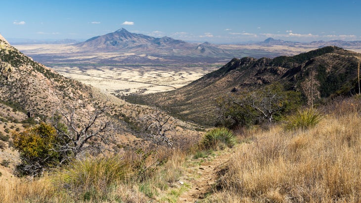
The southernmost segment of the 800-mile Arizona National Scenic Trail recently reopened to hikers after a multiyear closure. The , which starts on the Mexico-Arizona border in the Huachuca Mountains within , was closed in July 2020 due to construction of the border wall. But after the wall’s development was halted, the two-mile round-trip section was completed, and it reopened on December 31, 2021. This is a stretch most utilized by long-distance hikers either starting or ending a thru-hike of the Arizona Trail, but it can be done as a day hike from Tuscon, too, with an elevation that tops out at 5,908 feet, affording sweeping views of the grasslands and mountain ranges of Sonora, Mexico.
Great Circle Trail, Maine
The officially opened last September, connecting previously existing trails into a new 30-mile loop on the , a 43,000-acre wilderness area outside the town of Millinocket. The route, which was first conceived in 2005, utilizes the Turtle Ridge Loop, Debsconeag Loop, and a section of the Appalachian Trail and climbs over 3,000 vertical feet. You can backpack the whole loop in multiple days—seven rustic campsites are located along it—or cover a portion in a day hike.
Rockin’ Roll Hatchie Trails, Tennessee
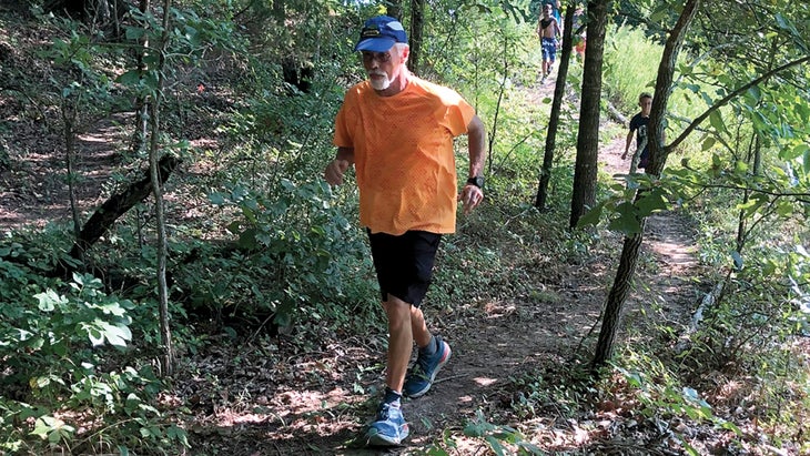
This 4.5-mile trail system caters to mountain bikers, hikers, and trail runners looking to explore Sugar Creek, a smaller tributary within the Wild and Scenic–designated Hatchie River watershed. Along the multi-use , you’ll find routes named after musical icons like Tina Turner and blues guitarist Sleepy John Estes, famous residents of the western town of Brownsville.
Rattlesnake Gulch Trail, Utah
Close to downtown Salt Lake City and near the mouth of Millcreek Canyon, the popular is loved by after-work dog walkers, runners, and mountain bikers descending from the Pipeline Trail. Because of its mixed use, builders from Trails Utah added a new Rattlesnake Gulch route last year that offers more switchbacks for cyclists. They also kept the original trail as an alternate route, to split up the crowds. As a hike, it’s about 3.5 miles round trip to an overlook with views of the Salt Lake Valley. There’s a from the U.S. Forest Service to access Millcreek Canyon.
Monument Trails, Arkansas
The , a collection of multi-use paths located within Arkansas State Parks, welcome hikers and trail runners, but mountain bikers will especially enjoy the swooping berms and rideable features. The first of the series was built at Hobbs State Park-Conservation Area in 2018, followed by the trails at Mount Nebo. In the past year, additional routes have been built at and , making up 17 new miles. In total, you’ll find about 74 miles of trails in all four parks, with more still in development.
Striped Peak Loop, Washington
has been a well-loved out-and-back hike on the Olympic Peninsula for years, but this year, hikers can turn it into a 7.5-mile loop, thanks to a new 3.5-mile connecting route. Located within Salt Creek Recreation Area, the trail project is the result of a three-year effort by over 200 volunteers from the Washington Trails Association. From the top of Striped Peak, you’ll have views of Crescent Bay, Salt Spring Island, and as far as Vancouver Island. History buffs will enjoy exploring an underground World War II bunker along the route. (Bring a headlamp if you want to check it out.)
Pfeiffer Falls Trail, California
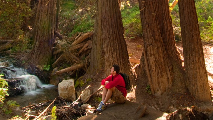
It’s been over 13 years since the Basin Complex Fire burned 162,818 acres along the state’s central coast, damaging and closing one of Big Sur’s most popular routes, the . In June 2021, however, the rebuilt trail opened to the public. A new segment of the path, just under a mile in length, connects to the 60-foot Pfeiffer Falls and crosses a new 70-foot-long walking bridge over Pfeiffer Redwood Creek. It then joins the Valley View Trail for a scenic 1.5-mile loop through the redwoods.
Eagle Creek Trail, Oregon
The legendary reopened in 2021 after being closed for three years due to damage from an eponymous fire that burned 48,831 acres in 2017. The highlight of this iconic trail is Punchbowl Falls, a stunning waterfall and swimming hole along the Columbia River Gorge. Reaching the falls is about 4.2 miles roundtrip, or you can make it a multiday, 26-mile round-trip adventure and connect to Whatum Lake. Extensive work was done by a collection of organizations—including the Pacific Crest Trail Association, Trailkeepers of Oregon, Washington Trails Association, and Friends of the Columbia Gorge—to repair and reopen the trail. Parking requires a $5 day-use fee.
Autism Nature Trail, New York
Everyone is welcome on the new at upstate New York’s , but the mile-long loop was specifically designed for those on the autism spectrum and those with a wide range of accessibility needs. Eight stations along the flat, accessible path offer interactive experiences, ranging from a sensory station filled with items found in the woods, to a musical station with nature-inspired instruments, to a design zone where you can build your own fort out of sticks and logs. There’s a $10 per vehicle fee to enter the state park.
Mount Philo Trail, Vermont
The route to the top of this 968-foot peak, in the 237-acre , was redesigned last year to accommodate hikers in a more sustainable way. The new path is wider and has a gentler grade and a more walkable crushed-stone surface. It’s a short hike for a magnificent view: you’ll get to the top in around a mile and about 500 vertical feet, ascending freshly built stone staircases to the summit.