I bought my first car when I was 24 years old during a move to Boulder, Colorado, for a job. She was a metallic-blue Honda Fit—a subcompact I could actually afford—and I was psyched to have wheels for mountain adventures.
Being an avid angler, backpacker, trail runner, and snowboarder, I made her my second home for high-alpine pursuits. She was a fuel-economy champion on a tight budget, a cozy bed in lightning storms, and a reliable-ish rig to reach hidden trailheads, camp spots, and rivers.
Now, though, I cringe at my younger self.
She was a Honda freaking Fit. But perhaps because I’d grown up driving in northern Minnesota (hello moose, black-ice, and squalls), I figured I could handle Colorado. So, I pushed her like the ATV she wasn’t, down dirt tracks she shouldn’t have been on, barely dodging would-be mistakes. It wasn’t until I braved a blizzard on Loveland Pass, topping out at 11,990 feet and nearly grazed a guardrail, that I knew it was time to trade up. It broke my heart to let her go, but I opted for an SUV with all-wheel drive, higher clearance, and better safety specs. I haven’t looked back since.
For adventurers like myself, cruising backcountry roads and off-grid highways comes with a major payoff: breathtaking vistas, zero crowds, and miles of solitude with prime access to wilderness. Yet, it also carries caveats, like having the proper skills, essential gear, and the right rig. Skimp on these, and BAM, you’re in SOS territory fast.
���ϳԹ��� of human error, some roads are simply trickier to navigate by nature. Bob Wilson, statewide communications manager for Colorado Department of Transportation (CDOT), says obstacles like weather, hairpin turns, steep climbs, missing or confusing signage, shoulder-edge drop offs, debris, potholes, and wildlife add complexity to backcountry driving. “These technical elements should be treated with extreme caution, no matter your skill or the conditions,” Wilson says.
The U.S. offers a plethora of spectacular, tantalizing routes in beautiful places. Here are eight stunners, from extreme tracks that switchback thousands of vertical feet to remote highways with no one else around. Some, I’ve done well equipped. Others are on my maybe list. Driving any one of these scenic, yet dangerous roads should be taken seriously. Our advice? Proceed with caution. If in doubt, stay home and gawk online instead.
Dalton Highway, Alaska
For: Prepared mountain-accustomed drivers with 4WD, snow tires, and chains
Length: 414 miles
Maximum Elevation: 4,653 feet
Get There: From Fairbanks, take Elliott Highway (AK Route 2) north to Livengood.
Best Time to Go: End of May into June
The Pay Off: Wildlife, no humans for miles, remarkable mountain peaks
Beware Of: Avalanches, infrequent services, wildlife
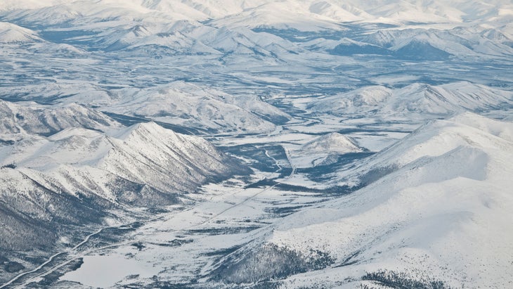
The Dalton Highway stretches 414 miles across northern Alaska from Livengood to Deadhorse and the Prudhoe Bay Oil Field on the Arctic Ocean. It winds through birch woodlands and spruce forests, crossing the Yukon River, Arctic Circle, and the Brooks Mountain Range, where it climbs over 3,000 feet to top out on Atigun Pass.
Originally constructed to support the trans-Alaska oil pipeline in the 1970s, it’s rugged, prone to avalanches, and has a number of non-conforming features. You’ll encounter 12 hills over 10 percent grade and several sharp curves. It’s mostly gravel and there’s no cell service. Frost heaves and other geological conditions promise a bumpy, pot-hole ridden ride, and with just three gas stops, you’ll travel up to 240 miles before your next fuel opportunity between Coldfoot and Dalton’s endpoint. Watch out for muskox, caribou, bears, wolves, and moose that traverse the ribbon of roadway and pipeline, and can crumple a vehicle.
Don’t Miss: Atigun Pass Summit at mile marker 244. Here, the Dalton crosses the Continental Divide where rivers to the north empty into the Arctic Ocean and rivers to the south dump into the Bering Sea. If you’re lucky with a perfect weather window, stay at any of the four along the way (mile markers 60, 115, 180, and 275).
Safety Tips: “Weather conditions make this road most challenging,” says Jeff Russell, Dalton district superintendent for Alaska Department of Transportation and Public Facilities (DOT&PF). “Winter storms have buried tractors and closed the road for several days,” he says. Russell recommends avoiding traveling during colder months for sightseeing and to be wary of caribou as they cross the road in herds without warning. The bottom line: “Understand that there are no emergency services,” he says. “People have died on that road waiting for transport to a hospital.”
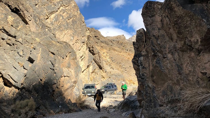
Black Bear Pass Road, Colorado
For: Experienced overlanders only, with modified 4WD, high clearance, and a short wheel base
Length: 11.1 miles
Maximum Elevation: 12,840 feet
Get There: From Silverton, head north on US Highway 550, then west at Red Mountain Pass on Forest Road 823 to the top.
Best Time to Go: August and September
The Pay Off: Proximity to waterfalls, astonishing box-canyon views
Beware Of: Shoulder-edge drop offs, ledges, hairpin turns, snow into July
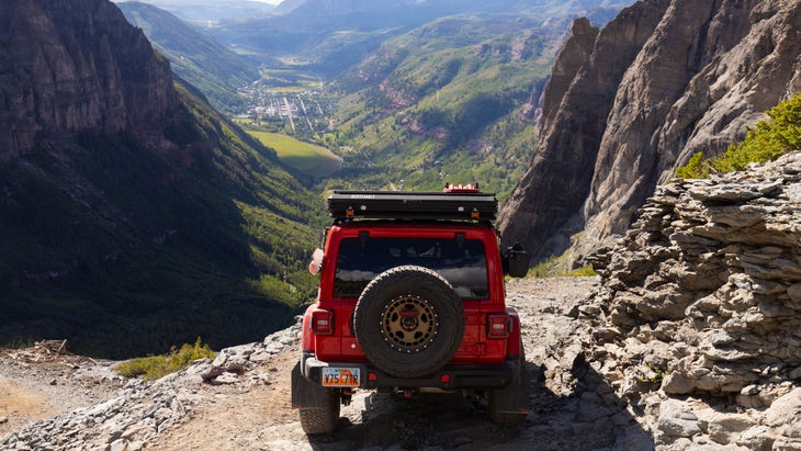
Colorado’s Black Bear Pass Road (Forest Road 648) is infamous for vehicle rollovers and SOS calls. In fact, off-road rescues here are getting out of hand, and Bill Masters, the state’s longest-serving sheriff, calls unprepared off-roaders who attempt it as —for good reason.
The road starts deep in the San Juans at Red Mountain Pass (Forest Road 823) off of US Highway 550 and climbs 3.2 miles and 1,822 feet to its high point on Black Bear Pass. This is where most people turn around. Some descend over 4,000 feet into Telluride.
For those who do, the road grows tighter and lumpier as it passes Ingram Lake into its basin. At mile 5.6, drivers hit a series of steep, technical rock ledges called the “Steps.” Masters, who often e-bikes the route from Telluride on his lunch break, has responded to dozens of emergency calls on this section. “From a vehicle, these drop offs look like they’re 10 feet,” he says. “A lot of people get here and freak out. They freeze with their foot on the brake. Add a thunderstorm to that, with that level of exposure, and people go over the side.”
After the Steps, the road turns into one-way, downhill only traffic for a mile through several tight, cliffedge switchbacks to Bridal Veil Power Plant. It meets Bridal Veil Falls and turns two-way again. For the inexperienced and underprepared, driving Black Bear Pass is like poking a bear with a sharp stick: deadly.
Don’t Miss: The shocking power of Bridal Veil Falls up close. Nearby, the power plant perches on a 400-foot cliff overlooking Telluride and produces sustainable energy for the town.
Safety Tips: Aside from extreme terrain, Masters says weather and conditions can be dicey—the road often closes from mud, rock, and snow slides, even during summer months when it’s open to drivers. “People get trapped on the pass with avalanches in front of them and behind them,” he says. “Make the assumption that you won’t make it to Telluride in your vehicle. Bring good hiking shoes so you can walk out in deep debris, because that might be your only option.”
Wilson, with CDOT, also recommends bringing: spare tires (and know how to change them), water, a sleeping bag, a shovel, tow cables, heavy-duty jacks, a fire extinguisher, tools, first-aid kit, stretch cords, and tire sealers, at minimum.
Beartooth Highway, Montana and Wyoming
For: Prepared mountain-accustomed drivers with AWD and all-weather tires
Length: 68.7 miles
Maximum Elevation: 10,947 feet
Get There: From Billings, take Interstate 90 to Laurel, then US Highway 212 southwest to Red Lodge.
Best Time to Go: July through mid September
The Pay Off: Lodgepole pine forests and alpine lakes rimmed in wildflower meadows
Beware Of: Extreme storms, hairpin turns, other motorists
The completely paved Beartooth Highway connects two small Montana towns—Red Lodge, to the northeast, and Cooke City, to the southwest—dipping across the Montana/Wyoming state line into Yellowstone National Park. You’ll face steep grades, hairpin turns, sheer drops, and narrow lanes as you cross through 20 peaks over 12,000 feet high. The road itself ascends 4,000 feet over 10 miles to reach Beartooth Pass, the 10,947-foot pinnacle, making it the highest highway in the Northern Rockies.
On a bluebird summer day, this road may seem undaunting for most mountain-accustomed drivers. But while it’s only open from June to October, don’t let Beartooth fool you. The route notoriously fields sudden snowstorms, fog banks, high winds, severe lightning, and lashing rain—unpredictable weather catalyzed, in part, by peaks in the surrounding Absaroka and Beartooth Ranges. Plus, grizzlies, bison, elk, moose, and bighorn sheep are just some of the wildlife hanging around.
It’s also a National Scenic Byways All-American Road leading to one of the most visited national parks in the U.S.
Don’t Miss: The quick 200-yard hike to Lake Creek Falls, an unmarked waterfall tumbling through a narrow gap on the north side of the highway, located 1.5 miles east from the junction of Beartooth and Chief Joseph Scenic Byway (WY Highway 296). Surrounding trails make for a solid pit stop to stretch your legs, and most people miss it.
Safety Tips: Road-closure information is a jurisdictional headache. The U.S. National Park Service (NPS), and the Montana and Wyoming departments of transportation (MDT and WYDOT, respectively) share maintenance responsibilities for Beartooth Highway. None keep a road-conditions livestream. According to the , it coordinates “closely” with the NPS to keep the road open, but its doesn’t show shutdowns. lists barebones intel on a 35-mile stretch of the route after it adopted the “orphan” section in 2014 when . The is your best bet for in-park closures. But above all, keep an eye on the to avoid getting hung up in a storm.
Steel Pass Road, Death Valley National Park, California
For: Experienced overlanders only, with modified 4WD, high clearance, and a short wheel base
Length: 29 miles
Maximum Elevation: 5,111 feet
Get There: From CA 190 at the junction for Scotty’s Castle Road, head north 38 miles, then turn right on Big Pine Road. Drive 34 more miles, and take a left on South Eureka Valley Road. Head 10 miles until you hit Eureka Dunes dry camp.
Best Time to Go: October through March
The Pay Off: Close-up canyon walls, no humans for miles, sweeping mountain vistas
Beware Of: Rock ledges, boulder fields, pinch points
This gnarly 4X4 track in California’s Death Valley National Park crosses its most remote northwestern area, and according to NPS ranger Brent Smith, without technical gear and the right ride, you won’t finish the drive. “Most people just don’t have the vehicles for it,” he says.
Steel Pass Road stretches 29 miles from Eureka Dunes Dry Camp, northeast, to Saline Valley Warm Springs campground, southwest, and generally takes four hours. From Eureka, you climb a narrow sandy wash toward Steel Pass through Dedeckera Canyon until you reach three rock benches, which require precise maneuvers to conquer steep grades and abrupt turns, simultaneously. The first ledge isn’t so bad. But if you don’t approach the second just right, you might crunch your vehicle into the volcanic rock on either side. The third step lies in a pinch point where only meticulous wheel alignment gets you through. “If you don’t hit it perfectly, you’ll probably lose something on the bottom of your vehicle,” Smith says.
The road continues up the canyon to a fourth pinch and a fork: according to Smith, who has driven this road several times on the job, right is harder, left is easier. Ascend through more wash to the top of a high-desert mesa sprinkled with small Joshua trees at 5,111 feet elevation. Cross this plateau (the drive’s easiest five miles, Smith says) before you descend into Saline Valley, shimmying through a red-band boulder field with careful tire placement.
Note: recent, extensive flood damage has erased many parts of this stretch, so check for updates and obey closure information.
Don’t Miss: Take a break at the mesa before you descend into Saline Valley. Here, you’ll get a dazzling panorama of the Inyo Mountain range, the western park boundary.
Safety Tips: According to Smith, it can take several hours for a rescue from the closest ranger station at Furnace Creek, over 100 miles away. There’s no cell service, so bring a satellite communication device in case of emergency. “There can be days where no one travels this route and it’s a really long walk to anywhere else in the park,” Smith says. “If you’re not familiar with the range, err on the side of caution and bring extra gas.” As far as weather goes, Death Valley gets the least amount of rain in the U.S. but when the clouds let loose, it comes in a deluge. “Don’t venture to Steel Pass in these conditions because it does flash flood and the boulders move around underneath you,” Smith warns.
Tail of the Dragon, Tennessee and North Carolina
For: Prepared mountain-accustomed drivers
Length: 11 miles
Maximum Elevation: 1,988 feet
Get There: From Asheville, head west on Interstate 40, then take US Highway 74 to NC Route 28 and Deals Gap.
Best Time to Go: April through October
The Pay Off: Old growth oak and hickory groves, serpentine, but paved, curves
Beware Of: Dramatic back-to-back curves, wildlife
This snaky ribbon of US Highway 129, dubbed “Tail of the Dragon” thanks to its 318 curves over just 11 miles, borders the Great Smoky Mountains National Park and Cherokee National Forest on the Tennessee/North Carolina state line.
It begins where NC Route 28 intersects with 129, coined “the mouth of the Dragon” by locals at Deals Gap, and climbs, dips, and twists almost 1,000 feet to finish at Tabcat Bridge in Bounty County, TN. Navigating its hairpin turns, blind crests, steep cambers, and double-backs demands utmost concentration—most curves are so sharp they’ve earned nicknames like Rockslide Corner, Gravity Cavity, and The Whip.
Steep rocky or forested embankments line both sides of the Dragon, there are no guardrails, and frequent summer-afternoon rain showers promise slick, perilous conditions. Though it’s paved with pull offs and warning signs—a safety initiative by the Tennessee Department of Transportation (TDOT) to reduce gravel on the road and caution motorists—even these features don’t prevent adrenaline junkies from launching off cliffs or into the oak, walnut, and hickory trees below.
Don’t Miss: Calderwood Overlook, slightly over nine miles into the drive, it has gorgeous views of Cheoah Dam below and Tennessee’s Smoky Mountains awash in fiery colors when leaves turn in fall.
Safety Tips: The 30-mile-per-hour speed limit exists for good reason, according to Mark Nagi, TDOT region one community relations officer. “Heed the warning and advisory signs posted at most curves, reverse curves, dips, and winding sections,” he says. “We’ve installed these to advise motorists of the features ahead.” Also, keep an eye out for deer, hogs, and black bears crossing the road as they travel through southern Appalachia. According to Nagi, 20 years’ worth of accident reports show several crashes involving wild animals.
River Road, Big Bend National Park, Texas
For: Experienced overlanders only, with modified 4WD and high clearance
Length: 51 miles
Maximum Elevation: 2,419 ���ڱ���
Get There: From Panther Junction Visitor Center, head east 15.7 miles until you reach the east entrance to River Road on your right. If you’ve hit Hot Springs Canyon Trailhead, you’ve gone too far.
Best Time to Go: October through March
The Pay Off: Primitive camp spots, no humans for miles, rich history
Beware Of: Extreme heat, sandy washes, flash floods
Over 51 miles, the scorching, 4X4-only River Road traverses the most remote part of Texas’ Big Bend National Park. Ironically, though it parallels the Rio Grande to the south, you won’t actually see water.
The route, typically a one-way journey, links the eastern Rio Grande Village to the western ranger outpost at Castolon, and crisscrosses creosote-sprinkled sandy washes and hardened lava flows through the Chihuahuan Desert. It takes at least four to five hours to drive, and hits several deep-bottomed arroyos with massive boulders at sharp grades. The NPS recommends making the trek only if you have, at minimum, 15-inch tire rims, high clearance, and four-wheel drive. “Even all-wheel-drive vehicles will get hung up in the silt and sediment because it’s unforgiving,” says Tom Vandenberg, chief of interpretation and visitor services at Big Bend. “In summer months during the rainy season, you could be driving a Sherman tank and not get through.”
River Road sits in the park’s lowlands, so though alpine climbs and cliffsides aren’t a threat, July to September is rife with isolated thunderstorms that cause frequent flash floods. “If it looks like it’ll rain in front of you, turn around,” Vandenberg says. “Often, sections become impassable until they dry out.”
Don’t Miss: , now an abandoned collection of empty buildings, used to be a bustling village home to early-1900s pioneers hunting for mercury. It’s located on the northern end of Mariscal Mountain about 18 miles in from River Road’s east entrance. If you’re lucky, snag a permit in person, 24 hours in advance, from Panther Junction. Here, sleep at the single, primitive across the road to catch the sunrise as it brushes across the vacant buildings.
Safety Tips: According to Vandenberg, summer temperatures on River Road are at least 10 degrees hotter than what’s reported from the park’s headquarters, almost 2,000 feet higher. They can top 115-degrees fahrenheit, or more, so he recommends driving the two-tracker in winter for optimal weather—if you attempt it. Also, confirm there’s air in your spare. “I can’t tell you how many people blow a tire, go to change it, and realize their backup is flat, too, because they haven’t looked at it in years,” Vandenberg says. Bring several gallons of water and wear protective clothing and proper footwear. “You need to be self reliant,” he says. “If you get stuck, stay by your vehicle. We don’t regularly patrol the road, but chances are someone will come along eventually, and out here, you’re a long way from help.”
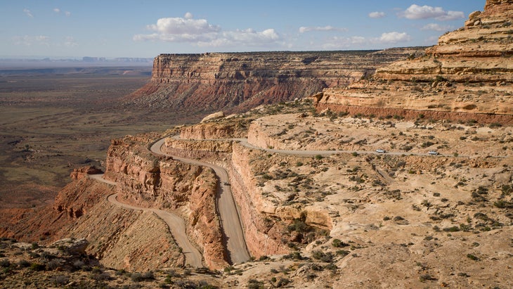
Moki Dugway, Utah
For: Prepared mountain-accustomed drivers
Length: 3 miles, including Muley Point
Maximum Elevation: 5,750 feet
Get There: From Moab, head south on US Highway 191 to Bluff, then take US Highway 163 west until it intersects with UT Route 261 to the north.
Best Time to Go: April through October
The Pay Off: Far-reaching canyon vistas, no Moab crowds
Beware Of: Sharp switchbacks, steep climbs, no guardrails
Moki Dugway is a three-mile gravel section of the paved UT Route 261, northwest of the Valley of the Gods, a series of red sandstone mesas, buttes, and spires sacred to the Navajo. Its name comes from “moqui,” the term Spanish explorers used to describe footholds local Puebloans chiseled to scale the crag, and “dugway” from the cliffedge road carved by ore miners in the 1950s.
The arduous, 11-percent-grade dugway switchbacks in 180-degree bends to climb 1,200 feet to the top of Cedar Mesa, revealing spectacular vistas of Utah’s meandering canyons as the valley floor drops away. Take the offshoot to Muley Point, Moki’s apex at 5,750 feet, for views of Colorado’s Ute Mountain to the east, and New Mexico’s Ship Rock to the southeast. But, beware: with the exception of the summit, the road doesn’t have guardrails to protect vehicles from shoulder-edge drop offs. Two-way traffic can make even the sturdiest drivers edge each other out from nerves.
Thunderstorms can cause severe runoff, and early spring freeze-thaw cycles generate rockfall. There’s also no cell service, so be ready to hike out if you get stuck.
Don’t Miss: Muley Point Overlook, not to be confused with Muley Point East. The latter gives you a glimpse of the San Juan River below, but if you drive a few minutes past it, the former, located at the end of the pointed rock stretching out from the mesa, gives you a much wider river panorama.
Safety Tips: “Drive the five mile-per-hour speed limit,” says Kevin Kitchen, Utah Department of Transportation (UDOT) region four senior communications manager. “This road requires focused driving at slow, consistent speed.” Use low gears, and ensure your brakes are in proper working condition and aren’t overheating. Also, don’t expect to turn around on the Moki Dugway: if you have a fear of heights, this drive is not for you, Kitchen warns. “Opinions about the Moki Dugway range from terror to ecstasy,” he says.
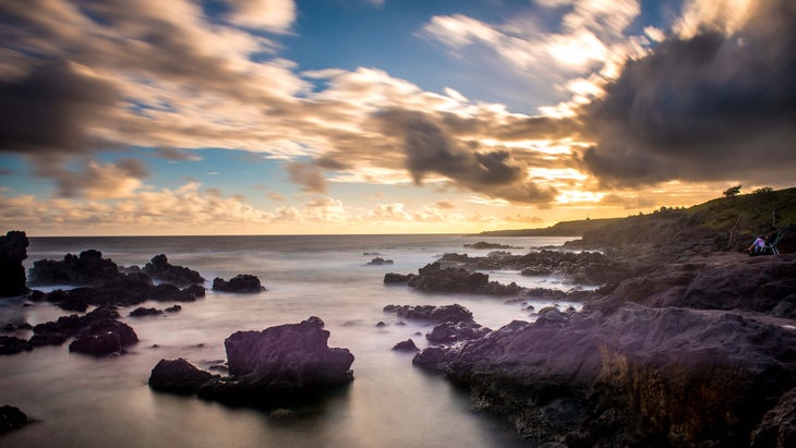
Road to Hana, Maui, Hawaii
For: Alert drivers prepared for narrow, single-lane bridges
Length: 34.3 miles
Maximum Elevation: 1,200 feet
Get There: From the town of Kahului, head east on Hana Highway (HI Route 36) about 17 miles, until it turns into HI Route 360, known as the Road to Hana.
Best Time to Go: December through March
The Pay Off: Tropical hikes, 18 waterfalls, rugged coastline
Beware Of: Single-car bridges, blind corners, tourists in rental cars
Hawaii’s curvy Road to Hana hugs Maui’s northeastern shore around Haleakalā National Park, and hints at the island’s trapped-in-time allure, before tourists ever came. But despite devastating wildfires in Lahaina last year, Hana and other spots remain open and encouraging of visitors.
The road starts at mile marker zero near Paʻia (your last chance for gas, to the north) where HI Route 36 turns into 360, and snakes toward Hana along the coast. With sea cliffs to the east and emerald peaks to the west, it’s as picturesque as it is dangerous, but not for the reasons you may think.
Yes, drivers tackle 617 white-knuckle switchbacks and blind corners, and cross 59 bridges, 46 of which only have one lane. And in poor weather conditions (usually rain or wind), it’s evermore crucial to obey the 25 mph speed limit.
However, with the rise in post-pandemic travel, Hana’s biggest danger lies in a tarmac battle between rental-car tourists clogging the artery and commuting locals who get from point A to B. In June 2021, 400 to 600 people per day travel the road, many of whom park illegally for views of gushing waterfalls, white-sand beaches, and jungle canopies, causing gridlock and accidents that stifle the narrow route. Hawaii’s Department of Transportation (HDOT) and tourism officials are considering toll, reservation, fine, or permit systems to regulate the kerfuffle, but it’s all moot until who currently fund it.
Don’t Miss: Pull off at Ho’okipa (meaning “hospitality” in Hawaiian) Beach Park near mile marker nine. From the lookout, you can view the best surfers in Maui riding cerulean waves below. Then, push onward to enjoy the road’s access to bamboo forests, coastal hikes, and gushing waterfalls.
Safety Tips: Maui local Jason Brewer, who makes the journey by moped mostly in the fall off-season for fun, says the trip has two logistical requirements. “You must make it to Hana as there are no gas stations available along the road,” he says. “A tank of gas will just get you there, and a tank will just get you home.” Also, know this: if you’re stopping to take photos and see the sights, pull over in designated areas and let locals pass. (They’ll be riding your butt, otherwise.)
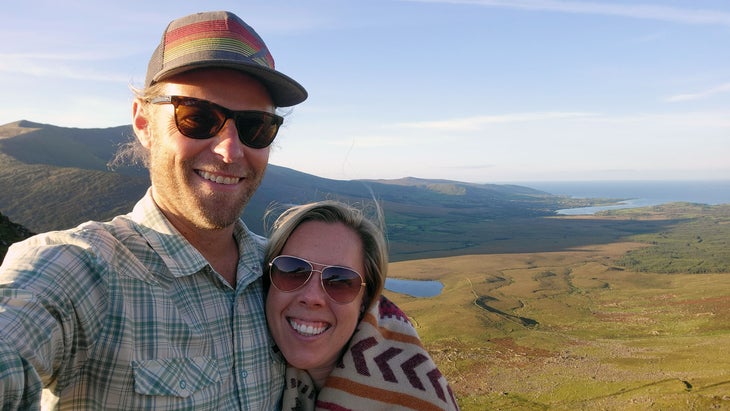
Patty Hodapp hadn’t been nervous on a road in a while. But last September, she and her husband snagged a Fiat Panda for an Ireland roadtrip. As they were retracing their steps over Conor Pass—a narrow, high lane in the Dingle Peninsula—it dumped torrential rain. Atlantic storms had socked the surrounding mountains in with fog. Sheep jumped fences in front of them, eager to reach low ground. And tourists zipped by at astronomical speeds. So they white-knuckled it down, swearing the whole way.