ϳԹ

The Hagwilget Canyon Bridge in Hazelton BC
(Photo: Northern BC Tourism/Andrew Strain)

Journey into The Great Wilderness


Published:  Updated: 
The Hagwilget Canyon Bridge in Hazelton BC
The Hagwilget Canyon Bridge in Hazelton, British Columbia. (Photo: Northern BC Tourism/Andrew Strain)
Sponsor Content: Destination British Columbia

Venture off the beaten path to northern British Columbia, where you’ll explore seemingly endless backcountry, meet diverse Indigenous peoples, and encounter a world of wildlife


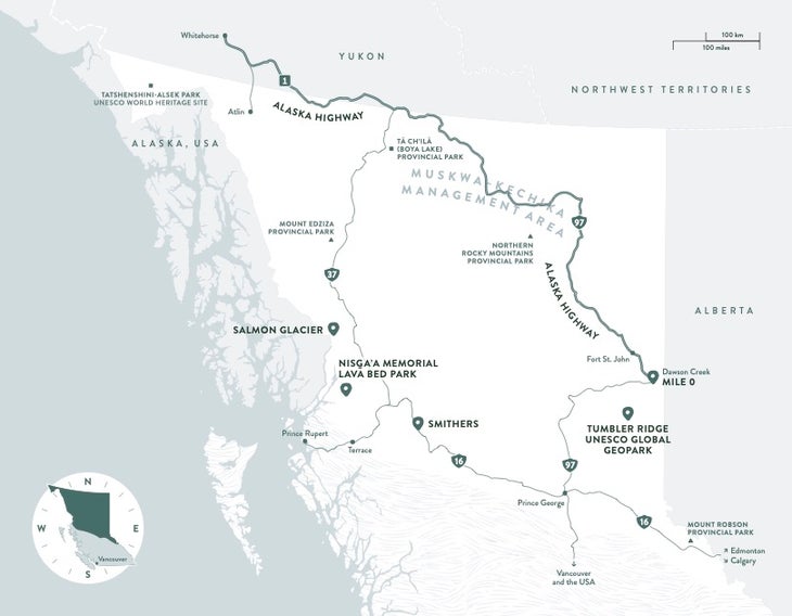
If you dream about destinations where towering mountains, dense boreal forests, and glacier-fed lakes stretch from horizon to horizon, set your sights on , a place for truly one-of-a-kind outdoor adventures. Located in the far north of British Columbia, Canada, this vast region, home to Indigenous Peoples since time immemorial, is a prime example of nature in its purest form. Here, the opportunity for adventure is as big as your ambition.

Hikers / trail runners in the Spectrum Range, Mount Edziza Provincial Park.
Mount Edziza Provincial Park. (Photo: Northern BC Tourism/Angela Percival)

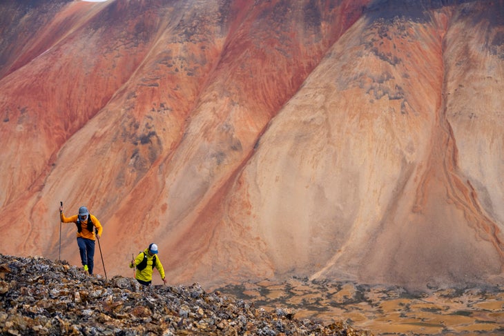
Experience what real solitude feels like in the multihued mountains of the Spectrum Range in Tenh Dẕetle Provincial Park (Mount Edziza Provincial Park). Answer the call of the meandering Tatshenshini River, where wild salmon still return to spawn—drawing grizzly bears and eagles to the banks of the river. Or marvel at nature’s immensity in the marshy lowlands, high alpine plateaus, and rugged mountains across 2,656 roadless square miles in Spatsizi Plateau Wilderness Park.

Ready to plan your own exploration of The Great Wilderness? These three experiences call to the most adventurous spirits.

Connect with the Rich Heritage of the Nisg̱a’a Lands

Visitors to the Nisg̱a’a Lands, near the southeastern border of the Alaska Panhandle, are often astounded when they first spot the area’s vast plains of lava. Covered in striking gold-colored lichen and moss, they’re the result of volcanic activity around 1700, when the Tseax Cone eruption created a lava flow that spread 20 miles northward. The eruption destroyed two Nisg̱a’a villages and, according to oral history, claimed approximately 2,000 community members, leaving a razed landscape of flat plains broken by hill-sized heaps of rubble and deep potholes filled with aquamarine river water.

Framed by the snow-capped Hazleton Mountains, Anhluut’ukwsim Lax̱mihl Angwinga’asanskwhl Nisg̱a’a (Nisg̱a’a Memorial Lava Bed Provincial Park) is part of Nisg̱a’a Lands. Follow the , which connects visitors to Nisg̱a’a villages, with cultural and scenic stops, including waterfalls, hot springs, drowned forest, and trailheads—providing Indigenous context to your experiences along the way. In Laxgalts’ap, one of four active Nisg̱a’a villages, visit the Hli Goothl Wilp-Adokshl Nisg̱a’a (Nisg̱a’a Museum) to learn about the rich heritage and traditions of the Nisg̱a’a Nation. Join a or watch carry on the legacy of their ancestors, carving feast bowls, pts’aan (totem poles), canoes, and other works of art. Then head to Gitwinksihlkw and cross the Nass River on the 400-foot pedestrian suspension bridge, which was the only access point to the village until 1995. Pedal the , a five-mile network of nine mountain biking trails with some of the best flows in the region. Don’t miss the panoramic views of the lava beds along the route. Then hike through old-growth forest to the rim of the Tseax Cone, which takes about four hours round-trip.

Carving in the village of Laxgalts'ap, Nisg̱a'a Nation.
Carving in the village of Laxgalts'ap, Nisg̱a'a Nation. (Photo: Destination BC/Grant Harder)
Looking out over the Nisg̱a'a Lava Beds and the Nass valley from the Saasak' Viewing Platform.
Bike to the Saasak' Viewing Platform to look out over the Nisg̱a'a Lava Beds and Nass Valley. (Photo: Northern BC Tourism/Andrew Strain)
Smoking salmon in the village of Gingolx.
Smoking salmon in the village of Gingolx. (Photo: Destination BC/Grant Harder)

Hike in the Shadow of the Highest Peak in the Canadian Rockies

At 12,972 feet, Mount Robson serves as an imposing backdrop to hiking trails that wind through its . The earliest known inhabitants of the region—the Texqakallt Nation—named this peak Yexyexéscen () because of the distinct layers of limestone, dolomite, shale, and quartzite that appear to wind up and around the mountain. This peak continues to be an important spiritual site for the local Indigenous community.

Climbers come from around the world to tackle this formidable peak. But you don’t need to be a climber to enjoy Mount Robson’s bounty. For hikers, the moderate 8.3-mile out-and-back Kinney Lake Trail is the big draw. Starting in temperate rainforest, the trail ascends just under 1,200 feet into the alpine. At the lake, you’re met with dramatic views of Whitehorn Mountain across the water as you pass below the shoulder of Mount Robson. The trail past Kinney Lake is currently under construction until summer 2025, but the view of Berg Glacier—an ice field that appears to flow down the side of Mount Robson—is worth planning another visit. At the bottom, the glacier calves icebergs into the milky-teal waters of Berg Lake. Can’t wait that long to see this iconic view of Mount Robson? that flies over Berg Lake and provides a unique vantage point to see the peak.

Paddle the Biggest Natural Lake in the Province

Tucked in the northwest corner of the province, the historic town of Atlin, on the east shore of Atlin Lake, is tantalizing. Long home of the Taku River Tlingit First Nation and briefly a hub to some 10,000 Klondike gold seekers, the tiny village now offers a gateway to a different kind of treasure. In summer, which offer up to 19 hours of daylight, Atlin is perfect for multiday paddling expeditions.

Surrounded by mountains, the lake serves up stunning vistas of the Llewellyn Glacier, the second-largest in the Juneau Icefield. Scattered islets and a winding shoreline provide protected campsites and boat-access hiking trails, and habitats for wildlife, including grizzly bears, moose, and caribou.

To access Áa Tlein Téix̱’i Provincial Park (Atlin Provincial Park), which surrounds the southern portion of Atlin Lake, put your boat in at Warm Bay. Despite the misleading name and the lake’s often deceptively calm appearance, the water is cold and sudden winds can whip up steep waves. If you don’t have sufficient paddling experience to safely tackle these waters, explore on foot via one of the park’s four main hiking trails.

Ready to journey to The Great Wilderness? Get more details on the adventures above and countless other ways to experience the captivating wilderness of northern British Columbia at .


Journey into The Great Wilderness, the northernmost area of British Columbia, Canada, where adventures await curious wanderers. Immerse yourself in a place where Indigenous culture is deeply rooted in the vast lands, an extraordinary landscape of jagged mountains, glittering glaciers, booming waterways, and diverse wildlife. Learn more at .

Continue Exploring British Columbia

The Most Epic Road Trip in North America

Lead Photo: Northern BC Tourism/Andrew Strain