

As of press time, the trails and campsites mentioned in this piece were open. To check for safety protocols and potential closures, check state websites.��
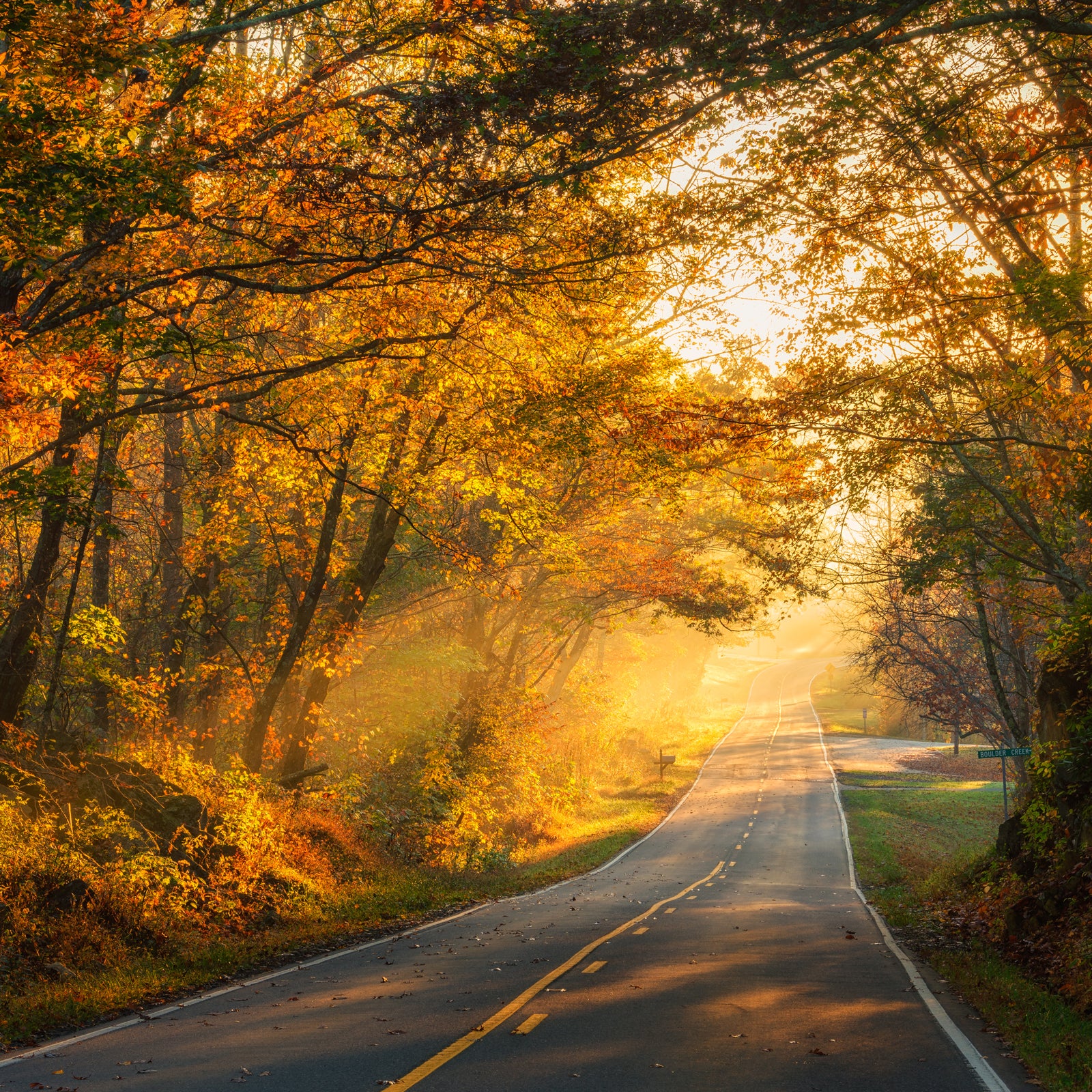
Growing up in the mountains of North Carolina, I lived close to Highway 19E, a stretch of road that begins a short distance north of Asheville��and ends in Bluff City, Tennessee. At first glance, 19E is a practical country road. It’s the sort of expanse��travel writer William Least Heat-Moon might have called a “blue highway,” one of America’s old back roads marked in blue on the maps and��almanacs travelers used before the era of apps.
For those who know where to look, the road is like a multipurpose tool. Although it’s little known outside of the region, the 60-mile stretch connects as much natural diversity as any locale in southern Appalachia. It links southeastern superlatives: the highest point east of the Mississippi, 6,683-foot Mount Mitchell, which you can reach via one of the region’s highest-elevation trails; the most rugged mountain cliffs in the region, located on 5,946-foot Grandfather Mountain; some of the best tailrace fly-fishing in the Tennessee Valley; and, depending on which thru-hiker you ask, the most beautiful section of the Appalachian Trail.
The two-hour corridor begins 31 miles north of Asheville, where Highways 19W and 19E meet in the small mountain community of��Cane River, and then runs 76.5 miles west to Bluff City. But the best section for the outdoors person is from miles 6 to 61,��connecting��eight adventures never more than 25 minutes off 19E.
The ���ϳԹ��� Stops��
1) Mile 6.2: Pisgah National Forest and Mount Mitchell State Park
A strenuous one-way route that ends in , Black Mountain Crest Trail��leads to the park’s namesake mountain. The trail earns its local nickname, the Death March,��in only 11.3 miles��and involves crossing over five 6,000-plus-foot��peaks, including 6,647-foot Mount Craig, the second highest in the Southeast.��Since it’s not a round-trip hike, it��makes for a challenging 22.6 mile out-and-back, so plan��a��leisurely��two-to-three-day trip��around four first-come, first-served primitive campsites along the Pisgah National Forest section of the trail before it enters the state park at mile 7.9. Once you hit the park, you’ll find nine sites that need to be in advance. Be prepared for exposed narrow ridgelines, tough ascents, and breathtaking views of the Blue Ridge Parkway.
Need to know: Don’t underestimate the weather here. While the altitude may seem low to a western hiker,��the climate��varies wildly in��the valleys��and changes rapidly along the ridgeline. Also, be aware that this is a relatively dry trail: water is only available at three spots.
Getting there: Turn off at mile 6.9 of North Carolina Highway 197 South to Bowlen’s Creek (State Route��1109). Park in the area on Water Shed Road near a hikers-only national-forest sign that marks Black Mountain Crest Trailhead.
2) Mile 26.2: Linville Gorge Wilderness��
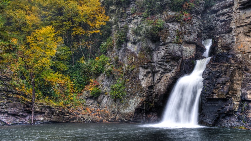
Every region of the country seems to have its own little Grand Canyon.�� is North Carolina’s. Most famous for the 150-foot Linville Falls at the northern end of the gorge, Linville River is bound by canyon walls and punctuated by cascades, waterfalls, and blue-green pools. The 11.4-mile Linville Gorge Trail tracks the length of the gorge downstream from��the falls, but you’ll have to hike in for access. Choose from one of six trails, ranging from 0.75 mile to 2.7 miles, that all connect the gorge trail. But don’t let the length of the access trails fool you: these are steep hikes. The Pinch-In Trail, for instance, leads directly to the Linville Gorge Trail after a descent of more than 1,700 feet in just under 1.5 miles. Want a gentler hike? Try the well-trodden, 2.4-mile Babel Tower Trail. At the bottom of its��850-foot descent, you’ll find the ten-foot-tall Babel Tower Falls��and a popular swimming hole.
There are plenty of campsites within��Linville Gorge, but you’ll need to reserve an overnight permit for camping on weekends and during holidays from May 1 through October 31—and they fill up fast. For a permit, call the Pisgah National Forest Grandfather Ranger District office at 828-652-2144. You can reserve a permit (from $20) on the first working day of the previous month.
Need to know: Since Linville Gorge is managed as a wilderness area, trails aren’t maintained.
Getting there: Exit on Highway 194 North/Three Mile Highway to U.S. 221 South. Three miles later, take the exit for Highway 183 South before heading onto Kistler Memorial Highway (State Route 1238), where you’ll find pullouts.
3) Mile 26.2: The Brown Mountain Lights��
Southern Appalachia is haunted. The Brown Mountain Lights, a series of irregular, ghostly lights that are said to appear and flicker over Brown Mountain after dark, are��a regional legend. You might catch a glimpse of them from Wiseman’s View over Linville Gorge. The best time to try to see them is from September to November.
Getting there: Exit on Highway 194 North/Three Mile Highway to U.S. 221 South, Highway 183 South, and then��Kistler Memorial Highway. Pullouts will lead you to the Wiseman’s View overlook.
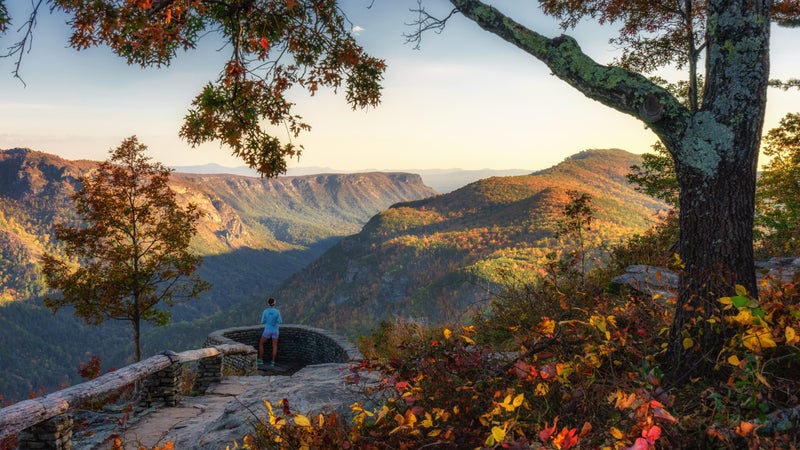
4) Mile 42.9: Grandfather Mountain State Park
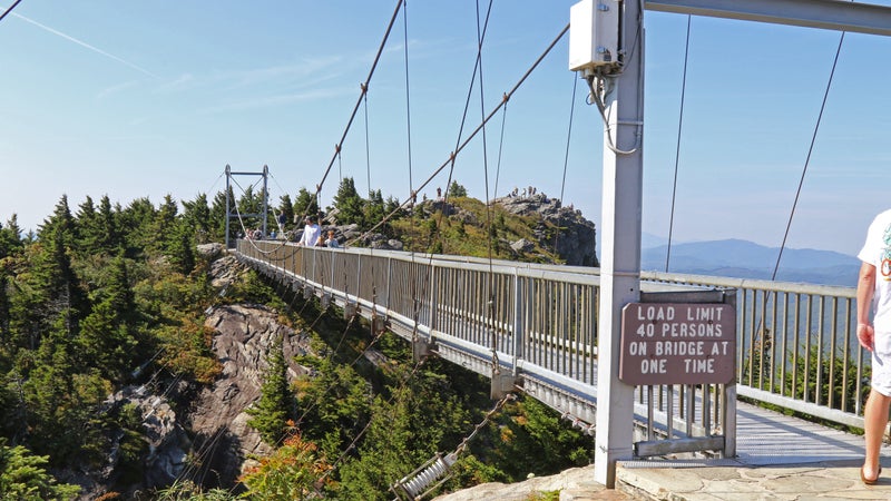
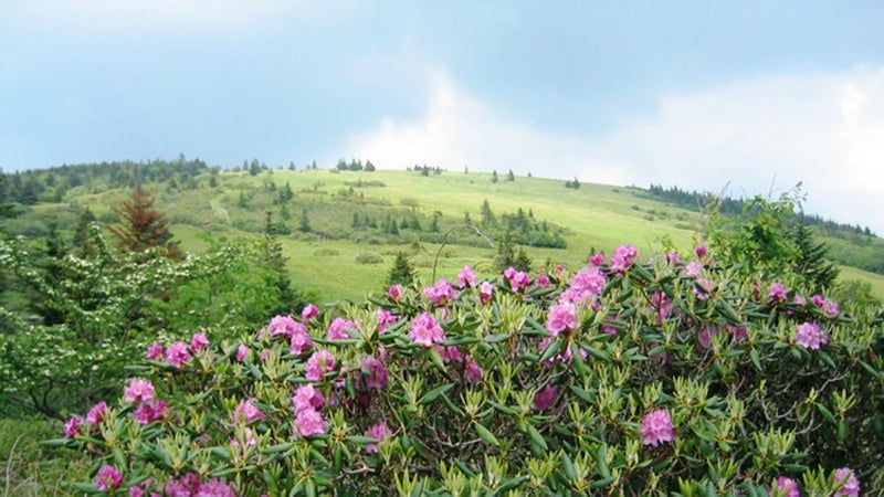
To the east of Highway 19E, watches over the headwaters of the Watauga River. To the west, the peak rises above Pisgah National Forest and one of the Blue Ridge Parkway’s most photographed locations, the . While the park includes more than 12 miles of trails, the best views are from the 3.6-mile Profile Trail. In the spring, the trail’s lower reaches glow with wildflowers and pungent ramps (but��it’s illegal to��harvest ramps��inside the state park). The route ends at the 2.4-mile Grandfather Mountain Trail, the popular crest hike that traces a narrow line across gray cliffs, up ladders and cables, and over boulders. You’ll follow it through the Chute,��a steep, hand-over-hand ascent through a fissure in the uppermost cliffs. When you come to the Attic Window—you’ll know it when you see it—climb up to the point that marks the top frame of the window��for incredible views of the national forest. The highest vantage point in the state park, though, is found��at the end of the trail, the 5,946-foot Calloway Peak summit, which offers a vista west of the mountain.
Alternatively, skip the hike to the Grandfather Mountain Trail and arrive��at the trailhead via the instead. The privately owned, 228-foot-long��suspension crossing��passes above an 80-foot drop and��is open almost every day of the year, even when the state park is closed. In addition to its bridge, the attraction is popular for area wildlife—you’ll likely see cougars, black bears, river otters, bald eagles, and elk.
In the park, campsites are largely nestled in the ridgeline forests. To some degree, trees on the��mountaintop help block the wind, which is important since high��gusts��are regularly��clocked on the peak. Post up at the campsite (from $15), the closest to Calloway Peak. To camp in one of the 13 backcountry sites in Grandfather, you’ll need to book a space or by calling 877-722-6762. Bring a cookstove, as no fires are allowed along the ridgeline.
Need to know: Be aware that the state park is closed in the winter, and its ladders and short stone climbs can be dangerous in the rain or heavy fog that cap the mountaintop throughout the year.
Getting there: Exit on Highway 194 North in Elk Park and continue on to��Highway 184 South and Highway 105 North. Look for the state park’s official parking area.
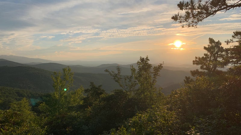
5) Mile 44.7 and 49.6: Roan Highlands
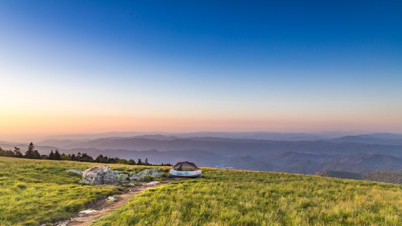
Two hikes will get you to the Roan Highlands, a 20-mile massif part of��the Appalachian��Bald Mountains. These almost treeless ridges are carpeted in grasses and short shrubs, leaving room for 360-degree views. The longer approach, an AT��section hike between Carvers Gap and Highway 19E, is 16.7 miles. This route takes you across Little Hump Mountain, through historic Yellow Gap, where the passed en route to a Revolutionary War battle at King’s Mountain, and up across the highlands themselves. Just downhill from the gap is the site of the former .
The quickest way to the Balds, though, is via a popular short AT hike just��2.5 miles east of Carvers Gap. You’ll find the gap where the AT bisects Tennessee State Route��143 South, also called Roan Road, at the top of Roan Mountain. Head south. The crowds taper a bit after you cross the first of the three most famous balds of the highlands, Round Bald. It’s not uncommon to see a tent pitched on Jane Bald, but for the best views of 6,286-foot Roan High Knob, climb to Grassy Ridge Bald via a short, signed trail that branches off from the AT. From there, Grandfather Mountain and the mouth of the Linville Gorge are easy to spot. On a clear day, you’ll also see the ridgeline of Black Mountain. The day hikers who make it to Grassy Ridge Bald often stop for lunch by the boulder with a plaque commemorating Cornelius Rex Peake, one of the highlands’ early conservation benefactors. But follow the trail for another quarter-mile, and you’ll find yourself on a hidden section that winds through rhododendrons to a wide saddleback ridge with a stone fire pit and great views of Grandfather Mountain.
You have your choice of five shelters on the AT, from the Roan High Knob Shelter, which, at 6,285 feet, is the highest-elevation shelter on the AT, to one at Laurel Falls. While the iconic Overmountain Shelter is closed now, the field next to the shelter has always provided overflow camping and is still available—just pitch at a safe distance, at least 40 feet away.
Getting there: The Appalachian Trail crosses 19E at mile 44.7. To reach Carvers Gap, exit at mile 49.6 on Tennessee State Route 143 South. Or you’ll find small parking areas on either side of 19E at mile 44.7 and a larger parking area at Carvers Gap. You can get��to and from either point with the service out of , a popular hostel. Be aware that both parking areas have had a reputation for vandalism in recent years, particularly��on 19E at mile 44.7.
6) Mile 49.6: Roan Mountain State Park
Comprising part of the Roan Highlands that crosses state lines into Tennessee, isn’t just a good base camp for local adventures off of 19E, it’s a destination in its own right. It offers 12 miles of hiking trails and three miles of biking routes that run from easy to strenuous. There’s also a swimming area and fishing options at the northern end of Doe River, which flows through the park. You can one of 30 cabins (from $90) or��107 campsites that have picnic tables, grills, and access to showers (from $15).
Getting there: Exit on Tennessee State Route 143 South, and head 1.7 miles to the park entrance.
7) Mile 61.8: Laurel Falls in the Pond Mountain Wilderness
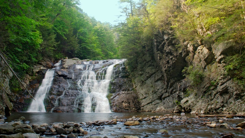
The to the popular Laurel Falls and back is only 4.8 miles. The falls themselves are 40 feet high and 50 feet wide, but in the summer, when the water is low, they form two cascades that splash down mossy rock shelves.
Getting there: Exit on U.S. 321 South, and drive 1.5 miles to the Laurel Falls Trailhead.
8) Mile 65 and Mile 76.5: Watauga River and South Holston River
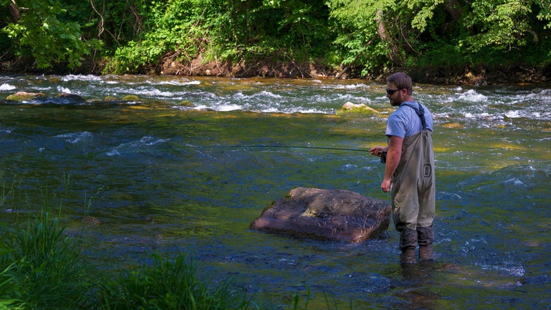
The Watauga River in Elizabethton and the South Holston River in Bluff City offer excellent tailrace fishing, which involves angling just below natural or man-made dams. Watauga is known for its rainbow trout and Mother’s Day caddis hatch, as well as its wading access. To do the South Holston justice, you’ll likely have to float the river, but it’s worth it. South Holston has a reputation for monster brown trout and its hatches of sulphurs.
Need to know: Fishing in and requires a valid license and a trout stamp that can be purchased online. Also, these are tailrace waters, so you’ll need to plan your trip around dam-release schedules.
Getting there: The rivers intersect 19E at mile 65 and 76.5.