

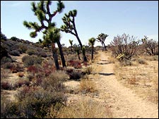
 View from the California Riding and Hiking Trail
 Q: Now that fall is here we’re thinking of taking a backpacking trip through the desert. Any hints on where we should go? What about day hikes?
— Nicole Frisbee,
Denver, Colorado
���ϳԹ��� Advisor:
A: Fall is one of the best times to hit the trails in parks like Joshua Tree and Death Valley. Summer heat obviously makes these parks off-limits as temperatures can easily hit 100-degrees Fahrenheit by 9 a.m. But in the fall, you can expect warm days and not-so-chilly nights—but do bring your fleece.
One of my favorite trails for this time of year is the California Riding and Hiking Trail in Joshua Tree. It’s an 11-mile out-and-back hike (22 miles round-trip) that takes you through the heart of the park where the views are unbeatable. You’ll gaze out on peaks like Ryan Mountain and be held breathless at the vast expanses that pour in from the Pinto Basin. Park at the Juniper Flats Backcountry lot, which is off Keys View Road. The trail starts here and dumps you off on Park Route 11 near White Tank Campground. Break up the 11-mile stretch and camp after 6.5 miles near Geology Tour Road. Park rules state you have to camp one mile from a road and 500 feet from the trail. Don’t let that discourage you: while this is a busier section of the park, the landscape is large enough to still swallow you whole. Water is an issue, so bring plenty—at least a gallon per person per day. The trail is mostly level for the entire time, and is rather wide (about three feet or so toward the end), making it a good hike for newbies. The trail is also well marked, but do get a map at one of the ranger stations. For more information, call the park at 760-367-5500 or visit . For day hikes, an absolute must is a trip to Death Valley’s Eureka Dunes. This loop is short—only three miles—but well worth the trip. The dunes aren’t terribly high, but they’re situated smack in the middle of the Eureka Valley in the northern section of the park. To get to the trailhead from the popular Scotty’s Castle Road, you’ll need to head down Death Valley Road (North Entrance Highway) to Big Pine Road. From there you head for about 30 miles to South Eureka Valley Road. The trail starts at the end of the road. If you want to climb up to the 3,500-foot high point you’ll be facing a 1.5 mile route up loose sand along knife ridges for 600 vertical feet or so. For more information, call the park at 760-786-3200 or visit . Planning a trip of your own?