


Horsepacking in Navajoland

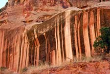
Drop over the South Rim and ride along the sandy floor of Arizona’s Canyon de Chelly National Monument, where the sparse grass is studded with cactus and 800-plus-year-old Anasazi ruins cling to the wind-scoured red cliffs. Make camp among the cottonwoods at the head of adjoining Canyon del Muerto, 800 feel below the rim, and watch the last light bounce off red rocks, painting white horses pink.
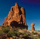
You’ll tour these ancient canyons on the first portion of a three-stage horseback trek through the Navajo country of Arizona and Utah. Outfitter Hel Heaton carries the load with pickups and horse trailers, so you can leapfrog across the landscape to ride only the most spectacular country. Monument Valley on the Utah/Arizona border, the quintessential Western landscape, is the next stop for two days of riding among the towering rock spires. A two-hour road trip brings you to 10,388-foot Navajo Mountain in Utah for another two days of riding northward into the maze of canyons that comprise the Glen Canyon National Recreational Area watershed. Along the way, you’ll pitch your own tent, groom and saddle your horse, do the dishes after a hearty meat-and-potatoes meal, and scale plenty of rocks to gain sweeping views of the countryside. The coda for the trek: You’ll descend the rocky wash of Piute Creek to the San Juan River, swap your horse for a speedboat, skim the last 50 miles on Lake Powell, and return to Page, Arizona.
The eight-day trip beings and ends in Page and runs around $170 per person per day. Call Mel Heaton’s Honeymoon Trail Company (520.643.7292) or Equitour (800.545.0019).
Mojave National Preserve
The 1.6 million acres of southern California’s Mojave National Preserve embrace jagged granite peaks of 8,000 feet, sparse creosote lowlands of 1,000 feet, and, best of all, desert solitude so profound that the skittering of a fat chuckwalla lizard can startle you from deep revelry. Got in the shoulder season—late September through December—and you’ll have perfect weather for hiking, mountain biking on jeep roads, and car camping beneath huge starry skies.
Pick up a map at the preserve’s Baker Information Center (760.733.4040) on I-15, about 70 miles east of Barstow, then head south 43 miles on paved Kelbaker Road through veritable forests Joshua Tree to the turnoff for the 45-square-mile sandbox known as Kelso Dunes. Scramble up 600-plus-foot sandy peaks for a great view of the Providence Mountains and listen for an acoustic effect of the wind that sounds like a quiet timpani roll.
For solitude, clatter down any dirt road and camp for free anywhere that’s been used before (rangers can suggest spots). Two developed camps ($10), both with water and toilets, are accessible via dirt roads. In warm weather, choose 5,600-foot Mid-Hills Campground, with sites shaded by scraggly pinon and juniper groves. Hole-in-the-Wall, eight miles south, is 1,200 feet lower and several degrees warmer, and features Swiss cheese rock formations that make for easy scrambling. Forge a 21-mile mountain-biking loop between the two campgrounds: ride craggy Wild Horse Canyon Road in one directions and Black Canyon Road in the other, or hike the eight-mile trail between them.
Be sure, one hot afternoon, to head south to Mitchell Caverns in the Providence Mountains, where the stalactite-filled chambers are always cool (call 760.928.2586 for tour information). Finally, splurge for at least one night in Hotel Nipton, just northeast of the preserve. The four-room circa 1904 abode oozes quirky historical ambience, with dark tiled floors, old black-and-white photography on the walls, and a lobby brimming with desert-themed reading materials. Doubles with shared outdoor hot tubs provided front-row seats for the nighttime star show.
Utah Canyons
There are places on every map that are best visited on a whim, unfettered by careful planning. Southeastern Utah’s maze of twisting canyons and sprawling mesatops is one of them. A friend and I had no particular destination in mind, just a guiding mantra—”anywhere but Moab”—when we stumbled into a pocket of the state inexplicably overlooked by nearly everyone.
Our entry point was the shady village of Bluff on the San Juan River. It’s home to a couple of trading posts-cum-cafes and serves as the put-in for Wild Rivers Expeditions’s (800.422.7654) full- and multiday raft trips on the Class II-IV San Juan. From Bluff, we took deserted Utah 261 west about five miles north to where it began switchbacking 1,110 feet up to the top of Cedar Mesa, a sandstone escarpment with views all the way south to Monument Valley.
Here a thick pinon and juniper scrub masks the snaking canyon system of Grand Gulch Primitive Area, just west of Utah 261. A three- to four-day hike starts from the Kane Gulch Ranger Station (435.587.2141) on Utah 261 and cuts a winding, 23-mile route down Kane Gulch to Grand Gulch, up Bullet Canyon, and back to Utah 261. Pick up a $2 topo map and an $8-per-person backcountry permit (reserved by calling 435.587.1532) and check on shuttle options. Fifteen miles north of Kane Gulch is Natural Bridges National Monument, home to three massive sandstone bridges accessed via an 8.2-mile loop hike. The sole campground has 13 first-come, first-served sites ($10).
The closest thing to civilization is Fry Canyon Lodge (435.259.5334), a café/motel/general store a half hour northwest of Natural Bridge on Utah 95. While you can down lemonade and hamburgers, you can contemplate your next move on the gigantic wall map of Fry County. But don’t study it too carefully—your best approach is simply to let the byways lead you.