

IT’S TRUE YOU CAN’T DRIVE to the ends of the earth, but the Yukon’s Dempster Highway will take you as close as you’d ever want to go. Beginning near Dawson City, this lonesome strip of loose gravel stretches 461 miles northeast, ending just shy of the Arctic Ocean in Inuvik, Northwest Territories. Completed in 1978 to reach oil and gas deposits, the Dempster remains the gateway to an otherwise untouched swath of mountainous tundra. Drive it and you’ll cross the Continental Divide (three times), the Arctic Circle, and two mountain ranges. Its reputation as the longest, most adventurous road in North America isn’t unwarranted, given the gaping potholes, tire-piercing shale, and only four gas stations. Here’s our suggested one-way, three-night itinerary and a bit of advice: Take a rental, reset the odometer, and load up on maps. You’re on your own getting back. At right, ten highlights along one of the gnarliest drives on earth. ACCESS + RESOURCES
ROAD WISDOM Make all your arrangements in Whitehorse, 298 miles southeast of the Dempster’s start. Norcan Leasing Ltd. (867-668-2137, ) rents mid- and full-size SUVs, starting at $40 a day, and Arctic Motorcycle Tours (867-633-3344, ) rents Kawasaki KLR 650 dual-sport motorcycles ($115 per day). Once you hit the highway, the only services are at Eagle Plains, Fort McPherson, Tsiigehtchic, and Inuvik. Be sure to carry extra fuel, several spare tires, and a copy of The Milepost (), the definitive guide to all northern roads. Stop at the visitor center (867-993-5566) in Dawson City for updated highway conditions and a 14-page, mile-by-mile pamphlet. CAMPGROUNDS The Tombstone, Engineer Creek, and Rock River campgrounds ($12 per night) operate on a first-come, first-served basis, with government-maintained kitchen shelters, toilets, and pump water.
MILE HIGH
1. MILE 45 The jagged granite peaks of Tombstone Territorial Park have the only marked trails along the entire Dempster. Pitch your tent at the 31-site roadside campground, but if you want to bag 7,195-foot TOMBSTONE MOUNTAIN (a three-day endeavor), pack the tent and hike ten miles to a backcountry site at Talus Lake.
2. MILE 72 The confluence of the east and west forks of the Blackstone River offers some of THE BEST FISHING for arctic grayling you’ll find. Hop out of the car, tie on a fly, and start casting.
3. MILE 122 There’s good reason to gawk at the red-limestone dolomite pillars at Engineer Creek: Rare PEREGRINE FALCONS nest on the craggy outcropping called Sapper Hill. Bed down at one of 15 roadside campsites nestled among the spruce.
4. MILE 230 The “town” of Eagle Plains marks the HALFWAY POINT. This glorified rest stop offers everything your average freeway exit has: a hotel, a restaurant, a full-service garage, and gas, gas, gas.
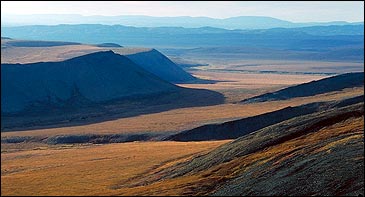
5. MILE 252 Take the obligatory portrait at the marker that denotes the ARCTIC CIRCLE (66° 33′ N). Exactly four miles farther up the road, pull over at the turnout and pick up the steep three-mile trail to the top of 700-foot Mount Hare for sweeping views of the Mackenzie Delta.
6. MILE 277 Got deet? The 18-site ROCK RIVER CAMPGROUND is set in the steep, wind-protected, but very buggy gorge of the Richardson Mountains. If dining by campfire won’t do, catch dinner at James Creek, 21 miles up the road.
7. MILE 291 Grab the GPS and start navigating on foot across miles of trackless terrain that’ll take you into the interior of the RICHARDSON MOUNTAINS. With high winds, continuous permafrost, and a (stunted) tree line at just 2,500 feet, the Richardsons are the most Arctic-like region along the Dempster—probably the reason they’re some of the least visited peaks in North America.
8. MILE 342 Gas up at Fort McPherson (pop. 952), then swing by the FORT MCPHERSON TENT AND CANVAS COMPANY and check out their famous handmade tents and tepees.
9. MILE 378 Take a mandatory ferry ride across the mighty MACKENZIE RIVER, Canada’s longest (2,635 miles), which drains an entire fifth of the country. Its volume is rivaled only by the Mississippi and the Amazon.
10. MILE 461 The end. Spend a day or two in Inuvik—a full-blown oil town with a population of 3,296 and a network of surreal aboveground pipes. Take a flightseeing tour (867-777-3300, ) over the 5,200-square-mile Mackenzie Delta to Tuktoyaktuk, an Inuvialuit community on the ARCTIC OCEAN accessible by road only during the winter. You’ll see pingos (giant earth cones with hearts of ice) and plenty of wildlife: beluga whales, caribou, polar bears, and musk oxen.