

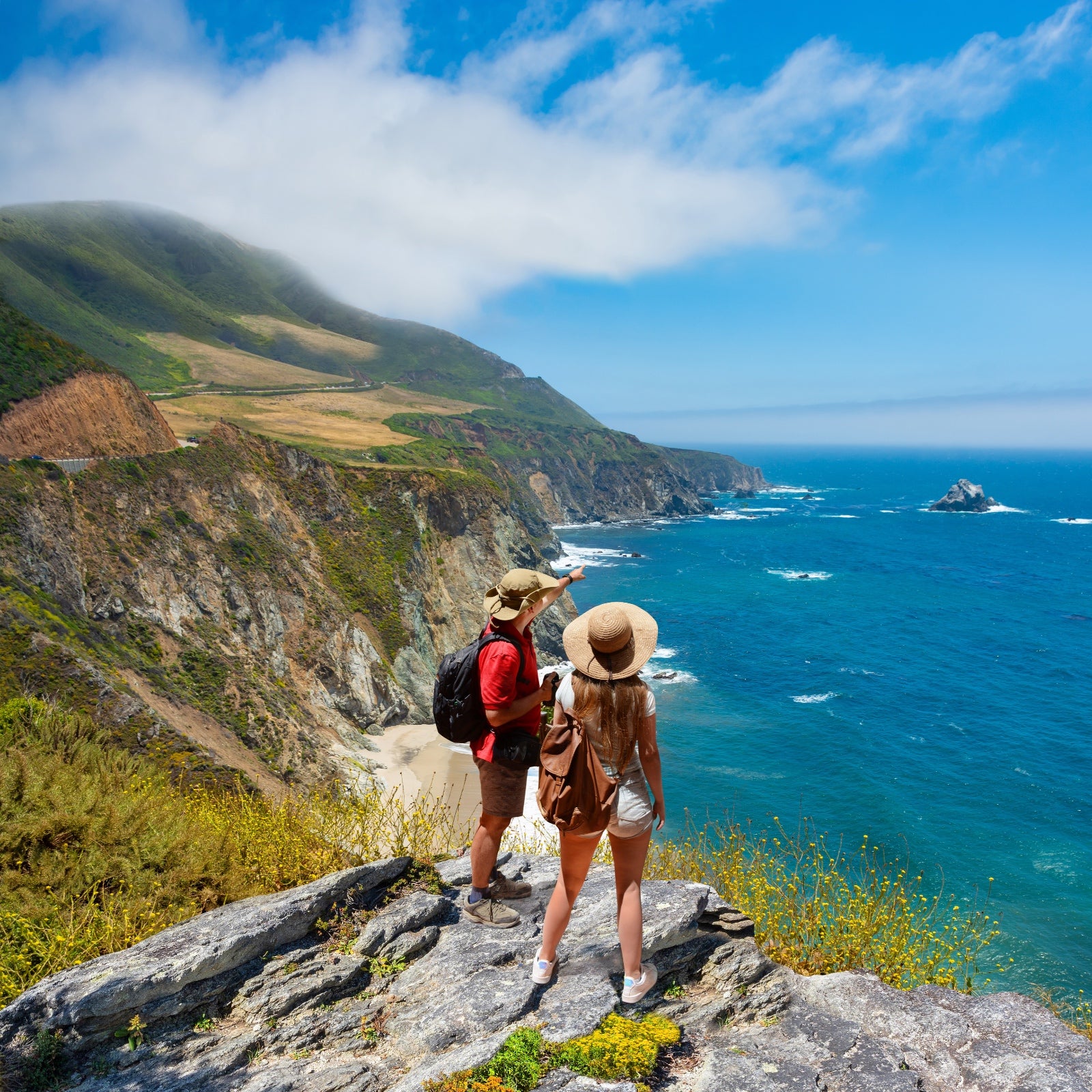
California is more massive and geologically diverse than many similarly sized countries, which makes for some incredible hiking choices. I lived in Los Angeles for 19 years and could head to ancient sequoia groves one weekend, wander oceanfront sand dunes the next, and then trek through the Joshua trees the weekend after that. All were less than a four-hour drive away.
Whether you want to stroll alongside brilliant alpine tarns or crane your neck up at the tallest trees on the planet, there’s a hike for that, and it’s likely an easy road trip from one of the state’s metro areas. These trails are my all-time favorites, organized from shortest to longest. Most can be done in a day, though some are best savored as part of an overnight backpacking adventure.
Be sure to check out the incorporated map links to go even more granular and get your planning fully dialed.
1. Bristlecone Discovery Trail
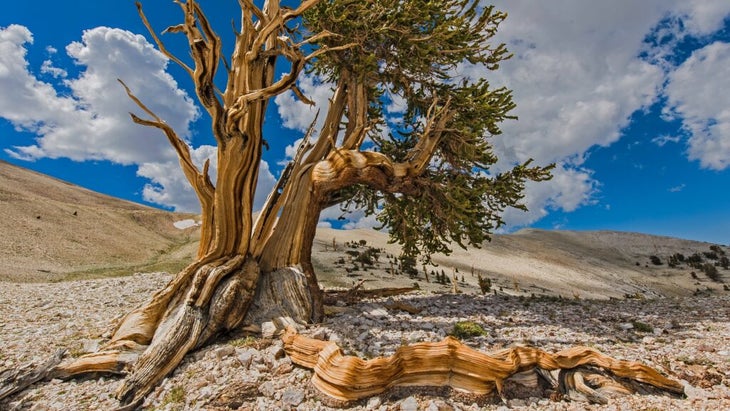
Location: Ancient Bristlecone Pine Forest
Mileage: 1 mile round trip
Access and Gaia GPS Route:
It’s a rare and special outing to hike among the oldest living things on earth, but this mile loop lets you do just that. After a drive along the winding, high-altitude road from the Sierra town of Big Pine into the White Mountains, park at the lot and get ready to have your mind blown.
Take your time and bring enough water to keep hydrated, as the trail begins at 10,000 feet. Many of the mature bristlecones along this path are over 3,000 years old—older than the original 13 American colonies or even the Roman Empire—and strolling among them always puts things into perspective for me.
2. Mesquite Flat Sand Dunes
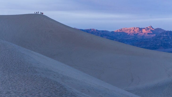
Location: Death Valley National Park
Mileage: 2 miles round trip
Access:
Although there’s no designated trail for this hike, this is a must-see California spot, with some of the most easily accessed sand dunes in the country. According to the National Park Service, it takes most hikers 90 minutes to get to and from the highest dune in the park, from which you can see the massive ridgelines of the arid Cottonwood and Panamint Mountains.
You’ll probably want to spend some extra time tumbling or sandboarding down the dune field, so set aside a half day to explore this Death Valley gem. Pro tip: go at sunset to witness the dunes and valley light up in a soft pink glow.
3. Congress Trail
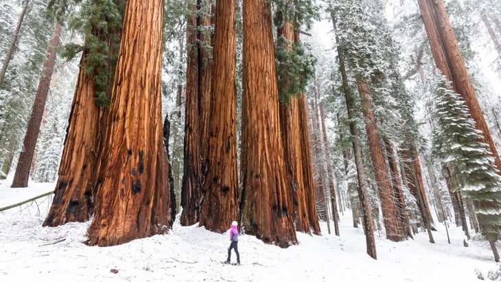
Location: Sequoia National Park
Mileage: 2.8 miles round trip
Access and Gaia GPS Route:
What’s a trip to Sequoia without a visit to the largest tree (by volume) on earth? Make that a priority, and after you’ve whispered your hellos to General Sherman, get away from the throngs of tourists on this accessible, paved path through a multitude of similarly impressive giant sequoias. Pine needles dampen the noise of others nearby, so you can truly unwind as you stroll past the enormous House and Senate Groups of trees. It’s a fantastic excuse to slowly saunter down a forested path, rather than hustle to the next crowded viewpoint.
4. Convict Lake Loop
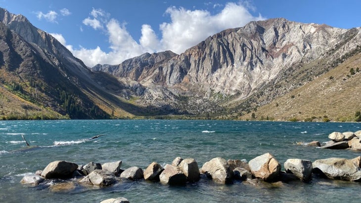
Location: Mammoth Lakes
Mileage: 2.8 miles
Access and��Gaia GPS Route:
This might just be the best easy hike in the whole state, and a stunning quarter-mile of it is paved and accessible to wheelchairs. Even the humble parking area has stupendous views of the toothy rock fins that jut out from the east face of 11,811-foot Laurel Mountain and the dark, imposing granite of 12,270-foot Mount Morrison.
Fishing for brown and rainbow trout is popular here (you’ll need a ), so you’ll likely see a few anglers out as you make your way around this mellow trail. After circumnavigating the glacially carved lake, from the neighboring marina or soak at the nearby Wild Willy’s Hot Springs.
5. Tall Trees Trail
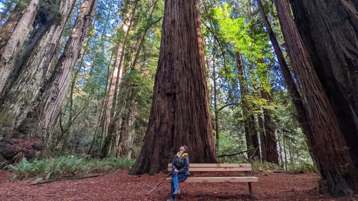
Location: Redwood National Park
Mileage: 3.5 miles round trip
Access and Gaia GPS Route:
If you’re a fan of old-growth forests, fantasy novels, or mossy green landscapes, this hike is for you. First, apply online for a that’ll get you a gate code to open the private, six-mile-long dirt road that leads to the trailhead. Don’t worry, my low-clearance, two-wheel-drive van made it just fine. After parking in a gravel lot shaded by conifers, you’ll step onto the trail and be transported to a scene straight out of Hobbiton. Maples and Douglas firs will occlude the bright sun as you descend steeply for 800 feet before coming to the beginning of the ancient redwood grove itself.
I highly recommend stopping at one of the benches at the center of the grove to close your eyes and meditate on the forest magic surrounding you before returning the way you came. If it’s a hot day, cool off in neighboring Redwood Creek before backtracking to your car.
6. Lassen Peak
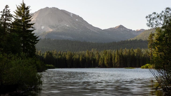
Location: Lassen Volcanic National Park
Mileage:��4.6 miles round trip
Access and Gaia GPS Route:
Want to summit a California volcano but don’t want to brave the glaciated slopes of Mount Shasta? Lassen Peak is a suitable, much easier plan B. Slap on your sunscreen before heading out, because Lassen’s slopes are incredibly exposed after the first mile, once you’ve emerged from the gnarled hemlock and whitebark pines. But the trade-off is worth it, with spectacular views the whole way up and down its switchbacks.
I enjoy the bird’s-eye view of Cinder Cone Volcano’s dark brown hump and the dacite lava domes of Chaos Crags as you scramble a leg-busting 1,957 feet to the summit. Take your time at the top and step off trail to descend into the interior of Lassen’s crater, which last erupted from 1914 to 1917.
7. Long Lake via Bishop Pass Trail
Location: Inyo National Forest
Mileage: 4.7 miles round trip
Access and Gaia GPS Route: Bishop Pass–South Lake Trailhead (see map below)
This is one of the best low-effort, high-reward day hikes or in the Sierra Nevada, namely because the trailhead is already located at a lofty 9,900 feet elevation, so your car can do much of the climbing for you. From the town of Bishop, head southwest and park in the lot near the South Lake boat launch, then hike south through a forest of ponderosa pines, taking in sweet views of 11-682-foot Chocolate Peak and 12,237-foot Hurd Peak along the way. Once you get to Long Lake, toothy 13,000-footers like Mount Goode and Mount Agassiz dominate the skyline.
If you’ve got an overnight trip planned, spend day two getting high above the tree line on the challenging switchbacks to Bishop Pass for a top-down look at the many cobalt blue lakes in the valley you just traversed.
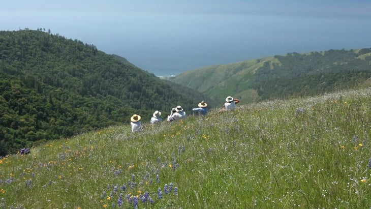
8. Condor Gulch to High Peaks Loop
Location: Pinnacles National Park
Mileage: 5.9 miles
Access and Gaia GPS Route:
One of our nation’s newest national parks, established in 2013, is only 55 miles southeast of Monterey. Haven’t yet visited? Make the most of it on this loop into the park’s High Peaks area for some of the best chances in the country of spotting an endangered California condor. From March through May, a psychedelic array of wildflowers blossoms across the park that include brilliant red fuchsia, orange poppies, and delicate yellow monkey flowers.
After a steep climb into the park’s namesake volcanic pinnacle formations, stop for a photo op and peer into the mountains of the Hain Wilderness before circling back toward the Bear Gulch Day Use Area. might want to tack an extra day onto their trip to explore the park’s many, many bolted and multi-pitch routes.
9. Lost Horse Mine Loop
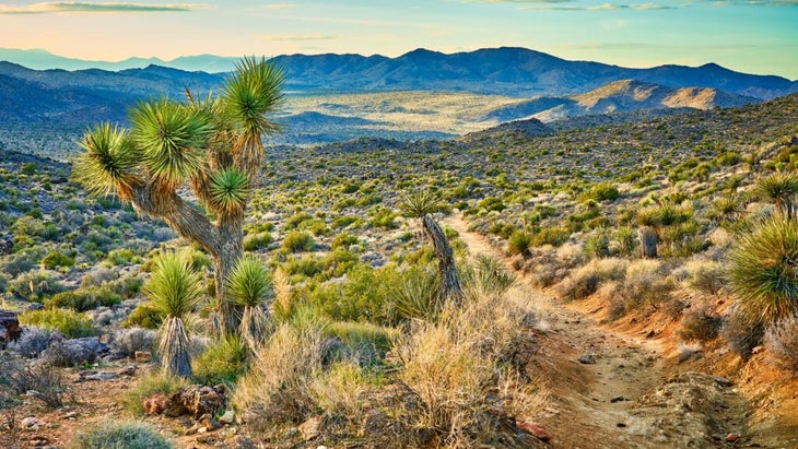
Location: Joshua Tree National Park
Mileage: 6.3 miles
Access and Gaia GPS Route:
This route rewards hikers with several payoffs, thanks to impressive Mojave Desert views, plenty of Seussian-like Joshua trees, and one of the in California. Centrally located in the park, near both Ryan Mountain and the Sheep Pass Campground, the trail meanders across the arid desert, passing numerous 19th-century stone ruins and the now defunct mine that once produced more than 10,000 ounces of gold and 16,000 ounces of silver in its heyday.
I suggest hiking the loop clockwise, to finish with views of thousands of the park’s namesake trees along Quail Wash.
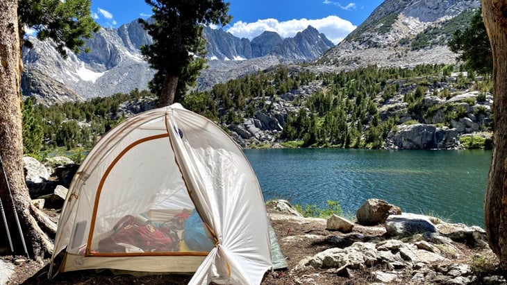
10. Little Lakes Valley to Gem Lakes
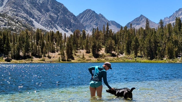
Location: in Inyo National Forest
Mileage: 7.2 miles round trip
Access and Gaia GPS Route: Little Lakes Valley Trailhead (see map below)
If you’re up for a hike to one of the most stunning valleys in the entire Sierra Nevada, plan to arrive at the designated parking lot along Rock Creek Road before 9 A.M. because this place is popular. The trail traipses along at about 10,200 feet elevation, making it a fantastic way to experience the high alpine without huffing and puffing up scree slopes.
From the lot, the trail heads south to a valley studded with shimmering, crystal clear tarns that call to hikers on warm summer days. Dip your toes in as many as you see fit, all while marveling at views of 13,000-footers like Mount Morgan and Mount Dade. If you can, grab a coveted for the area and spend the night at Gem Lakes, which is usually the turnaround point for day hikers.
11. Vicente Flat
Location: Big Sur
Mileage: 10.2 miles round trip
Access and Gaia GPS Route:
Featuring wide-ranging views of the cerulean blue ocean and coastal California redwoods, the thigh-burning trail up Vicente Flat is quintessentially Big Sur. Park off legendary Highway 1, right across from the Kirk Creek Campground, and get ready to ascend roughly 2,500 feet before reaching a large backcountry campground, shaded by old-growth redwood trees as thick as a truck. Turn around here, or pitch a tent and turn the journey into an overnight backpacking trek.
There is one thing to be aware of: poison oak–the area is full of it. So know how to identify and treat it.
12. Half Dome via the Mist Trail
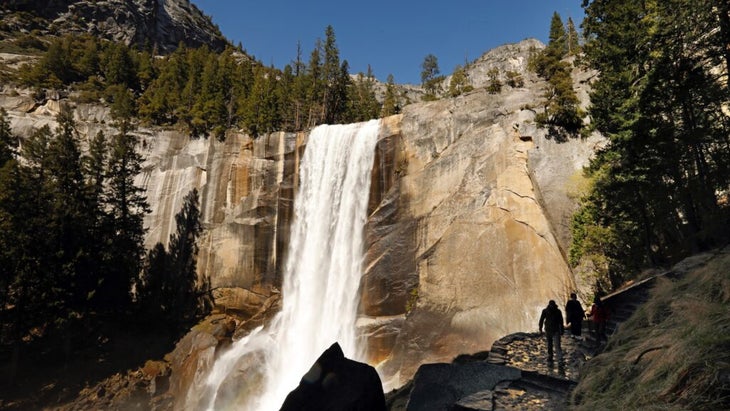
Location: Yosemite National Park
Mileage: 14 miles round trip
Access and Gaia GPS Route:
Looming large over Yosemite Valley, Half Dome’s immense granite facade is perhaps one of the most iconic natural landmarks in all California, with star billing given to it by Alex Honnold when he free-soloed it in 2008. Hikers will to trek this strenuous trail, and nabbing one is a highly competitive process that requires planning ahead and applying for the park’s preseason lottery during March, even if your hike isn’t until August.
The trail itself is absolutely out of this world though: you’ll stare slack-jawed at the roaring Nevada Falls and scale the slick back side of the 8,800-foot-high dome, gripping tightly to its Park Service–mounted cables as you ascend the final reaches toward the summit. Want to break up the 4,900 feet of elevation gain? Apply for an to backpack up to Little Yosemite Valley, stay the night, and then tag the summit at sunrise.
13. Cactus to Clouds
Location: Palm Springs
Mileage: 21 miles from the Palm Springs Art Museum to the peak to the Palm Springs Aerial Tramway
Access and Gaia GPS Route: Palm Springs Art Museum (see map below)
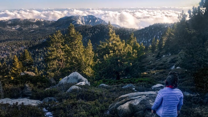
Cactus to Clouds is one of those outrageous, all-day challenges that looms large in the imaginations of serious California hikers. I’ve tackled its 10,819 vertical feet on two different occasions, and it remains one of the coolest trails I’ve ever completed because of the diverse array of biozones you get to pass through en route to the top of 10,834-foot Mount San Jacinto (the second highest peak in SoCal).
It’s best to sleep in Palm Springs and start your trek before dawn, to avoid high-afternoon temperatures. You’ll want to give yourself time to summit and then descend via the before calling a ride back to your vehicle.
An easier of the trek starts and ends at the tram station and still tags Mount San Jacinto, offering panoramic vistas of the myriad windmills of Palm Springs and conifer-speckled San Bernardino Mountains. One planning note: this trail can be temporarily closed when temperatures spike, so check out for updates.
Emily Pennington now hikes and writes about adventure travel from her home in Boulder, Colorado. Her 2023 book ��details her experiences visiting every park, including the nine spectacular units in California.��