şÚÁĎłÔąĎÍř

Padar Island, part of Indonesia’s Komodo National Park
(Photo: Eyes on Asia/Stocksy)
Padar Island, part of Indonesia’s Komodo National Park
Padar Island, part of Indonesia’s Komodo National Park (Photo: Eyes on Asia/Stocksy)

These 15 Beaches Will Blow Your Mind


Published:  Updated: 

Our farthest-roaming travel writer reveals her favorite stretches of sand, from a sheltered cove in Greece to a stunning outpost in North Carolina. Which looks best to you?


New perk: Easily find new routes and hidden gems, upcoming running events, and more near you. Your weekly Local Running Newsletter has everything you need to lace up! .

Nothing says vacation like a beach. But sand alone does not a great beach make. I want a peaceful place to soak up the sun but also prefer destinations where I can surf, swim, kayak, and hike to take in an incredible view. In my two decades as a travel writer, I’ve seen my fair share of gorgeous beaches, but none of them have struck me as much as these. Each is worth the journey to get there.

These are my picks for the 15 most beautiful beaches in the world.

Lençóis Maranhenses National Park, Brazil

Lençóis Maranhenses National Park
Lençóis Maranhenses National Park is home to some of South America’s biggest dunes. (Photo: Guido Cozzi/Getty)

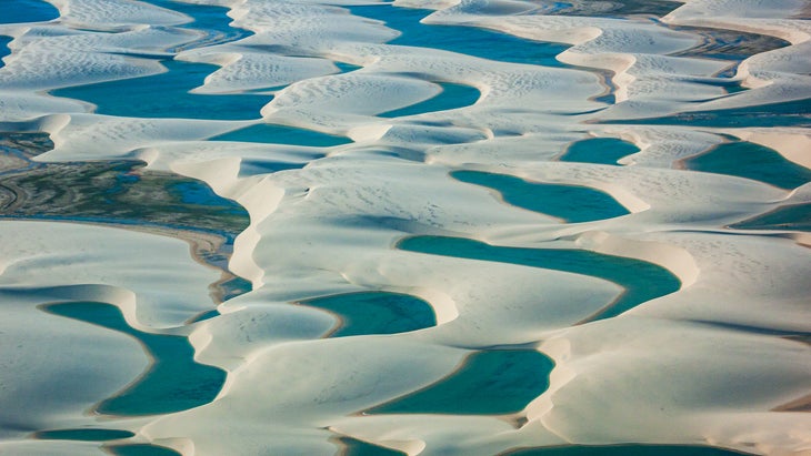
Why it’s tops: When it comes to beaches, Brazil has an embarrassment of riches. But none can compare with Lençóis Maranhenses, a mirage-like landscape of cerulean lagoons hidden among 30-to-60-foot-high dunes the color of pearls. These freshwater pools are fullest between June and September, after the austral spring’s rains, and the unique ecosystem is home to endangered species like the scarlet ibis and neotropical otter. You can explore the park on foot or with a dune buggy, but a horseback-riding safari with is the best approach, because you can choose a slow pace while still delving miles into the dunes.

How to get there: This 43-mile stretch of coast in northeastern Brazil is truly off the beaten path. First you’ll wing into São Luís (a three-plus-hour flight from São Paulo or Rio de Janeiro), then drive four hours east to the gateway town of Santo Amaro do Maranhão. Or head to the village of Atins, located at the mouth of the Preguiças River; the area is a popular kitesurfing spot from July to December.

Where to stay: Some of the tallest dunes are found on the west side of the park, easily accessed from Santo Amaro, which is sprinkled with inns like (from $45) and newcomer (from $580). In Atins, ($330) is a hip hotel.

What to bring: The sand can be scorching, so pack water sandals. And Atins has no ATM, so have cash or a credit card handy.

Locals at Carova Beach
These locals at Carova Beach enjoy the water just as much as humans, and can sometimes be seen playing in the surf. (Photo: Hayden Pennington)

Carova Beach, Outer Banks, North Carolina

Why it’s tops: In the summertime, tourists descend upon the Outer Banks, a string of barrier islands home to Cape Hatteras, the nation’s first national seashore, and Kitty Hawk, where the Wright brothers made their historic first flight. If you want to escape the masses, venture to Carova, which is roughly 11 miles long and two miles wide. Some travelers come for the seclusion, others to explore the 4,570-acre Currituck National Wildlife Refuge, with an eye out for endangered loggerhead turtles, 300-plus species of birds, and a celebrity herd of wild colonial mustangs 112 strong. Take note, though: you should cruise to Carova only with a four-wheel-drive vehicle; you don’t want to get stuck in the sand or incoming tides (or both). If you’d rather put someone else behind the wheel, outfitters like Corolla Outback şÚÁĎłÔąĎÍřs and Hummer şÚÁĎłÔąĎÍř Tours offer guided trips in open-air safari vehicles. Or if you’re interested in road-tripping up the Atlantic this summer, check out our list of the wildest East Coast beaches.

How to get there: When Highway 12 ends, you’ll begin driving on the beach. Deflate your tires to 20 psi for better traction.

Where to stay: Camping isn’t allowed on Carova, but there are plenty of vacation rentals, many of which can be booked at bargain prices after Labor Day (from $120).

What to bring: A full tank of gas—Corolla has a filling station—a tire gauge, and a tow strap in case you get stuck. Plan to park on the beach between April and October for the day? Purchase in advance ($50).

Wineglass Bay
Wineglass Bay sees its share of birdlife, from cormorants and pelicans to sea eagles and black swans, so bring your binoculars. (Photo: Nick Rains/Getty)

Wineglass Bay Beach, Tasmania, Australia

Why it’s tops: Tasmania’s most photographed beach can be reached only on foot or by boat, so I imagined having it to myself when, approaching the end of summer, I set off on the 3.7-mile (round-trip) at dawn. How naive I was. The bay’s arc of white sand is considered the jewel of Freycinet National Park, the 40,000-acre wilderness home to nearly 50 endemic animal species, many worthy of a Dr. Seuss book (look up the red-necked wallaby and the spiky echidna). I also didn’t realize that March is one of the island’s busiest months (October and November are far quieter). Some say that the bay was named for its curved shape, but according to history books the moniker originated from the red hue the waters took on in the island’s whaling days. During my visit, the climb to the bay’s lookout, less than a mile from the trailhead, was jammed. Most visitors ogle the now turquoise bay and its backdrop of pink-tinged granite peaks from here, but to touch sand and sea you’ll have to descend some thousand stairs. Trust me, the quad-burning effort is worth it: the quiet, mile-long shorefront feels worlds away from the tourists above.

How to get there: From the Tasmanian capital of Hobart, drive 120 miles up the east coast to the seaside village of Coles Bay, which abuts the national park.

Where to stay: Camping is free in the park at Wineglass Bay and at Hazards and Cooks Beaches. Or treat yourself to a stay at (from $154), one of the few accommodations within the park and just 1.5 miles from the Wineglass Bay Trailhead.

What to bring: Drinking water is scarce in the park, so fill your bottles at the visitor center or the parking lot near the trailhead.

Playa Espadilla
The golden sands of Playa Espadilla make this a popular beach with locals and tourists alike. Keep an eye out for signs about riptides and currents. (Photo: Adam Barker/Tandem)

Playa Espadilla, Costa Rica

Why it’s tops: This wide, mile-long beach just outside the town of Quepos is my idea of sandy perfection. Rainforest tumbles down to the Pacific; at low tide it’s a dream to run on the firm sand; and because it’s west facing, it delivers some of the prettiest sunsets I’ve ever seen. The northern half of the beach is public, while the southern half is within Manuel Antonio National Park. (To access the rest of the park, for $18.) May through November there are daily sprinkles, and you can spot migrating humpback whales and turtle hatchlings making their way into the water.

How to get there: From San José’s international airport, it’s a two-and-a-half-hour drive south or a 30-minute connecting flight to Quepos via Aerobell or Sansa Airlines. The drive from Quepos to the resort and beach takes about 15 minutes.

Where to stay: Splurge on a stay at (from $520), a sustainable, community-minded resort set on an 11-acre, trail-laced private nature reserve. A ten-minute walk from the property, a short trail unfurls to the north end of the beach, and the resort’s team of naturalists took me on nature walks to point out sloths and fiery-billed aracaris.

What to bring: Surf’s up May through November, so bring your board or rent one from the beachfront .

Drakes Bay at Limantour Beach
Elephant seals, sand dollars, and magnificent scenery are just a few reasons visitors are drawn to Limantour Beach at Drakes Bay. (Photo: Kirkikis/Getty)

Limantour Beach, Point Reyes National Seashore, California

Why it’s tops: When I lived in San Francisco, Limantour was my weekend respite from the city’s cool, foggy summers. Midway up Drakes Bay, it extends four miles from the west end of Limantour Spit southeast to Santa Maria Beach. Sometimes I’d go at low tide so I could run the hard-packed sand. In spring, I’d hike the wildflower-lined trails—a favorite was the , where bush lupine and Indian paintbrush bloom—then flop on the shore and scan the horizon for spouting gray whales migrating with their calves. I’m pretty sure harbor seals and shorebirds outnumber people, no matter the season.

How to get there: From San Francisco, take U.S. 1 up to Olema and the national seashore before continuing on Limantour Road for 7.5 miles to reach the parking area.

Where to stay: The park’s campsites are booked months in advance. If you can’t score a reservation, the hotels and Airbnbs in Olema are pricey but charming. For eats, I often concluded my visits with barbecued oysters and a Dungeness crab roll from Nick’s Cove, a 40-minute detour north on Highway 1 that also has waterfront cabins and hillside cottages (from $350).

What to bring: Coastal microclimates are unpredictable, and Point Reyes is always windy, so layer up.

Jobson’s Cove
Jobson’s Cove is intimate enough to have to yourself if you get there at the right time. (Photo: Marc Guitard/Getty)
The terrace restaurant at Bermuda’s Reefs Resort and Club
The terrace restaurant at Bermuda’s Reefs Resort and Club has an enviable view. (Photo: Courtesy The Reefs Resort and Club)

Jobson’s Cove, Bermuda

Why it’s tops: Jobson’s Cove is a mini version of nearby tourist darling Horseshoe Bay. Both are blanketed by blush-colored sand, and both boast calm, crystalline waters sheltered by jagged limestone and lava-rock cliffs. While Horseshoe Bay has seasonal lifeguards, umbrella rentals, and a snack stand, Jobson’s Cove lacks those amenities but makes up for them with quiet seclusion. Its small size gives it the feel of a private swimming hole stocked with tropical fish. If you’re brave, climb the steps carved into the beach’s high, rocky outcrops to take in the endless south-shore view—there’s almost nothing between here and Antarctica.

How to get there: A short trail connects Horseshoe Bay to Warwick Long Bay. From Horseshoe Bay’s parking lot, it’s about a 0.8-mile stroll to Jobson’s Cove.

Where to stay: Travelers willing to brave the brisk waters of shoulder season (March to April and October to November) are rewarded with hotel deals. I like the family-operated, oceanfront , just a five-minute drive from Jobson’s Cove (from $228).

What to bring: Snorkeling gear to spot the resident midnight parrotfish and large porgy.

Pink sand, the effects of a microorganism, on Pantai Merah, Indonesia
The pink sand on Pantai Merah, Indonesia, is an effect of a microorganism. (Photo: kitzcorner/ Getty)

Pink Beach, Komodo National Park, Indonesia

Why it’s tops: Komodo’s gargantuan namesake dragons may be the star attraction of this national park. But a close second is Pantai Merah, otherwise known as Pink Beach, on Padar Island. One of just a handful of pink-sand beaches on the planet, it stands out for its dramatic setting, sandwiched between electric-blue waters and a Jurassic Park–grade backdrop of savannas and peaks that are vibrantly green from April to June, following the rainy season. Make the 20-minute trek to the island’s highest point and your awe will only grow, courtesy of the panoramic views: crescent-shaped coves outlined in pink, black, and white sand. (You decide which is most Insta-worthy.) Komodo dragons are believed to be extinct on Padar, but the coral-filled waters teem with marine life, including green sea turtles, manta rays, and six species of shark.

How to get there: From Bali, it’s an hour flight to Komodo International Airport, on the western side of Flores Island. From nearby Labuan Bajo, boats make the three-to-four-hour trip southwest to Padar Island. Want to get there faster? Opt for an 80-minute speedboat ride with , which also offers guided excursions to the national park’s 50 dive sites.

Where to stay: There are no lodgings on Padar Island, but the resort in Labuan Bajo is a short drive from the dock where you’ll hop your interisland transportation (from $230). Most people like to explore the archipelago by boat. ’ seven-night Komodo National Park itineraries have private landing sites and exclusive trekking routes at Pink Beach and other popular spots (from $9,415).

What to bring: Sturdy sneakers, a hat, and plenty of reef-safe sunscreen are all mandatory.

Cala Brandinchi
The calm, protected waters of Cala Brandinchi make this a family-friendly cove. (Photo: Will Salkeld)
Lunch is served at the Vesper Beach Club in Capriccioli, Sardinia
Lunch is served at the Vesper Beach Club in Capriccioli, Sardinia. (Photo: Will Salkeld)

Cala Brandinchi, Sardinia, Italy

Why it’s tops: With fine quartz sand and jewel-blue waters, this inlet lives up to its nickname, Little Tahiti. You’re more likely to see pine forests than palm trees here, however. Brandinchi’s beauty has made it such a social media sensation that an was introduced, limiting daily visitors to 1,500 between June and September ($2). Visit in fall, though, and it’s quiet enough to hear the soundtrack of cicadas. Kiosks sell snacks and spritzes and rent out paddleboards for what turns out to be the ideal activity in the calm, shallow waters. It’s hard to pull your eyes from the sparkling sea, but take a break and wander to the nearby pond, a habitat for herons, flamingos, and the black-winged stilts.

How to get there: Fly into Olbia Costa Smeralda Airport, Sardinia’s northern hub. From there catch a bus or cab, or rent a car, and head 20 minutes south to San Teodoro, a town just 15 minutes from Cala Brandinchi. Between June and September, a bus connects San Teodoro to the local beaches, running six times a day; $16 will get you an all-day pass. Or rent a bike in town and pedal to the beach.

Where to stay: (from $10) has waterfront sites, a restaurant, and bike and scooter rentals. For a wider array of amenities, , near Tavolara Marine Reserve, is just ten minutes by car from the beach (from $375).

What to bring: Non-EU visitors wanting to rent a car will need an international driving permit.

The dunes of Sandwich Harbour
The dramatic dunes of Sandwich Harbour drop right into the ocean, a wild, colorful landscape seen few places in the world. (Photo: Marco Bottigelli/Getty)

Sandwich Harbour, Namibia

Why it’s tops: One of the most exhilarating adventures of my life was sand-skiing the mountainous, garnet-colored dunes near Sandwich Harbour, straight down to the flamingo-dotted ocean’s edge. The excursion was part of a weeklong camping safari in the heart of Namib-Naukluft, Africa’s largest national park, although the operator hasn’t offered it since because of logistical challenges. But the Mars-like landscape is easily accessed by a 4×4 or an ATV from Walvis Bay, a port town 35 miles north. Departures must be timed to the tides, and even the best drivers struggle to navigate dunes that soar upwards of 200 feet, so it’s wise to join a guided tour with a company like . Then you can focus your attention on the extraordinary desert and any wildlife that crosses your path, be it jackal or seal. Up for a good hard walk? Climb 1,256-foot Dune 7, east of Walvis Bay; it’s one of the world’s tallest.

How to get there: Walvis Bay, the country’s third largest city, is a convenient base for a DIY trip or one guided by locals. You can fly direct from both Cape Town and Johannesburg.

Where to stay: If you’re a birder, stay at the (from $80). It overlooks one of the continent’s richest protected wetlands, known to host hundreds of thousands of avian species, including flamingos. For a larger-scale trip throughout Namibia, consider a . I’ve been to its owner-operated camps in South Africa, and they truly put conservation first.

What to bring: Binoculars, a hat, and a scarf or tall neck gaiter will protect your face from the sun and wind-whipped sand.

Matala village and Messara Bay
The village of Matala (population 300) overlooks Messara Bay, Crete. (Photo: Wilhelmina Van Rijn E/V Andeweg/Getty)
Agiofarago, sheltered by cliffs and rocks
Agiofarago, sheltered by cliffs and rocks, is largely exposed, so expect to tote in any supplies, including sufficient water. (Photo: lucianbolca/Getty)

Agiofarago Beach, Crete, Greece

Why it’s tops: A friend once told me that Greece is meant for island-hopping. After a visit to Crete, I’m inclined to disagree. The fifth largest island in the Mediterranean isn’t a stopover; it deserves a week minimum to appreciate the ancient ruins, mountain trails and gorges, and, yep, hidden beaches. My favorite was Agiofarago. The name, which translates to Gorge of the Saints, recalls a time when monks solemnly lived in its surrounding caves. Off the tourist path, on Crete’s sleepier south coast, the beach’s smooth-pebble shore can be reached by hired boat from the towns of Matala, Agia Galini, and Kali Limenes. But the easy walk in via its eponymous gorge is a unique experience. After 45 minutes, you’re facing crystal waters begging you to dive in. Vertical cliffs and rocky nooks provide shade even in July. Don’t be surprised if you see an ascetic or two meditating on the rocks; many still make pilgrimages.

How to get there: From the hippie seaside town of Matala, drive ten minutes northeast to the village of Sivas, then south until you reach the Odigìtria Monastery. Take a left on the dirt road toward Kali Limenes. After 2.5 miles, you’ll see a sign for the parking lot; the gorge path begins there.

Where to stay: The seafront , in the village of Agia Galini, is an hour northeast (from $70). I chose to stay two hours north in the mountains at Kapsaliana Village Hotel, a historic stone building surrounding an olive mill (from $120).

What to bring: Sport sandals and plenty of water.

Playa Carrizalillo, Mexico
Playa Carrizalillo, Mexico, is a vibe. (Photo: Spacewalk/Getty)

Playa Carrizalillo, Puerto Escondido, Mexico

Why it’s tops: Over the years, Puerto Escondido has evolved from a sleepy fishing village to a surfing mecca, and it’s now also a boho-chic enclave for artists and influencers. If you want laid-back vibes, you’ll find them at Playa Carrizalillo. This half-moon-shaped shorefront is merely a 15-minute walk from the bustling downtown but feels miles away. One of the area’s six beaches, it’s often bypassed because visitors must descend (and eventually reascend) 157 steep stairs. But at the bottom, palapas where freshly caught fish are sold dot this slice of paradise. Unlike the pounding, experts-only barrels of nearby Playa Zicatela, the left-hand surf break here is super mellow and perfect for beginners and longboarders. After a dawn session, refuel on chilaquiles at , perched above the beach—or visit at day’s end for a mezcal-spiked sundowner. The restaurant is run by the owners of Fidencio Spirits.

How to get there: From Puerto Escondido’s airport, a ten-minute drive east puts you at the beach.

Where to stay: , 45 minutes outside town in quiet Villa de Tututepec de Melchor Ocampo (from $424). The low-key setting, the excellent tacos and tostadas, and a 160-foot pool overlooking the ocean make the drive worthwhile.

What to bring: Big-wave season is April through October. Bring your nine-footer.

Little Beach at Makena Beach State Park
Little Beach at Makena Beach State Park is considered one of the more laid-back hangouts on Maui. It’s clothing-optional. (Photo: Travis Morrin Photography)

Makena Beach State Park, Maui

Why it’s tops: Maui’s windswept north shore is my home part of every year, and when I need a staycation, I head south to spend a day at . A stark and refreshing contrast to the manicured, resort-lined shores of neighboring Wailea, Makena remains undeveloped. Nearly two-thirds of a mile long and 100 feet wide, it’s locally referred to as Big Beach. Even when the parking lots are full (nonresidents pay a $10 fee per vehicle), you can still find empty sand, especially if you’re willing to walk. Puu Olai, a cinder cone, separates Big Beach from Little Beach, a nudist haven. For spectacular views of the islets Molokini and Kahoolawe, it’s a steep but short climb up the only trail from the beach to the top. Big Beach is patrolled by lifeguards, but be warned: the shore break is fierce, so you should only bodysurf or boogie-board there if you’re experienced.

How to get there: From Wailea, Makena State Park is a ten-minute drive south on Makena Alanui Road. There are two parking lots just beyond the beach entrances. If you’re visiting on a weekend, arrive early.

Where to stay: While Wailea is essentially a strip of pricey beachfront resorts, Hale Kukuna, a new cultural center at the , helps justify the hefty price tag (from $1,109). , in neighboring Kihei, is a more affordable alternative (from $247).

What to bring: There’s not much shade, so pack a beach umbrella. If you don’t bring lunch, order tacos from the Jawz food truck near the first parking lot.

Crystalline ice and black sand at Diamond Beach
Crystalline ice and black sand make Diamond Beach one of the most stunning in Iceland. (Photo: Ivan Haidutski/Stocksy)

Diamond Beach, Iceland

Why it’s tops: If Antarctica and the Island of Hawaii had a baby, it would look like Breidamerkursandur. Virtually impossible for non-Icelanders to pronounce properly, this spectacular collision of volcanic and glacial landscapes has kindly been nicknamed Diamond Beach by locals. Its obsidian sands are scattered with brilliant chunks of ice that glisten like gems—an even more magical sight in the soft light of dawn and dusk. For the ultimate photo op, visit between September and May to catch the green and violet rays of the northern lights reflecting on the shorefront icebergs.

How to get there: From ReykjavĂ­k, drive five hours east on Route 1, otherwise known as Ring Road.

Where to stay: Given the time from the capital and all the points worth stopping for en route, I suggest staying the night at ($166), set on Route 1 between Skaftafell National Park (famous for its waterfall) and Jökulsárlón Glacier Lagoon.

What to bring: Warm and waterproof or water-resistant clothing.

Sandwood Bay
Sandwood Bay is what you might expect of a Scottish beach: wild, windswept, and wonderfully brisk much of the year. (Photo: Jack Anstey)

Sandwood Bay, Scotland

Why it’s tops: One of the most remote, unspoiled beaches in all of the UK, Sandwood Bay is a place for contemplation. Just five miles from the mainland’s northwesternmost tip—Cape Wrath—and reached via a fairly flat but boggy seven-mile path across the Highland moors, Sandwood beckons a hardy kind of traveler. Conditions are frequently windy and cold, and even in August, which is the warmest month, high temperatures are in the low sixties. The beach spans the coast for 1.5 miles and is flanked by cliffs and dunes; its south end is guarded by the imposing sea stack of , which draws seasoned climbers. Spring is when I’d visit, when the North Sea is still wild—a dramatic sight before it calms in summer. A brisk dip may seem tempting after the two-hour trek, but the currents are strong, the water is cold, and swimming isn’t advisable. If you’re looking for something a little less DIY, the outfitter  can arrange multi-day hiking or biking adventures in the area.

How to get there: It’s a 95-mile drive from Inverness to Kinlochbervie, a loch-surrounded hamlet with few services. Drive west past town three more miles and park at the lot just before the road runs out; the is maintained by the John Muir Trust (make a donation before setting off).

Where to stay: The town of Durness, 18 miles from Kinlochbervie, has several options, including , with tweed furnishings, homemade organic breakfasts, and a parlor where you can sip on something strong to take off the chill (from $220).

What to bring: Repellent to fight off the midges, hiking or trail shoes, and a picnic lunch.

Sotavento beach
In Sotavento, which means “leeward,” wind-powered water sports are the preferred way to pass the time. (Photo: Pavel Mora/Getty)

Sotavento, Canary Islands

Why it’s tops: Sotavento is a catchall for 15 miles of five epic white-sand beaches, running from Playa Barca in the north to Morro Jable in the south, on the island of Fuerteventura. All are part of . The name of its gateway town, Costa Calma, is a bit of a misnomer, as this shoreline is famed for its winds. Every summer, world-championship events for windsurfing, kitesurfing, and wingfoiling are held here, and throughout the year neon sails soar above the surf. At high tide, the beach turns into a maze of sandbanks and shallow lagoons ideal for swimming and mastering the basics of wind sports. Clothing at the beach is optional, but nudists take heed: wind-blown sand ends up everywhere.

Where to stay: Meliá Fuerteventura, the area’s top resort, is undergoing a renovation, but its renowned wind-sports school, run by local waterman , is still open for lessons. The adults-only sister property, , is a great alternative (from $244).

How to get there: From the Fuerteventura airport, it’s an hour drive south on FV-2 to Sotavento.

What to bring: Stock up on water in Costa Calma, and pick up some delicious El Almendro almond candies, a real treat.


Author Jen Murphy on the beach
The author on a recent trip to Costa Rica (Photo: Courtesy Jen Murphy)

şÚÁĎłÔąĎÍř contributor Jen Murphy was born and raised on the Jersey Shore. She’s happiest with sandy feet and salt-kissed skin.