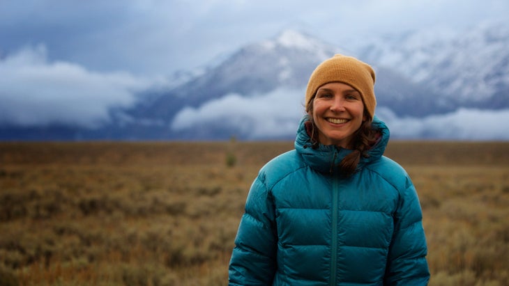
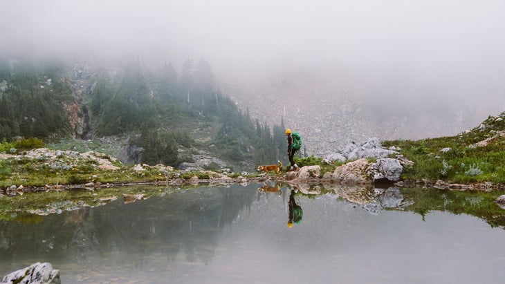
I’ve tackled sections of the Pacific Crest Trail—backpacking, day hiking, and trail running—but to think of taking months off to complete all 2,650 miles of this trail, which climbs mountain passes and traverses remote California, Oregon, and Washington, feels overwhelming. A long-distance walk, on the other hand, feels more manageable, like something any of us could pull off, given some time. They mostly involve days and weeks rather than many months, and are at more consistent elevations.
I’m not talking about a mountainous thru-hike where you plan out food caches and sleep on the ground. I’m talking about a meandering or purposeful walk that goes on for days, weeks, or maybe months. A big commitment, yes. A physical feat for sure. A mental and emotional pilgrimage of sorts. But not so strenuous that most people couldn’t do it, building up their mileage.
These long walks, on byways and moderate terrain, are more like scenic tours of spectacular landscapes, or adventurous journeys through cities and forests. They are not so much to be completed as experienced.
And I think they’re the most beautiful in the world.
1. Best Urban Trail
Empire State Trail, New York
It took four years to link up and complete the entire , one of the longest multi-sport pathways in the United States, officially finished in late 2020. The route runs 750 miles across the state of New York, from New York City north to the Canadian border and from Albany west to Buffalo. Three quarters of the trail is on off-road pathways. You can walk on converted rail trails through the Hudson River Valley, stroll beside the historic Erie Canal, or move through wetlands and fields along Adirondack Park and Lake Champlain. Eventually the trail will include a 200-mile greenway across Long Island; construction of the first 25 miles of that section begins this year.

Pick a section of this largely urban route, which is also popular with bicyclists, and walk it one direction, then hop on a train back to where you started—Amtrak stations are located in 20 towns and cities along the way. Find community with others traveling the trail or seek tips on good trailside lodging or camping from .
Don’t Miss:�� ��More than 200 craft breweries dot the Empire State Trail, in an aggregate known as the . Get a brewery passport and pick up stamps at the places along the way to earn rewards like a T-shirt or cooler bag. In the Hudson Valley, spend a night at (from $195), which has cabins, canvas tents, and a cedar sauna just a short walk from the trail.
����
2. Best Pilgrimage
El Camino de Santiago, Spain
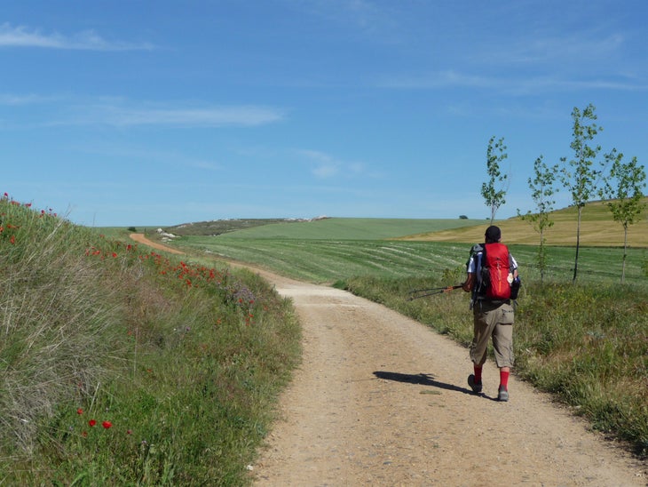
Each year, over 300,000 people embark upon sections of this legendary pilgrimage, on a network of trails dating back to pre-medieval times and roadways that vary from cobbled to paved. The most popular route is the Camino Frances, a 500-mile pathway that starts in St. Jean Pied de Port, France, and takes travelers about four to five weeks to walk, passing through the Pyrenees mountains and La Rioja wine region, La Meseta arid range, and through eucalyptus forests into Galicia and Santiago itself. The Camino Portugues, heading up the northern coast of Portugal is another top choice, stretching between 140 and 380 miles depending on your starting point, and crossing through fishing villages such as the UNESCO Heritage Listed cities of Lisbon and Porto. No matter which route you choose, all roads��on the Camino lead to the cathedral of Santiago de Compostela in northern Spain, where the remains of the Apostle Saint James the Great are allegedly buried.
You can walk the Camino year-round—the most popular season is mid-summer—but aim for spring or fall for mild temperatures and fewer crowds, and be aware that many lodges and albergues close in winter ). offers guided walks on the Camino through Portugal and Spain lasting from a week up to 22 days (from $1,436), or, if you’d rather go on your own, has self-guided options (from $718).
Don’t Miss: Once you reach Santiago de Compostela, head to the Pilgrim’s Office for your official stamp of completion, having received a pilgrim’s passport from your entry point to be stamped along the way. Bagpipes will be playing nearby as you enter the gates of the holy Santiago de Compostela.��The cathedral has a Pilgrim’s Mass at noon and 7:30 p.m. daily; go early if you want a seat. On , await the ancient ritual of the swinging brass Botafumeiro, or cauldron, which is filled with incense and coal and so heavy eight men are required to move it.
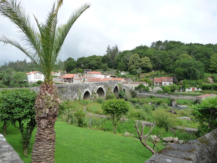
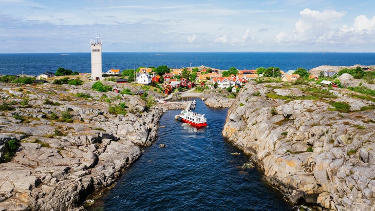
3. Best Waterfront Route
Stockholm Archipelago Trail, Sweden

Opening in October 2023, the 167-mile connects new and existing pathways across 20 islands in the Stockholm Archipelago, the largest archipelago in Sweden and home to over 30,000 islands. To walk the whole thing, you’ll need to use a series of public ferries and private boat taxis. You can also pick a section and just walk a few islands at a time; each has an average of about nine miles of trails. You’ll travel along gravel roads, forest paths, and beaches, and through remote fishing and farming communities.
Along the way, camp or stay in hotels or B&Bs. offers a seven-day, self-guided journey on the trail (from $1,095) in spring, summer, or fall that includes lodging in locally owned hotels, luggage transfer, and daily routes that max out at about nine miles.
Don’t Miss: On the island of Tranholmen, a celebrated chef named David Enmark opens up his home to diners every Friday night—. Or visit the island of Furusund, which contains about five miles of trail and is site of a famed 19th-century summer resort, now a 16-room boutique hotel: the (rooms from $121), which welcomes guests who arrive by boat or on foot.
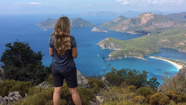
4. Best for History Buffs
Lycian Way, Turkey
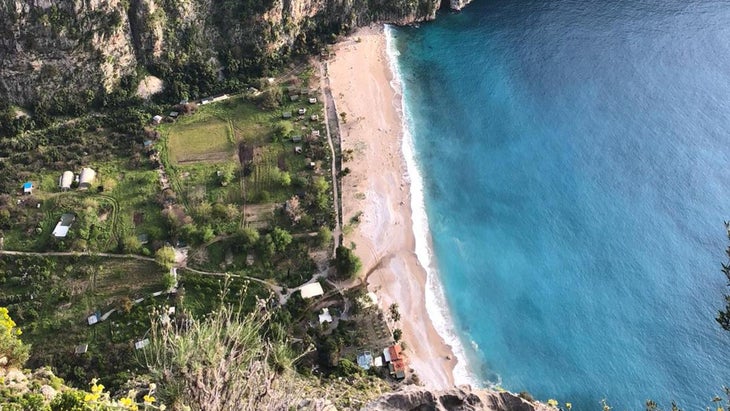
Traversing the rocky Mediterranean coast of southwestern Turkey, the 472-mile Lycian Way winds through the ancient maritime republic known as Lycia. Mountains rise from the turquoise sea as the route follows old roads, footpaths, and mule trails through long-gone civilizations. You’ll pass by lighthouses, beaches, historic sites like Roman amphitheaters and rock tombs, and lagoons over underwater ruins of sunken cities that can be toured by boat.
Most people take on just a section of the Lycian Way. has five- to 14-day guided tours (from $1,187) that include lodging and luggage transfer, or leads seven-day treks (from $995) with an English-speaking guide. Best to do this historical walk in spring or fall, from February to May or from September to November to avoid the high heat of summer.
Don’t Miss: �ճܰ�����’s illuminates Lycia’s ancient capital city of Patara after dusk, making it a magical place to explore by night. Best lodging on the trail: the (from $240), built in 2005 on a hillside, has glass windows, viewing hammocks, and saunas overlooking the Aegean Sea.
5. Best for Conservationists
John Muir Way, Scotland
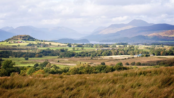
Not to be confused with California’s more demanding John Muir Trail, the is a relatively new route (established around 10 years ago) that stretches coast to coast across Muir’s home country of Scotland. This 134-mile walk begins in the western waterfront town of Helensburgh, where quotes from the famed Scottish-American environmentalist mark a commemorative stone bench. The trek ends around 10 days later in the eastern seaside town of Dunbar, where Muir was born in 1838.
On the way, you’ll walk through the cobbled streets of the capital city of Edinburgh, along the shores of , and by the Falkirk Wheel, a rotating boat lift in central Scotland. has self-guided itineraries (from $1,827) for the entire route, including accommodations.
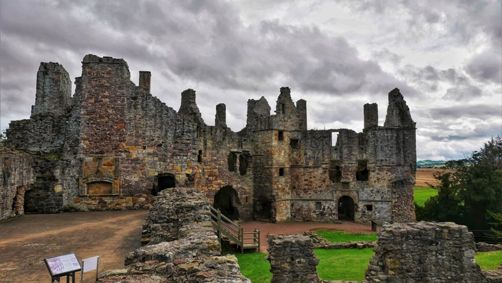
Don’t Miss: Stay in (from $417), a restored 16th-century castle��just off the trail 20 miles east of Edinburgh. The trail’s eastern terminus is at Muir’s birthplace, a humble three-story home in Dunbar that’s now a historic and free to visit.
6. Best for Self-Reflection
Shikoku Pilgrimage, Japan
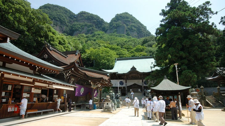
This circular walk across the Japanese island of Shikoku visits 88 temples and sacred sites where the Buddhist saint known as Kūkai is thought to have trained in the 9th century. The entire route is about 745 miles—mostly using roads, but also on select mountain trails—and takes around six weeks to walk. Or you can choose just a section.
The traditional approach starts at the first temple, Ryōzenji, in Tokushima prefecture and proceeds clockwise until you reach the last temple, Ōkuboji, in Kagawa prefecture. Many pilgrims dress in traditional attire, including a white cotton robe, scarf, and straw hat, and carrying a walking stick; they also carry pilgrims’ books, to be stamped after worshipping at each temple. leads an eight-day tour of the pilgrimage (from $2,303), where you’ll walk up to eight miles daily with an English-speaking guide, staying at guesthouses and temple lodging.
Don’t Miss: One of the hardest temples to reach is number 21, Tairyuji, or Temple of the Great Dragon. You can ride the tram to reach this mountaintop temple or hike to the site on a steep three-mile trail through limestone rocks and an ancient cedar forest. There you’ll climb a marble staircase leading into the temple gates and visit a bronze statue of Kūkai meditating.
7. Best for Wildlife Spotting
Yuraygir Coastal Walk, Australia

The 42-mile point-to-point leads through the beaches and bluffs of Yuraygir National Park in New South Wales. You’ll start in the village of Angourie and follow the sign-posted track, as trails are called in Australia and New Zealand, south to the red-tinted cliffs of Red Rock. Most people take four to five days to do the whole route. Along the way, you’ll spot turtles and whales, swim in the Pacific Ocean, and walk through coastal headlands and the biodiverse Solitary Islands Marine Park.
Spend your first night on the trail camping at the , which is only accessible on foot. Or if you’d prefer sleeping in a bed, book a guided walk that includes shuttles to trailside properties like (from $234) or (from $125). leads a guided five-day walk of the trail (prices vary according to group size and season) for private groups from November to April that includes luggage delivery, boat and bus transfers, national-park fees, and accommodations. If you’d rather go it on your own, you can base out of the family-owned in Wooli, and the owners will arrange for lifts to the trail each day (from $499, including lodging and hiker shuttles).
Don’t Miss: Stop into the beachfront , about halfway through your route, for a sausage roll or pizza. Spend some time at the and estuary, a breeding site for endangered shorebirds including the pied oystercatcher and beach stone-curlew. The trail along the Station Creek estuary is lined with scribbly gum and corkwood trees, and if you’re lucky, you’ll spot an Australian crane or coastal emu.
8. Most Adventurous
Te Araroa, New Zealand
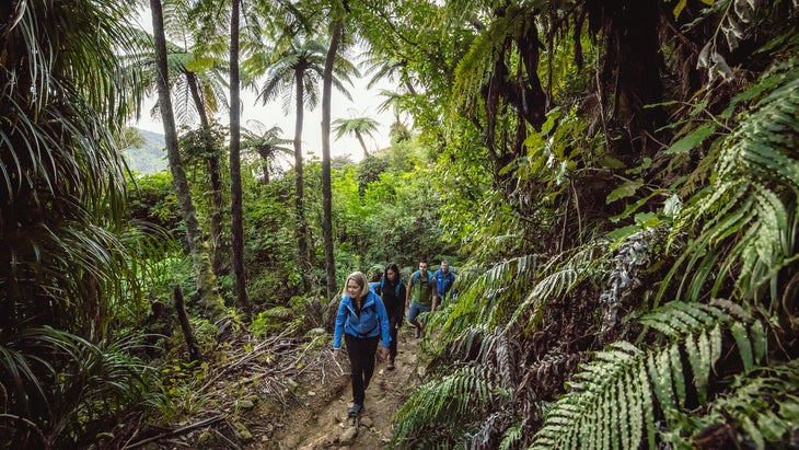
New Zealand is known for its stellar tracks, and , also called the Long Pathway, is the country’s most ambitious trail project yet. It’s a 1,900-mile journey crossing the length of New Zealand’s North and South Islands, from Cape Reinga at the north end to Bluff at the southern tip. The trail itself climbs mountain passes, crosses verdant plains, and travels through small cities and remote villages. Roughly 2,000 people walk the whole trail each year, taking between three and six months. Most hikers go north to south, starting around October, which is springtime in New Zealand. If you don’t have that kind of time, pick a section or a single island; the South Island is considered the more challenging of the two due to its more mountainous terrain.
While this video shows a Te Araroa thru-hike, some choose a section or decide to hike either the North Island or South Island. The South Island is more remote and considered more difficult, the North Island route longer but with more road walking. (Video: ���ϳԹ��� TV) ��
Before you go, ($34) to receive the latest maps and a Te Araroa walker-information packet. Buy a (from $110) for access to over 70 Department of Conservation-managed backcountry huts and campsites along Te Araroa. The trail also has ��to help you plan and navigate, and the trail notes for each section give details on the route and where to stay and resupply. Or you can book a guided 12-day trip with (from $8,595) and let the outfit take care of the logistics, including hotel bookings.
Don’t Miss: On the North Island, you’ll climb the extinct volcano of Mount Pirongia and descend to the valley below, where you’ll walk by the glowworm-studded , which are worth a stop; you can see the illuminating glowworms in their grottos by boat. On the South Island, spend a night at the 12-bunk, first-come, first-served near Wanaka, which has stunning views from the porch overlooking the Motatapu Valley and a nice swimming hole in the adjacent creek.
9. Best Way to Explore Indigenous Cultures
Vancouver Island Trail, Canada
Vancouver Island, British Columbia, is a rugged and densely forested place, and the 500-mile is among the most challenging routes on this list. The trail goes from the capital city of Victoria on the southern end of the island to Cape Scott on the northern tip, crossing rocky beaches and through lush rainforests and territories sacred to First Nations tribes, including the Songhees in the south and the Tlatlasikwala to the north. The trail is broken up into seven distinct sections, from paved pathways through urban areas to logging roads, hiking trails, and rail trails. Each section takes around five to 10 days to walk—or you can spend two months doing a complete thru-hike. Some sections of the trail are still being completed and not well marked, so plan on some skilled route finding or that’s better delineated. If you’re walking the trail northbound, you’ll end in , where the Cape Scott Lighthouse has been shining light for mariners since 1960.����
Don’t Miss: Book a cabin or pitch a tent at the First Nations-owned , between the northern towns of Port McNeill and Port Hardy. At the center of Vancouver Island, you’ll walk through Strathcona Provincial Park, British Columbia’s oldest park, dotted with high-alpine lakes and jagged snow-capped peaks. The , on the outskirts of the park, has eight seasonal campsites and a sauna.
10. Best New Trail
Camino de Costa Rica, Costa Rica
You’ll walk from the shores of the Atlantic Ocean to the beaches of the Pacific Ocean on the 174-mile-long , or the Costa Rican Way, which was inspired by Spain’s El Camino de Santiago. This relatively new trail—established in 2018 by the nonprofit Asociación Mar a Mar—travels through coffee plantations and rainforests, over the Continental Divide, and among tiny villages that rarely see tourists. Plan on around 16 days to hike the whole thing.
The trip starts on the Caribbean coast of Costa Rica, in the town of Barra de Parismina, at the base of Tortuguero National Park, known as a nesting ground for leatherback turtles. It ends in Quepos near Manuel Antonio National Park, filled with coral reefs and white-sand beaches. Stay in guesthouses, campsites, and hotels along the way. You will want to hire a guide, as much of the trail is sparsely marked. leads guided hikes ranging from eight to 16 days (from $1,675) that include meals and stays at local homes and guesthouses.
Don’t Miss: In the Orosi Valley, stay at the (from $59), which has private casitas and rooms close to the trail. In the town of Orosi, you can visit Iglesia de San José Orosi, the oldest church in Costa Rica, dating back to 1743, and its Religious Art Museum, and the .
11. Best Paved Trail
Paul Bunyan State Trail, Minnesota
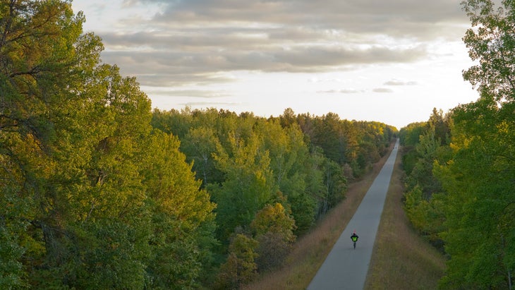
Most popular with cyclists, the Paul Bunyan State Trail is still a great long walk for those who want a paved, accessible pathway. The route begins at in Brainerd and ends 115 miles later at in Bemidji, home to a famous giant statue of Paul Bunyan and his Blue Ox, Babe. This is the longest continuously paved rail-trail in the country, moderate in grade throughout as it follows the former Burlington Northern Railroad, abandoned in 1983. You can camp at and Lake , or stay in hotels in the various trail towns along the way.
Don’t Miss: You’ll walk through the town of Hackensack, where every September chainsaw carvers turn hunks of wood into art in the annual Chainsaw Event. The (from $89) in the town of Nisswa has rooms and lakefront cottages steps from the trail on Lower Cullen Lake. In Pequot Lakes, stop into the trailside for a scoop of ice cream.
12. Best for Foodies
Cinque Terra, Italy
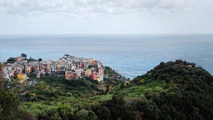
Cinque Terre or “Five Lands” refers to five coastal towns—Monterosso, Vernazza, Corniglia, Manarola, and Riomaggiore—over the the Ligurian Sea, all linked by about 75 miles of hiking trails. The most popular route is the Sentiero Azzurro, known as the Blue Trail, which is less than 10 miles and can be done in a day. You can start in Monterosso or Riomaggiore and work your way in either direction, passing through lemon groves and walking staircases directly down to the sea.
For a more expanded tour, consider five- or eight-day self-guided hiking trips in Cinque Terre, where you’ll stay in curated hotels, dine on pizza and gelato from locals’ favorite spots, and ride trains to reach new trails each day. If you’re hiking on your own, be sure to check the for updates on closures (landslides have closed sections of the trail), and grab a (from $7 a day) for access to the two paid hiking trails—from Monterosso to Vernazza and from Vernazza to Corniglia—and for use of the bus lines within Cinque Terre National Park.
Don’t Miss: Climb the stairs to Doria Castle, a medieval fortress near the village of Vernazza, to see the remains of one of the oldest surviving towers on the Liguria coast. The five-room guesthouse (from $208) in the Unesco World Heritage Site of Vernazza makes for a good midway stop on your hike.
13. Most Accessible
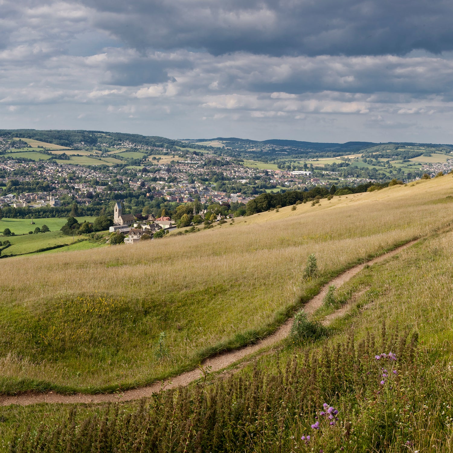
Cotswold Way, England
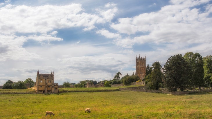
The is a quintessentially English experience, where you’ll walk from the historic market town of Chipping Campden, once a busy center for traders, to the steps of the Late Medieval church of Bath Abbey, crossing through farmlands, country parks, and beech woodlands. Stop and admire fields full of sculptures or study English Civil War sites. This well-marked 102-mile trail can be traveled in either direction, taking between seven and 10 days. has both guided and self-guided walks (from $1,154) ranging from between seven and 12 nights, where you’ll sleep in limestone cottages and guesthouses.
Don’t Miss: Climb the hill to the Broadway Tower, an 18th century tower within a 200-acre estate of parkland offering expansive views across the valley; enjoy afternoon tea at the Tower Barn Café afterward. The trail also passes by , home to some 30 species of endangered butterflies, and , a historic garden filled with seasonal flowers and a lavish mix of Classical, Gothic, and other architecture.
Megan Michelson is an ���ϳԹ��� contributing editor and avid traveler who once lived in England for a year and went on a lot of long rambles through the countryside. She recently wrote about trips that may help you live longer and her favorite new backcountry hut in Colorado.