

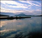
My sodden boots are sliding on the heather-and-mud slope. My hiking companions, their voices muffled, are only yards distant. That much I know. But wrapped in a milky fog, I have next to no idea where I’m going or, for a disorienting moment, whether I’m staring up or down. Suddenly the mist shreds, unveiling a view of the tranquil landscape 2,000 feet below: a glacier-carved valley, grass-green and potholed with scores of lakes that gleam like beads of spilled quicksilver. I stop to gape, picking out whitewashed cottages and woolly knots of grazing sheep until, just as quickly as they dissolved, the clouds recoagulate.

In case I’d forgotten where I was clambering, the evanescent panorama succinctly reminds me that I’m footloose in the Back of Beyond—a local nickname for Connemara, the wild region that comprises the northwest chunk of County Galway and the heart of the ancient province of Connaught. The last piece of Ireland to enter the modern age, Connemara did so reluctantly and incompletely. The Irish language is still alive here; many residents watch Teltilifis na Gaeilge, a two-year-old Gaelic TV station. And a reverence for the siog (SHEE-owg), or spirit world, remains a part of everyday life. William Butler Yeats, who summered here and is buried in nearby Sligo, had the West’s proud, melancholic isolation in mind when he wrote about Connemara in “The Phases of the Moon”: “Too lonely for the traffic of the world: / Body and soul cast out and cast away; / Beyond the visible world.”
Indeed, until a century or so ago many Irish regarded this hinterland as the ends of the earth, legendarily populated by bog-trotting simpletons and quick-witted rascals who eked by on subsistence farming and fishing, along with a brisk trade in smuggled goods, bootleg whiskey, and wreck salvage. The impression had its roots in the hard times following Oliver Cromwell’s rapacious invasion of 1652. To the Catholic gentry, Cromwell offered two options: “To Hell or Connaught!” Nearly 200 years later, Connemara was savaged by potato famines, during which thousands starved or emigrated.
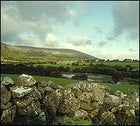
But in more recent times, it has become clear that exile from the mainstream has, in some ways, served Connemara well. This remains one of Ireland’s most sparsely populated and starkly beautiful regions, with its black-brown stretches of peat bog and humpbacked mountains; rock-walled pastures and trout-filled loughs; and barrier islands inhabited by seagulls, gray seals, and a handful of humans. During several visits, I’ve ventured farther and farther out from the neat, bayside capital of Clifden to experience the spell cast by the countryside’s elemental textures of cloud, bog, stone, sand, soil, and water. And in the past decade I’ve watched a steadily growing influx of travelers—Irish, French, German, and American—do likewise, exploring the Back of Beyond’s more remote reaches via foot, bicycle, horseback, and sea kayak.
While no virgin wilderness—this is the British Isles after all—Connemara is much less trafficked than the southwestern counties of Cork and Kerry. The Gulf Stream keeps the climate mild, but the elements can still present challenges: It rains more than 250 days a year, and the wind blows almost constantly off the Atlantic. Try to schedule your visit between May and September, and always pack good raingear, boots, and a reliable compass. But come: Intense, unfeigning Connemara is the closest you’ll get to what Ireland once was.
: Ireland’s Connemara
Trekking around Clifden
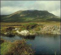
Driving up the Inagh Valley is not the most efficient way to cover the 40 westerly miles from Galway to Clifden, but it’s my favorite approach, cutting spectacularly through Connemara’s stony heart. To the east lie the Maumturk Mountains, a fine, flat-summited range, but I always find myself looking west, up into the purplish brown, distinct peaks of the Twelve Bens, mirrored by the narrow boomerang-shaped Lough Inagh. Despite topping out at a relatively diminutive 2,400 feet, the Bens—deforested, like most of Ireland, centuries ago—manage to loom impressively. They encircle the busy, Georgian-style town of Clifden with an ancient presence that is part Catskills, part northern Pacific Coast.
The Bens, traditionally the realm of wandering blackfaced sheep, are now regularly traversed by hikers, a feat not always as simple as it might appear. After fortifying yourself with a fried breakfast of staggering proportions at your B&B in Clifden, the most convenient base for a Connemara vacation, head five miles northeast to Letterfrack, a three-pub crossroads at the edge of Connemara National Park. Composed mostly of bogs cleverly camouflaged by grass and wildflowers, the 3,800-acre park (admission, $3) is an excellent introduction to this classic Irish terrain, whose main constituent, peat, is still cut and dried, then burned in local hearths that issue blue, sweet-scented smoke. You can bone up on turf ecology at the visitors center (learning, for instance, that peat is actually densely compacted sphagnum moss on its aeon-consuming way to becoming coal), then embark on a short nature walk, or farther south, up into the Bens themselves. Alternatively, you can set out from Gleann Clochan, 17 miles east of Clifden on Highway N59, where a ten-mile, full-day circuit boasts more than 5,000 feet of ascents and expansive views of the Maumturks; get detailed directions at the Ben Lettery Youth Hostel, behind which the trek begins.
A few trekking tips: Wear socks and pants that you don’t mind sullying, perhaps irrevocably. To prevent erosion, stick to trails; to avoid getting lost in the often-dense fog, take a map or a guide. And stay alert for patches of quaking bog, hypersaturated muck that can swallow you to the waist.
Or do as I did this past spring and will certainly do on return trips: Call Michael Gibbons’s Walking Ireland (011-353-95-21379), a trekking outfit run by a Clifden native who is a passionate and unrivaled expert on local archaeology. At 40, the boyish and bespectacled Gibbons is not only an excellent shanachie, or storyteller, but also a Connemaran version of Indiana Jones, able to pick a deft line across steep rock faces while pointing out ancient sites that he’s found: Bronze Age tombs, Iron Age forts, and standing stones (quartzite pillars that probably marked Neolithic ceremonial sites).
For Gibbons, history is only a squint away; tag along on one of his day-treks ($21) and you’ll never look at a peat bog the same way again. “The bogs protect the richest archaeological landscape in Europe,” he told me as we surveyed the pointed perimeter stones of a megalithic tomb. Rocky soil and strong ties to the spirit world, he explained, discouraged Irish farmers from emulating their continental counterparts, who tilled every scrap of arable land. For millennia, the bogs rose a foot every 500 years, swallowing all they encountered. Gibbons’s finds often result from tips by farmers who have hit something while cutting peat. “They’re exposing an earlier landscape preserved absolutely perfectly underneath,” he says, his voice echoing the conviction that Connemara’s truest treasures lie beneath her surface.
: Ireland’s Connemara
Cycling the Coast
Connemara’s soggy soil tends to discourage off-road biking. Luckily, the lightly trafficked roads that wind through its valleys and along its deeply indented coast offer some of the most ruggedly picturesque cycling in Ireland. South of Clifden you’ll find wide, sandy beaches and the quiet resort town of Roundstone. Up north lie Cleggan and Claddaghduff, jumping-off points for Inishbofin and Omey Island, as well as Killary Harbor, Ireland’s only fjord.
There are three things to know before pedaling. Rather primitive road engineering renders inclines good and steep. The prevailing west-coast winds blow south to north; if you’re planning a longer tour, ride with and not against these indefatigable breezes. And be sure to stop by the Clifden Bookshop or Gibbons’s office to buy Ordnance Map 37 ($6), which shows everything from public phones to historic sites. You can rent a mountain bike ($10 per day) at Mannion’s on Bridge Street in Clifden. For multiday trips, consider bringing your own bike, or at least a helmet, panniers, and clipless pedals and shoes. Killary Tours, based eight miles north of Clifden in Renvyle, can help arrange luggage transport and accommodations for a self-guided trip or hook you up with a guided group.
If you have only one day for cycling, spend it on Sky Road, a classic 16-mile loop around a narrow, bluff-lined peninsula west of Clifden. Starting in front of the Hotel Alcock & Brown, you’ll climb past the ruins of Clifden Castle, a mock-ancestral manse built by town founder John D’Arcy around 1818, and turn left two miles later to reach a hilly lump called Ardmore Point. Look across the inlet to see Mrs. Roche’s house, the last continuously inhabited thatch cottage on the peninsula. Farther west spreads a protected harbor where, in 1947, a farmer found a fully intact skeleton clad in Viking armor. Wandering the fields and beaches are Connemara ponies, whose ancestry is said to include stallions that swam ashore from wrecked Spanish Armada galleons. (For $20 an hour you can ride one; call the Cleggan Riding Centre at 011-353-95-44746.) Continuing the loop back toward Clifden, be sure to stroll the beach near the Dereen bridge in Streamstown; the spring beneath your step comes from an underlying (and safe) expanse of quaking bog.
If you have the time or the inclination to try a more challenging itinerary, your best bet is Renvyle-based Little Killary ���ϳԹ��� Centre, which can equip you for everything from Hobie Cat sailing and windsurfing to rock climbing, scuba diving, and sea kayaking. Despite the blustery coast’s allure, kayaking remains relatively novel here; intrigued paddlers should contact Killary Tours guide Jon Hynes, who will gladly help you plan a trip or lead your group on a weeklong foray that includes camping on uninhabited islands, fishing, and pulling up on beaches strategically chosen for their proximity to pubs.
: Ireland’s Connemara
Wild Winds, Rough Going, No Blarney: Ireland’s Connemara: Exploring the Islands
Connemarans have always lived intimately with the ocean—the Irish phrase Con na Mara means “tribe of the sea”—and nowhere is this bond more evident than on the region’s tiny barrier islands. The most accessible, thanks to a hard-packed beach that links it to the shore at low tide—is Omey Island, a quarter-mile off Claddaghduff. Omey’s claim to fame is that in the seventh century it was home to St. Feihin, one of those culture-conserving clerics celebrated in Thomas Cahill’s 1995 best-seller, How the Irish Saved Civilization. But it’s the island’s strand, which reappears every four hours, that exerts the magical pull; during a two-week stay, my family returned half a dozen times to watch the sea ebb and flow, or to walk to the island. You can also drive—but mind the tide. Get stuck midway and you might experience the recurring Miracle of Omey: As the tide is about to engulf your car, a tractor appears. You smile and reach for your wallet; the driver smiles and uncoils his winch line.
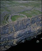
A more tranquil island experience awaits visitors to Inishbofin. Attracting far fewer tourists than the heavily visited Aran Islands to the south, windswept Inishbofin (population 200) lies nine miles out from Cleggan, a tiny port six miles north of Clifden. After a 30-minute ferry ride ($16 round-trip), Inishbofin greets you sternly. Looming over its harbor is a star-shaped fort built in the 1650s by Cromwell’s troops, who used the island as an open-air prison for Catholic priests. You can walk a healthy stretch of Inishbofin’s 16-mile circumference in a day. But if you’ve got the time, stay overnight and let the slow rhythms of sun, tides, and ferry schedule make you feel like an islander. There are a few good pubs and B&Bs, as well as the friendly and popular Inishbofin Island Hostel, which offers dorm bunks, private rooms, and camping.
Inishbofin Cycle Hire rents bikes ($10 per day), but most explore on foot, following the shoreside path east from the pier. About a mile in, a stone ring between two ridges marks the remnants of a Stone Age roundhouse. Three-quarters of a mile farther is a ruined, famine-era village. And on the west coast, you’ll find sea-carved caves and blowholes, a colony of gray seals that are especially numerous during September’s mating season, and perhaps a corncrake, a near-extinct indigenous bird with an unmistakable “crek-crek” call. To walk the edge of the Back of Beyond is to meditate on loneliness and connection, as I did this Easter, which the unrelenting Atlantic celebrated with a squall that caught me out on Inishbofin’s flank. No matter which way I turned, I had wind and rain in my face. As time passed, though, the pummeling felt almost familiar, an echo of ancestral experience. By the time I shambled into the crowd at Murray’s Pub to drain my boots and a few pints beside the hearth, I understood, better than I had before, how isolated one can feel in Connemara, and yet also how at home.
: Ireland’s Connemara
Behind the Back of Beyond: Getting Down to Earth ont he Magical Edge of Eire
On the Connemara calendar, rain is never far away, but during July and August the sun shines often and long, setting after 9 p.m. The catch: While generally warmer, summer months boast a temperature range (45 degrees to 75 degrees) nearly as wide as the rest of the year. In any season, pack waterproof outerwear, fleece, and spare boots. And before you leave, visit your library to copy local tide tables from MacMillan Nautical Almanac 1999. You’ll need them, trust me.
Getting There:
During summer, round-trip flights to Shannon International on Aer Lingus (800-223-6537) cost $748 from New York and just $698 from Los Angeles, if you fly between August 15 and 30. Rates drop by nearly 50 percent come November. You can book Avis rentals through Aer Lingus; a midsize car runs $280 per week.
Lodging:
In Clifden, base yourself at the new Dun Ri Guesthouse (doubles, $35; 011-353-95-2162, dunri@anu.ie), a comfortable, centrally located spot that serves up vast breakfasts. The best place to indulge your country-squire fantasies is the Killary Lodge (doubles, $78¡$100; 011-353-95-42276), a restored nineteenth-century fishing retreat on the wooded shores of Killary Harbor, 20 miles north.
Outfitters:
For a trek that will exercise your imagination as much as your quads, contact archaeologist Michael Gibbons, at Walking Ireland (011-353-95-21379; walkwest@indigo.ie; office shown at left). Inside his compound near Clifden, you can buy maps and books, eat, and even bunk (doubles, $28). In Renvyle, Little Killary ���ϳԹ��� Centre (011-353-95-43411) rents mountain bikes ($8 per day) and offers daylong activities ranging from canoeing to orienteering. Affiliated Killary Tours (011-353-95-42276) will arrange longer trips, whether cycling, hiking, sea-kayaking, horseback riding, or diving; eight-day itineraries start at $655. Stanley’s on Market Street sells freshwater fishing licenses ($7 per day) and indispensable hand-knit wool socks ($17).
Readings:
Local son Joss Lynam provides essential information about 18 Connemara treks—from where to park to where to catch the best views—in The Mountains of Connemara: A Hill-Walker’s Guide (Folding Landscapes, $4). Cartography buffs will also want to invest $20 in Connemara Map and Gazetteer, Tim Robinson’s superbly rendered topographical portrait (Folding Landscapes). For a quick but thorough education on Back of Beyond culture, try Hidden Connemara (Connemara West, $7), a compilation of writings on regional archaeology, history, and folklore, edited by Erin Gibbons.