

David Hardy stops and says calmly, “There he is.” I look at a spot I’ve already looked at twice, and there, indeed, he is—a very large black-tailed rattlesnake, coiled in perfect camouflage less than three feet from our boots. A miniature radio transmitter implanted in the snake’s body has led us right to him, and yet the handsome olive and chestnut pattern on his back enables him to disappear into the leaf litter like a Marine sniper. Fortunately, like all rattlesnakes, this one’s only aim is to escape detection, so he continues to lie immobile next to the faint wood-rat trail along which his next meal is likely to come. We step gingerly aside, and Hardy, a retired anesthesiologist whose avocation is studying rattlesnakes, takes notes on location, time, and temperature.
This snake is one of 41 that Hardy has radio-tagged over the last 11 years, and those 41 snakes are but a fraction of the thousands of animals lugging around some sort of ID within the Chiricahua Mountains, a range of 9,000-foot peaks tucked into the southeastern corner of Arizona. Birds, mammals, reptiles, amphibians, fish, insects—name a species, and someone is likely studying it. Researchers come from around the world, employing the latest technology in radio collars, radio implants, “passive integrated transmitter” tags, ear tags, even tiny bar codes cemented to butterfly wings and hummingbird leg bands that would be a snug fit around a pencil lead. A common sight from my backyard in Cave Creek Canyon is an intent scientist waving what appears to be a high-gain television antenna, probing for the signal from some wayward subject. An innocent visitor might think we were living in some sort of nefarious biological police state.
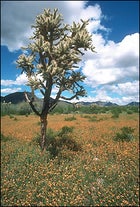
The reason for this intense scientific scrutiny is simple: The 1,000-square-mile Chiricahua Mountains represent an ecological crossroads of unparalleled diversity. Four major North American bio-regions converge here, two of them deserts (the Sonoran and the Chihuahuan) and two of them mountain chains (the Rockies and the Sierra Madre). The result is a biotic stew stunning in both numbers and contrast. Consider: Of the 700-odd species of birds that regularly occur in the United States, over half can be found in this area. Within a 20-mile drive from the base of the Chiricahuas to the top, you rise from cactus and thorn scrub to Douglas fir and Engelmann spruce—the equivalent of a trip from Mexico to Canada.
Bring Marlon Perkins along on that drive and it’s doubtful he could narrate fast enough to describe its wild kingdom. Black bears and peregrine falcons rule the high country, while coyotes and roadrunners—sans explosive Acme apparatus—prowl the flats. Just east of the range, rancher and hunting guide Warner Glenn photographed a jaguar in 1996, and residents of Cave Creek Canyon have reported glimpses of jaguarundis—black, house-cat-size felines indigenous to tropical Mexico.
The United States blew its first chance to preserve these mountains more than 100 years ago. Cochise, the leader of the Chiricahua Apaches, for which the mountain range is named, negotiated a reservation that included the entire range, but after his death the treaty was summarily trashed, and Cochise’s people were herded to distant reservations. Had the United States kept its bargain, it would have avoided the considerable trouble caused by a later Chiricahua leader named Geronimo.
Today the mountains are protected to varying degrees. There’s a 12,160-acre national monument and an 87,700-acre wilderness area, while the rest is primarily Forest Service land. It’s all still wild, however, and not a destination for the high-adrenaline outdoor-sports crowd. There’s not a ski area within 200 miles, most of the rock is too crumbly for climbing, and anyone in a hang glider would probably be captured and radio-tagged by an overzealous grad student.
You’ll be mostly on your own when you visit. There are few inns, fewer restaurants, and fewer gas stations still. Instead there are miles of uncrowded trails, offering some of the most diverse wildlife viewing anywhere in the world. Bring a good pair of binoculars and every field guide you can find—you’ll need them all.
Chiricahua National Monument
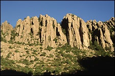
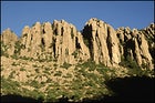
The geology of the Chiricahuas is as striking as the biology. Twenty-seven million years ago, a massive volcanic explosion (known to geologists by the disarming French term nuĂ©e ardente, “glowing cloud”) blew 100 cubic miles of lava, ash, and rock into the atmosphere—about 1,000 times more material than Mount St. Helens ejected in 1980. The fallout covered the nearby landscape to a depth of up to a half-mile and left a crater 12 miles wide. Subsequent erosion of the compacted rhyolite has created a wonderland of spires and balanced boulders in Chiricahua National Monument, 30 miles south of Willcox, at the northwestern corner of the range. It was this maze of rock that allowed Cochise to make fools of the U.S. Army until the government accepted peace on his terms.
There’s a visitors center here with the usual exhibits, but you won’t spend much time inside. The pink, gray, and lichen-green stone columns, like the disordered rows of a giant’s chess set, lead you up and away. Take the eight-mile drive to Massai Point for an overview and then walk the seven-mile route through the Heart of Rocks. You’ll lose the casual sightseers and experience (with considerably less stress) the disorientation felt by the soldiers who long ago anticipated ambush behind every boulder. As you thread between ever more improbable formations, corny snapshots of friends “holding up” huge rocks prove nearly irresistible. Keep an eye out for coatis, agile mammals that resemble stretched-out raccoons. The slender, striped lizards you might spot are Chihuahuan whiptails, which are all female and reproduce by parthenogenesis, effectively cloning themselves.
Near the monument entrance on Arizona 181, the 24-mile Pinery Canyon Road leads up and over the range, giving easy access to Cave Creek Canyon on the east side. For a stout 50-mile bike loop, leave your car at the monument entrance and ride up the road to 8,800 feet at Barfoot Park (“park” being local terminology for open meadows), then head back down the Pine Canyon jeep trail. The fir-trees-to-prickly-pear descent is quite a finger workout; V-brakes could not be more highly recommended.
Cave Creek Canyon

I remember my wife’s expression as we sat in front of several hummingbird feeders in downtown Portal, at the mouth of Cave Creek Canyon. Two blue-throated hummers, fighting for dominance, aimed straight at her face doing 30 miles per hour and then cut at the last second, one right and one left, within inches of her ears. She cringed and then whooped with glee. Meanwhile at least 30 more were engaged in their own fierce battles, zinging around us in tight loops and banked turns.
If the idea of flying 2,000 miles to see a bird called a plain-capped starthroat seems odd to you, you haven’t spent much time in Cave Creek Canyon. This is one of the nation’s top destinations (along with south Texas and Cape May, New Jersey) for power birders, those fanatic few who book last-minute flights to catch a glimpse of a blue mockingbird or an Aztec thrush. These are common birds in Mexico, but occasional dalliance across an imaginary political line lends them star status here.
But you don’t have to have a 700-species life list—in fact, you don’t even have to be a “birder”—to appreciate the avian show, particularly during the migration peak in May. In the white-barked sycamore trees along the creek, elegant trogons, members of the tropical quetzal family, hoot like sound effects in a Tarzan movie. Hummingbirds, over a dozen species, put on vertiginous displays of aerial acrobatics. Backyard tallies of species run higher here than in entire states. And it all happens beneath spectacular rhyolite cliffs that tower 2,000 feet over the canyon.
Portal, the tiny (population 80-ish) hamlet at the canyon’s mouth, boasts a small store and the Portal Cafe, which serves up solid American fare. The Portal Peak Lodge, behind the store, rents tidy doubles for $65 (520-558-2223). Farther up the canyon, straddling the small stream, Cave Creek Ranch has apartments and cottages, all with kitchens (doubles, $60-$100; 520-558-2334). The managers/naturalists (full disclosure: my wife and myself) lead free birding and natural history walks. Nearby, three Forest Service campgrounds provide water and toilets ($6 per night). Be sure to stop by the American Museum of Natural History’s Southwest Research Station, the hub of scientific inquiry for the Chiricahuas. The office staff will know what projects are underway, and you can supplement your burgeoning field-guide collection at the gift shop.
The Chiricahua Wilderness
Biologists call the mountain ranges that tower over the Arizona deserts “sky islands,” a reference to the plants and animals that survive on their cool, rainy slopes, isolated by surrounding heat and dryness. Nowhere is this effect more clear than when you stand shaded by firs and pines on 9,795-foot Chiricahua Peak and look west toward stark Willcox Playa, an enormous bone-dry lakebed.
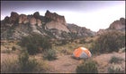
About 200 miles of Forest Service trails crisscross the Chiricahua high country. Late spring brings perfect weather for exploring them—usually. (I was once left tentbound for four days on top of the range by a freak April snowstorm that closed I-10, 5,000 feet below me.) The trail system lets hikers customize a nearly endless selection of routes. One of my favorite two-day backpacking loops starts in Cave Creek Canyon on the five-mile Greenhouse Trail, which switchbacks up past the impressive Winn Falls to a high open meadow at Cima Park, where there are several good unimproved campsites (camping is allowed anywhere in the high country). From here, it’s only 1.5 miles to Chiricahua Peak. Head south along the ridgeline on the Crest Trail, which occasionally opens up with expansive views. Turn left at the junction with the South Fork Trail, which descends back to Cave Creek (17 miles total). Black bears are fairly common in this area, so cook and store food away from your tent. Water is reliable in spring if there’s enough snowmelt, but it should be treated.
For a high-country day hike and a lesson in fire ecology, drive up Pinery Canyon Road to Rustler Park and take the Crest Trail to 9,666-foot Flys Peak. It’s six miles round-trip; if you’re up to it, make a 13-mile loop by connecting with the Saulsbury and Rock Creek Trails. In 1994, the Rattlesnake Fire burned 27,000 acres of this forest, and the rejuvenation is amazing to see. Use caution, however—snags and limbs still fall occasionally.
From different parts of the trail, I can not only view all four of the Chiricahua’s biotic regions; I can see and feel and smell the connections between them. The ash from mountain fires drifts down and fertilizes desert cactus, and the hot wind that sweeps across the valleys cools as it rises up the range, dropping rain on the pine seedlings shouldering their way up through old, dead needles. The Chiricahuas are my answer to those who think all the last best places—the Serengeti, the Galápagos—are a world away. This American place forms its own biological paradigm.
Up at Dawn? Too Late: Tricks to Navigating Arizona’s Wildest Outposts
Getting There: The Chiricahuas are hidden in Arizona’s southeastern corner, a stone’s throw from New Mexico and not far from old Mexico. The most convenient launching place for a Chiricahuas trip is Tucson; America West flies there from LA for $115 roundtrip, and from New York for about $400. Once there, rent a car from Dollar (800-800-4000), starting at $145 a week. A 4WD isn’t mandatory, as most of the range’s dirt roads are sedan-navigable except during torrential flash floods.
The best way to first see the range—trust me—is to leave Tucson two-and-a-half hours before sunrise. Head 135 miles east on I-10 to Roadforks, just over the New Mexico line, and then go south on U.S. 80. About 15 miles later the road goes through a pass and aims straight at Cave Creek Canyon. Pull over here and watch as the sun lights first the mountains and then the San Simon Valley in front of you. It’s a sublime experience.
If you can’t face life that early, head for Chiricahua National Monument instead by exiting I-10 at Willcox, 80 miles east of Tucson, and taking Arizona 186, and then Arizona 181, to the monument entrance (35 miles). Admission is $6 per car.
Lodging: At the monument, a 25-site campground ($8 per night) provides flush toilets and running water. Or bunk at Sunglow Guest Ranch in West Turkey Creek Canyon, 12 miles south of the monument (doubles, $65-$85; 520-824-3334). The rooms are modern, but the cookhouse dates from the 1870s.
Gearing Up: Spring temperatures in the Chiricahuas can range from 90-plus degrees at the base to below freezing at the top. Layer, layer, layer—and take a waterproof shell, as winter rains, and snows, sometimes persist into April. Grocery shopping opportunities become limited and more expensive near the mountains. Stock up in a hub such as Tucson, Willcox, or Bisbee. And gas up wherever possible—the closest station is 10 miles away in Rodeo, New Mexico. For last-minute camping gear purchases or rentals, try the Summit Hut in Tucson (520-325-1554).
For more information, call Chiricahua National Monument headquarters (520-824-3358) or visit the monument’s Web page at www.nps.gov/chir