

Rugged and mostly unpopulated, the eastern reaches of Honduras are not for everyone. They're best savored by the traveler who prefers a vacation with a side order of bushwacking. The type who doesn't mind ditching the beach chair's quiescence for a vicissitudinous itinerary of activities like sitting hunched in a dugout canoe that barely clears water level with two guides poling you upriver through the jungle, trying not to jostle the boat as you eye the gator eyeing you. Or shooting the breeze in broken Spanish with a few cowboys in the back of a pickup bouncing its way up a remote mountain track.

Central America's second-largest country, Honduras attracts only about a third as many tourists as nearby Costa Rica. And most of those who do come stick to the country's fringes: the Mayan ruins at Copan, just south of the Guatemala border, or the Bay Islands, a diving mecca in the Caribbean. Both are nice places, but they're not what you'd call the real Honduras. No, the only way to discover the more secluded, arcadian charms of the original banana republic—its wild rivers, remote peaks, and the biggest swaths of all-but-untouched cloud forest and tropical jungle to be found in Central America—is to load up a backpack and head east, into the empty half of the map, where the roads first turn from pavement to dirt and then dwindle away altogether into an unbound patch of empty green space.
Out here, you won't find many people at all, apart from a few cowboys, frontier farmers, Pech and Miskito Indians, and the occasional shovel-equipped and wild-eyed foreigner who babbles madly about discovering rich gold deposits or the ruins of a mythical pre-Hispanic city. Four-star service, you may have guessed, is not a widely prevalent local attribute. Cuisine is heavily heavily oriented toward beef and beans, and hotels are basic and inconceivably cheap—when they exist at all. But as seasoned bushwhackers know well, a few hardships are worth the chance to venture into one of the least-traveled frontiers between the Yukon and Tierra del Fuego.
Parque Nacional La Muralla
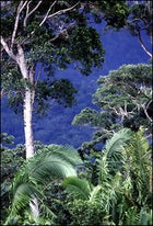
From the nearby town of La Unión, La Muralla's steep, pine-covered slopes can look something like Montana; it's just that the white, fluffy stuff covering the summits isn't snow, but low-lying clouds. The near-constant misting action on high has bestowed upon this 42,000-acre park some of the thickest cloud forest in the Americas: mossy, high-altitude tropical woodlands that shelter such creatures as the shy quetzal—worshiped by the ancient Maya and modern birders alike—and even a few tapir and jaguars. Tucked in the northwestern corner of the state of Olancho, La Muralla was officially designated a national park in 1992, serving as the model for a system that now includes 18 such preserves nationwide. It's still eastern Honduras's most accessible and best-developed park, with latrine-outfitted campsites, well-marked trails, and a state-of-the-art visitor center that wouldn't be out of place in Yellowstone (but feels a little so here).
To get to La Muralla from La Unión, hitch an eight-mile ride on the pickup that leaves daily around 8:00 a.m. from the office of the Parks and Forestry Department (abbreviated as Cohdefor) a few blocks east of the town square. (You can also hire a guide here for about five dollars a day.) Or walk for three hours up the dirt road marked El Díctamo/La Muralla. Pitch a tent on the visitor center lawn and share supper with one of the three rangers who live here on rotation and always seem ready for company. Or hike up to one of two campsites off the 2.3-mile El Pizote trail, which loops behind the visitor center; you'll find the best site beside the river on the nearby Monte Escondido trail. Either way, make sure to venture out early the next morning to maximize your wildlife-spotting opportunities.
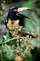
Flocks of squawking parrots and emerald toucans hang out near El Pizote's benches. But for a full-day tromp through nearly untouched cloud forest, try the six-mile, four-hour climb up the Monte Escondido, which splits off to the east, descends steeply to cross the river, and then heads up to a ridgetop. Towering oak, mahogany, and aguacatillo (wild avocado) trees form a canopy overhead, their branches draped with ferns, flowering vines, and bromeliads. Getting wet—a combination of sweat and mist—is unavoidable. Step off the trail onto forest floor so spongy with saturated organic matter that you almost bounce. Disturb one of the ubiquitous spider monkeys in the area, though, and he's likely to chase you, ripping off seeds, leaves, and branches as he runs across the canopy, pelting you with uncannily good aim.
At the summit of Montana La Muralla (6,516 feet), you'll enter a stand dominated by giant palms. Lofty redwoods these eight-footers are not, but they have survived unchanged since prehistoric times. Rest awhile beneath their venerable fronds and contemplate how this mountaintop has escaped alteration by any but natural forces. And gather your strength: There are many projectiles to dodge before you sleep.
El Carbón
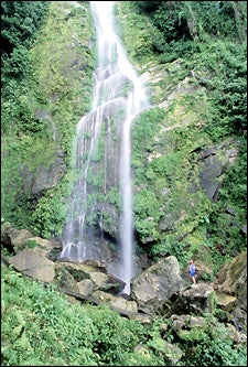
A hundred miles farther east, El Carbón is a traditional Pech village that's a microcosm of the region's divergent cultural and topographical elements: an outpost for one of Central America's smallest indigenous groups, surrounded by mestizo cattle ranchers and set in a landscape that's a mix of savanna, pine-forested mountains, and tropical rainforest. The 900 or so Pech villagers are now working to have this area designated an anthropology and ecotourism preserve, and indeed El Carbón makes a convenient base from which to hike out both to mysterious pre-Hispanic ruins and to La Cascada, a 260-foot waterfall that plunges spectacularly into Lago de la Sirena.
Just north of the pueblo's hundred or so thatch-roof adobe huts, along the road to the Caribbean coast, ask the bus driver to drop you off at the colegio. Behind this cement-block building are two newly built hostels with clean, comfortable beds for three dollars a night. Ask here for Linton Escobar, the indefatigable, 32-year-old leader of the local ecotourism cooperative, who'll set you up with a Pech guide for five dollars a day. Escobar can also arrange a botany hike with Natividad García—a wiry, thoughtful curandero of about the same age who can explain the medicinal uses of even the most innocuous-looking plants—as well as a day trip to an unexcavated ruin near the village of Agua Amarilla. Thought to have been built by the ancestors of the modern-day Pech, only the outlines of walls, stairways, and what may have been a ball court are visible under the dense jungle growth.
Better yet, take the overnight trip out to La Cascada. You'll hike for three and a half hours, much of it along a trail that winds 70 feet above the Río Ojo de Agua. The sound of fast-flowing water echoes up from the narrow gorge, but dense surrounding forest often blocks your view. Then the gorge opens up and you see the falls: a 100-foot-wide sheet of water that breaks into scores of rivulets as it tumbles over vine-covered boulders, finally dumping into a pool of water the size of two football fields. Jump in and swim out to the group of rocks in the middle of the lake, which is about as close as you can get to the mist-churning blast: Its sheer force will take your breath away, literally if not figuratively.
Parque Nacional Sierra de Agalta

Isolated in eastern Olancho, Honduras's second-highest mountain range and its accompanying 148,000-acre national park keep away all but the most determined hikers—the sort who instinctively know that the four-day, 12-mile trek up La Picucha, Agalta's highest peak at 7,723 feet, is worth taking both for what you won't see (other hikers) and what you will: an honest-to-God dwarf forest atop the summit.
Though Grupo Ecologico de Olancho can arrange guides—contact Conrado Martinez at the Cohdefor office in Catacamas (011-504-885-2873)—a good sense of direction will get you there solo. From Gualaco, head north toward San Esteban, turning east after three miles onto a marked dirt road, which you'll follow until it dead-ends at the trail. You'll then climb for about four hours along a sweet-gum-forested ridgetop and then zigzag across the Río del Sol until you reach a two-pronged waterfall at La Chorrera, the base camp where you'll sleep the first night. From here, the sometimes faint trail rises steeply for five hours. If you get thrown off while circumnavigating one of several hurricane-felled trees, just look for machete marks and backtrack to the trail. Pitch your tent when you reach a tiny clearing with fire pits.
During the two-hour ascent the third morning, the world around you changes form: The trail is masked by a dense, slippery mass of aboveground roots; the air becomes wetter, intermittently opaque; and the forest shrinks, its gnarled, stunted pines covered in moss and lichen—a rare ecosystem cooked up by the altitude, high winds, and near-constant moisture. If the gods are smiling and the skies are clear, you'll command 360-degree views over the treetops, from 8,010-foot Pico Bonito on the northern coast to the parrot-green Mosquitian jungle off to the east.
Back down at the foot of La Picucha, head east to the nearby town of Catacamas and then embark on a day trip to check out eastern Honduras's newest tourist attraction: the Cave of the Glowing Skulls. Discovered by amateur spelunkers in 1994, this 3,000-year-old burial chamber holds nearly 200 skeletons that sparkle cinematically in the light, thanks to aeons of calcite dripping from the roof. The remains, which long predate the Maya, may have belonged to ancestors of the Pech. The tourist-courting Honduran government has been busily building facilities—including ladders, platforms, and electric lighting—so that visitors can safely peer into the chamber, which is located on a ledge 30 feet above the cavern floor. The newly revamped cave is slated to open this fall, but you'll want to check with the Cohdefor office in Catacamas before heading out.
Río Plátano Biosphere Reserve
Look closely at a map of Honduras and you'll notice the entire province of Gracias a Dios has not a single road leading to the rest of the country. This is La Mosquitia, the legendary Mosquito Coast, of which nearly two million acres of rainforest, savanna, mangrove swamps, and lagoons have been protected since 1980 as the Río Plátano Biosphere Reserve.
The best way in is to catch a short flight from the north-coast towns of La Ceiba or Trujillo out to Palacios, a small village at the mouth of the Río Sico. Circling Palacios in one of Aerolíneas Islena's weathered, 19-passenger turbo-props, you might begin to wonder where the landing strip is. Fear not—it's the grassy field in the center of town, right next to that wreck of an earlier flight.
After your plane bumps to a halt, head for the docks just past the Islena office to catch a water taxi ($3) to the Butterfly Farm in Raistá, a small village on a narrow strip of sand between lagoon and ocean. The farm—which sells larvae to U.S. zoos and research institutes—and the adjacent guesthouse are run by a lanky, amiable Miskito named Eddie Bodden. His place is much quieter than the two hotels in Palacios and has the added bonus of a deserted Caribbean beach a couple hundred yards away. Manatees frequent the shallow, calm lagoon.
Bodden can help arrange for a boat up the Río Plátano to Las Marías, a small Miskito and Pech village in the heart of the reserve. Gas is expensive out here, so don't be surprised at the price: around $80 round-trip, plus $10 for each night the captain spends in Las Marías waiting to ferry you back. If you're not already with a group, try to hook up with a few other travelers to split the cost. The tuk-tuks (so called for the unhurried chugging sound of the ancient outboards) take six to eight hours to reach Las Marías, so bring a towel for the hard seat and a hat for the sun—and ask your captain to brake for especially swim-worthy eddies. Along the river's winding route you'll pass Miskito families in slender, mahogany dugout pipantes: women and children huddled in the middle, men standing up in back to impart leverage to the long poles they use for propulsion.
By the time you've secured a two-dollar bed in one of Las Marías's five unmarked “hotels”—stilted wooden buildings set high on a bluff above the river—Martin Herrera will no doubt have made himself known to you. Leader of the local guiding cooperative, Herrera arranges all trips, at fixed prices and led by a rotating crew of 80-odd guides. The best outing is the four-day journey south along the unpopulated upper reaches of the river, where you'll see otters, packs of howler monkeys, and even six-foot-wingspan king vultures. Overnight trips cost $22 per pipante per day, which includes the three guides needed to pole the boat upriver. Each dugout holds two tourists plus supplies.
A few hours south of Las Marías is the mysterious petroglyph of Walp'ulban'sirpi (the Miskito word means “small carved stone”), a two-headed serpent etched into a river boulder. If you camp nearby, the next morning you'll reach the Class II Brokwell rapids, named for an American gold miner who lost all his gear here in the '50s. To avoid Brokwell's fate, the guides will portage if the river is high. A bit farther upstream is Walp'ulban'tara (“big carved stone”), more extensive petroglyphs depicting monkeys, birds, and human figures.
If you make it this far, it's worth traveling at least one more day upriver into the rainforest near the confluence with the Río Cuyamel, where you'll have a good chance of seeing rare tapir and wildcats long since hunted down closer to Las Marías. Unfortunately, many guides see these trips as a great opportunity to go on a backwoods hunting binge, occasionally even spearing a monkey and offering to share bites of the highly coveted brain. If you'd rather avoid such gourmet morsels, insist that you don't want them to hunt for you and do your best to discourage hunting for themselves. Though you may have trouble understanding them unless your Spanish is good, the guides are immensely knowledgeable about the surrounding jungle. One of their favorite stunts is to reach up and grab a thick bejuco de uva vine, slash it open with a machete, and quench your party's thirst with the water stored inside.
With the current at your boat's stern, you'll be back in Palacios in no time, availing yourself not of vine juice but of the aptly named Salvavida (Lifesaver) beer. Damn tasty, both beverages. But as you pack up and get ready to brave the flight home, odds are that the flavor of the quietly gathered raindrops is the one that's trickled deeper into your imagination.
Into the Interior: How to Cut Your Own Path in the Hundran Hinterlands
In the verdant mountains of Honduras, pleasant weather is all but guaranteed during the cool, dry months—October through April—whereas rain will pound you, regardless of the season, along the Caribbean coast. So though the shore does have its between-downpour consolations (diving, sea kayaking, etc.), it's best to hop a plane, bus, or rental car and head straight for the hills.
Getting There: Taca Airlines (800-831-6422) runs direct flights to La Ceiba—gateway city to La Muralla National Park as well as to the sybaritic Bay Islands of Roatán, Guanaja, and Utila—from Houston ($625 round-trip) or from JFK through San Pedro Sula ($750).
Getting Around: Honduran “highways” have a habit of deteriorating as you stray from major cities, so if you're renting, snag the sturdiest-looking model on the lot—and best not to tell the attendant exactly how far you're headed. You can hire a car in San Pedro Sula for about $45 per day from Hertz (800-654-3001) or Avis (800-331-1084), which also has a La Ceiba branch. Or travel as the locals do: by bus. Fares are negligible and schedules somewhat negotiable, though you'll need to brush up on your frantic double-arm overhead wave, as formal bus stops are ignored nationwide. To get to La Mosquitia, however, you'll have to travel by air. Islena Airlines (011-504-233-9813) flies to Palacios from Trujillo (a beach town 50 miles north of El Carbón) for $35 one-way, and from La Ceiba for $43.
Outfitters: For guided trips in La Mosquitia, call legendary local guide Jorge Salaverri, who grew up on the Río Coco and explored this region on his own for two decades before founding La Ceiba-based La Moskitia Ecoaventuras (011-504-442-0104) four years ago. Ecoaventuras runs everything from three-day tuk-tuk cruises along the lagoons near Palacios to rigorous, 14-day raft trips down the most remote sections of the Río Platano; prices range from $414 to $1,729.