

When filmmakers and contacted us about their latest project, The Classics, we were intrigued. They planned to produce seven short films about North AmericaŌĆÖs best destinations for sea kayaking, climbing, skiing, mountain biking, and more. When Cahall invited us to join him for a shoot, we couldnŌĆÖt refuse. A kayaking trip along the Georgia coast in November sounded like the perfect break from office work. That, and we wanted to see how the team behind and went about their work. In the end, we ended up with a new multimedia travel package: our guide to tackling North AmericaŌĆÖs epic quests alongside their video series. Let us know if you like the format.
Sea Kayaking Georgia
Paddle the marshes, inlets, and rivers of the Atlantic Coast
Georgia
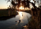
Last November, when I was invited to go sea kayaking off GeorgiaŌĆÖs coast with , a lifelong paddler from Savannah, it wasn’t the paddling I was excited about. It was picking oysters in the swamps surrounding GeorgiaŌĆÖs some 1,200 marshy islands.
I flew into Savannah and drove 40 minutes east to Tybee Island, a clutch of second homes and seafood shacks that serves as the launching point for sea kayakers heading into the roughly 400,000 acres of tidal marsh buffering the state’s coast. From Tybee, most paddlers head south, and so did we, straight into a headwind. ŌĆ£ItŌĆÖs not usually this windy,ŌĆØ Mike yelled over the howl.┬Ā But it didn’t matter. Dolphins breached a paddle length from my cockpit and a flock of thousands of red knots swept overhead. After a couple hours of paddling through plains of yellow sea grass we made camp under a stand of live oaks. I spent the afternoon napping in the sun and waiting for the retreating tide to reveal oysters. I found them just before sunset: a colony clinging to a dead treeŌĆōexactly where Mike suggested I leave them. “They’ll taste like rotting wood,” he said.
In the morning, the tide swept back in and we paddled saltwater creeks not much wider than the boats, past stands of southern magnolias, and surfed in the open Atlantic on waves kicked up by a 30-knot wind. When we got back to town, Mike tried to make up for the lack of oysters. (I insisted). He took me to a seafood shack that sells the local bivalves in 100–pound burlap sacks. They sold out that morning, so we left with a rack of cheap beer and a sack of imports from northern Florida. Back on Tybee, Mike BBQ’d the oysters in their shells.┬Ā By the time we called it a night, I’d eaten 80 and made plans to returnŌĆōonly if I could pick my own oysters. That is, of course, unless I couldn’t.
DIY TIPS: When the Deepwater Horizon exploded, gushing millions of gallons of oil into the Gulf Coast, sea kayakers (and everybody else) cringed. But there are still plenty of opportunities for southern sea kayaking, like the nearly 400,000 acres of remote marsh off GeorgiaŌĆÖs Atlantic Coast. Fly to Savannah between October and November, when the temperatures drop to the fifties at night and a cool wind comes out of the north. Get a taste for the marsh on a beginner-friendly three-day trip around the dozens of hammocks that make up the island complex of Little Tybee. Launch from Alley Three, a public dock on the south side of Tybee Island, and head southeast along beaches that face the open Atlantic. Set up camp for two nights under the live oaks on the ridgeline that forms the southern tip of Little Tybee. The next morning, paddle two miles south to the wildlife sanctuary at Warsaw Island, keeping your eyes peeled for sea turtles, fresh oysters, and 250 species of birds. Return to Alley Three via JackŌĆÖs Cut, a tidal creek that cuts through Little Tybee.
YOU NEED: A sea kayak, tidal charts, and aerial photos of Little Tybee’s hammocks. Get the paddling gear at Savannah Canoe and Kayak, a funky shop on the road out to Tybee (kayaks $50/day), and eat at , a southern-style beach joint on Tybee that specializes in pizza and cheap beer.
Mountain Biking Vancouver
North Shore riding at its best
Vancouver
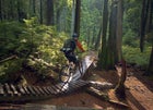 Riding singletrack outside of Vancouver
Most cities build public trails for mountain bikers. So does Vancouver, Canada, but┬Āthey also turn a blind eye to the construction of unsanctioned (and remarkably well-maintained) trails. The result is more than 400 miles of downhill and cross-country singletrack within a half hourŌĆÖs drive of downtown. First time riders start at 3,900-foot Mount Fromme, a cedar-covered peak woven with trails on the northern edge of Vancouver. For a sane sample of the elevated sidewalks, optional tabletop jumps, and cobblestone rock gardens that have come to define North Shore riding, beeline it to Ladies Only. It’s one of dozens of trails off the Mountain Highway, and a mile long downhill that winds through classic Vancouver scenery: babbling brooks, massive forests, and even lawn art. The builder, appropriately named Digger, stashed a sloth and flamingo in trailside trees.
YOU NEED: A four-inch travel bike, a trail map, and two hours to ride the Ladies Only loop. You can get the first two at , which is five blocks from the trailhead (bikes $65/day). Post-ride burgers and brews come from the , a neighborhood joint thatŌĆÖs riding distance from the trailhead.
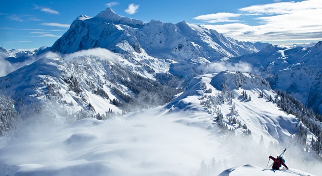
Skiing Mount Baker
Boot-pack up the Shuksan Arm
Skiing Mount Baker
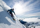 The fun part
░┬▓╣▓§│¾Š▒▓į▓Ą│┘┤Ū▓įŌĆÖs Mount Baker has no coffee shops, no on-slope lodging, and no cell phone service. What it does have is access to endless side country and the record for the most snowfall in one season (1,140 inches in 1999). ŌĆ£ItŌĆÖs as close to skiing Alaska as it gets,ŌĆØ says local skier Molly Baker. From the top of Chair 8 follow a boot pack east out the Shuksan arm, a four-mile ridgeline that connects to the top of the 9,000-foot Mount Shuksan. The lines off the ridge range from wide-open powder chutes to mandatory 60-foot airsŌĆōso scout from the chairlift. Start with the Heli Line, a 40-degree chute that takes 45-minutes to hike to from the top of Chair 8 and funnels skiers back to the bottom of the lift. There are no guidebooks to the area, but ask questions of the notoriously friendly locals.
YOU NEED: Skis with a minimum of 110 mm underfoot, beacon, shovel, and probe. Get last-minute gear at , and book ahead at the , a European-style chalet 40 minutes from the mountain.
Backpacking the Wind Rivers
A multi-day hike to WyomingŌĆÖs Titcomb Basin
Wind River
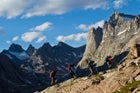 The climb up
ItŌĆÖs not true to say Wyoming’s is exactly like the Tetons. They donŌĆÖt have a conga line of RVs pacing at their base. Spend five days hiking around the and youŌĆÖll start to see the similarities: 35 peaks taller than 13,000 feet, 2,300 alpine lakes, and more than 600 miles of trails. To get a sense for what the range offers, hike to Titcomb Basin, a remote five-day out-and-back that starts at Elkhart Park. Over 15 miles the trail climbs 2,000 feet to a granite cirque filled with five lakes. Camp on the 200-foot-wide finger that separates the upper and lower lakes and expect to wake to alpenglow on the Sphinx and Miram Peaks, a pair of granite crags ringing the cirque. Bring a flyrod. Last year the Forest Service restocked the basin with golden trout.
YOU NEED: A fishing license and Bridger Lakes and Gannet Peak 7.5 minute quads ($8) from the Great Outdoor Shop in Pinedale, and reservation at Pole Creek Ranch, a western-style bed & breakfast ($65/couple).
Ice Climbing New Hampshire
The best routes near North Conway
North Conway
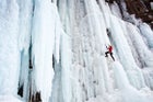 Climbing ice near North Conway, New Hampshire
ItŌĆÖs between January and March that locals earn the right to claim that New HampshireŌĆÖs gets the worst weather in the world. Temperatures hover below freezing, and 30 inches of precipitation falls on the 5,000 feet of relief that separates valley towns like North Conway from the peaks of the White Mountains. In other words, itŌĆÖs an ice climberŌĆÖs paradise. Within an hour’s drive of North Conway there are more than 400 ice routes. The most consistent ice climbing is at , where a series of natural springs flow over, and then freeze to, a 300-foot band of granite cliffs. The result is a collection of 40 routes that range in difficulty from WI 2+ (beginner friendly) to WI 5 (experts only). To access Frankenstein, drive 20 miles northwest of North Conway on Route 302, and hike out the railroad tracks until you hit a trestle built in the 1800s. The cliffs are a short walk to your right. First timers, try Lost in the Forest, a 100-foot tall ice flow with a good mix of WI 2+ and WI 3+ climbing.
YOU NEED: A lesson from the North Conway-based (starting at $120/per person/day with equipment), an extra down puff for the belayer, and a reservation at , a bed and breakfast with a special room to dry wet climbing gear ($95/night).
Mixed Climbing in the Bugaboos
Bag Pigeon Spire with Yamnuska Mountaineers
Bugaboos
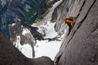 On the Beckey Chounaird route up the South Howser Tower
For climbers, the Bugaboos’ allure is undeniable: seven granite fins rising as much as 3,000 feet above glaciers. Getting there is the challenge. The 33,720-acre sits 40 miles down a gravel road southwest of the town of Golden, British Columbia. To access the peaks, hike four miles up a 2,100-foot well-maintained track to the moraine of Crescent Glacier. Your reward is , the 40-person alpine shelter thatŌĆÖs the launching point for hundreds of the best climbs in North America. Hire a guide from Yamnuska Mountaineers and sign up for their five-day , which takes fit beginner climbers up four ultra classic routes. The highlight is the West Ridge of Pigeon Spire, which mixes glacial travel and fourth class scrambling with a handful of 5.4 pitches.
YOU NEED: To reserve a spot on MountaineeringŌĆÖs Bugaboos Granite trip three months in advance ($1800 per person for everything but transportation). If you park at the trailhead, you also need to wrap your car in chicken wire to prevent porcupines from chewing the rubber gaskets.
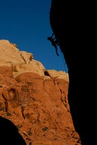
Climbing Red Rocks
Bouldering, sport, and traditional routes near Las Vegas
Rainbow Wall
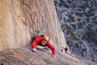 Climbing the Rainbow Wall
Pier Cragg
 Climbing Pier Cragg
That is 20 minutes from the Las Vegas strip is nice. That you camp for $15 a night at the foot of more than 2,000 climbs graded from 5.4 to 5.13 is good too. The best part of Red Rocks though is it offers more than just about any other area in the world. The 195,000-acre labyrinthine park of blood-red sandstone has everything from sport routes (on a hot day, try the 5.8 to 5.12 routes that line the Dark Corridor) to boulder problems (thereŌĆÖs hundreds in Calico Basin alone) to big-wall epics that go from 5.4 to 5.12. For many, Red Rocks best routes are the easy ones, like Cat in the Hat, a five pitch 5.6 that winds up 500 feet of juggy face climbing and splitter cracks. Bring water (a gallon a day, youŌĆÖre in the desert), a headlamp, and allow time for route finding.
YOU NEED: A set of climbing nuts and a double rack of Black Diamond Camalots; a guide book, like , and a reservation at 13 mile ($15/night)