
In the fall, Arizona’s intense triple-digit heat keeps hordes of otherwise-active folks inside, ensconced in their air-conditioning. But once the mercury drops, the legions depart from their shaded lairs and head for the trails, bathed in temps tailor-made for day hiking. And one of the state’s biggest spots to witness this seasonal migration is Phoenix. Arizona’s capitaland the sixth-largest city in the countryand the neighboring town of Mesa, sit a few piddling miles from breathtaking mountaintop views and invigorating rocky ascents along sheer sandstone cliffs and manzanita-lined trails.
Phoenix
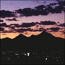
 Here There Be Mountains: Phoenix at dusk
Just 15 miles east of Phoenix, Mesa lies on the outskirts of the Tonto National Forest and a whopping 900 miles of trails. Almost six million visitors come here each year to explore preserved areas such as the Mogollon Rim and its trout-filled streams. Start in the Payson Ranger District
If your pace and appetite allow, eat lunch at the junction of Horton Creek and Highline trails, about halfway into the hike. A right turn east leads to a clearing near the creek, while wandering a bit further upstream will take you to moss-covered stones and the source of cascading falls. And if you’re game, you can turn this out-and-back trip into a ten-mile loop by following Highline to Derrick Trail; just be sure to pick up a map first. The Mesa Ranger Station (480.610.3300; 5140 E. Ingram St.) sells them for $6 each.
Usery Mountain Recreational Area, another well-known Mesa destination, offers over 3,600 acres to explore, but a 3.2-mile leisurely hike on the Wind Cave Trail might stave off the need to conquer it all. This trek through the lower Sonoran Desert takes visitors along a sandy path with expansive views of the valley floor. As you start, your end destinationthe Usery Mountainsrise off to the east. Along the mountain base you’ll find a cave adorned with lush greenery irrigated by the water seeping through the cave walls. If you’re up for more exploring, take a right, going east from the cave, to scramble up to the 3,100-foot summit, about a half-mile away. The trail is well maintained, though narrow, and requires climbing over a steep rock wall. Stunning views of the Superstition Mountains and Four Peaks looming in the northeast reward the ambitious.
If you’d rather stick within the city limits, Phoenix has its share of power hikes. Camelback Mountain, at 2,704 feet above sea level, is the most identifiable landmark in the city and the perfect place for an early morning sunrise workout. But a 360-degree panorama of the valley and surrounding Maricopa and Gila mountain ranges doesn’t come easy. Each summit trail gains approximately 1,200 feet in just over a mile; stairs made of railroad ties will help you up. While you’re catching your breath, be sure to stop to sniff the prickly pear along the trail. The mountain, located in the Echo Canyon Recreation Area (602.262.4994; ) off East McDonald Drive, is open from 6 a.m. to 7:30 p.m.
Amy Clark
Additional Info: