
Tackling a potentially explosive beast on foot can be intimidating, but rewarding. The United States is home to 103 volcanoes, 50 of them active (read: having erupted within the past 200 years). All known eruptions occurred in Washington, Oregon, and Northern California, part of the Pacific Ring of Fire (AKA: the volcanoes and mountains around the Pacific Ocean). Fortunately, there are some non-technical climbs that will get you to the summit of a few of these geological giantsnone of which are about to erupt any time soon.
Mount. St. Helens
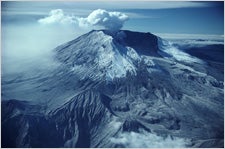
 Washington state’s Mount. St. Helens
As implied in the last paragraph, plan to head west coast to find your pick of lava domes. One that delivers both breathtaking views and a challenge is Oregon’s South Sister. The youngest of the Three Sisters (North, Middle, and South), this 10,358-foot mountain formed approximately 100,000 years ago as part of the Cascade Volcanic Arc, a series of volcanoes that extends from California to British Columbia.
Travel north just past the Oregon/Washington border and you’ll encounter the most popular volcano in the States. Notable for its massive eruption on March 20, 1980, Mount St. Helens continued to experience volcanic activity until as recently as July 10, 2008. Fortunately, the USGS has lowered the volcano alert level to normal, meaning no immediate threat of eruption. Hiking to the volcano rim at 8,365 feet is best in late spring through early fall, and most use the Monitor Ridge Route from Climbers Bivouac trailhead. Although there is a 4,500-foot gain over five miles, the climb is not technical and can be completed in seven to 12 hours. The route begins on the Ptarmigan Trail #216A and gently climbs for about two miles to the timberline. Above timberline, the route travels over steep, blocky lava flows on the lower slopes and loose, sandy volcanic ash on the upper slopes. The trail ends and wooden poles mark the route to Monitor Ridge. While climbers are sometimes required to scramble boulders, the terrain turns into smooth, soft volcanic ash near the crater’s rim. Climbers who reach the top take in spectacular views of the mile-wide crater, a glacier, and the frequently steaming lava dome. Mount Rainier, Mount Adams, and Mount Hood can all be seen on clear days, as well as the huge landslide where the top of the volcano exploded and slid down into the Toutle River Valley. All hikers should continue to be cautious when nearing the crater’s unstable rim. Cascade weather can also change quickly, so climbers should carry warm clothing and rain gear. Check the snow pack ahead of time and plan to bring skis or a snowboard for the trip back down. Permits are required year-round and cost $15 plus a service charge of $7 per person for a one day climbing permit. Climbing is limited to 100 climbers per day May 15 through October 31, and all climbers must register outside the Lone Fir Resort in Cougar, Washington. To get there from Interstate 5, take Exit 21.
If you’re looking to reach new heights and record elevations, head to northern California’s Mount Shasta. Get your non-technical climb up one of the tallest volcanoes in the Cascade Arc, at an elevation of 14,179 feet. The second highest peak in the Cascades, Shasta’s last eruption was thought to have occurred 200 years ago. Summer climbing season runs from late April until October, but winter attempts are possible. The most popular route is Avalanche Gulch, also known as the John Muir Route. Beginning at an elevation of 7,900 feet, the trail on the southwest side of the mountain begins at Horse Camp Cabin near the treeline. The route includes 6,300 feet of vertical gain across moraines and snowfields. While experts recommend packing an ice axe and crampons, this route is the most popular and considered non-technical. After the snow has melted, Clearcreek becomes another hikeable route on the southeast side of the mountain. The elevation gain is greater because the trailhead begins at 6,480 feet, but the grade is more manageable. You’ll also find the most scenic views overlooking Mud Creek Canyon. While the trail is approximately a straight shot from the parking area, footing is sandy and notoriously slow-going. Near the top, watch out for hot pools of water bubbling with sulfur gases, proof of Shasta’s lively volcanic activity. From the summit, Lassen Peak, Mount McLaughlin to the north, Shasta City below, and Shasta’s sister volcano, Shastina, can all be seen on a calm day. Summit passes are $20 and available at all trailheads.