
The Ultimate Arches National Park Travel Guide
This 76,000-acre wonderland is less a park and more a sandstone sculpture garden of sunset-hued arches and domes that look like they were carved by some alien magic. Here’s how to outsmart the crowds.
New perk: Easily find new routes and hidden gems, upcoming running events, and more near you. Your weekly Local Running Newsletter has everything you need to lace up! .
It was the middle of the day in the middle of July the first time I visited , and the foolish act of stepping outside my perfectly air-conditioned car was a bit like being body-slammed by Satan himself. Still, as an experienced desert hiker, I loaded up with several liters of water, spackled myself with sunscreen, and hoisted my reflective umbrella before setting off for Delicate Arch, the famed��figure��of many a Utah license plate.
My sweat equity paid off, and for a few moments I had the place to myself—pretty amazing, considering this is one of the park’s most iconic stops. Maybe it was the heat, but at first glance, the arch, perched on the edge of heat-seared nothingness, seemed like some otherworldly desert portal to another dimension. Except if you stepped through, you might run the risk of slipping off into a whole different kind of space.
Of course it’s not alien magic that carved Delicate Arch or any of the park’s other stunning formations but the decidedly more terrestrial power of seismic activity from the nearby Moab Fault, coupled with weather-caused erosion that’s been working for millennia to split, buff, crack, and carve this sandstone sculpture garden of sunset-hued arches, fins, and domes.
Before earning its spot as one of Utah’s five national parks in 1971, this fantastical landscape��spent over 40��years as a national monument. It was during this time that esteemed��writer and environmentalist Edward Abbey worked at Arches as a seasonal ranger, documenting��both his love for the area��and his disdain for people’s poor treatment of it in the classic Desert Solitaire. Abbey, whose reputation in recent years has become controversial for��the racist and sexist undertones in his writing,��spent only two years at the park, however; its original caretakers were first the Fremont people, followed by Hopi, Navajo, Paiutes, and Ute, who are still connected to this enchanting place today.
What You Need to Know Before Visiting��
Watch the mercury (and your H20 intake). During��my��first visit, I saw two people leave the trail on stretchers. Heat-related illness is a common affliction for those��who fail to respect both the weather and their own bodily needs. Park guidelines suggest consuming��a gallon of water per day year-round to stay hydrated during your time at the park,��and after I slurped down nearly three liters on a three-mile hike, I’d say that advice is��pretty spot-on. You’ll find water at the and at the and trailhead. Shade is even harder to come by than water once you leave the car.
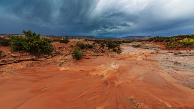
Enjoy—and respect—the power of wind and water. The park’s incredible formations wouldn’t exist if not for the heavy-duty scouring power of Mother Nature at her most intense. Of course, these same erosive forces continue to shape Arches��today. Visitors have been stranded on trails and roads when flash floods inundate low-lying areas, and others have been gripped by quicksand after heavy rains. Sandstone fins (narrow walls that remain after surrounding rock has been eroded away)��are no place to be near during high winds��or when slicked with rain, snow, or ice. And sudden rockfall is more common than you’d think. doubled in size after dislodging a hefty boulder in 1940, belched up some of its innards in front of surprised onlookers in 1991, and disintegrated under the cloak of darkness in 2008.
The park feels crowded, but it actually isn’t. Relatively speaking, Arches is a fairly compact park (at roughly 76,000 acres), with very few named routes. This means that viewpoints and trails (not to mention front-gate traffic) can often feel jammed. You can still beat the crowds, however, by going the extra mile—literally and figuratively. Set the timer on your coffeepot and commit to arriving before dawn. Not only is it absolutely awe-inspiring to watch sunrise light up the sandstone (along with the La Sal Mountains to the southeast), but it’s also a smart way to sneak in some solitude on the park’s most popular trails. I also recommend going deep and striking out on Arches’ network of unpaved roads. Developed areas make up only a tiny portion of the park’s acreage, and there’s so much more to see once you leave the pavement behind.
How to Get There
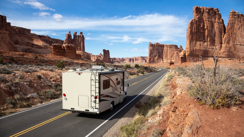
Arches is located off��U.S. Route 191, just north of the adventure outpost of Moab, which is centrally situated��near Utah’s border with Colorado. Those who fly��can land at tiny (about 15 minutes north of the park entrance), (about an hour and a half east), or the much bigger (three and a half hours northwest). Bus and train service will take you as far as Green River, a quiet burg known for its paddling access and tasty melons, some��45 minutes from Moab. No matter which option you choose, you’re still going to want a car, which you can rent in any of the places listed above. While you can pay for a to cart you around, there is no public transportation inside the park.
When Is the Best Time of Year to Visit Arches National Park?
Winter
Snow isn’t uncommon during the winter months when temperatures hover in the forties during the day and routinely dip below freezing at night. But if you’re prepared with the proper gear, it’s a real treat to see the vivid red-rock landscape all iced up like a somewhat psychedelic gingerbread cookie. Another upside for your efforts? This time of year is when the park experiences its lowest visitation and you’re most likely to snag a site at its sole campground.
Spring
Welcome back, humans! Between the thawed-out trails and crowd-drawing events like the , an annual off-roading get-together that involves four-wheelers tackling��the backcountry, prepare to jostle for space at popular viewpoints and on shorter trails, as well as for lodging and dining in town. Still, it’s hard to beat Arches this time of year—the mercury begins to rise, with daytime highs topping off in the sixties��and seventies, and tiny wildflowers start to sprout from the desert crust.
Summer
Despite my aforementioned Delicate Arch adventure, I maintain that the best way for most folks to experience Arches in the summertime is from inside an air-conditioned vehicle or toward��nightfall, when temperatures slide into the sixties. That said, I’ve seen just as many people crawling along its trails in July as I have in March—that is, a lot. I can’t say it enough: carry lots of water and drink said water, no matter what kind of activity you’re doing in the park. And come prepared for the monsoon season, which is marked by intense thunderstorms prone to causing flash floods; this season��begins in July and can last through September.
Fall
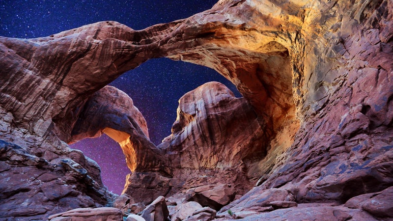
Sweet relief! Temperatures dip back down to mirror springtime conditions, and luckily, come November, the hordes��begin to do the same. Darkness arrives more quickly this time of year, but that just leaves more time for stargazing; consider signing up for a to maximize the experience.
Where to Stay in and near Arches National Park
Camping
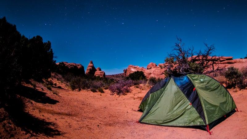
The only��lodging option inside the park is the ($25), a slickrock-flanked oasis at the end of the park’s main road. Reservations are available and recommended via Recreation.gov March through October and are available up to six months in advance; its 51 sites are first come, first served for the rest of the year.
If you strike out, however, there are plenty of other options scattered around the greater Moab area, including an endless parade of stuffed with equally endless amenities. Feeling fancy? Ramp it up a notch (or several) with a glamping experience at Moab’s outpost (from $300), located about seven miles north of the park entrance.
For more rustic surrounds, bunk down at one of 26 different BLM camping areas dotted around the area, all of which are first come, first served (from $10), except for the reservoir-adjacent ��($20), which requires advance reservations from March through mid-November. While the picturesque sites dotting the Colorado River are always full, I’m partial to the ones scattered along the more remote Kane Creek Road, tucked beneath sheer walls of red rock. If you pitch a tent��at ��($20), it’s only a short walk to enter its namesake gorge, where idyllic swimming holes provide the perfect escape from summer heat (and Arches crowds).
Hotels
I’m not sure what the exact hotel-to-resident ratio is in Moab, but it’s gotta be pretty high. That said, it’s still competitive to snag any of the more “affordable” options in town, especially on a weekend, especially during high season, and especially if you’re coming through at the last minute. I once stayed at a cheap chain motel in Green Valley—a soul-draining 45 minutes away—after making such a poor planning decision myself.��In Moab, I have a certain affection for the (from $16), a sort of ramshackle collection��of traditional bunkhouse dorms, private rooms, and extremely simple log cabins located on the south end of town. If someone else wanted to foot the bill, though, I’d happily shack up at the dreamy (from $780), an upscale resort nestled along the Colorado River about a half-hour east of the park. Families dig the (from $200), a roadside motel right in the heart of town that’s been jazzed up with retro decor, an arcade, and a waterslide. (from $153), a colorful selection of condo-like suites, is also centrally located (and generally quieter). Closer to the park entrance, the�� (from $120) is a more traditional midrange hotel featuring a pool, playground, coffee bar, and surprisingly robust breakfast buffet.
What to Do
Sightseeing
Get the lay of the land by cruising��the park’s 18-mile , which rolls past a handful of pull-outs and overlooks that showcase the most fantastical examples of this wild landscape. A spur marked by signage��for the park’s —so named for the portholes that have been gouged from the rock—is worth the trip��as well.
Day Hiking
Yes, it’s worth the hype—you really should see Delicate Arch while you’re at Arches. You don’t have to make the somewhat strenuous three-mile round-trip to do so (although it’s a great hike); instead, bypass the trailhead and drive a little farther down to a pair of viewpoints. The lower one is only 50 yards from the parking lot along an accessible path, while the upper one rewards a half-mile climb with a closer look.
Another accessible and very worthy stop is the gravity-defying , which can be seen from its parking lot or from a 0.3-mile loop, roughly half of which is paved. Nearby, the Windows Area is an extremely popular stop, especially at sunrise, when you can scamper around the back side of North Window to look through and spot Turret Arch bathed in alpenglow. The mile-long , which connects its namesake overlook with the , is a quieter option (though just as beautiful)��at sunrise and sunset.
Deeper into the park, the impossibly thin (1.8 miles round-trip), the longest such span in North America at 306 feet, is a must-see. If you’re feeling adventurous (and aren’t afraid of heights), continue past this point to complete a 7.9-mile loop of the Devils Garden area; the route��travels across vertigo-inducing sandstone fins and requires good navigation skills. My favorite bang-for-your-buck hike, however, is a deceptively diverse 2.6-mile loop that links together , . Depart from the trailhead located across from site 39 in the campground (limited parking is available) to enjoy relative solitude, along with some fun slickrock and canyon travel.
Backpacking
Between the sparse trail system, lack of natural water sources, and fragile terrain (more on this shortly), backpacking in Arches is not as common as it is in other marquee parks. That said, it is possible—although you’ll need��excellent navigation and route-finding skills, the capacity to carry a lot of water (and carry out your waste), and a general air of self-sufficiency. Highly experienced hikers who are also comfortable with exposed scrambles, canyoneering techniques, and traditional map-and-compass navigation might consider hopping on what’s known as the , whose unmarked northern terminus is located in the park’s northwest corner on Salt Valley Road. Less an established path than a series of recommended routes, this 800-mile (give or take) adventure winds through some of Utah’s most stunning public lands and traverses the Grand Canyon before reaching its southern end point at Zion National Park’s Weeping Wall.
Climbing
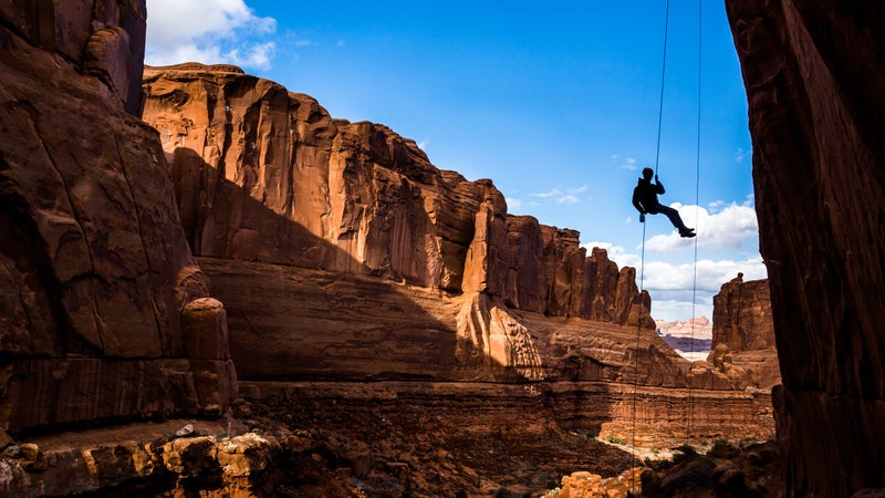
The good news is that there is climbing in the park, most of it on trad routes with fairly easy approaches. The bad news is that nearly all of the established routes are closed from March through August to allow raptors to breed in peace. If you decide to rope up outside of that time frame, keep in mind that unlike the popular area about an hour south of Moab, the sandstone here is very crumbly; avoid climbing on wet rock.
Driving
While you can’t go off-roading (or use off-highway vehicles) anywhere in the park, you can get off the beaten path by tooling around its quiet interior via a somewhat slim network of unpaved roads, one of which—Salt Valley Road—is accessible to two-wheel-drive vehicles. This route travels between the Devils Garden area and the park’s northeast boundary; a 2.6-mile round-trip near the latter deposits you at , situated��in the fantastically lumpy Klondike Bluffs. If you have four-wheel drive, make time to visit Herdina Park, an even more remote area home to several arches and zero crowds. Keep an eye on the weather no matter where you drive, and stay off backcountry roads right after a rain, when they turn into wheel-swallowing mush.
Cycling
Moab is arguably one of the best mountain-biking destinations in the U.S., but you can’t get your fix inside the park, where it isn’t allowed. That said, you can still cruise along any of its roads. Just know that you’re going to share space with a lot of cars if you stick to pavement; making the steep, narrow, winding climb from or descent��to the visitor center is not without its risks.
If you want to see at least some of Arches from your saddle, hit up the BLM’s area directly to the park’s west; it��offers a nice variety of trails with great views into the park, including a portion of Courthouse Wash and the Klondike Bluffs. If you’re visiting without a rig, rent one from the knowledgeable folks at . During my most recent visit, I grabbed a full-suspension beauty from the shop��and joined an excellent guide from (from $85), who very (very) patiently helped me feel more confident navigating over rocks after I got a little too excited and suffered an epic wipeout at��the beginning of our ride.
Canyoneering
While a handful of canyoneering routes exist in the park, the most popular by far is a journey through what’s known as the , an unmarked sandstone labyrinth that requires sticky-soled shoes, a good sense of balance, and an even better sense of direction. While it’s possible to for a self-guided trip ($3 to $6 via Recreation.gov), it’s better to buy a ticket for a ranger-led tour ($10 to $16) unless you have previous experience navigating the mazelike canyons or are traveling with someone who does. (Note: The Fiery Furnace has been closed throughout the COVID-19 pandemic.)
The Best Places to Eat and Drink Around Arches National Park
While the park itself doesn’t contain any type of food service, Moab offers a decent variety for its size. In addition to the much larger City Market, picnickers can stop by the to grab health-conscious goodies along with made-to-order deli items. Early risers should swing by to grab some solid coffee and a sandwich or burrito to go. (I’m partial to the green-chile-studded Wescial.)
Lunchtime throngs��gather in the center of town at , a bright yellow rig whose cheesy treats are on offer right next to a wider selection of wheeled delights at the . For something slightly heartier, grab a banh mi��and a yuzu limeade at , or tuck into one of ’s drool-worthy crispy chicken sandwiches. Go ahead and scoop up a few of the bakeshop’s decadent pastries while you’re there; resistance is futile.
Dinner is, of course, prime time for carbo-loading. Join fellow adventure junkies at the family-friendly for some hearty calorie bombs, or loosen your wallet a hair and settle in a few blocks down at , a Neapolitan pizzeria whose sublime pistachio pie (complete with the most wonderfully chewy gluten-free crust I’ve ever had the pleasure to eat) will live rent-free in my mind for eternity. Not feeling like Italian cuisine? Get your noodle (or rice) fix at , where the chefs manage to elevate classics like pad thai and massaman curry.
If You Have Time for a Detour
Listen—it’s not if you have time for a detour, it’s that you’d��better make time for a detour. Moab is��a fantastic base camp for enjoying all the region has to offer.
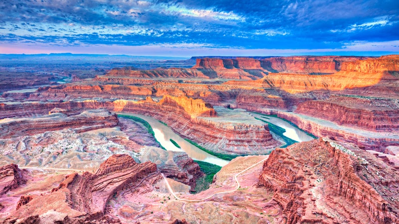
The most obvious side trip is one to neighboring Canyonlands National Park, about a half-hour southwest from Arches’��visitor center (although long lines might strand you on the entrance road for much longer). This section of the park rises like a wedge above the snaking Colorado and Green Rivers, whose tight bends carve striking canyons over 2,000 feet below. Cruise to to take in the stunning scenery. For a more��illuminating perspective on the local landscape, set out at dawn for the short hike to cliffside , which absolutely glows at sunrise; just know that you won’t be the only person jockeying for the perfect photo.
The same road that leads to Canyonlands, State Route 313, will also steer you toward , whose namesake overlook is worth the price of admission (from $20). But you’d be remiss to simply gawk and go; instead, leash up Fido to enjoy the roughly seven miles of trail that trace the rim, or saddle up to pedal the park’s network of beginner-to-intermediate-level mountain-bike trails. More experienced riders should head farther north on State Route��313 to the , a slickrock paradise best known for its namesake loop, a 17.5-mile, view-soaked roller coaster.
Although it’s incredible to scope the mighty Colorado River from high above its waters, make time to get down to��its level by driving all 44 eye-popping miles of State Route 128, most of which runs directly next to the iconic flow. Dip off the main drag for side trips to ogle—or even climb—the postcard spires of and ; a 4.5-mile trail weaves throughout the latter. If you want to get even closer to the river, consider launching your own craft or booking a guided rafting trip (the will steer you right).
If you’re short on time and can’t fit any of these lengthier options into your schedule, make tracks for , where a three-mile round-trip hike will deposit you on a slickrock slope beneath this gawk-worthy natural wonder.
How to Be a Conscious Visitor
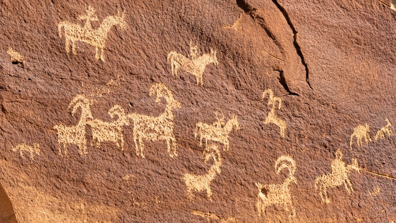
No matter what you choose to do during your visit to Arches, tread lightly. Stick to the park’s established trails and roads.��If you do go off-trail, travel only on rock and soft sand surfaces to avoid damaging the plentiful cryptobiotic soil, a living crust that helps tiny desert plants stay rooted and��retains moisture in the parched ground. Rock art is found throughout the park; if you are lucky enough to encounter some, appreciate it from afar. Finally, resist the urge to turn the park’s��actual arches into your own personal jungle gym. As you’ve no doubt learned, Mother Nature doesn’t need any assistance on the erosion front.